Showing 112998 items
matching tracks/roads
-
 Hawthorn Historical Society
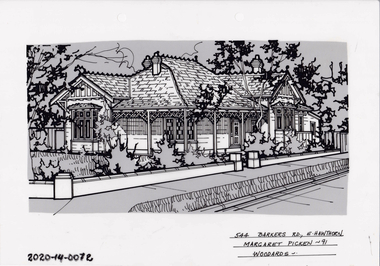
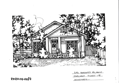
Drawing - Property Illustration, 544 Barkers Road, Hawthorn
'After training as a Cartographic Draftsman within the mining industry, I worked as a property illustrator for real estate firms in the eastern suburbs of Melbourne for 23 years from 1983. I initially photographed houses with a Polaroid camera and made a 'thumbnail' sketch while there. The photos were used to scale off a sketch in pencil and then that sketch was overlaid with drafting film and the 'pen and ink' completed. The pens I used were the Rotring ‘Rapidigraph’ drafting pens. The ink was also made by Rotring (German).The film was ‘Rapidraw’, polyester drafting film, double matte. It takes a very fine line and doesn’t bleed. As well as house sketches, there were often floor plans and site plans ordered. Aerial sketches were ordered when the property needed an overall view.' (Margaret Picken, 2020)This property illustration is one of a series created by Margaret Picken for a range of real estate agents in Melbourne between c. 1983 and c. 2006. Each work is signed and dated by the artist.Gift of Margaret Picken, 2020Pen and ink property illustration on drafting film of 544 Barkers Road, Hawthorn by Margaret Picken.544 Barkers Road, E Hawthorn, Margaret Picken '91. Woodards.artist - margaret picken 1950- -
 Hawthorn Historical Society
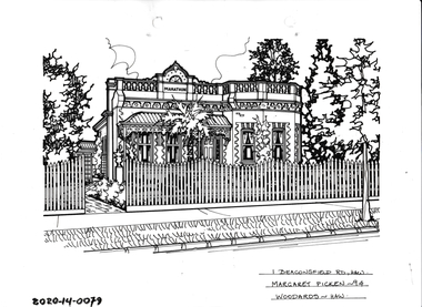
Drawing - Property Illustration, 1 Beaconsfield Road, Hawthorn
'After training as a Cartographic Draftsman within the mining industry, I worked as a property illustrator for real estate firms in the eastern suburbs of Melbourne for 23 years from 1983. I initially photographed houses with a Polaroid camera and made a 'thumbnail' sketch while there. The photos were used to scale off a sketch in pencil and then that sketch was overlaid with drafting film and the 'pen and ink' completed. The pens I used were the Rotring ‘Rapidigraph’ drafting pens. The ink was also made by Rotring (German).The film was ‘Rapidraw’, polyester drafting film, double matte. It takes a very fine line and doesn’t bleed. As well as house sketches, there were often floor plans and site plans ordered. Aerial sketches were ordered when the property needed an overall view.' (Margaret Picken, 2020)This property illustration is one of a series created by Margaret Picken for a range of real estate agents in Melbourne between c. 1983 and c. 2006. Each work is signed and dated by the artist.Gift of Margaret Picken, 2020Pen and ink property illustration on drafting film of 1 Beaconsfield Road, Hawthorn by Margaret Picken.1 Beaconsfield Road, Hawthorn, Margaret Picken '94. Woodards - Hawthorn.artist - margaret picken 1950- -
 Hawthorn Historical Society
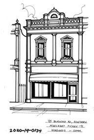
Drawing - Property Illustration, 93 Burwood Road, Hawthorn
'After training as a Cartographic Draftsman within the mining industry, I worked as a property illustrator for real estate firms in the eastern suburbs of Melbourne for 23 years from 1983. I initially photographed houses with a Polaroid camera and made a 'thumbnail' sketch while there. The photos were used to scale off a sketch in pencil and then that sketch was overlaid with drafting film and the 'pen and ink' completed. The pens I used were the Rotring ‘Rapidigraph’ drafting pens. The ink was also made by Rotring (German).The film was ‘Rapidraw’, polyester drafting film, double matte. It takes a very fine line and doesn’t bleed. As well as house sketches, there were often floor plans and site plans ordered. Aerial sketches were ordered when the property needed an overall view.' (Margaret Picken, 2020)This property illustration is one of a series created by Margaret Picken for a range of real estate agents in Melbourne between c. 1983 and c. 2006. Each work is signed and dated by the artist.Gift of Margaret Picken, 2020Pen and ink property illustration on drafting film of 93 Burwood Road, Hawthorn by Margaret Picken.93 Burwood Road, Hawthorn, Margaret Picken '91. Woodards - Comm.artist - margaret picken 1950- -
 Hawthorn Historical Society
Drawing - Property Illustration, 3 Fordholm Road, Hawthorn
'After training as a Cartographic Draftsman within the mining industry, I worked as a property illustrator for real estate firms in the eastern suburbs of Melbourne for 23 years from 1983. I initially photographed houses with a Polaroid camera and made a 'thumbnail' sketch while there. The photos were used to scale off a sketch in pencil and then that sketch was overlaid with drafting film and the 'pen and ink' completed. The pens I used were the Rotring ‘Rapidigraph’ drafting pens. The ink was also made by Rotring (German).The film was ‘Rapidraw’, polyester drafting film, double matte. It takes a very fine line and doesn’t bleed. As well as house sketches, there were often floor plans and site plans ordered. Aerial sketches were ordered when the property needed an overall view.' (Margaret Picken, 2020)This property illustration is one of a series created by Margaret Picken for a range of real estate agents in Melbourne between c. 1983 and c. 2006. Each work is signed and dated by the artist.Gift of Margaret Picken, 2020Pen and ink property illustration on drafting film of 3 Fordholm Road, Hawthorn by Margaret Picken.3 Fordholm Road, Haw, Margaret Picken '96. Woodards - Hawthorn. artist - margaret picken 1950- -
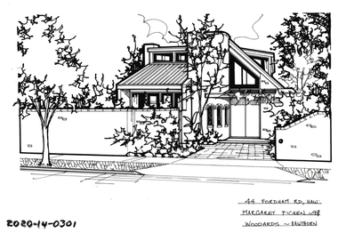 Hawthorn Historical Society
Drawing - Property Illustration, 44 Fordholm Road, Hawthorn
'After training as a Cartographic Draftsman within the mining industry, I worked as a property illustrator for real estate firms in the eastern suburbs of Melbourne for 23 years from 1983. I initially photographed houses with a Polaroid camera and made a 'thumbnail' sketch while there. The photos were used to scale off a sketch in pencil and then that sketch was overlaid with drafting film and the 'pen and ink' completed. The pens I used were the Rotring ‘Rapidigraph’ drafting pens. The ink was also made by Rotring (German).The film was ‘Rapidraw’, polyester drafting film, double matte. It takes a very fine line and doesn’t bleed. As well as house sketches, there were often floor plans and site plans ordered. Aerial sketches were ordered when the property needed an overall view.' (Margaret Picken, 2020)This property illustration is one of a series created by Margaret Picken for a range of real estate agents in Melbourne between c. 1983 and c. 2006. Each work is signed and dated by the artist.Gift of Margaret Picken, 2020Pen and ink property illustration on drafting film of 44 Fordholm Road, Hawthorn by Margaret Picken.44 Fordholm Road, Haw, Margaret Picken '99. Woodards - Hawthorn. artist - margaret picken 1950- -
 Hawthorn Historical Society
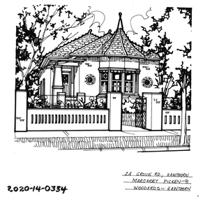
Drawing - Property Illustration, 2A Grove Road, Hawthorn
'After training as a Cartographic Draftsman within the mining industry, I worked as a property illustrator for real estate firms in the eastern suburbs of Melbourne for 23 years from 1983. I initially photographed houses with a Polaroid camera and made a 'thumbnail' sketch while there. The photos were used to scale off a sketch in pencil and then that sketch was overlaid with drafting film and the 'pen and ink' completed. The pens I used were the Rotring ‘Rapidigraph’ drafting pens. The ink was also made by Rotring (German).The film was ‘Rapidraw’, polyester drafting film, double matte. It takes a very fine line and doesn’t bleed. As well as house sketches, there were often floor plans and site plans ordered. Aerial sketches were ordered when the property needed an overall view.' (Margaret Picken, 2020)This property illustration is one of a series created by Margaret Picken for a range of real estate agents in Melbourne between c. 1983 and c. 2006. Each work is signed and dated by the artist.Gift of Margaret Picken, 2020Pen and ink property illustration on drafting film of 2A Grove Road, Hawthorn by Margaret Picken.2A Grove Road, Hawthorn, Margaret Picken '91. Woodards - Hawthorn. artist - margaret picken 1950- -
 Hawthorn Historical Society
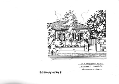
Drawing - Property Illustration, 21A Hambledon Road, Hawthorn
'After training as a Cartographic Draftsman within the mining industry, I worked as a property illustrator for real estate firms in the eastern suburbs of Melbourne for 23 years from 1983. I initially photographed houses with a Polaroid camera and made a 'thumbnail' sketch while there. The photos were used to scale off a sketch in pencil and then that sketch was overlaid with drafting film and the 'pen and ink' completed. The pens I used were the Rotring ‘Rapidigraph’ drafting pens. The ink was also made by Rotring (German).The film was ‘Rapidraw’, polyester drafting film, double matte. It takes a very fine line and doesn’t bleed. As well as house sketches, there were often floor plans and site plans ordered. Aerial sketches were ordered when the property needed an overall view.' (Margaret Picken, 2020)This property illustration is one of a series created by Margaret Picken for a range of real estate agents in Melbourne between c. 1983 and c. 2006. Each work is signed and dated by the artist.Gift of Margaret Picken, 2020Pen and ink property illustration on drafting film of 21A Hambledon Road, Hawthorn by Margaret Picken.21A HAMBLEDON ROAD, HAW Margaret Picken ~94 WOODARDS - HAWartist - margaret picken 1950- -
 Kiewa Valley Historical Society
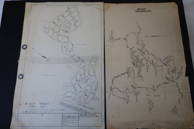
Maps - Bogong High Plains & Mt Beauty Township
The SECV continually updated their mapsDuring the development of the KHES the SECV had to continually update their mapsBoth Foolscap 1. Titled: High Plains Access Tracks & Roads 2. Mt Beauty Street Plan by SECV with Section Nos. and house numbersBoth have sticky tape marks on their back.khes maps -
 Glenelg Shire Council Cultural Collection
Photograph - Photograph - Main Breakwater construction, Portland, n.d
Port Of Portland AuthorityFront: 6-Blue biro Purple stamp- 'Portland Guardian' Back: 6- Blue biro Purple stamp- 'Portland Guardian'port of portland archives, main breakwater, harbour construction, development, euclid truck -
 Mt Dandenong & District Historical Society Inc.
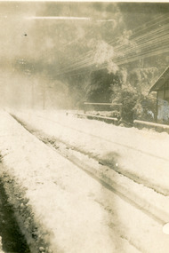
Photograph, Snow at Olinda 1921, 1921
Heavy snowfall on the road outside Quamby Café in Olinda in 1921. Car and bus tyre tracks are clearly visible. The photo appears to be taken through glass.Handwritten on back in blue pen: Snow 1921quamby, quamby, quamby cafe, olinda, snow -
 Hume City Civic Collection
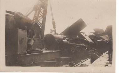
Photograph - Train smash, 17th April 1919
17th April 1919 a stock train travelling north crashed head-on with a goods train coming in the opposite direction. The driver thought he had been given the all-clear to proceed into Sunbury and it was only when the train was approaching the Macedon Street bridge that he saw the red light and it was too late. The accident caused damage to rolling stack and disruption on the Bendigo and Maryborough lines. The train coming from Bendigo smashed onto the platform at Sunbury. The driver of the stock train was thrown under the van and suffered a broken arm and facial injuries. The fireman was thrown clear of the tracks. A local Sunbury doctor treated them before they were taken by a casualty train to hospital. A crew from Melbourne came to Sunbury to repair the damage. The track was cleared by that afternoon. This photograph shows the crane lifting steam engine off the platform at Sunbury Station. This rail crash was one of many that has occurred in and near Sunbury and further on the tracks on the Bendigo Line over the years. A black and white photograph with a cream border of a steam train engine on its side with a crane lifting it back onto the rails. Two workmen are standing by the tracks.train crashes, sunbury station -
 Hawthorn Historical Society
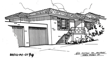
Drawing - Property Illustration, 2/ 23 Clifton Road, Hawthorn East
'After training as a Cartographic Draftsman within the mining industry, I worked as a property illustrator for real estate firms in the eastern suburbs of Melbourne for 23 years from 1983. I initially photographed houses with a Polaroid camera and made a 'thumbnail' sketch while there. The photos were used to scale off a sketch in pencil and then that sketch was overlaid with drafting film and the 'pen and ink' completed. The pens I used were the Rotring ‘Rapidigraph’ drafting pens. The ink was also made by Rotring (German).The film was ‘Rapidraw’, polyester drafting film, double matte. It takes a very fine line and doesn’t bleed. As well as house sketches, there were often floor plans and site plans ordered. Aerial sketches were ordered when the property needed an overall view.' (Margaret Picken, 2020)This property illustration is one of a series created by Margaret Picken for a range of real estate agents in Melbourne between c. 1983 and c. 2006. Each work is signed and dated by the artist.Gift of Margaret Picken, 2020Pen and ink property illustration on drafting film of 2/23 Clifton Road, Hawthorn East by Margaret Picken.2/23 Clifton Road, Hawthorn, Margaret Picken '87. artist - margaret picken 1950- -
 Melbourne Tram Museum
Photograph - Set of 15 Black & White Photograph/s, Melbourne & Metropolitan Tramways Board (MMTB), 1950's
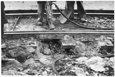
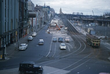
Series of 15 black and white photographs of the track works to reconstruct tram lines showing various methods and works during the 1960's. .1 - Jackhammers concrete out around wooden sleepers - the rails have been bolted to them. .2 - Excavated track or temporary track next to newly relaid track - Hawthorn Road by Caulfield Park? .3 - Partly completed work - nearest track relaid, second track still has wood blocks? and then a temporary track. .4 - Excavated previously concreted and bolted track. Appears to be new rail. .5 - Compacting a new track bed with work laying track in the background. .6 - Rail being craned into position onto small concrete blocks - Nicholson St North Fitzroy at Church St - the church is now Melbourne City Mission Palliative care centre. 1955/56 - construction of the replacement track. Note the Hail bus stop sign on the corner. .7 - Thermite welding being set up. .8 - after a Thermite welding joint completed. .9 - track reading for pouting concrete, with a rebuilt track alongside and temporary track on the other side. .10 - ditto .11 - Concrete being poured .12 - ditto - could be Maribyrnong Road bridge replacement. .13 - Screeding off the concrete - possibly Nicholson St North Fitzroy .14 - completed surface - location as above .15 - completed surface with cloth covers to assist the concrete being cured. Has a MMTB hut and two worker amenity buses alongside. - location as above.Some photos have pencil marks on rear.trams, tramways, trackwork, rails, track materials, track repairs, sleepers, equipment, concrete, welding, nicholson st, new tramway, buses -
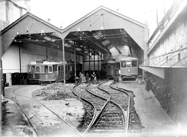 Ballarat Tramway Museum
Photograph - Geelong Tram Depot, Melbourne Electric Supply Co. (MESCo), c1924
Shows a near complete Birney car to the right, with cars 2,11, a trailer and car 12 in roads 1-4. The tracks to roads 3 and 4 are being realigned to accommodate a new track to road 5. 1924Yeilds information about the Geelong tramways buildings, cars and track realignment in 1924.Black and white print on paper.Plate 1-9 hand-written on back of photo.birney car, tram cars, track realignment geelong tram shed -
Whitehorse Historical Society Inc.
Letter - Correspondence, Yarran Dheran, 17/01/1979 12:00:00 AM
Letter from Yarran Dheran Committee of Management to Town Clerk, Nunawading 17/1/1979.Letter from Yarran Dheran Committee of Management to Town Clerk, Nunawading 17/1/1979 regarding walking and bicycle tracks between Schwerkolt Cottage and Yarran Dheran. With letter from Ann Creber to George Cox regarding meeting on the subject.Letter from Yarran Dheran Committee of Management to Town Clerk, Nunawading 17/1/1979.yarran dheran, parks and reserves, schwerkolt cottage, walking trails, bicycle paths -
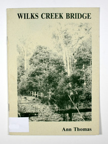 Marysville & District Historical Society
Book, Wilks Creek Bridge, 1993
A history of the Wilks Creek Bridge and its connection to the Yarra TrackPaperback. Front cover has an old photograph of the Wilks Creek Bridge.Dear Reader, The pen has only to select one of the many stages of building old Yarra Track,/ for a colorful story subject. The Track, first established in the early 1860's to/ serve goldseekers making their hazardous way to the rich Wood's Point goldfields,/ extended some 160km from Eltham - in Melbourne's northern region to Woods/ Point in the eastern ranges. I hope a glimmer of the excitement of those times comes through as I draw/ your attention to old Wilks Creek bridge and its picnic spot to be found 3.5km/ west of Marysville. Once part of Yarra Track and now superseded by a modern/ roadway alongside, the old bridge with its solid masonry walls either side of the/ cold, pure stream makes a pleasing scene for the visitor. With much pleasure/ I dedicate this narrative to Marysville and District Historical Society./ Ann Thomas Stamp of Marysville & District / Historical Society Inc / P.O. Box 22 / Marysville 3779wilks creek, marysville, yarra track, victoria, history, local history -
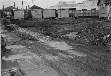 Melbourne Tram Museum
Photograph - Set of 4 Black & White Photograph/s, Melbourne & Metropolitan Tramways Board (MMTB), 1966
Series of 4 black and white photographs of the construction of three tracks or roads at East Preston Depot 7/1955. .1 - Mud mining - earthworks with the Stately Shoe and Wall Bros buildings in the view. .2 - showing one track complete with a second underway, .3 - two tracks complete with a third just in the view. .4 - pouring concrete at the depot - bicycle shed?trams, tramways, east preston, construction, trackwork, tram depot, track materials -
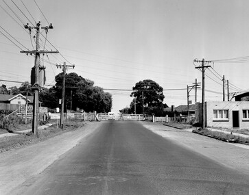 City of Kingston
Photograph - Black and white, Public Transport Corporation, c. 1960
Black and white photograph depicting closed crossing gates at the level crossing at Park Road, Cheltenham. This image is part of a larger collection of images from the Public Transport Corporation displaying train stations and streetscapes in what is now the City of Kingston.Black and white photograph of Cheltenham level crossing at Park Road, Cheltenham. The gates are closed. Stamped in blue ink on reverse: COPYRIGHT / Public Transport Corporation / For re-ordering photographs / Please quote negative No H3052 / Enquiries C/- PTC Photographic Unit / Telephone switchboard 619 111 White paper stuck to reverse of image, with black typed text: Cheltenham Park Road, Cheltenham / 1965 / $50 reproduction fee appliescheltenham, railway crossing, suburbs, public transport -
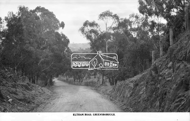 Eltham District Historical Society Inc
Photograph, The Rose Stereograph Company, Eltham Road. Greensborough, c.1936
Believed to be looking east along Eltham Road towards Eltham from around the top of the hill near the present day Andrew Yandell Habitat Reserve. Eltham Road, Greensborough followed what is now St Helena Road from Main Road Greensborough running into Karingal Drive and Sherbourne Road finishing at Bridge Street, Eltham. It was renamed sometime between 1968 and 1970. This glass plate negative was used to manufacture postcards (1:1 printing) for commercial sale by the Rose Sterograph Company and its subsidiaries. George Rose founded the Rose Stereograph Company in 1880 and was joined by Herbert (Bert) Cutts in the early 20th Century. The pair formed a lifetime working partnership and strong personal friendship. Assisted by George’s two sons, Herbert George and Walter, and later by Neil Cutts, the Rose Stereograph Company continued its operations for more than 140 years. The company was initially built on stereographs, but as cinema took over and stereographs fell out of fashion, the Rose Stereograph Company developed Australia’s first commercially viable photographic postcard business. Specialising in postcards of iconic historical moments and significant landmarks, The Rose Stereograph Company became a staple of the Australian travel industry.This remarkable collection of glass plate negatives, transparencies, and postcards – arguably Australia’s most significant photography collection outside of public hands – has been passed down through the generations, surviving war, relocation, and the harsh Victorian climate. The historic Rose Stereograph collection is the culmination of George Rose’s dream of capturing and preserving precious moments in time and remains the legacy of the Rose and Cutts families. It is with great sadness that the Cutts family says goodbye to a collection that spans five generations and 140 years. The Cutts family understands that for these historically important pieces to rest with one family is to deny others the pleasure of their custodianship.Glass Plate Negative Size: 9 x 13.9 cmEltham Road, Greensboroughpostcard, travel, rose stereograph company, glass plate negative, greensborough, cutting, eltham road, karingal drive, st helena road, peter and elizabeth pidgeon collection -
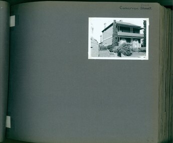 Glen Eira Historical Society
Album - Album page, Carnarvon Road, Circa 1972
This photograph is part of the Caulfield Historical Album 1972. This album was created in approximately 1972 as part of a project by the Caulfield Historical Society to assist in identifying buildings worthy of preservation. The album is related to a Survey the Caulfield Historical Society developed in collaboration with the National Trust of Australia (Victoria) and Caulfield City Council to identify historic buildings within the City of Caulfield that warranted the protection of a National Trust Classification. Principal photographer thought to be Trevor Hart, member of Caulfield Historical Society. Most photographs were taken between 1966-1972 with a small number of photographs being older and from unknown sources. All photographs are black and white except where stated, with 386 photographs over 198 pages. This house is part of HO14 Caulfield North and Environs - Heritage Overlay as a contributing property.Page 42 of Photograph Album with one photograph of a double-storey house on Carnarvon Road.Handwritten: Carnarvon Road [top right hand corner] / 42 [bottom right]trevor hart, caulfield north, carnarvon road, houses, verandahs, balconies, gardens -
Glenelg Shire Council Cultural Collection
Photograph - Photograph - Quay Road, Portland, 1980
Port of Portland Authority ArchievesBack: June 1980 No 2 Quay Road - top left corner in pencilport of portland archives, quay road, portland, grain, grain store, portland harbour, cargo -
Whitehorse Historical Society Inc.
Article, New tram link proves popular, 1979
Photocopy of article quoting Keith McCance, state member for Bennetswood commenting on the increase in patronage of the Burwood Road tram extension from Warrigal Road to Middleborough Road.Photocopy of article quoting Keith McCance, state member for Bennetswood commenting on the increase in patronage of the Burwood Road tram extension from Warrigal Road to Middleborough Road. Pressure is being applied to extend to Springvale Road.Photocopy of article quoting Keith McCance, state member for Bennetswood commenting on the increase in patronage of the Burwood Road tram extension from Warrigal Road to Middleborough Road. tram services, burwood road, burwood, mccance, keith -
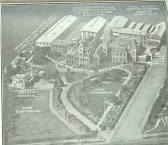 Vision Australia
Photograph - Image, Aerial view of the Royal Victorian Institute for the Blind grounds in St Kilda Road, 1927
Aerial photo of the RVIB St Kilda Road buildings and grounds, scanned from an unknown printed source. On the image are written descriptions of buildings, including the width and length of those erected in 1920's, the isolation hospital and the segregation of boys and girls playing areas. 1 scanned image of RVIB St Kilda Road from airGirls playground School & residential buildings Boys playground Isolation hospital This building, erected in 1926 - is 200 ft long & 40 ft wide Each floor of this new two storied building erected in 1926 is 100 ft long & 40 ft wide These recently erected factories measure 20,000 sq ft Ormond Hall for socials, etc. St Kilda Road frontageroyal victorian institute for the blind, buildings -
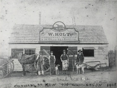 Kew Historical Society Inc
Photograph, Sandhill Forge, Cotham Road, c.1900
While a later inscription suggests that the photo dates from 1908, by that stage, according to the Sands & McDougall Directories, the forge on the corner of Cotham and Mont Victor Roads had been taken over by H. Wright. F.G.A. Barnard in his Jubilee History of Kew (1910) records that the well known Sandhill Nursery, had been established by William Holt early in the 1850s. Presumably this was an earlier business as by 1888 it is recorded that the business had become a forge. The forge stood on what is now part of the grounds of Genazzano Convent. A rare photograph of a pioneering industrial business in Kew on the site now occupied by Genazzano Convent.The photo shows W. Holt, Wheelwright, Veterinary and General - Blacksmith, Cotham Road, Kew. Inscription front: "Uncle Will Holt, Cotham Road, Kew, opp Normanby Av [sic] 1908 [sic]"; Reverse: "KHS February 1990. Gift of Mr Panther - Manager Westpac Bank, Kew. Given to Kew Historical Soc."sandhill forge, genazzano convent (kew), cotham road (kew), william holt -
 City of Kingston
Pamphlet - Black and white, Robert McCamish & John Gilpin (Vendors), For Private Sale Station Entrance Estate, Highett, 1930s
Sales plan for land in the suburb of Highett, bounded by Wickham Road, Railway Parade, Highett Road and Point Nepean Street. The developing urban area of Highett within the City of Kingston. This land sale pamphlet illustrates the subdivision of land within the municipality and the changing demographic of the district as new houses are constructed. The extension of the railway line from the city to Mordialloc opened up the land for development.Black and white pamphlet advertising for private sale the Station Entrance Estate, Highett. Incorporates a map of the estate bordered by Wickham Road, Railway Parade, Highett Road and Point Nepean Road. Handwritten in black ink on reverse: Station Entrance / Estate / Late [indecipherable]highett, land sales, estate -
Glenelg Shire Council Cultural Collection
Photograph - Photograph - Blacknose Quarry, 29/08/1952
Port of Portland Authority ArchivesFront: BLACKNOSE QUARRY ACCESS ROAD 29/8/52 - printed in bottom frame Back: Purple PHT stampport of portland archives, blacknose quarry -
 Melbourne Tram Museum
Slide - Set of 2, John Webster, 21/07/1959 12:00:00 AM
Set of two Colour slides, Kodak, white cardboard of trams of the construction of the Flinders St overpass over King St from the railway viaduct over Spencer St, looking east. Shows the temporary track on the south side of the bridge and the large car park under construction from the former cool stores on this site. Also shows the former track into Spencer St. Note the cross over at the base of the bridge. .1 - possibly 357 running a route 27 to Spencer St. Has the Great Southern Hotel on the left side. .2 - similar photo taken from the viaduct, further along - has the Bushels and Penfolds Wines signs in the background.Hand writing on rear in ink; .1 and .2 - "2-4-60 - Tracks - Flinders St Melbourne" Both slides have the speed and the f reading on the left hand side.trams, tramways, trackwork, flinders st, king st, track construction, bridges, w2 class, route 27, tram 357? -
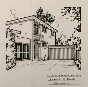 Kew Historical Society Inc
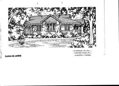
Drawing - Property Illustration, Margaret Picken, 130A Parkhill Road, Kew, 2002
After training as a Cartographic Draftsman within the mining industry, I worked as a property illustrator for real estate firms in the eastern suburbs of Melbourne for 22 years from 1983. I initially photographed houses with a Polaroid camera and made a 'thumbnail' sketch while there. The photos were used to scale off a sketch in pencil and then that sketch was overlaid with drafting film and the 'pen and ink' completed. The pens I used were the Rotring ‘Rapidigraph’ drafting pens. The ink was also made by Rotring (German).The film was ‘Rapidraw’, polyester drafting film, double matte. It takes a very fine line and doesn’t bleed. As well as house sketches, there were often floor plans and site plans ordered. Aerial sketches were ordered when the property needed an overall view. (Margaret Picken, 2020)This drawing is one of a series created by Margaret Picken for a number of real estate agents in Melbourne between 1983 and 2005. Each work is signed and dated by the artist.Gift of Margaret Picken, 2020Pen and ink architectural drawing on drafting film of 130A Park Hill Road, Kew by Margaret Picken.130A PARK HILL ROAD., KEW / PICKEN ©2002 / WOODARDSartist -- margaret picken 1950-, architectural drawings -- houses -- kew (vic.), 130a parkhill road -- kew (vic.) -
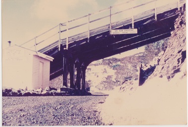 Falls Creek Historical Society
Photograph - Road Under Ski Run at Falls Creek, 1960
This ski run was built for the 1960 Australian Downhill Championships conducted at Falls Creek. It may have been built in conjunction with the SEC. This crossing was just below the Falls Creek Resort entrance. It had a vertical elevation of approximately 1,500 feet. The building pictured is a former SEC building which became the "Galleon" Ski Club and was later know as Cooroona. To the right is the Bowna Ski Club.This image is significant because it captures a structure created for the 1960 Australian Downhill Championships held at Falls Creek.Image of a road passing under a downhill ski run at Falls Creek. A building is visible on the left of the photo.On sign above road: SKI RUN CROSSING / DOWNHILL RACING COURSE1960 australian downhill championships, downhill ski run falls creek -
 Hawthorn Historical Society
Drawing - Property Illustration, 546 Barkers Road, Hawthorn East
'After training as a Cartographic Draftsman within the mining industry, I worked as a property illustrator for real estate firms in the eastern suburbs of Melbourne for 23 years from 1983. I initially photographed houses with a Polaroid camera and made a 'thumbnail' sketch while there. The photos were used to scale off a sketch in pencil and then that sketch was overlaid with drafting film and the 'pen and ink' completed. The pens I used were the Rotring ‘Rapidigraph’ drafting pens. The ink was also made by Rotring (German).The film was ‘Rapidraw’, polyester drafting film, double matte. It takes a very fine line and doesn’t bleed. As well as house sketches, there were often floor plans and site plans ordered. Aerial sketches were ordered when the property needed an overall view.' (Margaret Picken, 2020)This property illustration is one of a series created by Margaret Picken for a range of real estate agents in Melbourne between c. 1983 and c. 2006. Each work is signed and dated by the artist.Gift of Margaret Picken, 2020Pen and ink property illustration on drafting film of 546 Barkers Road, Hawthorn East by Margaret Picken.546 Barkers Road, Haw E, Margaret Picken '98. Woodards.artist - margaret picken 1950-