Showing 9343 items matching "warrandyte"
-
 Ringwood and District Historical Society
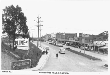
Photograph, Maroondah Highway Central, Ringwood. Whitehorse Road looking west from Warrandyte Road. c1930's
Black and white photograph (2 copies)Inscribed on photograph: "Series No 4. Whitehorse Road, Ringwood. Image shows shops on north side of road from Warrandyte Road railway bridge to Ringwood Street. -
 Ringwood and District Historical Society
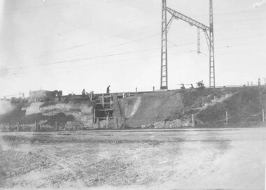
Photograph, Maroondah Highway East, Ringwood- 1923. Start of Warrandyte Road railway bridge construction
Black and white photograph (3 copies- 2 large, 1 small sepia)Typed below large photograph: "Building Warrandyte Rd. subway 1923. Taken from Maroondah Highway." Written on rear of backing sheet: "Start of Pitt St. viaduct." -
 Ringwood and District Historical Society
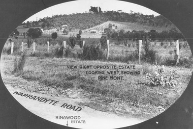
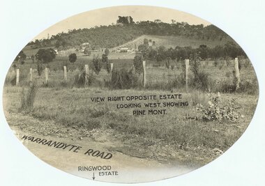
Photograph, View from Warrandyte Road opposite Ringwood Estate looking west, showing Pine Mont. (no date)
Printed onto photograph, "View right opposite estate looking west, showing Pine Mont". Roadway identified as "Warrandyte Road" and "Ringwood Estate" printed at bottom of picture. -
 Ringwood and District Historical Society
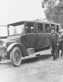
Photograph, William Hussey and William John Hussey with the first bus on the Ringwood - Warrandyte run.1926, incl Timetable
Black and white photograph (2 images- P0129a and P0129b)Photo P0129a: "Hussey 1926", shows William Hussey standing next to motorised coach with passengers on board. Photo P0129b: "Ringwood-Warrandyte Coach Service, Time Table". -
 Ringwood and District Historical Society
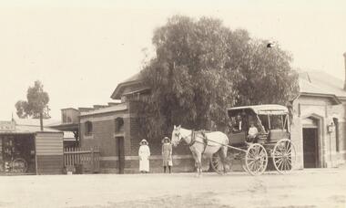
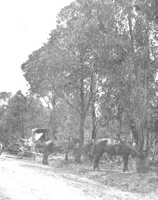
Photograph, Ringwood Station entrance - Ringwood to Warrandyte coach 1920
Black and white photographs {2copies - 1 large, 1 small postcard}Typed below photograph, "Ringwood to Warrandyte coach outside Ringwood Station entrance - 1920". Horse and cart standing in front of building with two women standing beside horse. -
 Ringwood and District Historical Society
Photograph, Continuation of Warrandyte Rd. to Bedford Road, Ringwood. Tibbs Licenced Grocers Store, 1967
Written on back of photograph, "Continuation of Warrandyte Rd. to Bedford Road, 1967. Tibbs Licenced Grocers". "New parking area - Pitt St. Ringwood". "Bryan Dales, photographer, Bayswater.." -
 Ringwood and District Historical Society
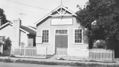
Photograph, Salvation Army Hall, Warrandyte Road, Ringwood - circa 1960s
Black and white photograph of wooden building with picket fence.Typed below photograph, "Salvation Army Hall, Warrandyte Road, Built 1920." Written on backing sheet, "Sal. Army Hall, 1/1964. Built 1920, W'dyte Rd." -
 Ringwood and District Historical Society
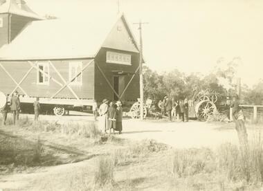
Photograph, Church of England relocation: About to cross bridge over Mullum Creek, Warrandyte Rd (undated)
Smaller photograph that appears to be the original from which this photograph was taken reads, "About to cross bridge over Mullum Creek, Warrandyte Rd. English Church" Appears to be Church of England. -
 Ringwood and District Historical Society
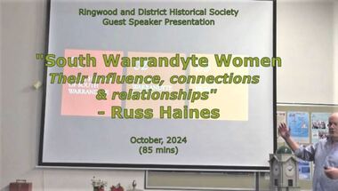
Mixed media - Video, RDHS Meeting Presentation - "South Warrandyte Women - their influence connections & relationships" - Russ Haines
Digitised video (4.64GB). Duration: 85 minutes. Recorded October, 2024 (Video is available for viewing at Ringwood & District Historical Society Archives by appointment)In this presentation, Ringwood and District Historical Society President Russ Haines introduces a brief history of the South Warrandyte area and focuses on the community spirit and collective support amongst women of the district. -
 Ringwood and District Historical Society
Photograph, Maroondah Highway East, Ringwood- 1914. Mr. O.J. Pratt's butcher shop under construction, cnr Main Street and Warrandyte Road
Black and white photograph (2 copies)Typed below photograph: "Mr. O.J. Pratt's butcher shop being constructed corner Warrandyte Rd. and Main St. (Demolished for road widening) 1914. Site became C.B.C. Bank. -
 Ringwood and District Historical Society
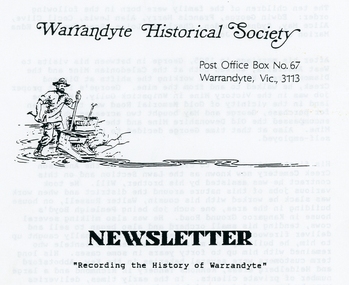
Photograph, Warrandyte Historical Society Newsletters nos. 85-91
Digitised WHS newsletters from June 1992 (no. 85) to June 1993 (no. 91). Sent to Secretary of the Ringwood Historical Research Group, Jack Lindsay.Noteable articles:- Fitzsimons Lane Johansen, Johansons Road Belzer family Sir George Oswald Reid QC Growler's Hill tank Ruby Arnaud North Warrandyte Fire Brigade -
 Ringwood and District Historical Society
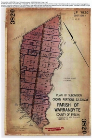
Document, Titles of land subdivision, Crown Portions 32, 33 & 34, Parish of Warrandyte, 1884 and 1907, Ringwood, Victoria
Evolution of the subdivision and the use of landBlack plastic bound pockets containing copies of 18 LANDATA subdivision maps and mortgage transfer pages dating from 1884 for 303 acres 2 roods and 1 perch bounded by Warrandyte Road, Wonga Road, Oban Road and Mullum Mullum Creek in Ringwood, Victoria. Certificates of Title include Vol 1606 Fol 045 Frederick Walter Purches 1884 and subsequent transfers to 1902, and Vol 3232 Fol 646357 Ann Jane Kennedy 1907 and transfers to 1921. -
 Ringwood and District Historical Society
Photograph, Warrandyte Historical Society Newsletters nos. 76-84
Digitised WHS newsletters from December 1990 (no. 76) to October 1990 (no. 84). Sent to Secretary of the Ringwood Historical Research Group, Jack Lindsay.Noteable articles:- Earl Stewart bus service Brackenbury Street Yarra Yarra Mining Company Dr Owen's Puddling Machine 1927 bushfires Schult Steven Houghton Taffy Jones Great Southern Hill Caledonia Gold Mine Mary Hill - South Warrandyte Post Office Artists - Nutter Buzacott, Frank Crozier, Penleigh Boyd, William Frater, Christine Gray-Aldor Warrandyte Primary School Potter's Cottage -
 Ringwood and District Historical Society
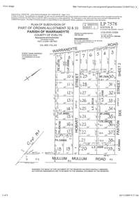
Document - Subdivision Plan, Part of Crown Allotment 32 & 33 Parish of Warrandyte, County of Evelyn Vol 3922 Fol 242
LANDATA Land Victoria 2-sheet plan printout dated 16/6/1919.Sheet 1 includes Warrandyte Road, Hobart Street, Paxton Street, and Mullum Mullum Road, Ringwood, Vic. Additional markings include PS327701, LP215189, RP7936, LP110103, LP36735, LP31149, SP24012, PS310739, PS326740, PS336885, LP41558. Sheet 2 includes Warrandyte Road, Paxton Street, Arnold Street, and Mullum Mullum Road, Ringwood, Vic. Additional markings include RO270, SP26622, LP50242, RP19467, SP27005, SP31440, PS312181. -
 Ringwood and District Historical Society
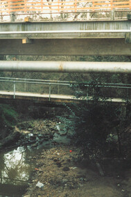
Photograph, Ringwood, Mullum Mullum Creek, east side. Warrandyte Road Bridge. 1986
Written on backing sheet, "Bridge, Mullum Rd. Completed May 1987." Writing on back of photograph reads, "Aug., 1986. Ringwood, Mullum Mullum Creek, east side. Warrandyte Road Bridge". -
 Ringwood and District Historical Society
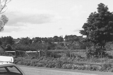
Photograph, Looking N.E. across Warrandyte Road 150 yards north of Oban Rd. at the houses around and SE of Parkwood High School 1981
Written on back of photograph, E607, N10, 19/6/1981. Looking N.E. across Warrandyte Road 150 yards north of Oban Rd. at the houses around and SE of Parkwood High School". -
 Ringwood and District Historical Society
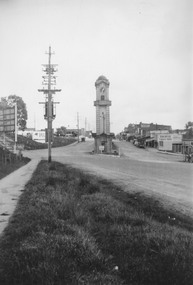
Photograph, Maroondah Highway Central, Ringwood. Clocktower at intersection of Warrandyte Road and Main Street, 1950
Black and white photograph (2 copies- 1 large, 1 small)Typed under large copy: "Maroondah Highway showing cnr Warrandyte Rd, clocktower at old position. Old Station Masters residence, and shops on right which are now demolished for Safeway store." -
 Ringwood and District Historical Society
Photograph, Maroondah Highway Central, Ringwood. Clocktower and Main Street, c1930.Postcard view of the clocktower and main street from the railway bridge above Warrandyte Road and Maroondah Highway, Ringwood - c.1930
Black and white photograph (2 copies)Typed below photograph: "Shops on right now Safeway site - c1930". Written on backing sheet of one photograph, "Original site of Ringwood Memorial Clocktower. Intersection Maroondah Highway and Warrandyte Rd." -
 Ringwood and District Historical Society
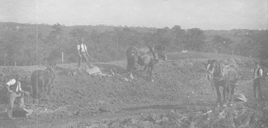
Photograph, Roadmaking by McGiverns. Warrandyte Rd. just north of Mullum Creek. 1920s
Typed below photograph, "Roadmaking in Ringwood in the 1920s". Catalogue card reads, "Roadmaking by McGiverns. Warrandyte Rd. just north of Mullum Creek". Written on backing sheet, "McGiverns of Croydon in Andersons Creek Road". -
 Ringwood and District Historical Society
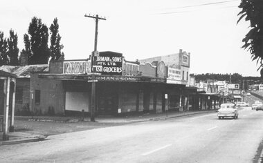
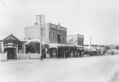
Photograph, Maroondah Highway Central, Ringwood. Corner Main Street & Adelaide St. looking east towards Warrandyte Road- 1966
History of the Norman Cash Grocery Stores. Normans started grocery store in Drummond Street Oakleigh in 1903 and expanded to 13 stores in adjacent suburbs, Ringwood being one of these. Photo is Norman & Sons P/L corner of Maroondah Highway and Adelaide Street.Black and white photograph (2 copies) Typed below one copy: "Corner Main Street & Adelaide St. looking east towards Warrandyte Road - 1966". Image shows Norman & Sons Grocer store on corner of Adelaide Street and Main Street. -
 Ringwood and District Historical Society
Photograph, Promotional photograph - View opposite Ringwood Estate, Warrandyte Road, looking west towards Pine Mont. (no date)
Printing on photograph reads, "View right opposite estate looking west, showing Pine Mont. Warrandyte Road". Catalogue card reads, "Pinemont Estate (Loughnan's Hill). Right opposite estate looking west." -
 Ringwood and District Historical Society
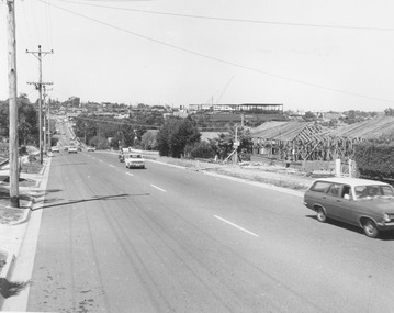
Photograph, Warrandyte Rd. looking south towards Maroondah Hwy. Eastland second storey being built - c.1974
Typed below photograph, "Warrandyte Rd. looking south towards Maroondah Hwy. Eastland second storey being built - 1974?" Catalogue card states, "Frames to right are on site of 'Woodside' - Miss Huttons house". -
 Ringwood and District Historical Society
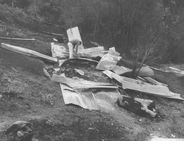
Photograph, Ringwood Rifle Range, Warrandyte after bushfire 1962
Written on back of one of the photographs, "Ringwood Rifle Range, Warrandyte after bushfire 1962. Remains of target shed near entrance to pit. R. Johnson, Peter Pullin (with stick), R. Pullin, J. Hinds". -
 Ringwood and District Historical Society
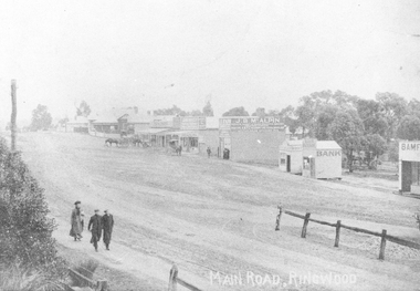
Photograph, Maroondah Highway Central, Ringwood. Looking west from Warrandyte Road, 1910
Black and white photograph (2 copies)Written on rear of backing sheet of one photograph: "Main Road, Ringwood, looking west, Warrandyte Road coming in from right.". Image of central Ringwood including the E.S.& A. bank, Ringwood's first bank, 1910. -
 Ringwood and District Historical Society
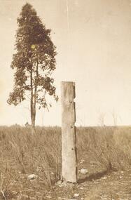
Photograph, Last post of stockyard, Blood's paddock, corner Wonga and Warrandyte Roads, Ringwood 1910 (4 views)
4 small sepia photographs Written on reverse 2434-1 & -2: "Part of old stockyard, Blood's Paddock, Wonga Road. Arnott's, 1910." 2334-4: "Last post of stockyard in Blood's Paddock, corner Wonga Road and Warrandyte Roads" -
 Eltham District Historical Society Inc
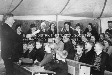
Photograph, The Age, Mr. William H. Everard, M.L.A. addressing children at South Warrandyte Primary School, 30 Jun 1939
South Warrandyte State School was destroyed in the Black Friday bushfire of 13 Jan. 1939. Whilst a new school building was being constructed, classes were conducted in a tent as seen in this image from 'The Age" of Mr William Everard, M.L.A.delivering his 22nd annual Arbor Day address to children of the school on 30 June 1939. Mr Everard returned on October 7 to officially open the new school.south warrandyte state school, william h. everard, arbor day, black friday -
 Nillumbik Shire Council
Painting: Guy STUART (b.1942 ACT), Guy Stuart, Tunnel by the Yarra, 2004
An abstract painting of the Yarra River from Pound Bend in Warrandyte. The painting is quite expressive, linear and gestural in style. Muted, neutral tones of greens, browns and reds. -
 Ringwood and District Historical Society
Photograph, Roadmaking by McGivens, Warrandyte Rd. just north of Mullum Creek. Easier to camp on job rather than take horses and machinery to and from Croydon. 1920s
Typed below photograph, "Roadmaking in Ringwood in the 1920s." Catalogue card reads, "Roadmaking by McGivens, Warrandyte Rd. just north of Mullum Creek. Easier to camp on job rather than take horses and machinery to and from Croydon." -
 Ringwood and District Historical Society
Photograph, Maroondah Highway Central, Ringwood. Looking east towards Adelaide Street and Warrandyte Road, 1918
Black and white photograph (3 copies- 2 large, 1 small).Typed below one large photograph: "Maroondah Hwy. 1918. Taken from outside railway station looking towards Warrandyte Rd." Image shows Coffee Palace and general store in middle, and Ringwood Post Office to the left. -
 Ringwood and District Historical Society
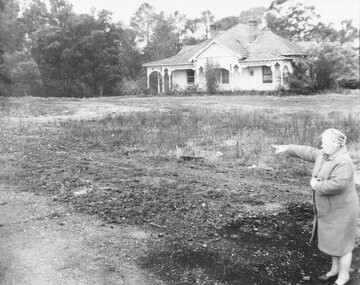
Photograph, Mrs. E.V. Pullin, Chairman Library Promotion Committee pointing to new library site - 1967 - opposite Eastland and the bowling green, Warrandyte Road. Five photographs
Mrs. E.V. Pullin, Chairman Library Promotion Committee pointing to library site - 1967 - opposite Eastland and the bowling green, Warrandyte Road. House on the library site was demolished at the end of 1968 and the library opened on 2nd May 1970.