Showing 1137 items
matching waterways
-
 Lakes Entrance Regional Historical Society (operating as Lakes Entrance History Centre & Museum)
Postcard - Gippsland Lakes, Bulmer and Segerberg, 1915c
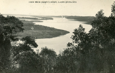
... Waterways ...Black and white postcard of the Gippsland lakes, taken from Jemmys Point. It shows Rigby Island, Fraser Island and Flannagan Island, Reeves Channel. Natural vegetation in foreground. Lakes Entrance VictoriaView from Jimmy's Point Lakes Entranceislands, waterways, topography -
 Lakes Entrance Regional Historical Society (operating as Lakes Entrance History Centre & Museum)
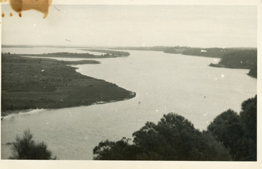
Photograph - Reeves River, 1910c
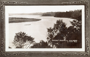
... Waterways ...Also another copy print 8 x 13, both printed as though framedBlack and white photograph of Reeves Channel, Gippsland Lakes. It shows Rigby Island opposite the steep cliffs of mainland shore. Small island off Rigby was known as the Doughboy. Taken from Jemmys Point, natural vegetation in foreground. Lakes Entrance VictoriaReeves River from Kalimnaislands, waterways, topography -
 Lakes Entrance Regional Historical Society (operating as Lakes Entrance History Centre & Museum)
Photograph - Fraser Island, Holding M, 2000c
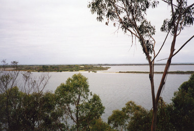
... Waterways ...Colour photograph of Fraser Island, Gippsland Lakes, taken from Nyerimilang. It shows Flannagan Island mid centre, residence on Fraser Island, scrub covered dunes of southern shore of lake system. Lakes Entrance Victoria waterways, topography, islands -
 Lakes Entrance Regional Historical Society (operating as Lakes Entrance History Centre & Museum)
Photograph - Maringa Creek, 1997c
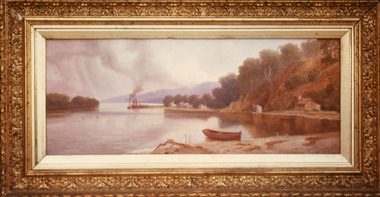
... Waterways ...Walter Seehusan, first art teacher at Bairnsdale School of Mines. Painting in possession of St Nicholas Anglican Church, Lakes Entrance, Victoria, bequeathed by Miss E L Phillips. Original painting 1890c.Colour photograph of a painting by W Seehusan of view from site of Kalimna Jetty towards Nungurner, showing mill workers cottages, jetty and steamers at Maringa Creek sawmill. Fisherman's cottage in right foreground, settlement at Maringa Creek, Gippsland Lakes, by mill workers and fishermen. Painting shows denuded cliffs and timber slide. Lakes Entrance Victoriawaterways, boats and boating, settlement -
 Lakes Entrance Regional Historical Society (operating as Lakes Entrance History Centre & Museum)
Photograph - S.S. Gippsland, 1930c
... Waterways ...Black and white photograph of the steamer Gippsland at Nyerimilang Jetty, Gippsland Lakes. Jetty has navigation light but no storage shed at this time. Three smaller boats moored at jetty. Lakes Entrance Victoria waterways, ships and shipping, jetties -
 Lakes Entrance Regional Historical Society (operating as Lakes Entrance History Centre & Museum)
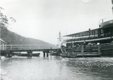
Photograph - Kalimna Jetty, 1930c
... Waterways ...Black and white photograph of Kalimna Jetty. It shows a substantial jetty and landing, storage shed and boat shed, navigation light on end of jetty, many people on jetty, perhaps waiting for arrival of passenger steamer, in background steep cliffs bordering shoreline. Lakes Entrance Victoriawaterways, topography, jetties -
 Lakes Entrance Regional Historical Society (operating as Lakes Entrance History Centre & Museum)
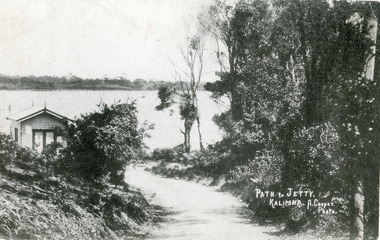
Postcard - Kalimna Jetty, Cooper Alexander, 1915c
... Waterways ...Second copy 8 x 14Black and white postcard of the track to Kalimna Jetty Gippsland Lakes Victoria showing shed at approach to jetty, lake and Rigby Island in background. Lakes Entrance VictoriaPath and Jetty Kalimnajetties, waterways, roads and streets -
 Lakes Entrance Regional Historical Society (operating as Lakes Entrance History Centre & Museum)
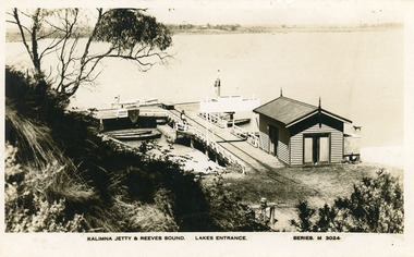
Postcard - Kalimna Jetty, Valentine Series, 1930c
... Waterways ...Also Black and white copy print 15 x 25Black and white postcard of Kalimna Jetty. It shows a substantial timber jetty with rail line and goods trolley, storage shed with square water tank. Passenger launch and four rowing boats moored at jetty. Navigation light towards end of jetty. Lakes Entrance VictoriaKalimna Jetty and Reeves Sound Lakes Entrance Series M 3024 jetties, waterways, boats and boating -
 Lakes Entrance Regional Historical Society (operating as Lakes Entrance History Centre & Museum)
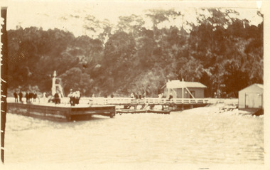
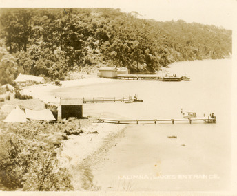
Postcard - Kalimna Jetty, 1920c
... Waterways ...also identical print, poor quality 7 x 8.5|also black and white 10 x 12.5|also copy sepia tone 10 x 15|also poor quality black and white 12.5 x 17.5Black and white small format postcard of three jetties at Kalimna Gippsland Lakes Victoria. It shows tents of campers on lake edge, steep cliffs in background, small boats at jetties, person fishing from jetty. Lakes Entrance VictoriaKalimna Lakes Entrance jetties, waterways, boats and boating -
 Lakes Entrance Regional Historical Society (operating as Lakes Entrance History Centre & Museum)
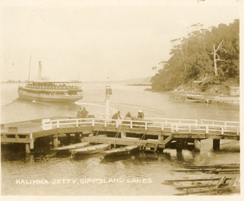
Postcard - Kalimna Jetty, 1920c
... Waterways ...also Black and white copy 10 x 12|also Sepia toned copy 10 x 15Sepia toned small format postcard of the steamer Gippsland leaving Kalimna Jetty, Gippsland Lakes Victoria, also showing boat ramps beside jetty, three rowing boats moored at lower landing, persons pushing trolly along jetty, Navigation light on jetty, rustic jetty and small boat in background. Lakes Entrance VictoriaKalimna Jetty Gippsland Lakesjetties, waterways, ships and shipping -
 Lakes Entrance Regional Historical Society (operating as Lakes Entrance History Centre & Museum)
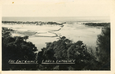
Postcard - The Entrance, 1940c
... Waterways ...Also one similar images, 7 x 12.5, donated by Pam Cole, Lara VicBlack and white postcard of Bullock Island, and rock groynes, Reeves and Entrance Channels and Carpenter Town at the New Works, taken from Jemmys Point, dense vegetation in foreground. Lakes Entrance VictoriaThe Entrance Lakes Entrance waterways, topography, township -
 Lakes Entrance Regional Historical Society (operating as Lakes Entrance History Centre & Museum)
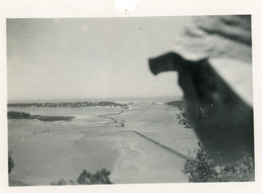
Photograph, 1950c
... Waterways ...Black and white photograph of Bullock Island and rock groynes, Carpenter Town settlement at New Works, and the Entrance at Lakes Entrance, Victoriawaterways, dredging, islands -
 Lakes Entrance Regional Historical Society (operating as Lakes Entrance History Centre & Museum)
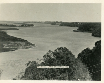
Postcard - Reeves Channel, Valentine Series, 1930c
... Waterways ...Other copy similar view with inscription 'The Lakes, Lakes Entrance Vic'Black and white postcard of Reeves Channel Gippsland Lakes, showing Rigby, Fraser and Flannagan Islands opposite the steep shoreline of the mainland. Natural vegetation of Jemmys Point in foreground from which photograph was taken. Lakes Entrance VictoriaKalimna from Jemmys Point Lakes Entranceislands, waterways, topography -
 Lakes Entrance Regional Historical Society (operating as Lakes Entrance History Centre & Museum)
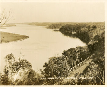
Postcard - Reeves Channel, Valentine Series, 1930c
... Waterways ...Black and white small format postcard of Reeves Channel Gippsland Lakes, taken from Jemmys Point. It shows a glimpse of the Princes Highway, the steep shoreline of the mainland opposite Rigby Island with Fraser Island and Flannagan Island in distance. Lakes Entrance VictoriaKalimna Cove Lakes Entranceislands, waterways, topography -
 Lakes Entrance Regional Historical Society (operating as Lakes Entrance History Centre & Museum)
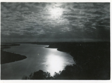
Postcard - Reeves Channel, 1930c
... Waterways ...3 identical 6 x 8.5|1 same size hand tinted 6 x 8.5Black and white small format postcard of a sunset scene on Reeves Channel, Gippsland Lakes. It shows sunlight reflected through clouds and on the lake between Rigby Island and the mainland. Lakes Entrance Victoriaislands, waterways, topography -
 Lakes Entrance Regional Historical Society (operating as Lakes Entrance History Centre & Museum)
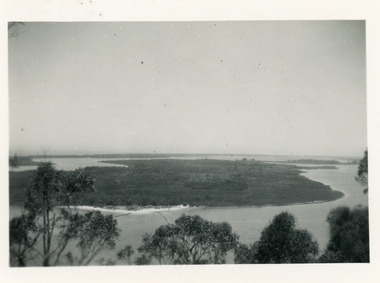
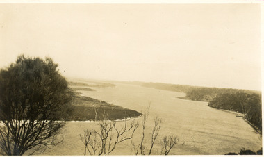
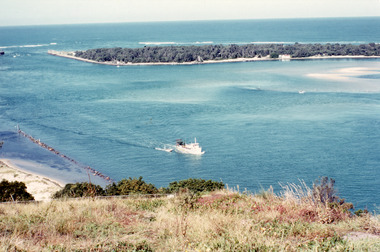
Photograph - Rigby Island, 1930c
... Waterways ...Second copy similar viewBlack and white photograph of Rigby Island, Gippsland Lakes Victoria. It shows Reeves Channel on right of photo, Hopetoun Channel on left, The Narrows below Jemmys Point from which photo was taken. Lakes Entrance Victoriaislands, waterways, topography -
 Lakes Entrance Regional Historical Society (operating as Lakes Entrance History Centre & Museum)
Postcard - The Narrows, 1930c
... Waterways ...Black and white small format postcard of a steamer in the Narrows, Rigby Island opposite the steep shoreline of the mainland, Reeve's Channel, Fraser Island and Flannagan Island in distance, Gippsland Lakes, Lakes Entrance Victoria.islands, waterways, topography -
 Lakes Entrance Regional Historical Society (operating as Lakes Entrance History Centre & Museum)
Photograph - Lake King, Tambo Shire, 1995c
... Waterways ...Also second copyColour photograph of portion of Rigby Island, Fraser Island, and Flannagan Island, and Reeves Channel of Lake King, Gippsland Lakes. Steep shore of mainland in distance. Lakes Entrance Victoriaislands, waterways, topography -
 Lakes Entrance Regional Historical Society (operating as Lakes Entrance History Centre & Museum)
Photograph - Lake King, 1950c
... Waterways ...Also copy of same view, stained, 9 x 14Black and white photograph of the Narrows and Reeves Channel of Lake King, Gippsland Lakes. It shows Rigby, Fraser, and Flannagan Islands opposite the steep shoreline of the mainland. Taken from Jemmy's Point, it shows a recently built groyne from Rigby Island into the Narrows. Lakes Entrance Victoriaislands, waterways, topography -
 Lakes Entrance Regional Historical Society (operating as Lakes Entrance History Centre & Museum)
Photograph - Reeves Channel, 1930c
... Waterways ...Black and white photograph of Reeves Channel on Lake King, Gippsland Lakes. It shows part of Rigby Island opposite the steep mainland shore of the lake. Lakes Entrance Victoriaislands, waterways, topography -
 Lakes Entrance Regional Historical Society (operating as Lakes Entrance History Centre & Museum)
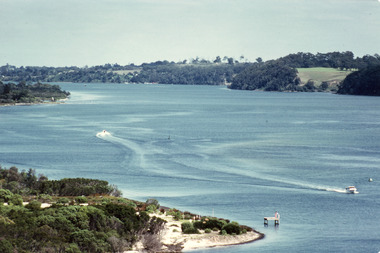
Photograph - Reeves Channel, Fraser, Ian, 1995c
... Waterways ...Colour photograph of Reeves Channel of Lake King, Gippsland Lakes. It shows part of both Rigby Island and Fraser Island opposite the steep shoreline of the mainland. Two motor boats on lake. Lakes Entrance Victoriaislands, waterways, topography -
 Lakes Entrance Regional Historical Society (operating as Lakes Entrance History Centre & Museum)
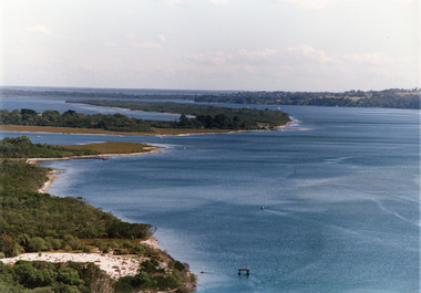
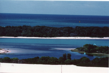
Photograph - The Entrance, Fraser, Ian, 1990c
... Waterways ...Colour photograph of the lake. It shows a fishing boat with scallop dredge moving up the lake opposite the artificial entrance, grassy edge of Jemmy's Point in foreground above highway guard fence, rock groyne at entry to North Arm, sandy shallows at entry to Hopetoun Channel, scrub covered hummocks of south shore and Bass Strait in distance. Lakes Entrance Victoriaislands, waterways, topography -
 Lakes Entrance Regional Historical Society (operating as Lakes Entrance History Centre & Museum)
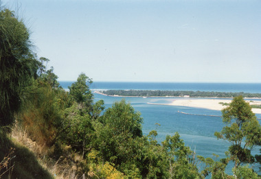
Photograph - Hopetoun Channel, Fraser, Ian, 1996c
... Waterways ...Colour photograph of Bass Strait, scrub covered coastal dunes, Hopetoun Channel, and southern portion of Rigby Island. Photo taken from sand dunes on Flannagan Island, near Lakes Entrance, Victoria.islands, waterways, topography -
 Lakes Entrance Regional Historical Society (operating as Lakes Entrance History Centre & Museum)
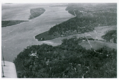
Photograph - Kalimna, Bulmer H D, 1940c
... Waterways ...Black and white photograph of view over Kalimna, Maringa Creek, Saw Mill Flat, Fraser Island, Flannagan Island, aireal view. Lakes Entrance, Victoria.waterways, topography, townships -
 Lakes Entrance Regional Historical Society (operating as Lakes Entrance History Centre & Museum)
Photograph - The Entrance, 1992c
... Waterways ...Colour photograph of the western side of the Entrance. It shows scrub covered hummocks, dredged sand dumped at Snake Island, rock groynes from island to lake, taken from lower side of highway at Jemmys Point. Lakes Entrance Victoriaislands, topography, waterways -
 Lakes Entrance Regional Historical Society (operating as Lakes Entrance History Centre & Museum)
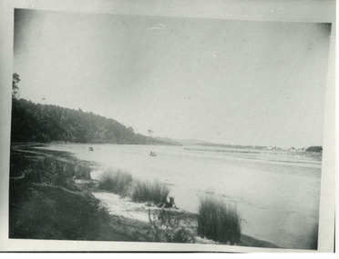
Photograph - North Arm, Phillips, Miss L, 1910c
... Waterways ...Black and white photograph of North Arm. It shows the reedy shoreline in foreground, jetty to island in lake, two small boats on water, distant view of township. Lakes Entrance Victoriawaterways, topography, vegetation -
 Lakes Entrance Regional Historical Society (operating as Lakes Entrance History Centre & Museum)
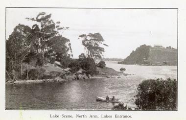
Photograph - North Arm, 1920c
... Waterways ...Copy same view but titled 'North Arm - Lakes Entrance' 11.5 x 18Black and white photograph of the North Arm. It shows the calm waters of the arm which twist and turn between high scrub covered banks. Distant view of township, two people in small boat in foreground. Lakes Entrance VictoriaLakes Scene North Arm Lakes Entrancevegetation, topography, waterways -
 Lakes Entrance Regional Historical Society (operating as Lakes Entrance History Centre & Museum)
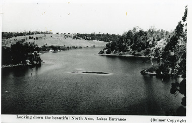
Photograph - North Arm, Bulmer H D, 1930c
... Waterways ...Black and white photograph of the North Arm, showing the calm waters between steep banks covered in natural vegetation, but for one hillside which has been almost completely cleared, a few ring barked trees still standing. Lakes Entrance VictoriaLooking down the beautiful North Arm Lakes Entrancevegetation, waterways, topography -
 Bendigo Historical Society Inc.
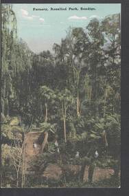
Postcard - FERNERY, ROSALIND PARK, BENDIGO
colour postcard: Fernery, Rosalind park, Bendigo. Image shows Fernery in Rosalind Park, Bendigo. Lush foliage, including tree ferns, taller eucalypt trees in background. 4 children in foreground, one standing on bridge over waterway. On rear written in black pen: ' this is a good one of the Park, don't you think - I suppose you remember when we went there - With love, May.' Addressed to Miss E M Dahlsen, Nicholson Street, Bairnsdale. Stamp has Victoria, One penny, printed.bendigo, parks and gardens, fernery, rosalind park, bendigo, fernery, rosalind park -
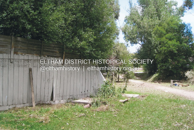 Eltham District Historical Society Inc
Photograph, Fay Bridge, Flood damage at Nillumbik Medical Centre, 1078 Main Road, Eltham, 26 December 2011
Flood damage resulting from a late afternoon storm on Christmas Day 2011. A flash flood occurred from significant rain fall and hail, which accumulated along an old waterway with floodwater submerging cars along Valonia Drive then down Grove Street flooding houses, through the Bible Street Reserve where it then submerged Main Road washing away the small railway trestle bridge opposite the reserve then flooding the Judge Book Village before finally entering the Diamond Creek..fay bridge collection, 2011-12-26, bible street reserve, flood damage, floods, floodwater, main road, nillumbik medical centre