Showing 1627 items matching "yarra river"
-
 Bendigo Historical Society Inc.
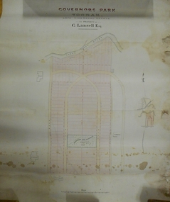
Plan - MARKS COLLECTION: PLAN OF G. LANSELL'S GOVERNOR'S PARK, TOORAK
... of plan Yarra River, on bottom Toorak Road, Plan shows subdivision... of plan Yarra River, on bottom Toorak Road, Plan shows subdivision ...Plan (tightly rolled) drawn on heavy paper mounted on fabric. On top of plan printed 'Governor's Park Toorak, late Vice-Regal Estate, the property of G. Lansell Esq' On top of plan Yarra River, on bottom Toorak Road, Plan shows subdivision, in centre of which is drawn outline of 8 acres containing the 'Mansion and Grounds'.bendigo, hospital -
 Greensborough Historical Society
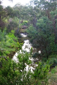
Photograph - Digital Image, Plenty River Greensborough May 2014 -1, 21/05/2014
... meeting with the Yarra River at Rosanna. These images taken... Mt Disappointment before meeting with the Yarra River ...The Plenty River flows south from Mt Disappointment before meeting with the Yarra River at Rosanna. These images taken in the Greensborough area. Photograph by Marilyn Smith 2014.Digital copy of colour photograph.plenty river, greensborough -
 Eltham District Historical Society Inc
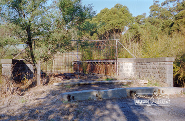
Negative - Photograph, Diamond Creek floodwater at Monash Bridge, Hurstbridge, Dec. 1934
... The historic 1934 flood of the Diamond Creek and Yarra... melbourne The historic 1934 flood of the Diamond Creek and Yarra ...The historic 1934 flood of the Diamond Creek and Yarra River following the storms of 29-30 November set the levels for future planning with respect to flood water rise.This photo forms part of a collection of photographs gathered by the Shire of Eltham for their centenary project book,"Pioneers and Painters: 100 years of the Shire of Eltham" by Alan Marshall (1971). The collection of over 500 images is held in partnership between Eltham District Historical Society and Yarra Plenty Regional Library (Eltham Library) and is now formally known as the 'The Shire of Eltham Pioneers Photograph Collection.' It is significant in being the first community sourced collection representing the places and people of the Shire's first one hundred years.Digital image 4 x 5 inch B&W Negshire of eltham pioneers photograph collection, hurstbridge, 1934 flood, floods, monash bridge, diamond creek (creek) -
 University of Melbourne, Burnley Campus Archives
Plan, Burnley Gardens. City of Richmond. Parish of Jika Jika - County of Bourke, 1927
... , Yarra River to E, Richmond Park on S and W side. Photo...University of Melbourne, Burnley Campus Archives 500 Yarra ...Plan showing Burnley Gardens - bounded by Swan St to N, Yarra River to E, Richmond Park on S and W side. Photo-lithographed at Dept of Lands & Survey by W.J. Butson. Plan shows old orchard, fowl sheds, coops and yards, milking shed, silo,nursery, glasshouse, fattening pens, gardens and orchards area in S.W. corner.burnley gardens, orchards, sheds, nursery -
 Melbourne Tram Museum
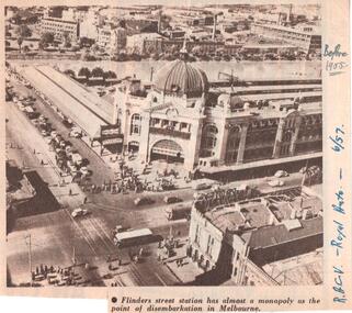
Document - Illustration/s, Royal Automobile club of Victoria (RACv), Jun. 1957
... side of the Yarra River, showing motor cars, trams and one bus... of Flinders St Station and buildings on the south side of the Yarra ...Illustration from the RACV Royal Auto magazine of June 1957 of an aerial view of Flinders St Station and buildings on the south side of the Yarra River, showing motor cars, trams and one bus. Also possibly shows the curve from Swanston St into Flinders St. Caption: "Flinders street station has almost a monopoly as the point of disembarkation in Melbourne"In ink on the side" "RACV - Royal Auto - 6/57 Before 1955"trams, tramways, flinders st station, swanston st -
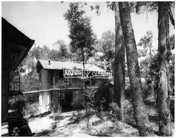 Eltham District Historical Society Inc
Photograph, Exterior of Professor Dick Downing's house - Eltham
... Dick Downing as a weekend house in mud brick on the Yarra river... Dick Downing as a weekend house in mud brick on the Yarra river ...Designed and constructed by Alistair Knox for Dorian Le Galliene, a composer and music critic and his companion Profesor Dick Downing as a weekend house in mud brick on the Yarra river at ElthamThis photo forms part of a collection of photographs gathered by the Shire of Eltham for their centenary project book,"Pioneers and Painters: 100 years of the Shire of Eltham" by Alan Marshall (1971). The collection of over 500 images is held in partnership between Eltham District Historical Society and Yarra Plenty Regional Library (Eltham Library) and is now formally known as 'The Shire of Eltham Pioneers Photograph Collection'. It is significant in being the first community sourced collection representing the places and people of the Shire's first one hundred years.Digital imagesepp, shire of eltham pioneers photograph collection, eltham, professor dick downing, alistair knox, dorian le galliene, house, dwelling, weekender -
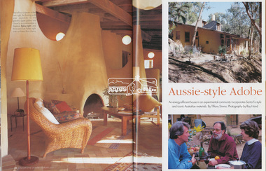 Eltham District Historical Society Inc
Magazine - Magazine Article, FPC Living, Aussie-style Adobe, Country Style, Jan/Feb 2001
... of Islands on the Yarra River. Built of mudbrick, timber... of Islands on the Yarra River. Built of mudbrick, timber ...Articles featuring the home of Carol-Anne and Tom Fisher designed by architect, Ross Henry in Santa-Fe style at Bend of Islands on the Yarra River. Built of mudbrick, timber and corrugated iron.mudbrick, carol-anne fisher, tom fisher, ross henry, santa-fe style, bend of islands, houses -
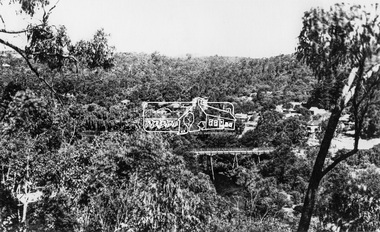 Eltham District Historical Society Inc
Photograph, View at Warrandyte, Vic, c.1937
... township. Taken from the northern side of the Yarra River from near... township. Taken from the northern side of the Yarra River from near ...View looking southeast across the bridge to Warrandyte township. Taken from the northern side of the Yarra River from near present day 244 Research-Warrandyte Rd, North WarrandyteThis photo forms part of a collection of photographs gathered by the Shire of Eltham for their centenary project book,"Pioneers and Painters: 100 years of the Shire of Eltham" by Alan Marshall (1971). The collection of over 500 images is held in partnership between Eltham District Historical Society and Yarra Plenty Regional Library (Eltham Library) and is now formally known as the 'The Shire of Eltham Pioneers Photograph Collection.' It is significant in being the first community sourced collection representing the places and people of the Shire's first one hundred years.Digital image 4 x 5 inch B&W Negshire of eltham pioneers photograph collection, warrandyte, north warrandyte, warrandyte bridge -
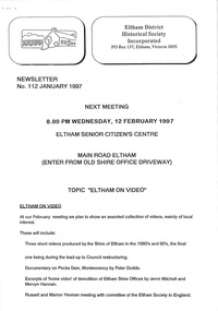 Eltham District Historical Society Inc
Newsletter, Newsletter, No. 112 January 1997
... • The “Shillinglaw Trees” • Yarra River Punt, Warrandyte • Annual General... • The “Shillinglaw Trees” • Yarra River Punt, Warrandyte • Annual General ...Contents: • Next meeting, Eltham on Video • 1997 Program • Former Eltham Shire Office Site – Planning Appeal • The “Shillinglaw Trees” • Yarra River Punt, Warrandyte • Annual General Meeting The Shire of Eltham Historical Society was formed in October 1967. The first newsletter of the Society was issued May 1978 and has been published continuously ever since on a bi-monthly basis. With the cessation of the Shire of Eltham in late 1994, the Society's name was revised to Eltham District Historical Society and this name first appeared with issue No. 103, July 1995. The collection of the Society's newsletters provides a valuable resource on the history of the Society's activities, office bearers and committee members, guest speakers and subjects of historical interest pertinent to the former Shire of Eltham and the Eltham District.A4 photocopied newsletter distributed to membersnewsletter, eltham district historical society, shire of eltham historical society -
 Eltham District Historical Society Inc
Negative - Photograph, Old Lower Plenty Bridge, 18 Apr 1998
... as a footway/bike path section joining the Yarra River path.... as a footway/bike path section joining the Yarra River path. activities ...EDHS Autumn excursion to Lower Plenty area The blocked-off iron bridge at Lower Plenty - now re-opened and used as a footway/bike path section joining the Yarra River path.Roll of 35mm colour negative film, 2 strips and associated colour printKodak Gold 200-6activities, lower plenty bridge, autumn excursion, eltham district historical society, lower plenty -
 Ringwood and District Historical Society
Book, Diane Baird, Digging Into History - Goldmining in Warrandyte, 2007
... on the south side of the Yarra River upstream of the Warrandyte Bridge... battery located on the south side of the Yarra River upstream ...Information about early mining in Victoria's first gold field. Cover photographs: Front cover - Fossickers working below the water-wheen driven stamper battery located on the south side of the Yarra River upstream of the Warrandyte Bridge. Back cover - The Old Post Office, Warrandyte, in 1906, now the premises of the Warrandyte Historical Society Museum and Archive, 111 Yarra Street.Acknowledgements: Several members of the Warrandyte Historical Society were involved in the development of this publication. It was developed and written by Diane Baird; Murray Houghton and Ted Rotherham provided specialist historical details and further references; Jo Laurence and Shirley Rotherham collected and identified photographs; Brian Laurence prepared images for electronic format; and Richard Morton edited and formatted the text. The Society gratefully acknowledges the dedicated work of all its members who collect, preserve and share Warrandyte's history. In particular, the research by the late Bruce Bence and the dedicated work of the late Jo Laurence have been an invaluable contribution to the history of Warrandyte. -
 Dandenong/Cranbourne RSL Sub Branch
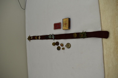
Memorabilia - Small box containing several items
... Yarra river with Melbourne outline in background. Reverse... ( two were produced in gold.) Obverse shows Yarra river ...Various importance.Various small items in box. Includes white metal Centenary of Melbourne Medal 1934 /35. There were 325600 made and issued to school children ( two were produced in gold.) Obverse shows Yarra river with Melbourne outline in background. Reverse sailing ship harbour and whale. Portland was Victoria's first settlement in 1834. Melbourne's settlement with John Batmen a year later.Obverse Centenary Melbourne 1835. Reverse Centenary of Victoria 1834. -
 University of Melbourne, Burnley Campus Archives
Plan, Burnley Gardens. City of Richmond. Parish of Jika Jika - County of Bourke, 1927
... and waterstops. Area bounded by Swan St. To N, Yarra River on E... and waterstops. Area bounded by Swan St. To N, Yarra River on E ...Part-coloured plan showing drainage, sewerage drains, taps and waterstops. Area bounded by Swan St. To N, Yarra River on E and Richmond Park on SW side. Contour lines of orchard depicted, laying pens and yards. Coloured area depicts pavilion with surrounding garden and paths layout pencilled in. Photo-Lithograph by Dept. of Lands & Survey, Melbourne by W. Butsonsewerage, drainage, lithograph, pavilion -
University of Melbourne, Burnley Campus Archives
Plan, Burnley Gardens. City of Richmond. Parish of Jika Jika - County of Bourke, 1927
... , Yarra River to E, Richmond Park on S and W side. Photo...University of Melbourne, Burnley Campus Archives 500 Yarra ...Plan showing Burnley Gardens - bounded by Swan St to N, Yarra River to E, Richmond Park on S and W side. Photo-lithographed at Dept. of Lands & Survey by W.J. Butson. Plan shows old orchard, fowl sheds, coops and yards, milking shed, silo, nursery, glasshouse, fattening pens, dairy, garden, orchards area in S.W. area.burnley gardens, orchards, sheds, nursery -
 Melbourne Tram Museum
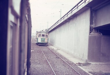
Slide, Keith Caldwell, Mar. 1968
... the tram track and then the Yarra river. Tram 802, West Coburg... the tram track and then the Yarra river. Tram 802, West Coburg ...Agfa colour slide, blue / white plastic mount, photo by Keith Caldwell of a view from a tram southbound in Kingsway section where the road bridge starts to rise to cross over the tram track and then the Yarra river. Tram 802, West Coburg - via William St, route 55 is in the view. Tram has adverts for Tolley's Brandy and ? in Essendon. 3/1968In ink "St K jct 3/68"trams, tramways, kingsway, bridges, route 55, west coburg, tram 802 -
 Melbourne Tram Museum
Photograph - Digital Image, Kevin O'Reilly, Kew Barkers Rd, c1930
... the Yarra River. Has a W class tram, eastbound in Victoria St... towards Victoria Bridge over the Yarra River. Has a W class tram ...Image from CD (Compact Diskette for use in computers) - see Reg Item 135. Image titled "Kew Barkers Rd" on CD, looking west from over Kew Junction towards Victoria Bridge over the Yarra River. Has a W class tram, eastbound in Victoria St, about to cross the bridge. c1930 (Cable conversion late 1929)trams, tramways, kew, barkers rd, victoria st -
 Whitehorse Historical Society Inc.
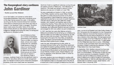
Article - John Gardiner, 23/06/2021
... at the junction of the Yarra River and Kooyongkoot Creek... at the junction of the Yarra River and Kooyongkoot Creek Early pioneer ...John Gardiner was born in Dublin 1798. He was a pastoralist and banker and arrived at Port Phillip in 1836 and with his cousin William Fletcher laid claim to 15,000 acres at the junction of the Yarra River and Kooyongkoot CreekJohn Gardiner was born in Dublin 1798. He was a pastoralist and banker and arrived at Port Phillip in 1836 and with his cousin William Fletcher laid claim to 15,000 acres at the junction of the Yarra and Kooyongkoot Creek.non-fictionJohn Gardiner was born in Dublin 1798. He was a pastoralist and banker and arrived at Port Phillip in 1836 and with his cousin William Fletcher laid claim to 15,000 acres at the junction of the Yarra River and Kooyongkoot Creekgardiner john, gardiners creek -
 Kew Historical Society Inc
Photograph - Yarra Flats near Burke Road Bridge, 1937
... Land along the Yarra River in Kew is now either designated... along the Yarra River in Kew is now either designated open space ...Land along the Yarra River in Kew is now either designated open space, parkland or public golf links. By the 1930s much of this area remained open farmland, bought at auction for dairy farming in the 1840s.Original, black and white positive print of what is said to be the Yarra Flats near Burke Road Bridge. On the horizon, building can be seen, whereas in the middle ground, farm fencing and a windmill are the main features as well as remnant Eucalypts. Inscribed verso: "Yarra Flats near Burke Rd Bridge 1937" studley park -- kew (vic.) -
 Kew Historical Society Inc
Photograph, J F C Farquhar, Railway Bridge Over the Yarra, 1891
... crossed the Yarra River in a single span, atop three supporting... Line. Opened in March 1891, the viaduct crossed the Yarra River ...At the beginning of the 1890s, the Kew businessman and Town Councillor, Henry Kellett, commissioned J.F.C. Farquhar to photograph scenes of Kew. These scenes included panoramas as well as pastoral scenes. The resulting set of twelve photographs was assembled in an album, Kew Where We Live, from which customers could select images for purchase.The preamble to the album describes that the photographs used the ‘argentic bromide’ process, now more commonly known as the gelatine silver process. This form of dry plate photography allowed for the negatives to be kept for weeks before processing, hence its value in landscape photography. The resulting images were considered to be finely grained and everlasting. Evidence of the success of Henry Kellett’s venture can be seen today, in that some of the photographs are held in national collections.It is believed that the Kew Historical Society’s copy of the Kellett album is unique and that the photographs in the book were the first copies taken from the original plates. It is the first and most important series of images produced about Kew. The individual images have proved essential in identifying buildings and places of heritage value in the district.Completed in November 1890, the railway viaduct (now the Chandler Highway Bridge) linked Kew and Fairfield. The viaduct is significant as the most substantial extant engineering remnant of the Outer Circle Railway Line. Opened in March 1891, the viaduct crossed the Yarra River in a single span, atop three supporting brick pillars. Following the closure of the railway line in 1927, and the construction of the Chandler Highway in 1930, the bridge was used for vehicular traffic. In 1891 when this panoramic photograph was taken, the grounds of what was then the Kew Lunatic Asylum extended down to the River and eastward beyond the viaduct. The landscape surrounding the Asylum was planted with traditional exotic trees such as Oaks, Pines and Cedars, and landmark trees from northern Australia such as the Hoop Pine. Remnant indigenous trees such as the River Red Gum, Yellow Box and Lightwood were scattered around the site, including beside the Yarra River.Railway Bridge Over the Yarrakew illustrated, kew where we live, photographic books, henry kellett, railway viaduct - - kew (vic) -
 Wonga Park Community Cottage History Group
Photograph (sub-item) - Black and White, Viewing the camp from across the river at the 1948 Jamboree
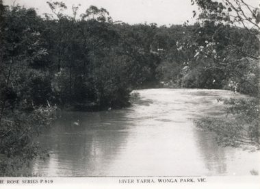
... THE ROSE SERIES P. 919 RIVER YARRA, WONGA PARK ... RIVER YARRA, WONGA PARK Viewing the camp from across the river ...THE ROSE SERIES P. 919 RIVER YARRA, WONGA PARK -
 Seaworks Maritime Museum
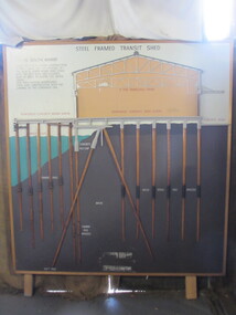
Diagram
... the Yarra river between the 1920s and 1960s. The South Melbourne... along the Yarra river between the 1920s and 1960s. The South ...Cross section of wharves and steel framed sheds built along the Yarra river between the 1920s and 1960s. The South Melbourne side of the Yarra River is reclaimed swamp land. Without a solid foundation for the construction of the wharves and transit sheds, extended piles were sunk into the mud to support the wharf and shed structures. An example of this design may be found at 5 South Wharf which was built in the 1930s. The transit sheds gave shelter for cargo while waiting to be loaded onto a ship or to be collected by truck after being unloaded from a ship. The transit shed became surplus to requirements with the introduction of containers.Wooden diagram of a transit shed featuring a shed sitting atop mud with some water. It shows the splices sitting in the mud to support the shed. "Steel Frames Transit Shed/ 15 South Wharf/ Model of Typical wharf construction/ of 1940- made for the opening of/ the "new" 15 South wharf shed (1944),/ Note the deep piles and elevated/ rear of the shed to allow for the truck/ trays./ This shed feature disappeared/ from port construction with the/ coming of the container era/ reinforced wharf apron/ 3 ton travelling crane/ reinforced concrete shed floor/ concrete road/ water level/ concrete pile cap/ cradled piles/ timber pile splices/ mud/ mild steel pile splices/ 110 ft pile" "On loan from Port of Melbourne Authority" -
Bialik College
Mixed media (Item) - 2008_2009 Prep K and Grade 1, Prep K and Grade 1 photos, 2008_2009
... Keeper's of the River project, focusing on the Yarra River...Keeper's of the River project, focusing on the Yarra River ...Keeper's of the River project, focusing on the Yarra River, Melbourne Naarm, showing 'our connections with our community' project by Prep and Grade 1K at Bialik College, 2009. Please contact [email protected] to request access to this record.Our Journey Together Prep K '08 Year 1K '09grade 1, prep, 2000s, 2009, bialik college, primary school -
 Marysville & District Historical Society
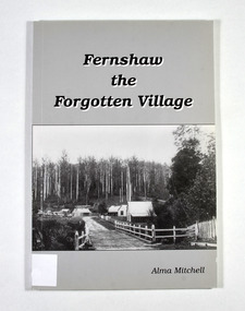
Book - Paperback book, Alma Mitchell, Fernshaw the Forgotten Village, 2001
... river yarra track The story of the village of Fernshaw between ...The story of the village of Fernshaw between the dates of 1864 and 1890.Paperback. Front cover has the title and author's name. Also, a black and white photograph taken by John W. Lindt entitled 'First Glimpse of Fernshaw'.non-fictionThe story of the village of Fernshaw between the dates of 1864 and 1890.fernshaw, victoria, history, watts river, yarra track -
 Marysville & District Historical Society
Book - Paperback book, Alma Mitchell, Fernshaw the Forgotten Village, 2001
... river yarra track The story of the village of Fernshaw between ...The story of the village of Fernshaw between the dates of 1864 and 1890.Paperback. Front cover has the title and author's name. Also, a black and white photograph taken by John W. Lindt entitled 'First Glimpse of Fernshaw'.non-fictionThe story of the village of Fernshaw between the dates of 1864 and 1890.fernshaw, victoria, history, watts river, yarra track -
![Photographs [Series], Noel Kelly, Chandler Highway Bridge Construction, 11/07/2018](/media/collectors/550653872162f11fb04854aa/items/5c2f52bd21ea670d20783d9e/item-media/5c2f53b221ea670d2079233e/item-fit-380x285.jpg) Kew Historical Society Inc
Kew Historical Society IncPhotographs [Series], Noel Kelly, Chandler Highway Bridge Construction, 11/07/2018
... railway viaduct - river yarra... chandler highway bridge noel kelly railway viaduct - river yarra ...A selection of photographs taken in July/August 2018 recording work on the old and new Chandler Highway Bridges.chandler highway bridge, noel kelly, railway viaduct - river yarra -
 Kew Historical Society Inc
Photograph - Crossing Dights' Falls on the Yarra by foot
... River Yarra -- Kew - Abbotsford.... Dight's falls River Yarra -- Kew - Abbotsford Reverse: "M Holmes ...Dight’s Falls in Studley Park is an artificial weir built on a natural rock bar across the Yarra. The weir was built in the 1840s to provide water to the ‘Ceres’ flour-mill, one of the first in Victoria. The falls were later to become known as Dight’s Falls after the owners of the mill. Later, a pumping station was built on the Kew side of the river, which pumped water uphill to a reservoir in Walmer Street that provided water to the Melbourne Botanical Gardens and to Albert Park Lake. The area around Dight’s Falls was and is frequently used for recreational activities.Rare original print photograph of people walking across Dight's Falls when the river flow was low. View west towards Abbotsford. Photograph taken from Kew side of river above the Falls.Reverse: "M Holmes"dight's falls, river yarra -- kew - abbotsford -
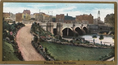 Kew Historical Society Inc
Postcard, Princess Bridge, Melbourne, c.1907
... river yarra...-east bank of the Yarra River, looking towards the city ...The Kew Historical Society's postcard collection includes views of Kew, Melbourne and Greater Melbourne as well as those including overseas scenes sent or received from Europe or the Middle East. They date from the 1890s to the 2000s. These postcards may or may not include the name of the publisher or printer. A number of the cards were published as parts of popular series. A way of dating early postcards is to identify whether the reverse was divided by a central line which became the norm after 1902 in the United Kingdom. However, other postcards produced after this date do not always conform to this print layout.Rare variant version of this view of Princes Bridge, from the south-east bank of the Yarra River, looking towards the city of Melbourne, showing landmarks of the period.Polychrome postcard of Princess Bridge in Melbourne.Princess Bridge, Melbourne Miss McGilivray, "Oak Bank", Peterborough, _____. princess bridge -- melbourne (vic.), river yarra, postcards -- melbourne (vic.) -
 Kew Historical Society Inc
Photograph, Burke Road Bridge, 1930s
... bridges -- river yarra...) bridges -- river yarra Sepia, faded photograph of the Burke Road ...Without bridges, Kew remained cut off from the City of Melbourne, only being accessible by Punt. Private and public bridges were constructed from the 1850s, beginning with the Hawthorn Bridge linking Bridge and Burwood Roads. A bridge across the Yarra at Burke Road was created as early as 1873. Since that first wooden bridge, a number of later bridges, typically on concrete pylons have been built, in 1926 and again during the 1970s.Sepia, faded photograph of the Burke Road Bridge linking East Kew and Ivanhoe. The previous bridge, constructed in 1926 was submerged beneath the flood waters in the 1934 mega-flood of the Yarra.burke road bridge (kew), bridges -- river yarra -
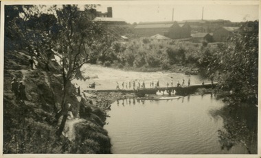
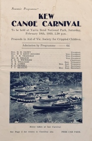 Kew Historical Society Inc
Programme, Kew Canoe Carnival, 1939
... recreation -- river yarra.... kew canoe carnivals recreation -- river yarra christian ...An item from an outstanding and diverse photographic collection, assembled by members of the Christian and Washfold families of Kew.10-page souvenir programme for the Kew Canoe Carnival to be held at Yarra Bend National Park on Saturday February 18th, 1939. Proceeds were designed to assist the Victorian Society for Crippled Children. Front cover shows photograph taken at the previous year's carnival. The site of the carnival shown on an internal map was upriver from Macauley's boat house. Photograph on back cover shows canoeists at Kew Boat Sheds, 45 Molesworth Street.kew canoe carnivals, recreation -- river yarra, christian-washfold collection -
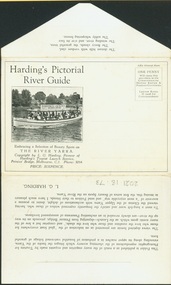 Kew Historical Society Inc
Postcard, Melbourne Ferries Pty Ltd, Harding's Pictorial River Guide
... river yarra -- tourism... cruises river yarra -- tourism harding's boat cruises christian ...One of a number of 'real photo' and commercial postcards created by or owned by members of the Christian and Washfold families of Kew. The postcards are part of a larger collection of photographs, postcards and publications donated to the collection in May 2021.Postcard folder. Selection of ‘beauty spots’ along Yarra between Princes Bridge and Heidelberg via Studley Park. Boat advertises Harding’s Launches Studley Park & Heidelberg. Pictured boat is ‘25 Canberra’.harding's river cruises, river yarra -- tourism, harding's boat cruises, christian-washfold collection