Showing 22369 items matching "parks"
-
 Bendigo Military Museum
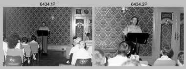
Photograph - Army Survey Regiment Open Day - Briefings and Tours, Fortuna, Bendigo, 1990
These 27 photographs were taken at an Army Survey Regiment Open Day at Fortuna Villa, Bendigo on the 24th of February 1990. This occasion was one of several events held to commemorate the 75th anniversary of the formation of the Royal Australian Survey Corps. Although historical tours of Fortuna occurred on a regular basis, this was the first technical open day since 1972. The Royal Australian Survey Corps recognised that an Open Day was the best way for the local community in Bendigo to gain an insight into the unit’s important role as Defence’s map production agency, its technical equipment, and its economic importance to Bendigo. It also gave them an opportunity to tour through historic Fortuna Villa. This occasion is covered in more detail in page 143 of Valerie Lovejoy’s book 'Mapmakers of Fortuna – A history of the Army Survey Regiment’ ISBN: 0-646-42120-4. Refer to items 6435.35P and 6436.18P for more photos of the Open Day taken in the Map Production areas of Air Survey and Cartographic Squadron, and production areas of Lithographic Squadron. Photo prints of some of these photos were scanned and catalogued in items 6247.30P and 6291.6P.These 27 photographs were taken at an Army Survey Regiment Open Day held at Fortuna, Bendigo on the 24th of February 1990. The 35mm colour and black & white negatives photographs were scanned at 96 dpi and are part of the Army Survey Regiment’s Collection. .1) & .2) - Photo, black & white, 1990. Ballroom - Visitor briefings by CO LTCOL Rene van den Tol. .3) - Photo, colour, 1990. Ballroom - Visitor briefings by MAJ Ray Redman. .4) - Photo, colour, 1990. Ballroom - Visitor briefings by unidentified UK Exchange officer. .5) - Photo, black & white, 1990. Music Room - Visitor briefings by MAJ Bob Williams. .6) - Photo, black & white, 1990. Orderly Room - ADJT CAPT Peter Parkes. .7) - Photo, colour, 1990. Music Room - ADJT CAPT Peter Parkes with civilian visitors. .8) - Photo, colour, 1990. Music Room - Visitor briefings by CPL Le-Anne (Smallshaw) Shirley. .9) - Photo, colour, 1990. Entrance Foyer - Visitor briefings. .10) - Photo, colour, 1990. CO’s Office - Visitor briefings by CPL Raelene (Munting) Brodie. .11) - Photo, colour, 1990. Mr Pat Thwaites outlining utilisation of satellite imagery to civilian visitors. .12) - Photo, black & white, 1990. Mr Pat Thwaites outlining utilisation of satellite imagery to civilian visitors. .13) - Photo, colour, 1990. Staircase leading up to the top floor - Visitor briefings by CPL Ian Nelson. .14) - Photo, colour, 1990. Building 16 - Visitor briefings by RSM WO1 Neville Stone. .15) - Photo, colour, 1990. Civilian visitors enjoying views of the garden from Fortuna Villa’s rooftop. .16) - Photo, black & white, 1990. Visitor briefings at Fortuna’s rear steps. .17) - Photo, black & white, 1990. Outside Building 16 - Visitor briefings by WO1 Gary Warnest. .18) - Photo, colour, 1990. Outside Building 16 - Visitor briefings by WO2 Adrian ‘Charlie’ Creedy. .19) - Photo, colour, 1990. Outside Building 16 - L to R: SPR Sue (Foote) Bourne, LCPL Sandy Winn, WO2 Adrian ‘Charlie’ Creedy. .20) - Photo, colour, 1990. Outside Building 16 - SGT Greg Byers. .21) - Photo, colour, 1990. Visitors enjoying Devonshire Tea in the gardens next to the Tavern. .22) - Photo, colour, 1990. RSM WO1 Neville Stone and family enjoying Devonshire Tea in the gardens next to the Tavern. .23) - Photo, colour, 1990. Visitors relaxing in the garden next to Fortuna’s lake. .24) - Photo, black & white, 1990. CPL Trevor Poll and others serve up BBQ lunch next to the tennis courts. .25) to .27) - Photo, colour, 1990. Parking at a premium inside the Army Survey Regiment and Chum Street..1P to .27P – no annotationsroyal australian survey corps, rasvy, army survey regiment, army svy regt, fortuna, asr -
 Bendigo Military Museum
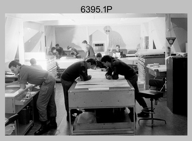
Photograph - Army Survey Regiment – Map Production, Fortuna, Bendigo, 1986
These 17 photographs of the Army Survey Regiment’s map production and facilities were taken at Fortuna Villa, Bendigo, April 1986. Photos .1P to .3P were taken in Cartographic Squadron’s Correcting Section in the Attic. located on the top floor of Fortuna Photos .4P to .5P were taken in Cartographic Squadron’s Proving Section, located in the Ballroom also on the top floor facing the lake. The technicians were probably involved in a rapid response map production, as they all were wearing field uniforms. As ‘Regiment Overcrowding’ is annotated on the plastic sleeve holding the negatives, it seems the photos were taken when the unit was at its capacity to demonstrate the lack of suitable work areas. The Army Survey Regiment’s Duty Room, RAP and Carpark appearing in Photo .10P was probably taken from the top steps near the SGT’s accommodation block. Two of the photos in this set are also published in item 6096.5P.This is a set of 17 photograph of Map Production and car park was taken at the Army Survey Regiment, Fortuna, Bendigo, in April 1986. The black & white photographs are on 35mm negative film and are part of the Army Survey Regiment’s Collection. The photographs were scanned at 96 dpi. .1) - Photo, black & white, 1986. Correcting Section, Attic: L to R: CPL Andy Lucas, SPR Chris Gordon, unidentified, SPR Jan (Crighton) Minchin, CPL Robin Marshall, CPL Frank Downie, SPR Gayle Humphrey, unidentified (x2), Jason Wells at rear. .2) - Photo, black & white, 1986. Correcting Section, Attic: L to R: CPL Andy Lucas, SPR Chris Gordon, unidentified, SPR Jan (Crighton) Minchin, CPL Robin Marshall, CPL Frank Downie, SPR Gayle Humphrey, unidentified, Jason Wells, unidentified. .3) - Photo, black & white, 1986. Correcting Section, Attic: L to R: CPL Andy Lucas, CPL Robin Marshall, SPR Chris Gordon, unidentified, CPL Frank Downie, SPR Gayle Humphrey, unidentified, SPR Jan (Crighton) Minchin at rear., Jason Wells on phone. .4) & .5) - Photo, black & white, 1986. Proving Section, Ballroom: On left front to back: SGT Alan Staley, SGT Roger Rees, SGT Greg Anderson. On right front to back: SGT Denis McCarthy, SGT Tim Allanson, SSGT Adrian ‘Charlie’ Creedy. .6) - Photo, black & white, 1986. Records & Proofing buildings. .7) - Photo, black & white, 1986. Technical Services temporary buildings. .8) - Photo, black & white, 1986. Q-store and transport buildings. .9) - Photo, black & white, 1986. Technical Services temporary buildings in front of transport compound. .10) - Photo, black & white, 1986. Army Survey Regiment Duty Room, RAP and Carpark at Fortuna. .11) - Photo, black & white, 1986. Records & Proofing buildings. .12) - Photo, black & white, 1986. Other Ranks (OR’s) car park and barracks with kitchen in background. .13) - Photo, black & white, 1986. Other Ranks kitchen, parade ground and SGT’s/Officers barracks in background. .14) - Photo, black & white, 1986. Fortuna Villa taken from the steps near the SGT’s accommodation block. .15) - Photo, black & white, 1986. Fortuna Villa taken from the steps near the OR’s s accommodation block. .16) - Photo, black & white, 1986. Fortuna Villa taken from the roadway near the OR’s accommodation block. .17) - Photo, black & white, 1986. 20’ x 30’ Army tents set up on the basketball court..1P to .17P – ‘Regiment Overcrowding’ and the date are annotated on the plastic sleeve.royal australian survey corps, rasvy, army survey regiment, army svy regt, fortuna, asr -
 Marysville & District Historical Society
Postcard (item) - Colour postcard, Nucolorvue Productions Pty. Ltd, Marysville-Victoria, Pre 2009
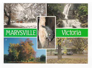
A postcard with 5 colour photographs of local attractions in and around Marysville in Victoria.A postcard with 5 colour photographs of local attractions in and around Marysville in Victoria. This postcard was produced by Nucolorvue Productions as a souvenir of Marysville.MARYSVILLE/ Victoria 1. Burrengeen Park in Winter./ 2. Steavenson Falls./ 3. Autumn tonings of Marysville./ 4. Olde Yarra Track Shoppe./ 5. Mountain Grey (Brushtail) Possum. NU-COLOR-VUE/ OF/ AUSTRALIA AFFIX/ STAMP/ HERE/ 18 MA002/ NCV 5408 ADDRESS/ POSTCODE Made in Australia Date Stamp MARYSVILLE VIC AUST DEAR MELISSA,/ HERE IT IS MELISA/ YOUR OWN CARD AS/ REQUESTED. I AM/ RELAXING IN FRONT OF/ A HUGE LOG FIRE AT/ THE MOMENT BEFORE/ ATTACKING A 4 COURSE/ MEAL FOR TEA. I/ HAVE SETTLED IN TO/ THIS WAY OF LIFE/ ALREADY AND AM THROUGH/ LY ENJOYING IT. LOTS/ OF PAINTING MATERIAL/ AROUND HERE TOO. HEATED/ POOL (SALT) IS BEAUT./ SEE YOU LATER/ Jess xx M/S MELISA THOMSON/ C/- COCA-COLA BOTTLERS/ 128 BRIENS RD/ NORTHMEAD 2152/ SYDNEY/ N.S.W. COPYRIGHT/ Nucolorvue Productions Pty. Ltd. Telephone: (03) 560-1788marysville, victoria, burrengeen park, steavenson falls, autumn, yarra track, mountain grey possum, brushtail possum, nucolorvue productions, postcard, souvenir -
 Clunes Museum
Photograph - DEBUTANTE PHOTOGRAPH
.1 CLUNES TENNIS CLUB DEBUTANTE BALL 22ND AUGUST 1986, DEBS AND PARTNERS .2 CLUNES TENNIS CLUB DEBUTANTE BALL 1986 OFFICIAL PARTY .3 TENNIS CLUB DEB BALL , DATE UNKNOWN DEBUTANTES ONLY .4 EIGHT LADIES IN EVENING GOWNS..1 ON BACK: CLUNES TENNISCLUB DEBUTANTE BALL 22ND AUGUST 1986 BACK ROW: JOHN HIND, ADAM PARR, PAUL PARDOEL,SCOTT CAMERON, MARK ANDREWS, JAMIE ANDREWS, DOUGGARTH SECOND BACK:NEIL RUMLER,PETER WITCHER, WAYNE STEPMALL, HOWARD SMITH, ROD SALKOVIC, WAYNE WESTCOMBE, ROB POLLACK GIRLS STANDING:JULIE CHANT, LIZ HARRISON, PENNY MITCHELL, KIM VAN BERKEL,ANDREA MCFARLANE, CHRISTINEDUNNE, KAREN SOBIE SITTING:JODIE JOBUNG, KATRINA WILLIAMS, , KERRY NUGENT, ANNITA PARKS, AMBER JESSER, ROBIN GOLDSMITH, PAGE BOY DANNY ANDREWS, FLOWER GIRL RACHEL NUGENT .2 OFFICIAL PARTY: ALLAN BARTLEY, MARIE BARTLEY, BARB ADAMS, CATHIE KELLER, PETER KELLER .2 OFFICIAL PARTY ALLEN BARTLEY, MARIE BARTLEY, BARB ADAM, CATHIE KELLER, PETER KELLER .3 JENNY HILL,, COLLINS , BARB ADAM, KAYE SADOWITH , GEOFF MILLER .4 NOT A DEB BALL debutante ball 1968, tennis club -
 Ballarat Tramway Museum
Document - Report, Melbourne and Metropolitan Tramways Board (MMTB), MMTB Reports 1970 to 1976, 1970 to 1976
Seven copies of the Annual report of the MMTB for the years end 1970 to 1976. 3951.1 - "Report and Statement of Accounts for year ended 30 June 1970", No. 51, gloss fawn heavy paper cover with 44 pages, gloss, on inside giving details of the MMTB Board, Officers, Balance Sheet, Statement of operations, schedule of debenture, investments, Auditors reports, record of Annual traffic receipts, passengers, miles etc, tram and bus routes operated, statistical information, graphs and photographs. Photos include Doncaster depot, track reconstruction - concrete spreading equipment, Wattle Park and tram wheel grinding equipment. No printer name given. 3951.2 - "Report and Statement of Accounts for year ended 30 June 1971", No. 52, white embossed heavy paper cover with 44 pages, gloss, on inside giving details of the MMTB Board, Officers, Balance Sheet, Statement of operations, schedule of debenture, investments, Auditors reports, record of Annual traffic receipts, passengers, miles etc, tram and bus routes operated, statistical information, graphs and photographs. Photos include; prototype tram in St Kilda Rd, the New computer installation, decorated tram - Christmas 1970, Tram Advertising 1971 (briquettes), No printer name given. 3951.3 - "Annual Report 1972" - white gloss heavy paper cover with 44 pages, gloss, on inside giving details of the MMTB Board, Officers, Operations report, schedule of debenture, investments, Auditors reports, record of Annual traffic receipts, passengers, miles etc, tram and bus routes operated, statistical information, graphs and photographs. Photos include; school children boarding bus, passengers boarding bus at Shoppingtown, Concreting tracks in Keilor Road, Rail Inspection Unit and Wattle Park. No printer name given. 3951.4 - "Annual Report 1973" - light grey gloss heavy paper cover with 40 pages, gloss, on inside giving details of the MMTB Board, Officers, Operations report, schedule of debenture, investments, Auditors reports, record of Annual traffic receipts, passengers, miles etc, tram and bus routes operated, statistical information, graphs and photographs. Photos include; tram 1041, interior and driving cabin of 1041 and fire fighting demonstration at Preston Workshops. No printer name given. 3951.5 - "Annual Report 1974" - light blue gloss heavy paper cover with 40 pages, gloss, on inside giving details of the MMTB Board, Officers, Operations report, schedule of debenture, investments, Auditors reports, record of Annual traffic receipts, passengers, miles etc, tram and bus routes operated, statistical information, graphs and photographs. Photos include; Pedestrian Mall, Bourke St, New truck assembly area at Preston Workshops, electronic control equipment for new trams, English language lessons for migrant employees and 1041 turning from Bourke into Spring St. Printed by Sands & McDougall. 3951.6 - "Annual Report 1975" - fawn coloured gloss heavy paper cover with 44 pages, gloss, on inside giving details of the MMTB Board, Officers, Operations report, schedule of debenture, investments, Auditors reports, record of Annual traffic receipts, passengers, miles etc, tram and bus routes operated, statistical information, graphs and photographs. Photos include; Z class tram in Nicholson St, National Bus in Doncaster, New passenger shelter in St Kilda Road, new trams at Preston, drivers position of Z class tram, Interior of National Bus, Drivers position in National bus and first cable car in Melbourne after restoration. Printed by Magnum Press. 3951.7 - "Annual Report 1976" - light blue coloured gloss heavy paper cover with 44 pages, gloss, on inside giving details of the MMTB Board, Officers, Operations report, schedule of debenture, investments, Auditors reports, record of Annual traffic receipts, passengers, miles etc, tram and bus routes operated, statistical information, graphs and photographs. Photos include; Z2 in Bourke St, Z24 Victoria Parade, Z17 Nicholson St, overhead trucks, W2 in Mount Alexander Road Nth Essendon, Z28 Nicholson St, W2 226 loading passengers St Georges Rd and Wattle Park. Printed by Magnum Press.3951.1 - has Graeme Breydon's address stamp on front cover., 3951.2 - ditto, 3951.3 - ditto and on inside of front cover., 3951.6 - "G. Breydon" in pencil on front cover and pencil comments on balance sheet., 3951.7 - dittotrams, tramways, mmtb, melbourne, annual reports, operations, trackwork -
 Eltham District Historical Society Inc
Photograph, Peter Pidgeon, Graves of Mary Josephine Swallow, John Swallow (unmarked) and Patricia Catherine Hill, Eltham Cemetery, Victoria, 5 April 2021
On the 29th of May 1954, a local Eltham carpenter by the name of John Swallow, committed a double murder at his home on New Street. This happened on the same day as the federal election of that year. John 48, his wife Mary 47, and stepdaughter Patricia 25, all went to the Eltham Courthouse on Main Road to cast their vote in the election that Saturday. After voting they returned home to their New Street house around midday. Patricia would later recall to ambulance officers, that she was feeling unwell, and so went to lay down when she heard an argument erupt over voting between her mother Mary and stepfather John. A concerned neighbour heard loud thudding noises and yelling coming from John and Mary’s house, he went to investigate. When he arrived at the house he was met by John at the front door. He would later describe John as “having a frantic look upon his face, and manic eyes”. John must have been a sight, bleeding and clutching a cut throat razor by his side. He then announced to the neighbour, “they voted commie!” before turning and going back inside. The distressed neighbour immediately raced home to call the Police. When the police arrived, they found Mary dead on the kitchen floor from catastrophic head injuries; her daughter, Patricia, clinging to life, slumped on her bed. Both women had been attacked by the same weapon, a large hammer, or sledge hammer as reported by the newspapers. John was also discovered in the house, bleeding from self-inflicted wounds from the razor, and had attempted to ingest caustic soda. Patricia was taken to St Vincent’s hospital, but died the following day, the 30th of May. John was also taken to St Vincent’s, where he remained under constant police guard for several months while he recovered from his injuries, at least the physical. He was eventually well enough to be taken to the City Watch House and then Pentridge Prison before his trial in October of the same year. When it came time for John to face the courts, the Judge called a mistrial, the Crown would not prosecute on the grounds of insanity. John was led away from the dock of The Magistrates Court and taken directly to Willsmere, the Kew Mental Asylum. On the 9th of August 1962, John Mervyn Swallow died of heart failure, he was 57. He had been a resident of Kew for four years. John’s body was returned to Eltham Cemetery and buried in the same grave as Mary. There is no mention of his name on the head stone. Patricia’s grave is next to Mary and John. A sad irony has an angel upon her grave, “its head missing”, possibly vandals or just an accident of time and events. What became of the home where all of this took place on New Street shall remain a mystery but within six months of this horrific event, the street had been re-named to Lavender Park Road after the original property near the end of the road, Lavender Park. In Memory Of Mary Josephine Swallow Died 29th May 1954 aged 47 Also Patricia Cathryn Hill Dearly beloved wife of Kel Called home 30th May 1954 Aged 25 yearsBorn Digitaleltham cemetery, gravestones, mary josephine swallow, patricia catherine hill, john swallow -
 Eltham District Historical Society Inc
Photograph, Upper Yarra Dam, Spring Tour, 22 Oct 1995, 22/10/1995
EXPLORING THE UPPER YARRA (Newsletter No. 105, November 1995, by Bettina Woodburn) We enjoyed the Spring Excursion, this year "Exploring the Upper Yarra" - in spite of the constant rain and the countryside under the cloud cover, especially in the valleys, being mainly shiny shades of green. The occasional fields of buttercups, clumps of arum lilies and splendid rhododendron and other flowering bushes became very special. The Cobb and Co coach was warm and a cosy retreat as we zig-zagged on the highways and byways to glimpse the Yarra River, upstream and down, its secret places, and particularly the many bridges. Russell excelled as 'Poet Laureate', reading from Dacre Smyth's book. This 1979 publication includes paintings of all the bridges along the river with poems and brief descriptions of each one. Some of the bridges are in out of the way places and are not very well known. We looked forward to hearing the poetry as much as seeing the ' constructions'…Big Pat (was he short or tall, lean or fat? He did win the two hundred pound reward for discovering gold and had the creek named after him), about the 'Eddies'?, and the disliked 'meccano' bridge in Warburton, etc. etc. The hot roast lunch in the old Reefton Hotel was also most welcome. It was easy to imagine it peopled by miners and early settlers. Starting by crossing the new (1974) concrete bridge at Warrandyte we headed through Wonga Park with views to the Christmas Hills and to the escarpment of the Yering Gorge, which causes flood waters to back up through the Yarra Glen plain, so avoiding disasters downstream. At the end of a long driveway we found the wooden, privately owned Henley Bridge (1935 after the 1934 floods). This facilitates access to different parts of Henley Farm and to Lilydale. Everard Park, named after Blanche Shallard's father, a State Member for 17 years, below the Highway Yarra crossing was in need of care. It is 10 miles from Yarra Glen by road but, as "Yarra Marra” canoeists well know, 32 winding miles down by water. After more delightful countryside scenes we joined the Warburton Highway at Woori Yallock. From the old Railway Station at Launching Place the Centennial Trail for walkers, cyclists and ' horse riders has replaced the rails. The line from Lilydale was opened in 1901, and the last diesel freight train ran to Warburton in 1965. It continued to rain as we had morning tea in Warburton in a shelter between footbridges. From here we continued upstream past the Bridge to O'Shannasy Lodge and Reservoir, Starvation Creek, and the Peninsular tunnel (miners dug it as at Pound Bend) which we visited (scrambling down those steps!) on our return after lunch. Our furthermost point was the Upper Yarra Dam Reserve (and vast catchment area). Finished in 1957 after ten years work and 100 years after Yan Yean, it supplies much of Melbourne's water. After crossing the 30m Launching Place Bridge to the Eltham side of the Yarra and Healesville, we saw in the distance the Yarra Glen Timber Trestle Bridge over the river flats "the longest for years in the land it was said!" Harry's dream of "better weather over the Divide" unfortunately didn't come true, but I'm sure we 36 members will retain happy memories of a day that was wet and green and filled with Bridges. Bettina Woodburn - October 1995 Record of the Society's history of activities - Spring 1995 excursionColour photographshire of eltham historical society, activities, upper yarra dam, henley bridge -
 Eltham District Historical Society Inc
Photograph, Upper Yarra Dam, Spring Tour, 22 Oct 1995, 22/10/1995
EXPLORING THE UPPER YARRA (Newsletter No. 105, November 1995, by Bettina Woodburn) We enjoyed the Spring Excursion, this year "Exploring the Upper Yarra" - in spite of the constant rain and the countryside under the cloud cover, especially in the valleys, being mainly shiny shades of green. The occasional fields of buttercups, clumps of arum lilies and splendid rhododendron and other flowering bushes became very special. The Cobb and Co coach was warm and a cosy retreat as we zig-zagged on the highways and byways to glimpse the Yarra River, upstream and down, its secret places, and particularly the many bridges. Russell excelled as 'Poet Laureate', reading from Dacre Smyth's book. This 1979 publication includes paintings of all the bridges along the river with poems and brief descriptions of each one. Some of the bridges are in out of the way places and are not very well known. We looked forward to hearing the poetry as much as seeing the ' constructions'…Big Pat (was he short or tall, lean or fat? He did win the two hundred pound reward for discovering gold and had the creek named after him), about the 'Eddies'?, and the disliked 'meccano' bridge in Warburton, etc. etc. The hot roast lunch in the old Reefton Hotel was also most welcome. It was easy to imagine it peopled by miners and early settlers. Starting by crossing the new (1974) concrete bridge at Warrandyte we headed through Wonga Park with views to the Christmas Hills and to the escarpment of the Yering Gorge, which causes flood waters to back up through the Yarra Glen plain, so avoiding disasters downstream. At the end of a long driveway we found the wooden, privately owned Henley Bridge (1935 after the 1934 floods). This facilitates access to different parts of Henley Farm and to Lilydale. Everard Park, named after Blanche Shallard's father, a State Member for 17 years, below the Highway Yarra crossing was in need of care. It is 10 miles from Yarra Glen by road but, as "Yarra Marra” canoeists well know, 32 winding miles down by water. After more delightful countryside scenes we joined the Warburton Highway at Woori Yallock. From the old Railway Station at Launching Place the Centennial Trail for walkers, cyclists and ' horse riders has replaced the rails. The line from Lilydale was opened in 1901, and the last diesel freight train ran to Warburton in 1965. It continued to rain as we had morning tea in Warburton in a shelter between footbridges. From here we continued upstream past the Bridge to O'Shannasy Lodge and Reservoir, Starvation Creek, and the Peninsular tunnel (miners dug it as at Pound Bend) which we visited (scrambling down those steps!) on our return after lunch. Our furthermost point was the Upper Yarra Dam Reserve (and vast catchment area). Finished in 1957 after ten years work and 100 years after Yan Yean, it supplies much of Melbourne's water. After crossing the 30m Launching Place Bridge to the Eltham side of the Yarra and Healesville, we saw in the distance the Yarra Glen Timber Trestle Bridge over the river flats "the longest for years in the land it was said!" Harry's dream of "better weather over the Divide" unfortunately didn't come true, but I'm sure we 36 members will retain happy memories of a day that was wet and green and filled with Bridges. Bettina Woodburn - October 1995 Record of the Society's history of activities - Spring 1995 excursionRoll of 35mm colour negative film, 3 stripsKodak Gold 200-4shire of eltham historical society, activities, upper yarra dam, henley bridge -
 Eltham District Historical Society Inc
Photograph, Upper Yarra Dam, Spring Tour, 22 Oct 1995, 22/10/1995
EXPLORING THE UPPER YARRA (Newsletter No. 105, November 1995, by Bettina Woodburn) We enjoyed the Spring Excursion, this year "Exploring the Upper Yarra" - in spite of the constant rain and the countryside under the cloud cover, especially in the valleys, being mainly shiny shades of green. The occasional fields of buttercups, clumps of arum lilies and splendid rhododendron and other flowering bushes became very special. The Cobb and Co coach was warm and a cosy retreat as we zig-zagged on the highways and byways to glimpse the Yarra River, upstream and down, its secret places, and particularly the many bridges. Russell excelled as 'Poet Laureate', reading from Dacre Smyth's book. This 1979 publication includes paintings of all the bridges along the river with poems and brief descriptions of each one. Some of the bridges are in out of the way places and are not very well known. We looked forward to hearing the poetry as much as seeing the ' constructions'…Big Pat (was he short or tall, lean or fat? He did win the two hundred pound reward for discovering gold and had the creek named after him), about the 'Eddies'?, and the disliked 'meccano' bridge in Warburton, etc. etc. The hot roast lunch in the old Reefton Hotel was also most welcome. It was easy to imagine it peopled by miners and early settlers. Starting by crossing the new (1974) concrete bridge at Warrandyte we headed through Wonga Park with views to the Christmas Hills and to the escarpment of the Yering Gorge, which causes flood waters to back up through the Yarra Glen plain, so avoiding disasters downstream. At the end of a long driveway we found the wooden, privately owned Henley Bridge (1935 after the 1934 floods). This facilitates access to different parts of Henley Farm and to Lilydale. Everard Park, named after Blanche Shallard's father, a State Member for 17 years, below the Highway Yarra crossing was in need of care. It is 10 miles from Yarra Glen by road but, as "Yarra Marra” canoeists well know, 32 winding miles down by water. After more delightful countryside scenes we joined the Warburton Highway at Woori Yallock. From the old Railway Station at Launching Place the Centennial Trail for walkers, cyclists and ' horse riders has replaced the rails. The line from Lilydale was opened in 1901, and the last diesel freight train ran to Warburton in 1965. It continued to rain as we had morning tea in Warburton in a shelter between footbridges. From here we continued upstream past the Bridge to O'Shannasy Lodge and Reservoir, Starvation Creek, and the Peninsular tunnel (miners dug it as at Pound Bend) which we visited (scrambling down those steps!) on our return after lunch. Our furthermost point was the Upper Yarra Dam Reserve (and vast catchment area). Finished in 1957 after ten years work and 100 years after Yan Yean, it supplies much of Melbourne's water. After crossing the 30m Launching Place Bridge to the Eltham side of the Yarra and Healesville, we saw in the distance the Yarra Glen Timber Trestle Bridge over the river flats "the longest for years in the land it was said!" Harry's dream of "better weather over the Divide" unfortunately didn't come true, but I'm sure we 36 members will retain happy memories of a day that was wet and green and filled with Bridges. Bettina Woodburn - October 1995 Record of the Society's history of activities - Spring 1995 excursionRoll of 35mm colour negative film, 2 stripsKodak Gold 100-4shire of eltham historical society, activities, upper yarra dam, henley bridge -
 Eltham District Historical Society Inc
Photograph, Upper Yarra Dam, Spring Tour, 22 Oct 1995, 22/10/1995
EXPLORING THE UPPER YARRA (Newsletter No. 105, November 1995, by Bettina Woodburn) We enjoyed the Spring Excursion, this year "Exploring the Upper Yarra" - in spite of the constant rain and the countryside under the cloud cover, especially in the valleys, being mainly shiny shades of green. The occasional fields of buttercups, clumps of arum lilies and splendid rhododendron and other flowering bushes became very special. The Cobb and Co coach was warm and a cosy retreat as we zig-zagged on the highways and byways to glimpse the Yarra River, upstream and down, its secret places, and particularly the many bridges. Russell excelled as 'Poet Laureate', reading from Dacre Smyth's book. This 1979 publication includes paintings of all the bridges along the river with poems and brief descriptions of each one. Some of the bridges are in out of the way places and are not very well known. We looked forward to hearing the poetry as much as seeing the ' constructions'…Big Pat (was he short or tall, lean or fat? He did win the two hundred pound reward for discovering gold and had the creek named after him), about the 'Eddies'?, and the disliked 'meccano' bridge in Warburton, etc. etc. The hot roast lunch in the old Reefton Hotel was also most welcome. It was easy to imagine it peopled by miners and early settlers. Starting by crossing the new (1974) concrete bridge at Warrandyte we headed through Wonga Park with views to the Christmas Hills and to the escarpment of the Yering Gorge, which causes flood waters to back up through the Yarra Glen plain, so avoiding disasters downstream. At the end of a long driveway we found the wooden, privately owned Henley Bridge (1935 after the 1934 floods). This facilitates access to different parts of Henley Farm and to Lilydale. Everard Park, named after Blanche Shallard's father, a State Member for 17 years, below the Highway Yarra crossing was in need of care. It is 10 miles from Yarra Glen by road but, as "Yarra Marra” canoeists well know, 32 winding miles down by water. After more delightful countryside scenes we joined the Warburton Highway at Woori Yallock. From the old Railway Station at Launching Place the Centennial Trail for walkers, cyclists and ' horse riders has replaced the rails. The line from Lilydale was opened in 1901, and the last diesel freight train ran to Warburton in 1965. It continued to rain as we had morning tea in Warburton in a shelter between footbridges. From here we continued upstream past the Bridge to O'Shannasy Lodge and Reservoir, Starvation Creek, and the Peninsular tunnel (miners dug it as at Pound Bend) which we visited (scrambling down those steps!) on our return after lunch. Our furthermost point was the Upper Yarra Dam Reserve (and vast catchment area). Finished in 1957 after ten years work and 100 years after Yan Yean, it supplies much of Melbourne's water. After crossing the 30m Launching Place Bridge to the Eltham side of the Yarra and Healesville, we saw in the distance the Yarra Glen Timber Trestle Bridge over the river flats "the longest for years in the land it was said!" Harry's dream of "better weather over the Divide" unfortunately didn't come true, but I'm sure we 36 members will retain happy memories of a day that was wet and green and filled with Bridges. Bettina Woodburn - October 1995 Record of the Society's history of activities - Spring 1995 excursionRoll of 35mm colour negative film, 4 of 5 stripsKodak Gold 400-5shire of eltham historical society, activities, upper yarra dam, henley bridge -
 Eltham District Historical Society Inc
Photograph, Upper Yarra Dam, Spring Tour, 22 Oct 1995, 22/10/1995
EXPLORING THE UPPER YARRA (Newsletter No. 105, November 1995, by Bettina Woodburn) We enjoyed the Spring Excursion, this year "Exploring the Upper Yarra" - in spite of the constant rain and the countryside under the cloud cover, especially in the valleys, being mainly shiny shades of green. The occasional fields of buttercups, clumps of arum lilies and splendid rhododendron and other flowering bushes became very special. The Cobb and Co coach was warm and a cosy retreat as we zig-zagged on the highways and byways to glimpse the Yarra River, upstream and down, its secret places, and particularly the many bridges. Russell excelled as 'Poet Laureate', reading from Dacre Smyth's book. This 1979 publication includes paintings of all the bridges along the river with poems and brief descriptions of each one. Some of the bridges are in out of the way places and are not very well known. We looked forward to hearing the poetry as much as seeing the ' constructions'…Big Pat (was he short or tall, lean or fat? He did win the two hundred pound reward for discovering gold and had the creek named after him), about the 'Eddies'?, and the disliked 'meccano' bridge in Warburton, etc. etc. The hot roast lunch in the old Reefton Hotel was also most welcome. It was easy to imagine it peopled by miners and early settlers. Starting by crossing the new (1974) concrete bridge at Warrandyte we headed through Wonga Park with views to the Christmas Hills and to the escarpment of the Yering Gorge, which causes flood waters to back up through the Yarra Glen plain, so avoiding disasters downstream. At the end of a long driveway we found the wooden, privately owned Henley Bridge (1935 after the 1934 floods). This facilitates access to different parts of Henley Farm and to Lilydale. Everard Park, named after Blanche Shallard's father, a State Member for 17 years, below the Highway Yarra crossing was in need of care. It is 10 miles from Yarra Glen by road but, as "Yarra Marra” canoeists well know, 32 winding miles down by water. After more delightful countryside scenes we joined the Warburton Highway at Woori Yallock. From the old Railway Station at Launching Place the Centennial Trail for walkers, cyclists and ' horse riders has replaced the rails. The line from Lilydale was opened in 1901, and the last diesel freight train ran to Warburton in 1965. It continued to rain as we had morning tea in Warburton in a shelter between footbridges. From here we continued upstream past the Bridge to O'Shannasy Lodge and Reservoir, Starvation Creek, and the Peninsular tunnel (miners dug it as at Pound Bend) which we visited (scrambling down those steps!) on our return after lunch. Our furthermost point was the Upper Yarra Dam Reserve (and vast catchment area). Finished in 1957 after ten years work and 100 years after Yan Yean, it supplies much of Melbourne's water. After crossing the 30m Launching Place Bridge to the Eltham side of the Yarra and Healesville, we saw in the distance the Yarra Glen Timber Trestle Bridge over the river flats "the longest for years in the land it was said!" Harry's dream of "better weather over the Divide" unfortunately didn't come true, but I'm sure we 36 members will retain happy memories of a day that was wet and green and filled with Bridges. Bettina Woodburn - October 1995 Record of the Society's history of activities - Spring 1995 excursionRoll of 35mm colour negative film, 4 of 5 stripsKodak Gold 400-5shire of eltham historical society, activities, upper yarra dam, henley bridge