Showing 123812 items matching "main-road"
-
 Eltham District Historical Society Inc
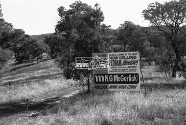
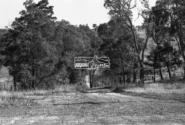
Negative - Photograph, Shire of Eltham, Eltham Meadows Estate, Zig Zag Road subdivision, Jan. 1980
eltham, eltham meadows estate, k.g. mcgorlick pty ltd, mcgorlick real estate, zig zag road subdivision -
 Eltham District Historical Society Inc
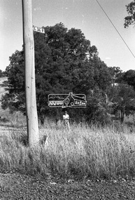
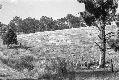
Negative - Photograph, Shire of Eltham, Eltham Meadows Estate, Zig Zag Road subdivision, Jan. 1980
eltham, eltham meadows estate, k.g. mcgorlick pty ltd, mcgorlick real estate, zig zag road subdivision -
 Eltham District Historical Society Inc
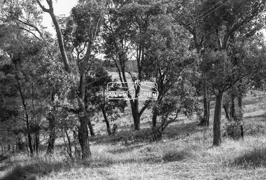
Negative - Photograph, Shire of Eltham, Eltham Meadows Estate, Zig Zag Road subdivision, Jan. 1980
eltham, eltham meadows estate, k.g. mcgorlick pty ltd, mcgorlick real estate, zig zag road subdivision -
 Eltham District Historical Society Inc
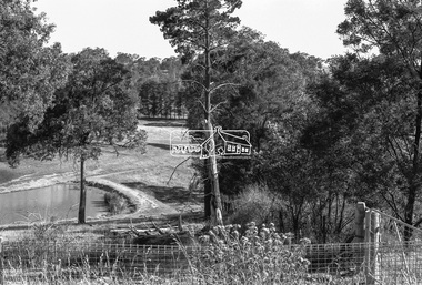
Negative - Photograph, Shire of Eltham, Eltham Meadows Estate, Zig Zag Road subdivision, Jan. 1980
eltham, eltham meadows estate, k.g. mcgorlick pty ltd, mcgorlick real estate, zig zag road subdivision -
 Eltham District Historical Society Inc
Negative - Photograph, Shire of Eltham, Eltham Meadows Estate, Zig Zag Road subdivision, Jan. 1980
eltham, eltham meadows estate, k.g. mcgorlick pty ltd, mcgorlick real estate, zig zag road subdivision -
 Eltham District Historical Society Inc
Negative - Photograph, Shire of Eltham, Eltham Meadows Estate, Zig Zag Road subdivision, Jan. 1980
eltham, eltham meadows estate, k.g. mcgorlick pty ltd, mcgorlick real estate, zig zag road subdivision -
 Eltham District Historical Society Inc
Negative - Photograph, Shire of Eltham, Eltham Meadows Estate, Zig Zag Road subdivision, Jan. 1980
eltham, eltham meadows estate, k.g. mcgorlick pty ltd, mcgorlick real estate, zig zag road subdivision -
 Eltham District Historical Society Inc
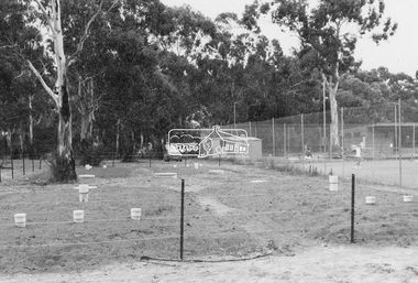
Photograph - Black and White Print, Shire of Eltham, Eltham Tennis Club, Andrew Park, Youth Road, Eltham, Jan. 1980
eltham tennis club, tennis court, youth road -
 Eltham District Historical Society Inc
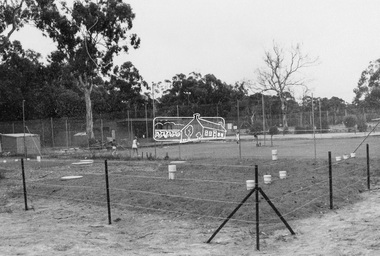
Photograph - Black and White Print, Shire of Eltham, Eltham Tennis Club, Andrew Park, Youth Road, Eltham, Jan. 1980
eltham tennis club, tennis court, youth road -
 Eltham District Historical Society Inc
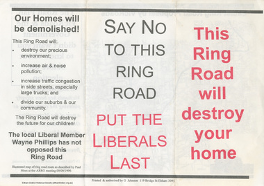
Document - Flyer, Greg Johnson et al, Say No to this Ring Road, 9 Sep 1999
anti ring road organisation (arro), dr paul mees, greg johnson, kennett government, liberal government, melbourne, metropolitan orbital transport corridor, metropolitan ring road, vicroads, victoria, wayne phillips m.p., map -
![Document - Admission Ticket, Briar Hill Hall Trust, Picture Night, Comedy: 'BEDTIME FOR BONGO' with Ronald Regan [sic] and Shorts, ST. Faith's Hall, Cnr Price Avenue & Mountain View Road, Montmorency, Saturday, 13th August at 8pm, 1955](/media/collectors/4f729f7b97f83e03086018a5/items/62d3a368ec2b5dafd05f2739/item-media/62d3a422ec2b5dafd05f2c49/item-fit-380x285.jpg) Eltham District Historical Society Inc
Eltham District Historical Society IncDocument - Admission Ticket, Briar Hill Hall Trust, Picture Night, Comedy: 'BEDTIME FOR BONGO' with Ronald Regan [sic] and Shorts, ST. Faith's Hall, Cnr Price Avenue & Mountain View Road, Montmorency, Saturday, 13th August at 8pm, 1955
Presented by Briar Hill Hall Trust and St Faith's Pre-School Centre, Saturday, 13th August 1955.1955, admission ticket, bedtime for bongo (film), briar hill hall trust, montmorency, mountain view road, picture night, price avenue, ronald regan, st faith's hall, st faiths pre-school centre, ticket, cinema, ronald reagan -
 Eltham District Historical Society Inc
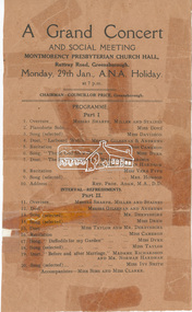
Document - Programme, A Grand Concert and Social Meeting, Montmorency Presbyterian Church Hall, Rattray Road, Greensborough, Monday, 29th Jan., A.N.A. Holiday at 7 p.m, 1951
Held in 1951concert performance, cr. price, madame richardson, miss cameron, miss clarke, miss davidson, miss dove, miss dyke, miss ivy smith, miss sims, miss taylor, miss vera fyfe, montmorency presbyterian church hall, mr andrews, mr derbyshire, mr gilsenan, mr miller, mr norman hardman, mr sharpe, mr staines, mrs howson, program, rattray road, rev. prof. adam -
 Eltham District Historical Society Inc
Photograph - Digital Photograph, Marguerite Marshall, View of the Yarra River from 'Worlingworth', 10-26 Banoon Road, Eltham, 30 January 2006
'Worlingworth', Eltham, home of noted anthropologist the late Professor Donald Thomson and his wife Dorita Thomson. Covered under Heritage Overlay, Nillumbik Planning Scheme. Published: Nillumbik Now and Then / Marguerite Marshall 2008; photographs Alan King with Marguerite Marshall.; p127This collection of almost 130 photos about places and people within the Shire of Nillumbik, an urban and rural municipality in Melbourne's north, contributes to an understanding of the history of the Shire. Published in 2008 immediately prior to the Black Saturday bushfires of February 7, 2009, it documents sites that were impacted, and in some cases destroyed by the fires. It includes photographs taken especially for the publication, creating a unique time capsule representing the Shire in the early 21st century. It remains the most recent comprehenesive publication devoted to the Shire's history connecting local residents to the past. nillumbik now and then (marshall-king) collection, banoon road, donald thomson, dorita thomson, eltham, worlingworth -
 Eltham District Historical Society Inc
Photograph - Digital Photograph, Jim Connor, Lake, Eltham Cemetery, 40 Mount Pleasant Road, Eltham, 9 September 2009
Robert Boyle Landscape Design created the original design and construction of the lake in 1993. They are renowned local landscape designers and have carried out numerous projects at the Cemetery, including the major upgrades to the lakeside design in 2020.jim connor collection, eltham, eltham cemetery, lake, mount pleasant road -
 Eltham District Historical Society Inc
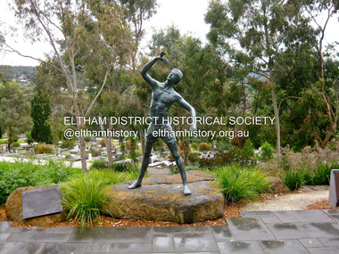
Photograph - Digital Photograph, Jim Connor, Young Man Awakening, Matcham Skipper 2008, Eltham Cemetery, Mount Pleasant Road, Eltham, 13 November 2011
Commissioned by the Eltham Cemetery Trust in 2008 in recognition of the cemetery's 150th anniversary.jim connor collection, 150th anniversary, art in public places, eltham, eltham cemetery, eltham cemetery trust, main road, matcham skipper, sculptures, young man awakening -
 Eltham District Historical Society Inc
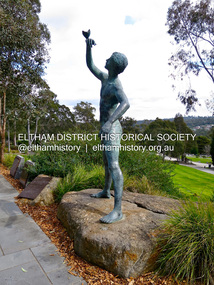
Photograph - Digital Photograph, Jim Connor, Young Man Awakening, Matcham Skipper 2008, Eltham Cemetery, Mount Pleasant Road, Eltham, 24 August 2015
Commissioned by the Eltham Cemetery Trust in 2008 in recognition of the cemetery's 150th anniversary.jim connor collection, 150th anniversary, art in public places, eltham, eltham cemetery, eltham cemetery trust, main road, matcham skipper, sculptures, young man awakening -
 Eltham District Historical Society Inc
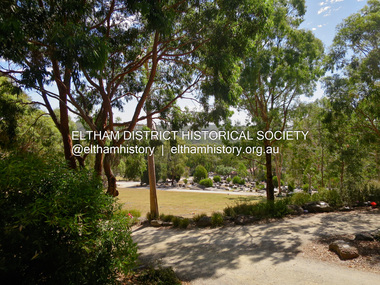
Photograph - Digital Photograph, Jim Connor, Eltham Cemetery, 40 Mount Pleasant Road, Eltham, 3 March 2016
jim connor collection, eltham, eltham cemetery, mount pleasant road -
 Eltham District Historical Society Inc
Photograph, Fay Bridge, Wattletree Road Bridge, Eltham, c.Jan. 1990
Shows Eltham Council sign notifying temporary closure of the bridge 19 Feb to 27 April 1990 for redecking. Illustrates the timber decking of the bridge and pedestrian footbridge extension on southern side.fay bridge collection, 1990-01, wattletree road bridge -
 Eltham District Historical Society Inc
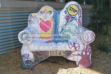
Photograph, Fay Bridge, Seat mosaic outside Purdys Furniture, 31 Sherbourne Road, Briar Hill, October 2011
The seat commemorates the popular local Lollypop manfay bridge collection, 2011-10, briar hill, lollypop man, mosaics, public art, purdy's furniture, sherbourne road -
 Eltham District Historical Society Inc
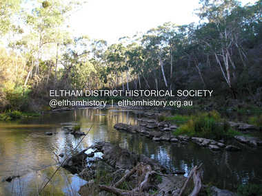
Photograph, Fay Bridge, Yarra River near Laughing Waters Road, Eltham, April 2016
fay bridge collection, 2016-04, laughing waters, yarra river -
 Eltham District Historical Society Inc
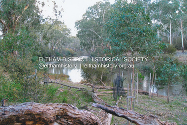
Photograph, Fay Bridge, Yarra River near Laughing Waters Road, Eltham, June 2016
Viewed from the Warrandyte side opposite the Eel trap at Killeaveyfay bridge collection, 2016-06, laughing waters, yarra river -
 Eltham District Historical Society Inc
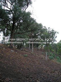
Photograph, Fay Bridge, Longridge, Alexander Road, Warrandyte, 4 May 2019
Situated on the Warrandyte side of the Yarra River opposite Glynn's Dairy Farm, North Warrandyte, the property is in ruins and remains fenced off as of 2023fay bridge collection, glynns, longridge, ruins, warrandyte, 2019-05-04, alexander road -
 Eltham District Historical Society Inc
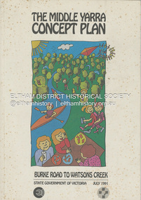
Book, State Government of Victoria, The Middle Yarra Concept Plan: Burke Road to Watsons Creek, July 1991
A draft concept plan developed for the Middle Yarra River between Burke Road and Watsons Creek which includes planning controls, developed and managed to meet the recreation and landscape objectives whilst protecting the natural resourcesa nd cultural heritage. It established a broad framework for more detailed plans and guidelines. Jointly produced by staff from the Victorian Department of Planning and Housing. July 1991.non-fictionA draft concept plan developed for the Middle Yarra River between Burke Road and Watsons Creek which includes planning controls, developed and managed to meet the recreation and landscape objectives whilst protecting the natural resourcesa nd cultural heritage. It established a broad framework for more detailed plans and guidelines. Jointly produced by staff from the Victorian Department of Planning and Housing. July 1991.recreation areas, regional planning, yarra river, watsons creek -
 Eltham District Historical Society Inc
Album - Photograph Album, J.A. McDonald, Bridge and Road Reconstruction Works, Shire of Eltham, 1952-1962
J.A. McDonald produced this record in the course of his responsibilities as Shire Engineer for Eltham Shire Council.Record of various Shire of Eltham infrastructure works undertaken during the period of 1952-1962 involving bridge and road reconstruction projects, sometimes with Eltham Shire Council Project Reference numbers quoted. It was during this period that a number of significant improvements were made to roads and new bridges constructed within the shire that remain in place as of present day (2022). In many situations, the photos provide a tangible visible record of infrastructure that existed throughout the early days of the Shire. The album was put together by or under the direction of the Shire Engineer, J.A. McDonald.a. gillies, alistair knox park, benchmark studies, bend of islands, blease road, box hill state school, box hill teachers college, box hill tip, bridge construction, bridge street bridge, bridge, brisbane street, brougham steet, bulldozer, cecil street, charis pelling, cherry tree road, city of preston, cr. a. brinkkotter, cr. charis pelling, cranes, cromwell street, diamond creek (creek), diamond street, dixons creek bridge, dixon's creek road, drott, eltham leisure centre, eltham north, eltham police station, eltham, eltham-yarra glen road, f. wood, fitzsimons lane bridge, flat rock road, flood damage, floods, floodwater, footpaths and gutters, ford service garage, g. blair, garden hill, glen park bridge, glenauburn road, grand hotel, haldane road, healesville, healesville-yarra glen road, heidelberg-kinglake road, henley road bridge, henley road, hill property, hurstbridge water scheme, hurstbridge, hurstbridge-arthurs creek road, infrastructure, j. jolly, kangaroo ground, kangaroo ground-queenstown road, kangaroo ground-st andrews road, lilydale shire office, long gully bridge, long gully creek, long gully road, long gully, lower plenty bridge, lower plenty footbridge, lower plenty oval, lower plenty road, lower plenty, main road, methodist church, montmorency, mount pleasant road, new holland, old healesville road, opening ceremony, oxley bridge, para road, paul creek bridge, paul creek road, paul krafeznk, pinnacle lane, plaques, plenty river trail, plenty river, presbyterian church, prof donald thomson, pryor street, railway crossing, railway parade, rattray road, reconstruction works, reichelt avenue, research (vic.), research oval, road construction, rymers corner, shire of eltham, shire of whittlesea, silvan road bridge, silver street bridge, silver street, sir dallas brooks, smedley property, st andrews, steels creek, susan street, tarrawarra, tony carberry, uniting church, upper yarra dam, upper yarra reservoir, w.e. wolf, waterfall property, watsons creek, wattletree road bridge, wattletree road, wattletree road bridge, worlingworth, yarra glen, york street, yow yow creek -
 Eltham District Historical Society Inc
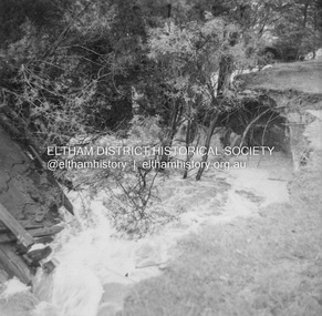
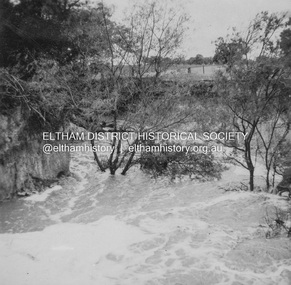
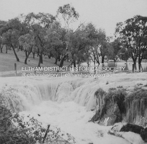
Album - Photograph, J.A. McDonald, Dixons Creek Road, 23 Sep. 1955
Dixons Creek in floodRecord of various Shire of Eltham infrastructure works undertaken during the period of 1952-1962 involving bridge and road reconstruction projects, sometimes with Eltham Shire Council Project Reference numbers quoted. It was during this period that a number of significant improvements were made to roads and new bridges constructed within the shire that remain in place as of present day (2022). In many situations, the photos provide a tangible visible record of infrastructure that existed throughout the early days of the Shire. The album was put together by or under the direction of the Shire Engineer, J.A. McDonald.1955-09-23, bridge construction, dixons creek bridge, dixon's creek road, flood damage, floods, infrastructure, road construction, shire of eltham -
 Eltham District Historical Society Inc
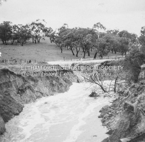
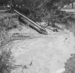
Album - Photograph, J.A. McDonald, Dixons Creek Road, 23 Sep. 1955
Dixons Creek in flood Temporary bridge washed outRecord of various Shire of Eltham infrastructure works undertaken during the period of 1952-1962 involving bridge and road reconstruction projects, sometimes with Eltham Shire Council Project Reference numbers quoted. It was during this period that a number of significant improvements were made to roads and new bridges constructed within the shire that remain in place as of present day (2022). In many situations, the photos provide a tangible visible record of infrastructure that existed throughout the early days of the Shire. The album was put together by or under the direction of the Shire Engineer, J.A. McDonald.1955-09-23, bridge construction, dixons creek bridge, dixon's creek road, flood damage, floods, infrastructure, road construction, shire of eltham -
 Eltham District Historical Society Inc
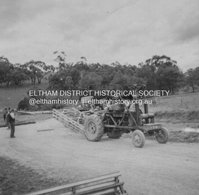
Album - Photograph, J.A. McDonald, Dixons Creek Road, Oct. 1955
October 1955 Bringing up Bailey panelsRecord of various Shire of Eltham infrastructure works undertaken during the period of 1952-1962 involving bridge and road reconstruction projects, sometimes with Eltham Shire Council Project Reference numbers quoted. It was during this period that a number of significant improvements were made to roads and new bridges constructed within the shire that remain in place as of present day (2022). In many situations, the photos provide a tangible visible record of infrastructure that existed throughout the early days of the Shire. The album was put together by or under the direction of the Shire Engineer, J.A. McDonald.infrastructure, road construction, shire of eltham, 1955-10, bailey bridge, bridge construction, dixons creek bridge, dixon's creek road