Showing 10961 items matching " plan"
-
 Ringwood and District Historical Society
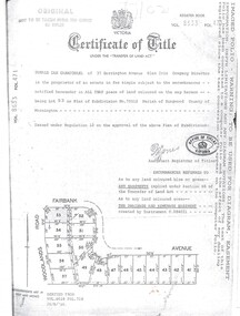
Document, Certificate of Title Vol 8633 Fol 471, Plan of Subdivision No. 73512, Parish of Ringwood, County of Mornington
A4 Title Search Enquiry printout dated 2003, with Subdivision Map including Fairbank Avenue and Woodlands Road, Heathmont, Vic.Issued under Regulation 12 on the approval of the above Plan of Subdivision. Derived from Vol 8618 Fol 718, 26/8/1966. Proprietor - Donald Ian Carmichael of 37 Dorrington Avenue Glen Iris. -
 Ballarat Tramway Museum
Document - Photocopy, City of Ballaarat, Plan of Gardens, 1920s?
Photocopy - No Number, no date, other than BTM Number 228, No title – plan showing roads and trees in the Gardens area, early drawings, many roads on the east side of Lake Wendouree not built . Photocopy onto heat sensitive paper – 9 separate sheets joined with tape. An additional sheet added at the St. Aidans end showing roads – in pencil. Probably compiled for the BTPS by Bill Kingsley for planning purposes.Has “228” in biro on rear of sheet, and “Scale 100 foot to 1 inch” on front of sheet.trams, tramways, signals, forest city signals, equipment, electrical engineering -
 Melbourne Tram Museum
Newspaper, The Age, “Three-step plan for safe public transport”, 1/05/2020 12:00:00 AM
Newspaper clippings titled: “Three-step plan for safe public transport” by Timna Jacks Newspaper clipping from the Age 1/05/2020 Covers planned restrictions for safe public transport use due to Covid-19. Suggesting public transport should run half empty with no standing room to enable commuters to observe a safe distance. Capacity on trams could suffer leaving services at 13% capacity.trams, tramways, public transport, melbourne, safety, covid-19 -
 Greensborough Historical Society
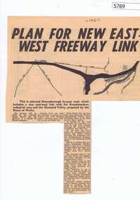
Newspaper Clipping, Diamond Valley News, Plan for new East-West freeway link, 1967c
Early plans for the Greensborough by-pass and western ring road.Newspaper clipping, black and white text and image.greensborough bypass, western ring road -
 Federation University Historical Collection
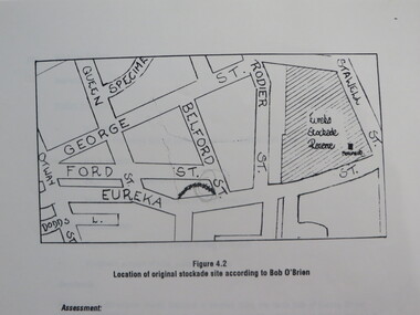
Report, Concept Study for the Further Development of the Eureka Stockade Reserve Conservation Plan, Vol 3, c1992
The objectives of the study were to * gather historical data and confirm the cultural significance of the site and reserve. * review existing site conditions including ownership together with current and proposed land uses. * Eureka Stockade location Copy of a 38 page report called "Concept Study for the Further Development of the Eureka Stockade Reserve Conservation Plan Vol 3", published by Ballarat University College. Authors are not stated. eureka, eureka stockade, ballarat university college, bert strange, bob o'brien, weston bate, alec barnett, jack chisholm, lloyd jenkins, eureka stockade location, cultural significance, eureka stockade site -
 Victorian Aboriginal Corporation for Languages
Book, Ministerial Council on Education Employment Training and Youth Affairs, National statement for languages education in Australian schools : national plan for languages education in Australian schools 2005-2008, 2005
Part 1 National Statement for Languages Education in Australian Schools - purpose and nature of languages education, Part 2, National Plan for Languages Education in Australian Schools 2005-2008.languages in education, curriculum development, language education frameworks, language policy -
Lakes Entrance Historical Society
Book, Landsmith Pty Ltd, North Arm Action Plan, 1996
This plan was formulated as a comprehensive guide for sustainable management of the waters and environment of the North Arm while providing recreational opportunities that are in balance with the environmental values of the North Arm and its catchment Lakenvironment, vegetation, recreation -
Lakes Entrance Historical Society
Book, East Gippsland Community Wellbeing Reference Group, East Gippsland Shire Community Well-Being Plan 2005, 2005c
Plan provides a new framework for legally required municipal public health in which community wellbeing can be considered within council and more broadly in the community East Gippsland Victoriahealth services, education, houses -
 Federation University Historical Collection
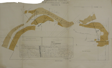
Plan, Underground Workings New Australasian Company Creswick, not dated
A plan of the underground working of the New Australasian Mine at Creswick, showing Wheeler's Bridge Road, a transverse section on the West Main Reef Drive and Line AB. It als shows the locations of the Red streak or Australasian Gutter, Reef wash, Eastern Wash, Australasian and Eaglehawk Shaft and prospecting drives.mining, plans, cgt, creswick, new australasian company, wheeler's bridge, red streak gutter, australasian gutter, reef wash, eastern wash, australiasian shaft, eaglehawk shaft -
 Greensborough Historical Society
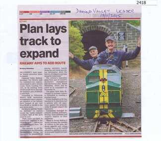
Newspaper Clipping, Plan lays track to expand, 18/11/2015
Outlines plans to expand the Diamond Valley Miniature Railway in Eltham.News clipping, black text, colour image.diamond valley miniature railway -
Federation University Historical Collection
Book, Jacob Lamaro et al, Daylesford Environmental and Physical Plan Sub Report, c2007, c2007
This report was done by University of Ballarat 'Tourism Planning and Development' students.White soft covered book of 33 pages. daylesford, mineral water, hepburn, flora, fauna, wombat state forest, lake daylesford, geology, hepburn reserve, tourism -
Federation University Historical Collection
Book, Tanya Wisneske et al, Daylesford Marketing Plan, c2006, c2006
This report was done by University of Ballarat 'Tourism Planning and Development' students.Soft covered book of 29 pages. daylesford, hepburn, tourism, marketing plan -
 Peterborough History Group
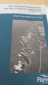
Book, Port Campbell National Park and Bay of Islands Coastal Park Draft Management Plan September 1997, 1997
Information re planning for Park released for public comment in 1997.Contributes information on the history and development of the Bay of Islands Coastal ParkGovernment published 81 page + maps book.peterborough 3270, bay of islands coastal park, parks victoria - peterborough, bay of islands -
 Greensborough Historical Society
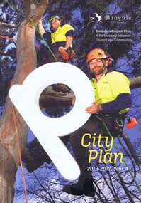
Book, Banyule City Council, City plan 2013-2017, Year 4, 2013-2017
A review of the Banyule Council's Plan - a partnership between Council and Community.Soft cover, 132 p., col. illus.banyule city council, community, banyule council, town planning -
 Federation University Historical Collection
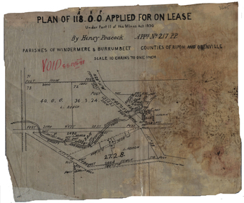
Plan, Henry Peacock's Lease, 1898, 1898
Plan on linen of Henry Peacoack's application for a lease. Scale: 10 chains to 1 inch (1:7920)henry peacock, mining lease, l. roach, windermere, burrumbeet -
 Federation University Historical Collection
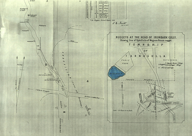
Plan, A.M. Howitt, Nuggets at the Head of Ironbark Gully, Tarnagulla, c1907
Plan showing part of the township of Tarnagulla, and the Ironbark Gully area including Western Reef and Creek's Hill.tarnagulla, ironbark gully, western reef, creek's hill, cgt -
 Kew Historical Society Inc
Plan - Subdivision Plan, Windella-Darnley Subdivision, Studley Park, 1920s
Subdivision plans are historically important documents used as evidence of the growth of suburbs in Australia. They frequently provide information about when the land was sold on which a built structure was subsequently constructed as well as evidence relating to surveyors and real estate and financial agents. The numerous subdivision plans in the Kew Historical Society's collection represent working documents, ranging from the initial sketches made in planning a subdivision to printed plans on which auctioneers or agents listed the prices for which individual lots were sold. In a number of cases, the reverse of a subdivision plan in the collection includes a photograph of a house that was also for sale by the agent. These photographs provide significant heritage information relating house design and decoration, fencing and household gardens.Version 1 of two subdivision plans (the later one is MAP.0027) for the section of Studley Park Road near the Junction on the south side. Named in the subdivision are the mansions of Darley and Windella (now demolished). Before the subdivision of Darley and Windella, both houses fronted Studley Park Road. Both houses appear to be advertised as lots in the subdivision. Bisecting the subdivision is a street, Antrim Avenue that was never constructed. A street, which was subsequently constructed in this vicinity, was Merrion Place, which now runs between Studley Park Road and Highfield Grove. There are 14 proposed lots in this subdivision."Antrim Avenue. See over for new plan"subdivision plans - kew, studley park, windella, darnley, studley park road -- kew (vic.), merrion place -- kew (vic.), merrion grove -- kew (vic.), highbury grove -- kew (vic.) -
 Port Melbourne Historical & Preservation Society
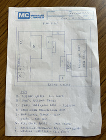
Document, MM Crane Factory - Plan View, 18 Feb 2020
Blue printed plan view of Malcolm Moore Crane Factory with lettered index of areas within the factory from 1979 some with names listed including Norm (presumably Norm Robinson).built environment - industrial, industry, engineering, malcolm moore pty ltd, norm robinson -
 Whitehorse Historical Society Inc.
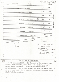
Document, Plan of Subdivision, 1861
Copy of plan of subdivision by Patrick RileyCopy of plan of subdivision by Patrick Riley of Section 77, Parish of Nunawading 'Springfield Township' 1861. Bounded by Whitehorse Road, Walker's Road, (now known as Springvale Road) and Springfield RoadCopy of plan of subdivision by Patrick Rileyland sales, riley, patrick, whitehorse road, nunawading, walkers road, springfield road, black street, robertson street, sandy street, burnt street, luckie street, bridge street, creek street, koonung street, thompson street -
 Greensborough Historical Society
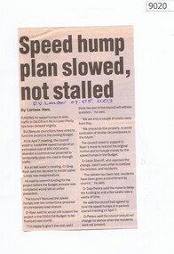
Newspaper - Newspaper Clipping, Speed hump plan slowed, not stalled, 07/05/2003
Speed hump plan for Old Eltham Road Lower Plenty 2003Newspaper clipping, text only.old eltham road lower plenty, speed humps, banyule -
Federation University Historical Collection
Book, Visitor Servicing Plan 2006 - Daylesford Region, 2006
Visitor Servicing Plan 2006 - Daylesford Region. Prepared by the University of Ballarat.White bound book of 26 pages.daylesford, university of ballarat, christine watts, rheanne hogema, kathy thomas, michael stevenson, mary hollick, overview of daylesford and accommodation services, professionalism of local industry, assessment of of information provision and its distribution internal to the destination, conclusions and recommendations, references, implementing visitor servicing plan, hepburn shire, tourism victoria, tourism -
Federation University Historical Collection
Book, Toni Woolley et al, Port Fairy Community and Organisational Plan, 1999
Port Fairy Community and Organisational Plan. University of Ballarat Students' Project.White bound book of 35 pages plus 6 appendices.port fairy, toni woolley, tamara lang, janelle gilbert, ben balshaw, grant caromody, executive summary, introduction, background to port fairy, methodology, limitations, appraisal of tourism planning and development to date, assessment of local community issues, attitudes and involvement in tourism, roles of local and regional tourism associations, effectiveness of local & regional tourism associations, analysis of services and service quality, moyne shire council, friends of port fairy, tourism victoria, country victoria tourism, great ocean road marketing, shipwreck coast tourism, port fairy tourism association inc, moyne shire, department of natural resources and environment, the western coastal board, tourism accreditation board of victoria, george borg, craig delahoy, michael hearn, jodie honan, judith kershaw, andrea lowenthal, neil martin, john ploenges, james purcell, peter strickland, mark thompson, libby wilson, michael pearlman, battle of the moyne, tourism planning, great ocean road -
Creswick Campus Historical Collection - University of Melbourne
Document, Management Plan for Mt.Beckworth Forest Reserve, c.1966
Hand typed loose covers Management Plan for Mt.Beckworth Forest ReserveDocument -
Creswick Campus Historical Collection - University of Melbourne
Book, Forests Commission of Victoria, Woohlpooer Management Plan, 1936
This is a typed document of a Woohlpooer Working Plan for management of reserved forests 1936Document -
 Stawell Historical Society Inc
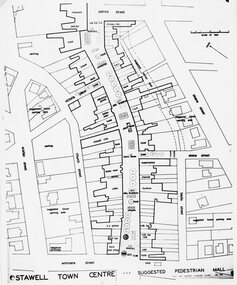
Photograph, Stawell Pedestrian Mall -- Proposed Plan and Concept drawing 1970
Stawell Pedestrian Mall. Proposed Plan and Concept drawing. Feb. 1970stawell -
 Federation University Historical Collection
Plan, Haddon, County of Grenville, 1932, 13/04/1932
The Haddon Parish Plan shows crown parcels government roads, Crown Reserves, Railway. Scale 40 chains to 1" (1:31, 680) WGS 84 Centroid Lat: 37 degrees 34' 00" S Long: 148 degrees 40' 20" E N.S. 9.3km E.W.: 16.1kmhaddon, grenville, cardigan, water supply reserve, nentingbook pre-emptive right, a. mclachlan, lake burrumbeet, e.a. wynne, p. russell, b. hepburn, benjamin hepburn, nentingbool, t.c. wilson, j. amoy, william collard smith, james roach, j. mitchell -
 NMIT (Northern Melbourne Institute of TAFE)
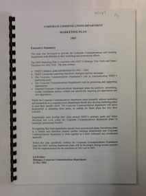
Document, Marketing Plan: Corporate Communications Department 2002, 2002
This document outlines the Marketing Plan for NMIT in 2002, as proposed by the Corporate Communications Department.This document details plans for the marketing and promotion of NMIT.34 pages (approx.), printed on one side of paper. Spiral bound with clear plastic cover.corporate communications, marketing plan, nmit, -
Friends of Ballarat Botanical Gardens History Group
Work on paper - Robert Clark Horticultural Centre, Outline Operation Plan 1995, post 1994-1995. [Very likely 1996]
This Outline Operation Plan was an Initial Discussion Draft (not for Broad Circulation) 1994-1995.This Outline Operation Plan shows how activities and the development of the Robert Clark Centre evolved.19 pages. 1st 3 pages are pale green. Title page has the black and green logo entitled "The Conservatory".1st page has 'Thurs. 10 Aug. 700-730pm written in biro on the top lefthand corner. Back page, top righthand corner has 43 written in biro.robert clark centre, the conservatory, robert clark horticultural centre, operation plan, ballarat botanical gardens, friends of ballarat botanical gardens, john garner, doctor, john garner collection, gardens, ballarat -
Ringwood and District Historical Society
Brochure, Farros Falcon Press, Heathmont Station Estate Pamphlet incl sub division plan (undated0, Not Known
Promotional brochure from estate agents H. C. Costello & Co Auctioneers for the Heathmont Station Estate: 140 beautiful home sites.Large buff coloured bifold pamphlet advertising Heathmont Station Estate. Red and black printing; photo on front and back; subdivision plan inside. +Additional Keywords: Costello, H. C. & Co. -
NMIT (Northern Melbourne Institute of TAFE)
Booklet: NMIT Strategic directions and Strategic plan 1996
A4 size bound booklets. Years held: Strategic directions 1995-1997; 1996-98; Strategic plan 2004-2008; 2009 the Northern journey; 2007-2010; Library 2010-2012reports, nmit