Showing 10390 items
matching plans
-
 Greensborough Historical Society
Map, Greensborough Map with Rail Line Plan, 1970s
Central Greensborough area, including railway line and some landowners. Basic map made c. 1902; annotations dated to circa 1970sTwo copies of planParish of Keelbundora, County of Bourke. Central Greensborough areagreensborough, greensborough railway station -
 Ringwood and District Historical Society
Envelope, Packet: Planning - Ringwood and Croydon Clippings and Newspaper 1978-1983, 1978-1983
Planning - Ringwood and Croydon -
 Federation University Historical Collection
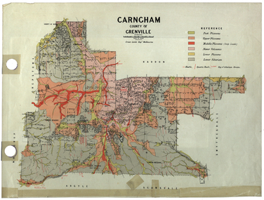
Plan, Carngham, County of Grenville
A plan of Carngham, Victoria.snake valley, timber reserve, poverty point, recreation reserve, carngham, county of ripon, county of grenville, plan -
 Federation University Historical Collection
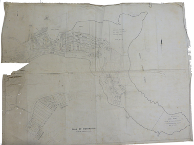
Plan, Plan of Merimbula, 1932, 1932
Printed plan on cottonmerimbula, south pacific ocean -
 Federation University Historical Collection
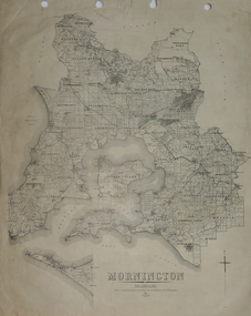
Plan, Mornington, 1926, 1926
Printed plan on papermornington, phillip island, western port bay, bass straight, wonthaggi, lang lang, sherwood, nepean, narre worran, ringwood -
 Federation University Historical Collection
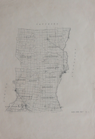
Plan, Kara Kara
Printed plan on paperkara kara, tatchera, gladstone -
 Federation University Historical Collection
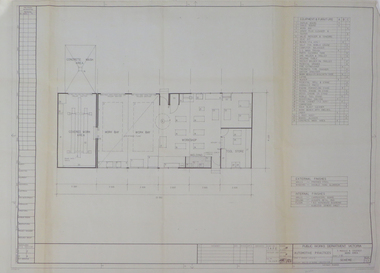
Plan, Ballarat School of Mines Practices Plan, 1981, 1981
Large building plan.ballarat school of mines, john t. green, automotive practices, trades, buildings, architectural plans -
 Federation University Historical Collection
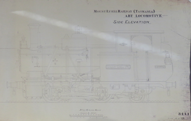
Plan, Mount Lyell Railway (Tasmania) ABT Locomotive Side Elevation, undated
On 29 March 1893 the Mount Lyell Mining and Railway Company was formed. This Tasmanian mining company was often referred to as Mount Lyell. Mount Lyell, and was the dominant copper mining company of the Tasmanian West Coast from 1893 to 1994, and was based in Queenstown, Tasmania. After consolidation of leases and company assets at the beginning of the twentieth century, Mount Lyell was the major company for the communities of Queenstown, Strahan and Gormanston. It closed in 1994. The Mount Lyell mining operations produced more than a million tonnes of copper, 750 tonnes of silver and 45 tonnes of gold since mining commenced in the early 1890s – which is equivalent to over 4 billion dollars worth of metal in 1995 terms.Copy of a plan of a locomotive.mount lyell, locomotive, mount lyell railway, quuenstown, tasmania, strahan, gormamston, railway -
 Federation University Historical Collection
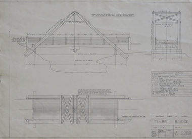
Plan, Plan for a Timber Bridge
Plan for a timber bridgetimber bridge, j. calisto, geoff biddington -
 Federation University Historical Collection
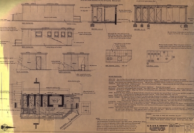
Plan, Ballarat School of Mines Trade Toilet Block Alterations and Renovations, 1976, 04/08/1976
Computer generated planballarat school of mines, toilet block -
University of Melbourne, Burnley Campus Archives
Booklet - Brochure, Botanic Gardens Queen Victoria Gardenss Alexandra Park, 1924
Brochure and plan of gardensgardens -
Creswick Campus Historical Collection - University of Melbourne
Document, 1933
Creswick Working Plan -
Stawell Historical Society Inc
Map - Plan, Earle and Partners, Restoration of Pleasant Creek Courthouse Stawell West 1975, 4/8/1975
Designs for Restoration. Includes details for Public Toilet & Trees.A1 Plan of PrecinctDrawing No. 5 4.8.1975. Pleasant Creek Court of Petty Sessions Built in 1860. Museumstawell historical -
Whitehorse Historical Society Inc.
Map, Sample Plan
Sample Plan of Shireroad construction and maintenance -
 Unions Ballarat
Plan - Photograph: Trades Hall building architects' design, 1886
Original architects' drawings for the construction of Trades Hall, Ballarat. November 5th 1886 the building committee called for tenders for the erection of a Trades Hall on the following conditions. The amount to be expended to be no more than £3,000; bluestone foundations; the front of the building to be of Grampians freestone and walls of brick. Building to be 3 storeys high, containing 14 rooms with a hall capable of seating 600 persons, roof to be of slate and workmanship and material to be of the best quality. The design submitted by Messrs James and Piper was accepted subject to amendment.Relevance to the history of Trades Hall, Ballarat.Paper - architects' plans.btlc, ballarat regional trades and labour council, ballarat trades and labour council, ballarat trades hall, eight hours anniversary committee, james and piper, architects' drawings, building -
University of Melbourne, Burnley Campus Archives
Plan, Proposed Site for Plant Science Laboratory and Glasshouse Block, 1964
Plan on tracing paper.laboratory, glasshouse -
University of Melbourne, Burnley Campus Archives
Plan, Proposed BIH Enclosure Rear S.A.B. V.C.A.H. Burnley, c. 1980
Plan on tracing papervcah, burnley -
 Friends of Ballarat Botanical Gardens History Group
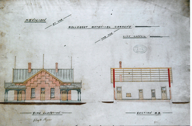
Photograph - Digital image - jpg, Gardens Pavilion design, Ballaarat
colour photograph of planpavilion plan, ballaarat botanical gardens, circa 1890 -
 Friends of Ballarat Botanical Gardens History Group
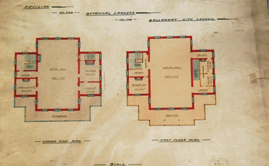
Photograph - Digital image - jpg, Gardens pavilion floor plan, Ballaarat
Colour photograph of a planplan, gardens pavilion, ballaarat circa 1890 -
 Melton City Libraries
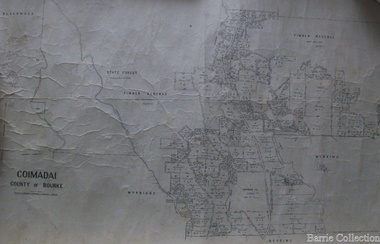
Map, Coimadai County of Bourke, 1911
Town Plan of Meltoncouncil -
University of Melbourne, Burnley Campus Archives
Plan, 36 Railway Ave, Armadale, 1991-1997
Sets of plans for a Residential Garden produced by students for an assignment. (1) Tracing paper and paper copies site plan sketch. (2) Janine Bugg - Assessment Preliminary Plan, Concept Plan, Site Inventory and Analysis, Site Elevation A, Section Elevation B dated 26.05.1994. (3) Carmen Skrobonja - Assessment Main Plan & Section Elevation, Concept Plan dated 31.05.1991. (4) G. Mutimer - Preliminary Plan, Section Elevation, May 1994. (5) Melissa King - Assessment, Site Inventory & Analysis, Site Concept Plan, Preliminary Main Plan, Section Elevation, May 1997. (6) Jim Despotellis - Site Inventory & Analysis, Concept Plan, Preliminary landscape Design, 25.04.1994 - 15.05.1995. (Also see B11.0775.) (7) 33 Railway Ave (sic), Colour photographs pasted on paper. (8) Marli Draper - Site Inventory and Analysis, Concept Plan, Preliminary Plan, Perspective Feature Bed. (Also see B11.0773). (9) Cowan (Creations) - Site Inventory and Analysis, Concept Plan, Preliminary Plan, Assessment, 30.05.1994. (10) McRae (Designs) - Site Inventory and Analysis, Preliminary Main Plan, Concept Plan, Section View to Tussock Grass and Eucalyptus, 30.05.1997 - 01.06.1997. (11) Leah Syme - Site Inventory and Analysis.armadale, janine bugg, carmen skrobonja, melissa king, jim despotellis, marli draper, leah syme, g. mutimer, students, assignments -
Federation University Historical Collection
Booklet, Ballarat School of Mines Report to Council on Possible Future Building Developments, 1965, 1965
A foolscap plan with a number of plans relating to possible future building developments at the Ballarat School of Mines. Includes proposed plan for the former M.B. John Site (neaar brew tower)ballarat school of mines, buildings, building developments, e.j. barker, library, engineering and applied science, gaol residences, trades, ballarat junior technical school, materials testing laboratory, martin report, hickman street -
Port Melbourne Historical & Preservation Society
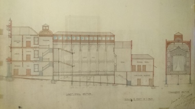
Plan - Auditorium, Port Melbourne Town Hall, A A Millar, Clerk of works, 1915
Plan for "New Auditorium for Town Council Port Melbourne". Floor plan; cross section C/D, cross section A/B; floor plan balcony ground floor; 1915"New Auditorium for Town Council Port Melbourne":Heath, A.V. Town Clerk and Surveyor:A.A. Millar Spray Street, Elwood. Phone BX 1762, Clerk of Work 1915port melbourne town hall, arthur victor heath, town clerks, a a millar, g t reeves -
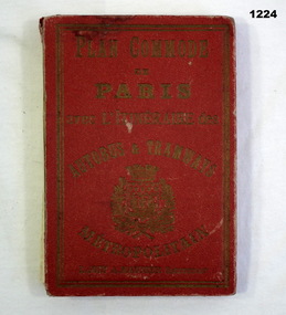 Bendigo Military Museum
Plan - MAP, TOURIST, L Joly, A Maunier, WWI
The map belonged to Jack Grinton No 1043 38th Batt AIF. At Wars end extensive leave was granted, Jack journeyed to Paris, Nice, Monte Carlo taking many photos. Part of the Grinton collection which included hundreds of negatives and developed photos that he took during the War. Refer Cat No 1280 for service details. Refer 1317P, 1320P.Map of Paris. Red cardboard or paper hardcover, new edition guide of metropolitan Paris (ministries, tramways, monuments), Index in front, folded paper map attached to back cover. "Plan commode de Paris avec l'itineraire des autobus & tramways metropolitan"documents-maps, french -
 Victorian Aboriginal Corporation for Languages
Book, Private lives, public records : family history resources at Public Record Office Victoria, 2003
Intended as a key resource for both first-time and experienced genealogists. It offers an introduction to the role, services and collection of Public Record Office Victoria, and a guide for family history researchers using the archives.colour photographs, b&w photographs, charts, letters, records, maps, plansgenealogy, local history, family history, public records, bibliographies, catalogues, victorian history -
 Robin Boyd Foundation
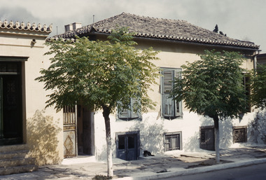
Slide, Robin Boyd, 1950
Penleigh Boyd, Robin and Patricia Boyd's son, writes “Prior to 1950 Robin, like most other amateur or hobby photographers, took black and white printed photographs. The oldest slides date from 1950 when Robin and Patricia travelled to Europe on Robin’s Robert Haddon Travelling Scholarship.” In 1948 Robin Boyd was awarded ‘joint first place’ in the Robert Haddon competition for his design of Mildura art gallery. The scholarship helped fund their first overseas trip. Robin and Patricia were passengers on the Greek ship “Cyrenia” departing in May 1950, passing through the Suez Canal and landing in Genoa five weeks later. For six months, they travelled extensively throughout Europe (predominantly driving themselves) - France, Italy, United Kingdom, Sweden, Denmark, Germany, Austria, Switzerland and Spain.Colour slide in a mount. Two-storey house in Piraeus, GreeceGreece / House / House in Pyraeus, 2-Storey Living Plan (All Handwritten)haddon travelling scholarship, haddon, robin boyd, slide -
Clunes Museum
Document, VICTORIAN GOVERNMENT DEPT. OF PLANNING, THE RURAL LAND MAPPING PROJECT 1981 - DRAFT, JULY 1981
A REPORT TO THE SHIRE OF TALBOT AND CLUES TO ACCOMPANY AND EXPLAIN THE SET OF PHYSICAL CONSTRAINTS MAPS PRODUCED FOR THE SHIRE AS PART OF THE RURAL LAND MAPPING PROJECT...SOFT COVER, TAN COLOURED DRAFT OF THE RURAL MAPPING PROJECT 1981 - SHIRE OF TALBOT AND CLUNES.non-fictionA REPORT TO THE SHIRE OF TALBOT AND CLUES TO ACCOMPANY AND EXPLAIN THE SET OF PHYSICAL CONSTRAINTS MAPS PRODUCED FOR THE SHIRE AS PART OF THE RURAL LAND MAPPING PROJECT...local history, government, state government, essential services -
 University of Melbourne, Burnley Campus Archives
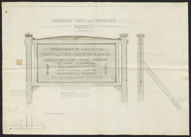
Plan, Proposed Sign for Entrance to Burnley, 1931
(1) Correspondence between Mr Zevan (Government Cool Stores), the Agricultural Superintendent, R. Crowe (Exports Superintendent) and A.W. Jessep re design for new entrance gates at Burnley Gardens, between 31.03.1931 and 09.07.1931. Invoice from signwriter. (2) Pencil sketch of proposed design with anotations. (3) Coloured drawing to scale.On verso of drawing: "Gate sign & Watering plans" and "File State Public Works"mr zevan, cool stores, r. crowe, exports, a.w. jessep, burnley gardens -
University of Melbourne, Burnley Campus Archives
Plan, Yarra Boulevard, Burnley, c.1987
Miscellaneous collection of concept plans and printed plans relating to areas around Yarra Boulevard, Burnley. (1) 3 coloured concept plans on tracing paper. (2) 4 plans from the City of Richmond City Engineers Department Series Yarra 500/042.yarra boulevard, burnley -
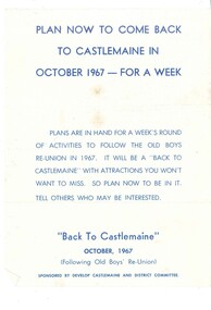 Old Castlemaine Schoolboys Association Inc.
Poster, Plan now to come back to Castlemaine in 1967
Plan now to come back to Castlemaine in October 1967 - for a week plans are in hand for a week's round of activities to follow the old boys reunion in 1967. It will be a back to Castlemaine with attractions you won't want to miss. So plan now to be in it. Tell others who may be interested. Sponsored by developed Castlemaine and district committee