Showing 1125 items matching " waterways"
-
 Lakes Entrance Historical Society
Photograph - Lake Tyers, 1925c
... Waterways ...Also a black and white photograph of tourist launch on Lake Tyers number 03824.1 size 10 x 15 cm photograph dark with damage crease showingBlack and white photograph of two tourist launches and three rowing boats at the landing at Lake Tyers Victoriaboats and boating, forest, waterways -
 Lakes Entrance Historical Society
Photograph - Lake Tyers, 1970c
... Waterways ...Colour photograph showing tourist launch at jetty tall trees in foreground Fishermans Landing Lake Tyers Victoriaboats and boating, forest, waterways -
 Lakes Entrance Historical Society
Postcard - Albert Park Lake Tyers, 1910c
... Waterways ...Note on back to Miss Barber from Betty saying she asked Mrs Blay about accommodation etc. Also another postcard 03833.2 to a Clarence Pawsey dated 18.3.1918Sepia toned postcard showing Albert Park Guest House consisting of bedroom wing on left and detached kitchen dining wing on right, verandah across front of building with two deck chairs and bench on verandah, man and lady standing and lady sitting on bench. Extensive paths and garden in front, glimpses of other buildings at back. Two water tanks at left one round galvanized and one square, trees behind building. Lake Tyers VictoriaAlbert Park Lake Tyers Victoriawaterways, topography, guesthouses -
 Lakes Entrance Historical Society
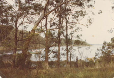
Photograph - Lake Tyers, M Holding, 1/06/1998 12:00:00 AM
... Waterways ...Second colour photograph similar view number 03836.1 size 10x15 cmColour photograph taken after Lake Tyers has broken through the dunes to the sea showing surf breaking on the entrance Lake Tyers Victoria tourism, waterways, beaches -
 Lakes Entrance Historical Society
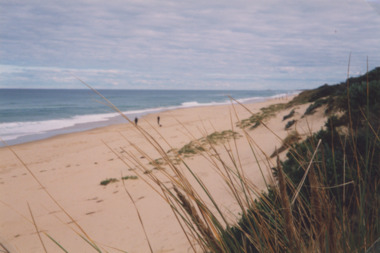
Photograph - Red Bluff, 1992
... Waterways ...Colour photograph taken from the base at the Red Bluff looking to the south east shows low shrubbery on higher elevation above sandy beach, surf breaking with ocean beyond Lake Tyers Victoriaocean, waterways, sand dunes -
 Lakes Entrance Historical Society
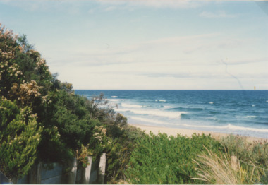
Photograph - Ocean Beach, Lakes Post Newspaper, 1/06/2000 12:00:00 AM
... Waterways ...Colour photograph taken from Eastern Beach looking towards the west showing expanse of sand between calm ocean and shrub covered coastal dunes, two people on sand Lakes Entrance Victoriacoast, ocean, waterways -
 Lakes Entrance Historical Society
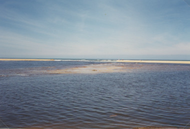
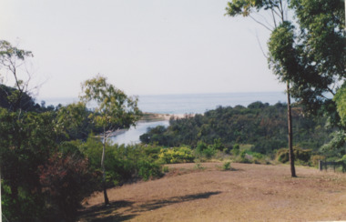
Photograph, Lake Bunga Victoria
... Waterways ...taken from 'Bunga Haven' looking toward the closed entrance with ocean in the background Colour Photograph of Lake Bunga Victoria. Second photo of Lake Bunga waterways, topography, gippsland lakes -
 Lakes Entrance Historical Society
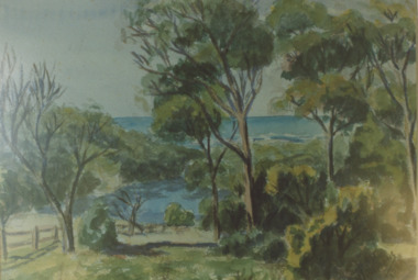
Photograph - Lake Bunga, 1980c
... Waterways ...Colour photograph of a painting by Rodney Symmonds showing lake between overhanging trees with ocean beyond, Lake Bunga Victoriatopography, waterways, forest -
 Lakes Entrance Historical Society
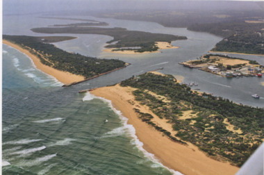
Photograph - Lakes Entrance, Gippsland Ports, 2006 c
... Waterways ...Second copyColour aerial photograph of entrance from Bass Strait to Gippsland Lakes including Bullock Island Reeves Channel Rigby Island houses on Kalimna Hill and Princes Highway winding down Jemmys Point hill into township of Lakes Entrance Victoriaaerial photograph, ocean, waterways -
 Lakes Entrance Historical Society
Photograph - Lakes Entrance, Gippsland Ports, 2006 c
... Waterways ...Also another copy of same photograph number 03864.1 same sizeColour aerial photograph of the Entrance from Bass Strait into the Gippsland Lakes including Bullock Island, Cunninghame Arm and looking NW across Rigby Island Lakes Entrance Victorialand settlement, waterways, lakes entrance -
 Lakes Entrance Historical Society
Book, Department of Planning and Urban Growth/Department of Conservation and Environment, Draft Gippsland Lakes Management Plan, 1990
... Waterways ...This document presents background information, policy directions, and actions need for improved management of the Gippsland Lakes.waterways, conservation, recreation -
Lakes Entrance Historical Society
Book, Department of Conservation and Environment, Gippsland Lakes Conference Proceedings April 1995, 1991
... Waterways ...This document presents background information, policy, and actions needed for improved management of the Gippsland Lakes.waterways, conservation, recreation -
Lakes Entrance Historical Society
Book, Department of Conservation and Environment, Gippsland Lakes Management Plan, 1990
... Waterways ...Document released for public comment regarding the future management of the Gippsland Lakes.waterways, conservation, recreation -
Lakes Entrance Historical Society
Book, Crocker Robyn and Associates, Gippsland Boating Coastal Action Plan, 2002
... Waterways ...This action plan provides for an integrated approach to coastal planning in Gippsland.waterways, environment, tourism -
 Lakes Entrance Historical Society
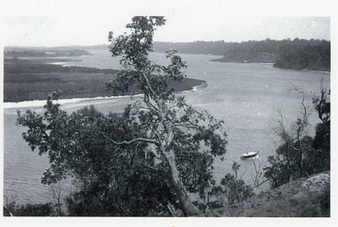
Photograph - Reeves Channel, 1915c
... Waterways ...Original in possession of descendant of Arthur Seagrove, teacher at Johnsonville School c1920.Black and white photograph of Reeves Channel, Gippsland Lakes, showing a launch in the Narrows below Jemmy's Point, Rigby Island and a distant view of Fraser Island and Flannagan Island opposite the steep cliffs of the mainland shore. Lakes Entrance Victoria'To Rit with love from Arthur' on backislands, waterways, topography -
 Lakes Entrance Historical Society
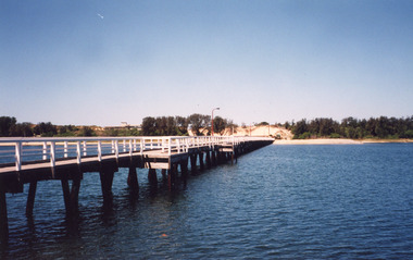
Photograph, Cunninghame Arm Footbridge, Lakes Entrance Victoria, 1999
... Waterways ...Colour photograph of the Cunninghame Arm Footbridge, showing the excavation of sand after removal of Kiosk, prior to construction of new Surf Lifesaving Clubrooms. Lakes Entrance Victoriabridges, waterways, construction -
 Lakes Entrance Historical Society
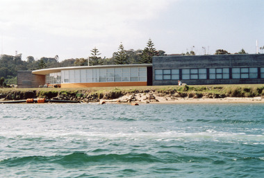
Photograph - Bullock Island, RMIT TAFE Educational Facility, Lakes Entrance Victoria, 2005
... Waterways ...Date made September 2005Colour photograph of the RMIT TAFE Educational Facility on Bullock Island, taken from Cunninghame Arm, in the back ground are communication towers on Kalimna Heights. The Kalimna escarpment contrasts with the low lying sand formation of Bullock Island. Lakes Entrance Victoriaislands, education, waterways -
 Eltham District Historical Society Inc
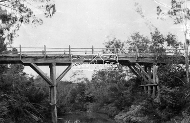
Photograph, Hurst's Bridge, c.1912
The area of Hurstbridge was originally known as Hurst’s-bridge after the timber bridge built over the Diamond Creek near Hurst’s station in late 1881/early 1882 on Hurstbridge-Arthurs Creek Road, Hurstbridge. It was built by John McDonald, of Arthur's Creek and was demolished and replaced in 1917 by a reinforced concrete arch bridge designed by John Monash. Part of a slide show presentation "Bridges & Waterways of the Shire" by Russell Yeoman to the 13 September 1989 Society meeting. The presentation included slides of historic photos from the Shire of Eltham Pioneers collections as well as several recent views. This photo forms part of a collection of photographs gathered by the Shire of Eltham for their centenary project book, Pioneers and Painters: 100 years of the Shire of Eltham" by Alan Marshall (1971). The collection of over 500 images is held in partnership between Eltham District Historical Society and Yarra Plenty Regional Library (Eltham Library) and is now formally known as 'The Shire of Eltham Pioneers Photograph Collection.' It is significant in being the first community sourced collection representing the places and people of the Shire's first one hundred years.Digital imageshire of eltham pioneers photograph collection, 1912, bridge, diamond creek (creek), hurstbridge, hurst's bridge -
![Wal Ives & Bert [Watson] at the outlet of the Kew Main Drain](/media/collectors/550653872162f11fb04854aa/items/61593ef27608a87f688412b1/item-media/61594a5a7608a87f68848c29/item-fit-380x285.jpg) Kew Historical Society Inc
Kew Historical Society IncPhotograph - Wal Ives & Bert [Watson] at the outlet of the Kew Main Drain, c.1900
Connor's Creek is/was one of two major waterways bisecting Kew, both of which empty into the Yarra River. Connor's Creek originates near the grounds of Genazzano FCJ College, which is one of the highest points in Kew. Until the 1930s, this was an open creek until a barrel drain - the Kew Main Drain - was constructed. As the creek ran through Kew it cut across a number of roads the maintenance of which was a continuing concern for Kew Councillors. In August 1864, the Council called for tenders to erect a stone culvert and embankment over Connor's Creek, on Belford-road. This may be the embankment on which the boys are sitting.Original, small photographic positive on card of two boys, identified by the donor as 'Wal Ives and Bert' [Albert Watson] sitting on bluestone capping above an outlet of Connor's Creek. To the left of the boys is a barrel drain which at that stage was the outlet for Connor's Creek near the Yarra River. The retaining wall is constructed of brick. In ink on photo: "Wal & Bert"connors creek -- kew (vic), wal ives, albert watson, belford road, yarra river -- kew (vic.), creeks -- kew (vic.), drains -- kew (vic.) -
 Sunbury Family History and Heritage Society Inc.
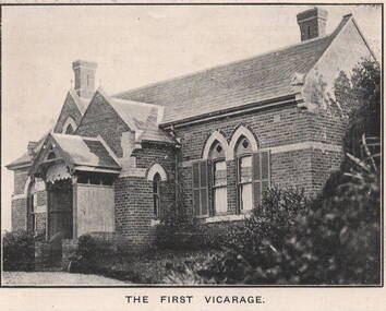
Photograph, 'Priorswood' Vicarage
The grand home is the first Church of England vicarage, 'Priorswood' to be built in Sunbury. It was sited at the east end of Station Street on Vicarage Hill and about a kilometre from St. Mary's Church in O'Shanassy Street. The distance between the two buildings presented a problem especially when the vicar had to negotiate a natural waterway across the lower end of Station Street after heavy rain. In 1914 a new Federation style vicarage was built adjacent to the church in O'Shanassy Street and was replaced in the 1960s with a more modern building, which was demolished in the 2020s to make way for 8 Oaks Community Centre.'Priorswood' is now a private home and has a local heritage listing.A print of a non-digital black and white photograph of a Gothic style brick home with a slate roof.'priorswood' vicarage, st. mary's church of england., sunbury, vicarages -
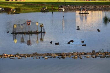 City of Ballarat
Artwork, other - Public Artwork, Home by Chris Mether, 2014
Home is a collection of birdhouses on floating islands using the iconic form of the human house - a pitched roof, square walls, windows and doors. This minimal form is often drawn by children; a dolls house, a cubby house, a letter-box or a chook house. Home creates a safe refuge for birds with the plants acting as a water filtration system. The exposed roots draw out pollutants, such as nitrogen, phosphorous and toxic metals, which have entered the waterway through urban run-off. The result is a beautiful sculptural experience and a healthier water system for all to enjoy. The artwork was funded by The City of Ballarat and The Victorian State Government.The work is of aesthetic significance to the people of BallaratHome is a collection of birdhouses on floating islands home, chris mether, studio mether, public art, ballarat, delecombe, wetlands -
Lakes Entrance Historical Society
Photograph, Eastwood Bros, 1889c
... Waterways ...Sepia photograph showing the just opened Entrance to Bass Strait. Sand not completely cleared from channel, buildings on dunes, dredge Wombat moored off Bullock Island. Rock groynes being built in lake. Lakes Entrance Victoriawaterways, islands, jetties, houses -
 Lakes Entrance Historical Society
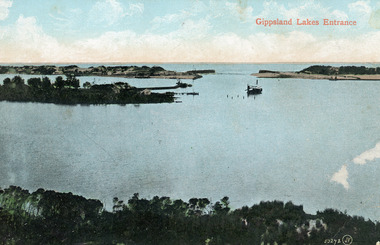
Photograph - The Entrance, 1910c
... Waterways ...Colour tinted photograph of the entrance from Bass Strait to the Gippsland Lakes. It shows the small village on the hummocks, Bullock Island with bathing boxes at western end, machinery building groyne's from Bullock Island. Boat in the water. Lakes Entrance VictoriaGippsland Lakes Entranceislands, ships and shipping, topography, waterways -
 Lakes Entrance Historical Society
Postcard - Township, 1930c
... Waterways ...Black and white small format postcard showing the township situated on the land between the Cunninghame Arm and North Arm. Lakes Entrance VictoriaLakes Entrance from Princes Highway (on back)bridges, township, topography, waterways -
 Lakes Entrance Historical Society
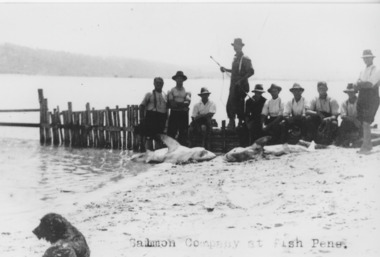
Photograph - Fish Pens, 1925
... Waterways ...Black and white photograph showing fishermen at fish pens. Shows ten men on beach beside fence, 2 or 3 large sharks on beach, spaniel dog on beach. Lakes Entrance Victoriafishing industry, boats and boating, fish, waterways -
 Lakes Entrance Historical Society
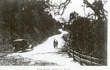
Photograph - Princes Highway Lakes Entrance, 1920c
... Waterways ...Black and white photograph of the newly formed Princes Highway. It shows the steep cutting into the Jemmys Point hill, the winding road, the post and rail fence, two people and car of the era on road. Lakes Entrance VictoriaNew Road Jemmy's Pointtopography, waterways, roads and streets, fences -
 Lakes Entrance Historical Society
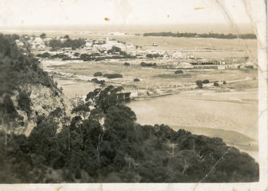
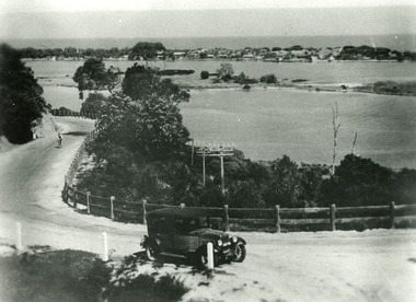
Photograph - Princes Highway Lakes Entrance, 1930c
... Waterways ...Black and white photograph of the Princes Highway as it winds around Jemmys Point. It shows a car parked in foreground, person on bicycle riding up hill, lake, Bullock Island and the township in distance. Lakes Entrance Victoria transport, roads and streets, waterways, township -
 Lakes Entrance Historical Society
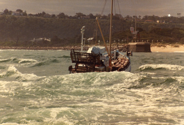
Photograph - Scallop Boat, 1980c
... Waterways ...May be 'Lady Jane'Colour photograph of an unidentified scallop fishing boat approaching the entrance channel after crossing the bar. Boat has bags of scallops stacked neatly on deck. Photograph taken from boat following. Lakes Entrance Victoriafishing industry, ships and shipping, waterways, ocean -
 Lakes Entrance Historical Society
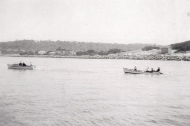
Photograph - Fishing Industry, 1945 c
... Waterways ...Black and white photograph of a small motor boat towing a fishing boat containing four men hauling a fishnet full of fish in the entrance channel, Lakes Entrance, Victoria.Bringing full fishnets into fishpens (on reverse of original)fishing industry, boats and boating, fish, waterways -
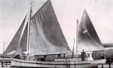 Lakes Entrance Historical Society
Photograph - Topsy, 1935 c
... Waterways ...Black and white photograph of the fishing ketch Topsy with all sails up, jetty in background, at Lakes Entrance, Victoria.fishing industry, fish, occupation, waterways