Showing 5977 items
matching 1980/81
-
 Greensborough Historical Society
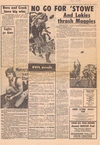
Newspaper clipping, Diamond Valley Leader, Greensborough Football Club articles, 1980s, 26/08/1980
Articles deal with the finals prospects of Greensborough Football Club in season 1980. 1981 article considers a proposal for Greensborough to leave the DVFL and join the VFA.Historical details of the local football club in the 1980s.One page from Diamond Valley News August 26th 1980. Includes photogaphs of players, articles and results from Elimination and Qualifying finals.Small article attached 'Borough considers VFA offer' hand written date 1981.greensborough football club, diamond valley football league, victorian football association, vfa, dvfl -
 Robin Boyd Foundation
Certificate, House insurance
Bonus certificates from various insurance companies for Camberwell and South Yarra homes.81 small certificates -
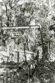
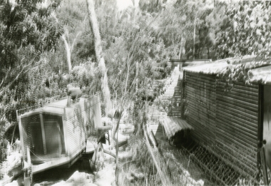
 Ringwood and District Historical Society
Photographs, 1979-80 MMBW pipe line project at Hubbard Reserve, North Ringwood � Compressor unit in backyard
Part of a 43-photo record of the MMBW�s engineering feat in drilling a 12 inch pipe line up to 40 feet deep through rock hardened by volcanic action associated with geological fault that occurs along the line. The work took place from October 1979 to May 1980 on the southern boundary of Hubbard Reserve, North Ringwood. The collection was presented to the Ringwood Historical Research Group by J Clarke on 9th June 1980.E560 N23 Jan 1980 A43 Compressor unit in backyard of 39 Burlock Avenue -
 Ringwood and District Historical Society
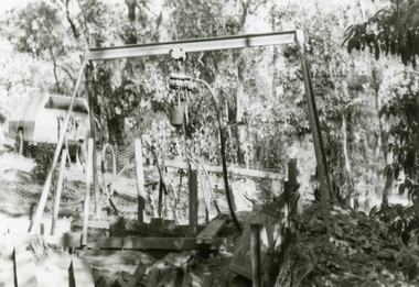
Photographs, 1979-80 MMBW pipe line project at Hubbard Reserve, North Ringwood � Closeup of revolving airwinch near Hibberd's house
Part of a 43-photo record of the MMBW�s engineering feat in drilling a 12 inch pipe line up to 40 feet deep through rock hardened by volcanic action associated with geological fault that occurs along the line. The work took place from October 1979 to May 1980 on the southern boundary of Hubbard Reserve, North Ringwood. The collection was presented to the Ringwood Historical Research Group by J Clarke on 9th June 1980.E560 N31 Jan 1980 A43 Closeup of revolving airwinch near Hibberd's house -
 Ringwood and District Historical Society
Photographs, 1979-80 MMBW pipe line project at Hubbard Reserve, North Ringwood � cars and caravan of gang
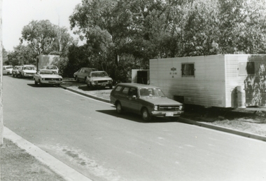
Part of a 43-photo record of the MMBW�s engineering feat in drilling a 12 inch pipe line up to 40 feet deep through rock hardened by volcanic action associated with geological fault that occurs along the line. The work took place from October 1979 to May 1980 on the southern boundary of Hubbard Reserve, North Ringwood. The collection was presented to the Ringwood Historical Research Group by J Clarke on 9th June 1980.E561 N5 Feb 1980 A43 Cars and caravans of the tunnelling gang in Burlock Ave -
 Ringwood and District Historical Society
Photographs, 1979-80 MMBW pipe line project at Hubbard Reserve, North Ringwood � MMBW compound in Evelyn Road
Part of a 43-photo record of the MMBW�s engineering feat in drilling a 12 inch pipe line up to 40 feet deep through rock hardened by volcanic action associated with geological fault that occurs along the line. The work took place from October 1979 to May 1980 on the southern boundary of Hubbard Reserve, North Ringwood. The collection was presented to the Ringwood Historical Research Group by J Clarke on 9th June 1980.E563 N2 12 April 1980 A43 MMBW compound in Evelyn Road gully -
 Ringwood and District Historical Society
Photographs, 1979-80 MMBW pipe line project at Hubbard Reserve, North Ringwood � Nissan backhoe digging for the broken mole
Part of a 43-photo record of the MMBW�s engineering feat in drilling a 12 inch pipe line up to 40 feet deep through rock hardened by volcanic action associated with geological fault that occurs along the line. The work took place from October 1979 to May 1980 on the southern boundary of Hubbard Reserve, North Ringwood. The collection was presented to the Ringwood Historical Research Group by J Clarke on 9th June 1980.E563 N4 12 April 1980 A43 Nissan backhoe digging for the broken mole -
 Ringwood and District Historical Society
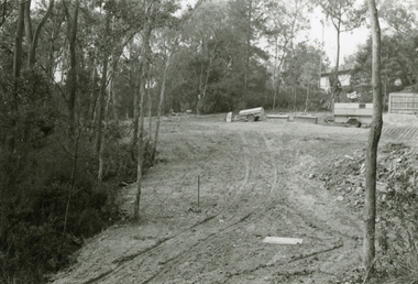
Photographs, 1979-80 MMBW pipe line project at Hubbard Reserve, North Ringwood � View east from Debbie Place
Part of a 43-photo record of the MMBW�s engineering feat in drilling a 12 inch pipe line up to 40 feet deep through rock hardened by volcanic action associated with geological fault that occurs along the line. The work took place from October 1979 to May 1980 on the southern boundary of Hubbard Reserve, North Ringwood. The collection was presented to the Ringwood Historical Research Group by J Clarke on 9th June 1980.E558 N29 13 May 1980 A43 View east from Debbie Place -
 Ringwood and District Historical Society
Photographs, 1979-80 MMBW pipe line project at Hubbard Reserve, North Ringwood � The manhole in the creek
Part of a 43-photo record of the MMBW�s engineering feat in drilling a 12 inch pipe line up to 40 feet deep through rock hardened by volcanic action associated with geological fault that occurs along the line. The work took place from October 1979 to May 1980 on the southern boundary of Hubbard Reserve, North Ringwood. The collection was presented to the Ringwood Historical Research Group by J Clarke on 9th June 1980.E563 1 April 1980 A43 The manhole in the creek, waiting until boring is finished. -
 Whitehorse Historical Society Inc.
Clothing - Blouse, circa 1980
Worn by Margaret Skey in 1980's1980's black polyester blouse with yoke and tie neckline. gathered sleeves to small cuff. Buttons are round black plastic to neck (six) and on each cuff. Size 14 (see NA3766 red suit with which blouse was worn.)costume, female -
National Wool Museum
Calendar
Dennys Strachan Mercantile Limited calendar for the 1980-81 Victorian wool sales season.wool sales wool brokering, dennys strachan mercantile limited, wool sales, wool brokering -
 Stawell Historical Society Inc
Photograph, Individual Portrait, 1980
asked to remove glasses for PhotoColour Photograph: female wearing red and white floral blouse1980 -
![Artwork, other - [Boy's Head] 1969, Noel Counihan](/media/collectors/5f33390821ea670db8ae2a22/items/5f7d36e50890e70e6074752b/item-media/5fdc11e614f04b0358cccf04/item-fit-380x285.jpg) Bass Coast Shire Council - Robert Smith Collection
Bass Coast Shire Council - Robert Smith CollectionArtwork, other - [Boy's Head] 1969, Noel Counihan
Australia 1913 - 1986Drypoint AP s.81Signed, dated and editioned. Inscribed 'For Bev' -
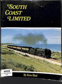 Victorian Railway History Library
Book, Australian Railway Historical Society (S.A. Division) Inc, South Coast Limited, 1972
The history of the railway to Victor Harbor in South Australia from S.A.R. ownership to a tourist railway.ill, maps, p.81.non-fictionThe history of the railway to Victor Harbor in South Australia from S.A.R. ownership to a tourist railway.railroad construction - south australia - history, railroad operations - south australia - history -
 Ringwood and District Historical Society
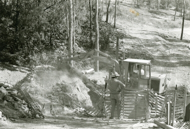
Photographs, 1979-80 MMBW pipe line project at Hubbard Reserve, North Ringwood � Work on boring mole pit
Part of a 43-photo record of the MMBW�s engineering feat in drilling a 12 inch pipe line up to 40 feet deep through rock hardened by volcanic action associated with geological fault that occurs along the line. The work took place from October 1979 to May 1980 on the southern boundary of Hubbard Reserve, North Ringwood. The collection was presented to the Ringwood Historical Research Group by J Clarke on 9th June 1980.E560 N22Jan 1980 A43 Work on mole boring pit in 39 Burlock Avenue backyard -
 Ringwood and District Historical Society
Photographs, 1979-80 MMBW pipe line project at Hubbard Reserve, North Ringwood � First hole in Lot 8
Part of a 43-photo record of the MMBW�s engineering feat in drilling a 12 inch pipe line up to 40 feet deep through rock hardened by volcanic action associated with geological fault that occurs along the line. The work took place from October 1979 to May 1980 on the southern boundary of Hubbard Reserve, North Ringwood. The collection was presented to the Ringwood Historical Research Group by J Clarke on 9th June 1980.E561 N2 Feb 1980 A43 Final hole in lot 8 (no. 41) at the corner of Chalkly's -
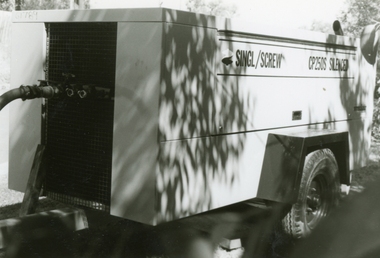 Ringwood and District Historical Society
Photographs, 1979-80 MMBW pipe line project at Hubbard Reserve, North Ringwood � compressor
Part of a 43-photo record of the MMBW�s engineering feat in drilling a 12 inch pipe line up to 40 feet deep through rock hardened by volcanic action associated with geological fault that occurs along the line. The work took place from October 1979 to May 1980 on the southern boundary of Hubbard Reserve, North Ringwood. The collection was presented to the Ringwood Historical Research Group by J Clarke on 9th June 1980.E561 N6 Feb 1980 A43 Compressor of the tunnelling gang on the sewer line in Burlock Ave -
 Ringwood and District Historical Society
Photographs, 1979-80 MMBW pipe line project at Hubbard Reserve, North Ringwood � Air track drill rig
Part of a 43-photo record of the MMBW�s engineering feat in drilling a 12 inch pipe line up to 40 feet deep through rock hardened by volcanic action associated with geological fault that occurs along the line. The work took place from October 1979 to May 1980 on the southern boundary of Hubbard Reserve, North Ringwood. The collection was presented to the Ringwood Historical Research Group by J Clarke on 9th June 1980.E561 N19 3 March 1980 A43 Air track drill rig in position as in N18 -
 Ringwood and District Historical Society
Photographs, 1979-80 MMBW pipe line project at Hubbard Reserve, North Ringwood � Drill rig
Part of a 43-photo record of the MMBW�s engineering feat in drilling a 12 inch pipe line up to 40 feet deep through rock hardened by volcanic action associated with geological fault that occurs along the line. The work took place from October 1979 to May 1980 on the southern boundary of Hubbard Reserve, North Ringwood. The collection was presented to the Ringwood Historical Research Group by J Clarke on 9th June 1980.E561 N17 3 March 1980 A43 Powder-monkey marks out the spots for holes -
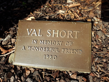 Vision Australia
Plaque - Object, Val Short plaque
Located in the garden at Kooyong, at the intersection of the path to Talbot Crescent and the path leading to the Club house, this plaque marks the contribution of Val Short, a well liked volunteer who died in 1980. Previously this plaque was laid in the gardens outside Paterson Hall (Rose Garden?)Metal plaque with metal lettering in garden bed.Val Short In Memory of A Wonderful Friend 1980association for the blind, nameplate -
 Ringwood and District Historical Society
Photographs, 1979-80 MMBW pipe line project at Hubbard Reserve, North Ringwood � Air winch over the hole in the corner of Chalkley's
Part of a 43-photo record of the MMBW�s engineering feat in drilling a 12 inch pipe line up to 40 feet deep through rock hardened by volcanic action associated with geological fault that occurs along the line. The work took place from October 1979 to May 1980 on the southern boundary of Hubbard Reserve, North Ringwood. The collection was presented to the Ringwood Historical Research Group by J Clarke on 9th June 1980.E561 N1 Feb 1980 A43 Air winch over the hole in the corner of Chalkley's (lot 8) -
 Ringwood and District Historical Society
Photographs, 1979-80 MMBW pipe line project at Hubbard Reserve, North Ringwood � Viewing east from Debbie Place
Part of a 43-photo record of the MMBW�s engineering feat in drilling a 12 inch pipe line up to 40 feet deep through rock hardened by volcanic action associated with geological fault that occurs along the line. The work took place from October 1979 to May 1980 on the southern boundary of Hubbard Reserve, North Ringwood. The collection was presented to the Ringwood Historical Research Group by J Clarke on 9th June 1980.E568 N18 13 May 1980 A43 Viewing east from ridge above Debbie Place -
 Ringwood and District Historical Society
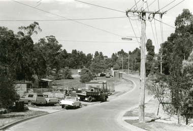
Photographs, 1979-80 MMBW pipe line project at Hubbard Reserve, North Ringwood � View from Debbie Place, preliminary sewer work
Part of a 43-photo record of the MMBW�s engineering feat in drilling a 12 inch pipe line up to 40 feet deep through rock hardened by volcanic action associated with geological fault that occurs along the line. The work took place from October 1979 to May 1980 on the southern boundary of Hubbard Reserve, North Ringwood. The collection was presented to the Ringwood Historical Research Group by J Clarke on 9th June 1980.E561 N13 28 Feb 1980 A43 View from Debbie Place, preliminary sewer work -
 Ringwood and District Historical Society
Photographs, 1979-80 MMBW pipe line project at Hubbard Reserve, North Ringwood � First hole west of bore hole at 39 Burlock Avenue
Part of a 43-photo record of the MMBW�s engineering feat in drilling a 12 inch pipe line up to 40 feet deep through rock hardened by volcanic action associated with geological fault that occurs along the line. The work took place from October 1979 to May 1980 on the southern boundary of Hubbard Reserve, North Ringwood. The collection was presented to the Ringwood Historical Research Group by J Clarke on 9th June 1980.E561 N9 Feb 1980 A43 First hole west of bore hole at 39 Burlock Avenue -
 Ringwood RSL Sub-Branch
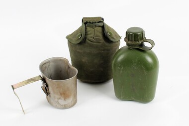
Equipment, Water Bottle, Stokes Australisia Ltd
00094.1 Plastic water Bottle Viietnam War Period Dark Green in colour 00094.2 Padded water bottle cover Marked CANTIS 81 Dark Green 00094.3 Aluminiun Cup , cooking vessel mess tin marked 1986 and Broad Arrow00094.1 8465 - 71 - 108 - 8703 Marked Dubol 2187441 00094.2. 8465 - 66 - 0639564 CANTIS 81 00094.3 Stokes Australasia Ltd. 8465 -66 - 058 - 5567 -
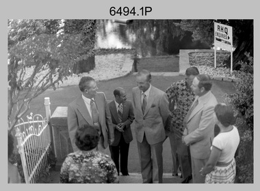
 Ringwood and District Historical Society
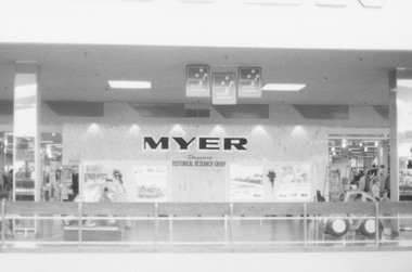
Photograph, Ringwood Historical Research Group display in Eastland Foyer, Ringwood - 1981, Feb-81
Ringwood Historical Research Group (RHRG) display in Eastland Foyer.Written on back of photograph, "2/81. RHRG display - Eastland Foyer". -
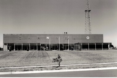 Whitehorse Historical Society Inc.
Photograph - Channel O Television Studio, Channel O Television Studio
Black and white photograph of Channel O in 1964 . Opened by Reg Ansett and changed to ATV10 in January 1980.Black and white photograph of Channel O in 1964 . Opened by Reg Ansett and changed to ATV10 in January 1980.channel 0 tv studios, hawthorn road east burwood, tv studio -
 Bendigo Military Museum
Photograph - MAJGEN Nicholson - Director DMA to the Army Survey Regiment, Bendigo, 1980
This set of nine black and white photographs were taken during the visit to the Army Survey Regiment, Bendigo by the Director of the USA’s Defense Mapping Agency –MAJGEN William L. Nicholson III, on the 7th of February 1980. He was accompanied by US Army COL W.P. ‘Pinky' Holmes and an unidentified Major from the USAF. It is not known if their wives or partners were in attendance.This set of nine black and white photographs were taken during the visit to the Army Survey Regiment, Bendigo by the Director of the USA’s Defense Mapping Agency –MAJGEN William L. Nicholson III, on the 7th of February 1980. The photographs are on 35mm negative film and scanned at 96 dpi. They are part of the Army Survey Regiment’s Collection. .1) - Photo, black & white, 1980. L to R: unidentified civilian (facing away), MAJGEN William L. Nicholson III, MAJ Sam Schwartz US Exchange, CO LTCOL Bob Skitch, D-SVY COL NRJ Hillier, MAJ Don Swiney MBE, Mrs Glen Swiney. .2) - Photo, black & white, 1980. L to R: unidentified civilian & Mrs Glen Swiney, (facing away), MAJGEN William L. Nicholson III, CO LTCOL Bob Skitch, unidentified civilian (facing away). .3) - Photo, black & white, 1980. L to R: unidentified visiting USA officer, MAJ Sam Schwartz US Exchange. .4) - Photo, black & white, 1980. L to R: CAPT Peter Ralston, CAPT Dennis Puniard, CAPT Bob Roche, MAJGEN William L. Nicholson III, CO LTCOL Bob Skitch. .5) - Photo, black & white, 1980. L to R: unidentified (x4), MAJ Sam Schwartz US Exchange, unidentified, CAPT Bob Roche, unidentified (x3), MAJ Paddy Strunks, unidentified, Mrs Glen Swiney, unidentified civilian (facing away)., CAPT Don Maskew, unidentified civilian. .6) - Photo, black & white, 1980. L to R: MAJ Peter Eddy, D-SVY COL NRJ Hillier, CO LTCOL Bob Skitch, MAJGEN William L. Nicholson III, remainder unidentified. .7) - Photo, black & white, 1980. L to R: MAJGEN William L. Nicholson III, CO LTCOL Bob Skitch. .8) - Photo, black & white, 1980. L to R: ADJT CAPT John Harrison, unidentified civilian. .9) - Photo, black & white, 1980. L to R: Mrs Glen Swiney, unidentified civilians (x2).No personnel or civilians are identifiedroyal australian survey corps, rasvy, army survey regiment, army svy regt, fortuna, asr -
 Ringwood and District Historical Society
Photographs, 1979-80 MMBW pipe line project at Hubbard Reserve, North Ringwood � View along line work in Hibberd's and Chalkley's
Part of a 43-photo record of the MMBW�s engineering feat in drilling a 12 inch pipe line up to 40 feet deep through rock hardened by volcanic action associated with geological fault that occurs along the line. The work took place from October 1979 to May 1980 on the southern boundary of Hubbard Reserve, North Ringwood. The collection was presented to the Ringwood Historical Research Group by J Clarke on 9th June 1980.E560 N27 Jan 1980 A43 View along line work in Hibberd's and Chalkley's (lot 9 and 8) -
 Ringwood and District Historical Society
Photographs, 1979-80 MMBW pipe line project at Hubbard Reserve, North Ringwood � Line of sewer work with mole power pack near Hibberd's shed
Part of a 43-photo record of the MMBW�s engineering feat in drilling a 12 inch pipe line up to 40 feet deep through rock hardened by volcanic action associated with geological fault that occurs along the line. The work took place from October 1979 to May 1980 on the southern boundary of Hubbard Reserve, North Ringwood. The collection was presented to the Ringwood Historical Research Group by J Clarke on 9th June 1980.E560 N28 Jan 1980 A43 Line of sewer work with mole power pack near Hibberd's shed