Showing 5508 items
matching albert road
-
 Ballarat Tramway Museum
Photograph - Digital image Set of 10, 1971
Yields information about Ballarat Tramways and trams prior to the closure of the tramway system.Set of 10 digital images of Ballarat trams prior to closure, scanned from original slides by Stuart Lodington, 1971 prior to closure of the system. .1 - No. 27 at Lydiard St North terminus with passengers alighting/boarding and an enthusiast about to turn the pole. .2 - No. 27 and No. 30 Skipton St at the Bell St Loop. .3 - No. 13 at the Mt Pleasant terminus, showing destination of Gardens via Drummond St North. .4 - Crews of No. 31 (Conductor and Driver) reversing pole of No. 31 at the depot. .5 - No. 11 inbound on Victoria St. .6 - Night view of a tram at a terminus. .7 - Scrubber on 0 road at the depot .8 - No. 14 at Gardens Loop with another tram behind and the driver standing in the front of the tram. .9 - No. 13 (Mt Pleasant) inbound in Sturt St with 14 behind. .10 - No. 26 northbound to Lydiard St north, about to cross Albert St Sebastopol with the SSW shop in the background. trams, tramways, sebastopol, lydiard st nth, skipton st, bell st, mt pleasant, victoria st, depot, albert st, tram 27, tram 30, tram 13, tram 11, scrubber, tram 14, tram 26 -
 Ballarat Tramway Museum
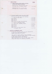
document - Typed Notes, "Track Grades" and "Tramway Route Distances", 1953
Yields information about the curves and grades and track distances in Ballarat on its tramways.Typed notes titled 1. - "Tramway Route Distances" detailing the distances in Ballarat over the various routes and within the city, often measured from building lines, provided in chains. Typed 12/3/1953, initials "WM" 2 - "Track Grades" - for Sturt St, South track between Albert and Lydiard St (south side), North side (between Courier Office and Lydiard St", Victoria St, east from Main Road, location of sharpest curve (Main Road into Barkly St), Dawson St crossover, Contained within Reg Item 5507 - Foolscap binder with green covers, black binding edge and metal clips. track, ballarat -
 Ballarat Tramway Museum
Photograph - Digital image Set of 10, Tony Smith, 1971
Yields information about Ballarat Tramways and trams prior to the closure of the tramway system.Set of 10 digital images of Ballarat trams prior to closure, scanned from original slides by Tony Smith, 1971 prior to closure of the system. .1 - 41 and four other single truckers in the City Loop - Sturt St - has Dickins, Gear Chemist, Egments - Hartleys in the background. .2 - 33 northbound in Drummond St North with a large semi trailer behind it. .3 - Scrubber tram on 0 road at the depot. .4 - 43 in Lydiard St North .5 - 37? at Sebastopol terminus with the Royal Hotel in the Background. .6 - 37, Albert St, south of Ophir St crossover, northbound - photo not in focus. .7 - 37 at the Grey St loop, northbound. .8 - 37 and 34? - Urquhart St loop? - not in focus. .9 - 11 - Sturt St, showing Victoria St destination. .10 - 37 - climbing the Lydiard St hill, tram showing Sebastopol.trams, tramways, city loop, sturt st, lydiard st north, drummond st nth, depot, grey st loop, albert st, urquhart st, tram 41, tram 33, tram scrubber, tram 43, tram 37, tram 34, tram 11 -
 Ballarat Tramway Museum
Album - Photo Album, c1970
Set of 16 photos of Ballarat tram system taken 1970c on a tour by an unknown Qld based person.Photo album containing 16 colour prints. Photo album has heavy card covers, covered in black textured plastic containing 12 clear plastic photo sleeves held with a white comb binder. Photos of Ballarat prior to closure, c1970. Photographer unknown. Donated by Peter Hyde of Brisbane Tramway Museum to BTM 3/2/2010, from a deceased estate. Photos apparently taken on a tram tour. .1 - No. 42 and a single trucker inbound in Sturt St. .2 - taken from tram ascending Bakery St hill in Victoria St. .3 - End of No. 42, with the destination "Haddon St via Drummond Nth" .4 - No. 11 and 42 in Lydiard St Nth, near the railway station. No. 11 showing special. .5 - photo of three people on the tour. .6 - Trams reversing at the Victoria St terminus .7 - ditto .8 - 11, 42 and 12? in Lydiard St North by railway station. .9 - Three trams at Sebastopol terminus. .10 - View in Albert St Sebastopol looking north along the track on the side of the road. .11 - View of the tram crossing in Albert St. .12 - 27 and 42 crossing Albert St Sebastopol. .13 - View of Albert St from the tram, north of the crossing looking at the reserved track 14. - Lydiard St North looking south .15 - 42 at the railway level crossing. .16 - View south of the railway level crossing, three trams, with passengers alighting.trams, tramways, ballarat, albert st, sebastopol, victoria st, sturt st, lydiard st nth, railway crossing -
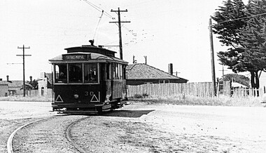 Ballarat Tramway Museum
Photograph - Digital image, Late 1950's
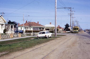
... the appearance and details about No. 30 and the Albert St road crossing ...Yields information the appearance and details about No. 30 and the Albert St road crossing in the late 1950's, in particular the road surface and the buildings.Digital scan from the Ben Parle collection of SEC No. 30 crossing Albert St Sebastopol, with the destination of Sebastopol - in particular the road surface and the buildings. Photo 1950's or early 1960 prior to introduction of dash canopy lighting. Has the houses either side of the street in view. Photo received with the Ben Parle slides 09/2004. trams, tramways, sebastopol, albert st, tram 30 -
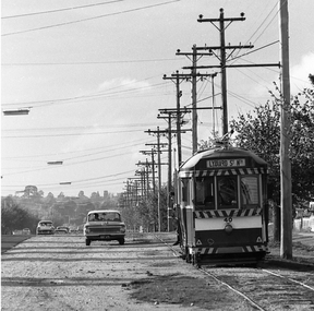 Ballarat Tramway Museum
Photograph - Digital image, Peter Bruce, "No. 40 and Valiant", 1970s
Yields information about Albert St Sebastopol and the way the tram related to the roadway.Digital image of No. 40 southbound in Albert St Sebastopol with a Valiant motor car parked on the gravel portion of the road. Note the destination on the tram, Lydiard St North, either reset to early or forgot to change it. Photo taken by Peter Bruce 1970's and 1971, prior to the closure of the Ballarat tramway system. Peter's Title of image: "No. 40 and Valiant"trams, tramways, albert st, sebastopol, tram 40 -
 Otway Districts Historical Society
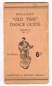
Booklet, "Old Time" Dance Guide
The dance guide contains set dances, the Alberts, the First Set; the Lancers, the Fitzroys, the Valetta where couples dance side by side), the Schottische, and the Two Step, prepared by "M.C.". Mullens' "Old Time" Dance Guide. 7th edition. 6d. Robertson and Mullens; Melbourne (Vic); nd. 2p. Soft cover.mullens'; dance guide; -
 Otway Districts Historical Society
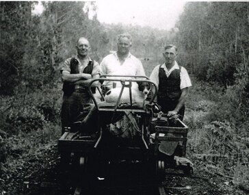
Photograph, Albert Denning, Colac track gang near Kawarren, c.1950
In 1955 staff numbers were reduced to an absolute minimum with one track gang at Beech Forest and one at Colac, one of whose members resided at Gellibrand. No new sleepers were issued to the track gangs after 1955/56, cut down ones being used instead. Albert Denning, the son of a Gellibrand selector, worked at Driver's planing mill and Hitt's Lardner mill before joining Victorian Railways in 1928 as an engine cleaner at Beech Forest and Crowes, the last one in both places. He later became a track repairer at Gellibrand and worked with this and the Colac track gang until 1962. Bill Jamieson was a track repairer on the Colac-Gellibrand gang from the 1950s until 1962, and witnessed the official policy of minimum maintenance in the last years of the line.B/W. 201mm x 254mm. In c.1950, the Colac track gang near Kawarren, featuring, from left to right, Bill Jamieson, Albert Denning, and Don Loury on an NKS motor trolley..colac; kawarren; railways; track gangs; -
 Running Rabbits Military Museum operated by the Upwey Belgrave RSL Sub Branch
FELLOWS A.V
Albert Victor Fellows S/No. #20929 - letter home, service record, etc.ww1, army -
 Running Rabbits Military Museum operated by the Upwey Belgrave RSL Sub Branch
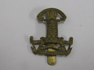
Badge
Cap badge - Leicestershire Prince Albert's Own Yeomen. South Africa 1900badge/buttons, army -
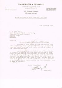 Bendigo Historical Society Inc.
Document - MCCOLL, RANKIN AND STANISTREET COLLECTION: NELL GWYNNE SYNCLINE
Manilla folder of documents relating to the Nell Gwynne Syncline Mining lease. Mentioned are Lease No.'s 10875 and 10903 which is in the Empire Road Stray Street area; R. Lethlean's Sluicing Claim; Albert Selisky has permissive Occupancy on ¼ acre; New Chum Syncline; Liddell's Chenical and Metallurgical Works; Arum Dredging Development NL. Application for a Hydraulic Sluicing Lease; Transfer of lease No. 10903, from H.J. Leed to North Nell Gwynne Gold Mines NL; Application form for the Nell Gwynne Syncline Co.. Application for leases 10945 and 10946; Nell Gwynne Syncline option to purchase lease 10945 for £1,000; Consent from Minna Matilda Lawson for inclusion of part of allotment 268 in lease No. 10875.Dickson & Tadgell Charted Accountants, 95 Queen Street, Melbourne C1gold, mining, land application, nell gwymme syncline, gold mines, bendigo -
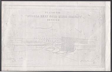 Bendigo Historical Society Inc.
Document - VICTORIA REEF GOLD MINES COMPANY BENDIGO PLAN
Photocopy of a Plan of the Victoria Reef Gold Mines Company, Bendigo. Shaded area is the Victoria Reef Gold Mines Company Lease No. 2 and Lease No. 3. The gullies are named Happy Valley, Long, Derwent, Providence and Ironbark Gullies. The reefs are: Western Victoria, Victoria, Eastern Victoria and Prince Albert Reef. Between the Eastern Victoria Reef and the Prince Albert Reef is the White Lead. Mount Korong Road is at the bottom of the plan. Other Leaseholders are: Burrows, Wybrant, Ballerstedt, Jackson,Roberts & Co, Ashley, Grant, ?rpe, ?eau, Woodward, Coath, Taylor, Cranshaw, Roberts, Gould & Co, Midway, Witscheibe, Endeavour Co, Albert Co, Ballerstedt & Son, Late Iron Bark Quartz Mining Co, McDougall, Specimen Hill Co, Hygrect?, Wheadon, Evans and Bannerman. Signed by H. B. Nicholas. Location of Ballerstedt, Luffsman, Midway Co, Witscheibe and Rae & Co engine locations. Hills are shown as hatch shading. Written at the bottom left ocrner is: Accompanying prospectus issued in Nov. 1859. Signed H.B. Nicholas.plan, bendigo, victoria reef gold mines company, victoria reef gold mines company bendigo - plan, h b nicholas, burrows, wybrant, ballerstedt, jackson, roberts & co, ashley, grant, ?rpe, ?eau, woodward, coath, taylor, cra-shaw, roberts, gou-d & co, midway, witscheibe, endeavour co, albert co, ballerstedt & son, late iron bark quartz mining co, mcdougall, specimen hill co, hyo?, wheadon, evans, bannerman. -
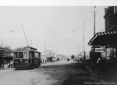 Ballarat Tramway Museum
Photograph - Black & White Photograph/s, c1920
Yields information about MMTB No. 66 which later became Geelong No. 28.Black and white photograph - copy photograph from a postcard of MMTB or PMTT 66 outbound in Whitehorse Road Balwyn. Tram has the destination of Mont Albert, route 15. In the background is the Balwyn shopping centre. The tram became Geelong No. 25 and then Geelong 28 in 1951. See April 1981 issue of Trolley Wire. In the bottom right hand corner titled "Whitehorse Road, Balwyn C1920s"trams, tramways, whitehorse road, balwyn, pmtt, mmtb, j class, geelong, tram 66 -
Bendigo Historical Society Inc.
Photograph - STRATHFIELDSAYE SHIRE BAND, early 1900's
Sepia photograph of the Strathfieldsaye Shire Band, showing thireen players and one leader. Many have ribboned hat bands, watch chains, Alberts, visible on left and right outer and centre members. All are suited and wearing hats. . Two wagons visible behind picket fence in background. Five members in front row are seated. On back in pencil ' from Mrs. Lowndes, McIvor Road. Back row Morgan Mulcare 1886, Harry Weiness, Joe Lewis, Jack Gladen 1870, Maurice Lewis 1884, Jim Griffin 1873/77/78 Jack Weiness, Ben Griffen, Frank McLean, Sitting : William Somerville 1858/79/82/85 Unknown, Thomas Somerville 1882/83 , Harry Manser 1885, Michael Sullivan 1867/68 MORE INFORMATION ON SHEETS BEHIND PHOTOR. Dermer Smith, Bull Street.organization, club/society, strathfieldsaye shire band -
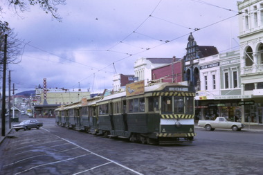
 Ballarat Tramway Museum
Slide - Set of three slides - Sebastopol line, Paul Jenkins, September 1971
Set of three colour slides showing Ballarat tram 12 inbound in Albert St Sebastopol. The 3rd slides shows the tram crossing the road.Demonstrates tram operations on the Sebastopol line prior to closure.Set of three Kodachrome cardboard slides."Last Tram"tramways, ballarat, trams, tram 12, albert st., sebastopol -
 Ballarat Tramway Museum
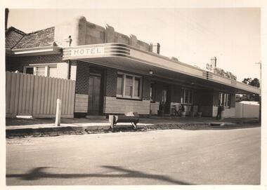
Photograph - Black & White Photograph/s, Wal Jack
Black & white photo of 'Red Lion Hotel', Main Road, Ballarat East, c1940's to 1950's(early). 'Mrs. A. Mong' on rear of photo. From the Mong family (Paul a member of the Museum) a relative was the proprietor of the hotel until the early 50's. On Kodak print paper, Velox. Reference: Mr. Albert Mong, Norman St. Ballarat. Reimaged 17/7/2017 both front and back.in machine stamp '6320'trams, tramways, ballarat hotels, mong family, hotels -
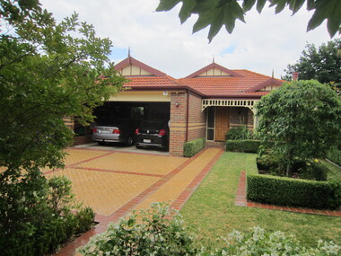
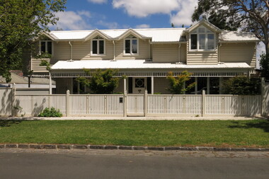
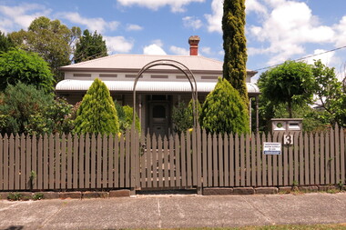
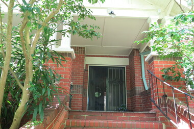
 Surrey Hills Historical Society Collection
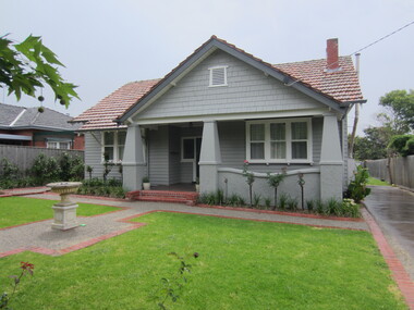
Photograph - 109 Middlesex Road, Surrey Hills, The Street Where You Live Project
Photos documenting this address as part of a photographic series undertaken by volunteer photographers during 2013 and 2014 for The Street Where You Live Project. This was organised through the Surrey Hills Neighbourhood Centre and covered the postcode 3127 in the cities of Boroondara and Whitehorse.These photos provide a snapshot of real estate in the suburbs of Mont Albert and Surrey Hills during a period of rapid change with many properties on large blocks demolished to create higher density residential development or renewal of single dwellings. At particular risk were properties not covered by heritage overlays, in particular interwar housing and post 1950's housing. -
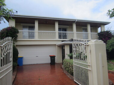
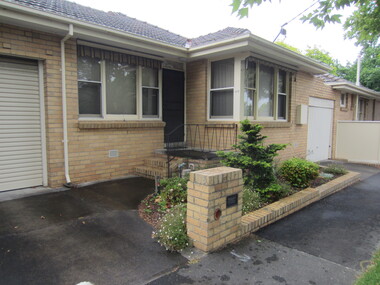
 Surrey Hills Historical Society Collection
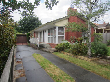
Photograph - 110 Middlesex Road, Surrey Hills, The Street Where You Live Project
Photos documenting this address as part of a photographic series undertaken by volunteer photographers during 2013 and 2014 for The Street Where You Live Project. This was organised through the Surrey Hills Neighbourhood Centre and covered the postcode 3127 in the cities of Boroondara and Whitehorse.These photos provide a snapshot of real estate in the suburbs of Mont Albert and Surrey Hills during a period of rapid change with many properties on large blocks demolished to create higher density residential development or renewal of single dwellings. At particular risk were properties not covered by heritage overlays, in particular interwar housing and post 1950's housing. -
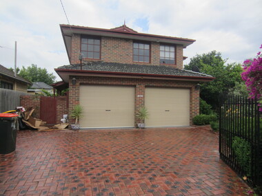
 Surrey Hills Historical Society Collection
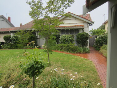
Photograph - 111 Middlesex Road, Surrey Hills, The Street Where You Live Project
Photos documenting this address as part of a photographic series undertaken by volunteer photographers during 2013 and 2014 for The Street Where You Live Project. This was organised through the Surrey Hills Neighbourhood Centre and covered the postcode 3127 in the cities of Boroondara and Whitehorse.These photos provide a snapshot of real estate in the suburbs of Mont Albert and Surrey Hills during a period of rapid change with many properties on large blocks demolished to create higher density residential development or renewal of single dwellings. At particular risk were properties not covered by heritage overlays, in particular interwar housing and post 1950's housing. -
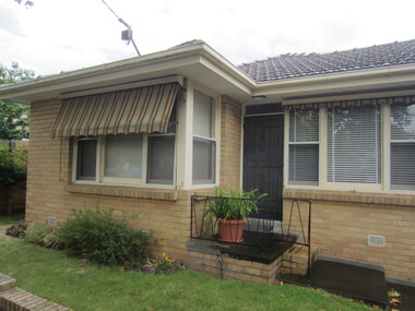
 Surrey Hills Historical Society Collection
Photograph - 112 Middlesex Road, Surrey Hills, The Street Where You Live Project
Photos documenting this address as part of a photographic series undertaken by volunteer photographers during 2013 and 2014 for The Street Where You Live Project. This was organised through the Surrey Hills Neighbourhood Centre and covered the postcode 3127 in the cities of Boroondara and Whitehorse.These photos provide a snapshot of real estate in the suburbs of Mont Albert and Surrey Hills during a period of rapid change with many properties on large blocks demolished to create higher density residential development or renewal of single dwellings. At particular risk were properties not covered by heritage overlays, in particular interwar housing and post 1950's housing. -
 Surrey Hills Historical Society Collection
Photograph - 113 Middlesex Road, Surrey Hills, The Street Where You Live Project
Photos documenting this address as part of a photographic series undertaken by volunteer photographers during 2013 and 2014 for The Street Where You Live Project. This was organised through the Surrey Hills Neighbourhood Centre and covered the postcode 3127 in the cities of Boroondara and Whitehorse.These photos provide a snapshot of real estate in the suburbs of Mont Albert and Surrey Hills during a period of rapid change with many properties on large blocks demolished to create higher density residential development or renewal of single dwellings. At particular risk were properties not covered by heritage overlays, in particular interwar housing and post 1950's housing. -
 Surrey Hills Historical Society Collection
Photograph - 114 Middlesex Road, Surrey Hills, The Street Where You Live Project
Photos documenting this address as part of a photographic series undertaken by volunteer photographers during 2013 and 2014 for The Street Where You Live Project. This was organised through the Surrey Hills Neighbourhood Centre and covered the postcode 3127 in the cities of Boroondara and Whitehorse.These photos provide a snapshot of real estate in the suburbs of Mont Albert and Surrey Hills during a period of rapid change with many properties on large blocks demolished to create higher density residential development or renewal of single dwellings. At particular risk were properties not covered by heritage overlays, in particular interwar housing and post 1950's housing. -
 Surrey Hills Historical Society Collection
Photograph - 115 Middlesex Road, Surrey Hills, The Street Where You Live Project
Photos documenting this address as part of a photographic series undertaken by volunteer photographers during 2013 and 2014 for The Street Where You Live Project. This was organised through the Surrey Hills Neighbourhood Centre and covered the postcode 3127 in the cities of Boroondara and Whitehorse.These photos provide a snapshot of real estate in the suburbs of Mont Albert and Surrey Hills during a period of rapid change with many properties on large blocks demolished to create higher density residential development or renewal of single dwellings. At particular risk were properties not covered by heritage overlays, in particular interwar housing and post 1950's housing. -
 Surrey Hills Historical Society Collection
Photograph - 116 Middlesex Road, Surrey Hills, The Street Where You Live Project
Photos documenting this address as part of a photographic series undertaken by volunteer photographers during 2013 and 2014 for The Street Where You Live Project. This was organised through the Surrey Hills Neighbourhood Centre and covered the postcode 3127 in the cities of Boroondara and Whitehorse.These photos provide a snapshot of real estate in the suburbs of Mont Albert and Surrey Hills during a period of rapid change with many properties on large blocks demolished to create higher density residential development or renewal of single dwellings. At particular risk were properties not covered by heritage overlays, in particular interwar housing and post 1950's housing. -
 Surrey Hills Historical Society Collection
Photograph - 117 Middlesex Road, Surrey Hills, The Street Where You Live Project
Photos documenting this address as part of a photographic series undertaken by volunteer photographers during 2013 and 2014 for The Street Where You Live Project. This was organised through the Surrey Hills Neighbourhood Centre and covered the postcode 3127 in the cities of Boroondara and Whitehorse.These photos provide a snapshot of real estate in the suburbs of Mont Albert and Surrey Hills during a period of rapid change with many properties on large blocks demolished to create higher density residential development or renewal of single dwellings. At particular risk were properties not covered by heritage overlays, in particular interwar housing and post 1950's housing. -
 Surrey Hills Historical Society Collection
Photograph - 118 Middlesex Road, Surrey Hills, The Street Where You Live Project
Photos documenting this address as part of a photographic series undertaken by volunteer photographers during 2013 and 2014 for The Street Where You Live Project. This was organised through the Surrey Hills Neighbourhood Centre and covered the postcode 3127 in the cities of Boroondara and Whitehorse.These photos provide a snapshot of real estate in the suburbs of Mont Albert and Surrey Hills during a period of rapid change with many properties on large blocks demolished to create higher density residential development or renewal of single dwellings. At particular risk were properties not covered by heritage overlays, in particular interwar housing and post 1950's housing. -
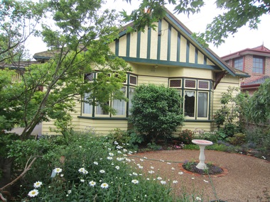
 Surrey Hills Historical Society Collection
Photograph - 1 St Georges Avenue, Mont Albert, The Street Where You Live Project
Photos documenting this address as part of a photographic series undertaken by volunteer photographers during 2013 and 2014 for The Street Where You Live Project. This was organised through the Surrey Hills Neighbourhood Centre and covered the postcode 3127 in the cities of Boroondara and Whitehorse.These photos provide a snapshot of real estate in the suburbs of Mont Albert and Surrey Hills during a period of rapid change with many properties on large blocks demolished to create higher density residential development or renewal of single dwellings. At particular risk were properties not covered by heritage overlays, in particular interwar housing and post 1950's housing. -
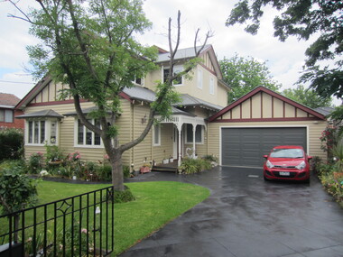
 Surrey Hills Historical Society Collection
Photograph - 1A St Georges Avenue, Mont Albert, The Street Where You Live Project
Photos documenting this address as part of a photographic series undertaken by volunteer photographers during 2013 and 2014 for The Street Where You Live Project. This was organised through the Surrey Hills Neighbourhood Centre and covered the postcode 3127 in the cities of Boroondara and Whitehorse.These photos provide a snapshot of real estate in the suburbs of Mont Albert and Surrey Hills during a period of rapid change with many properties on large blocks demolished to create higher density residential development or renewal of single dwellings. At particular risk were properties not covered by heritage overlays, in particular interwar housing and post 1950's housing. -
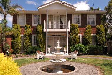
 Surrey Hills Historical Society Collection
Photograph - 3 St Georges Avenue, Mont Albert, The Street Where You Live Project
Photos documenting this address as part of a photographic series undertaken by volunteer photographers during 2013 and 2014 for The Street Where You Live Project. This was organised through the Surrey Hills Neighbourhood Centre and covered the postcode 3127 in the cities of Boroondara and Whitehorse.These photos provide a snapshot of real estate in the suburbs of Mont Albert and Surrey Hills during a period of rapid change with many properties on large blocks demolished to create higher density residential development or renewal of single dwellings. At particular risk were properties not covered by heritage overlays, in particular interwar housing and post 1950's housing. -
 Surrey Hills Historical Society Collection
Photograph - 4 St Georges Avenue, Mont Albert, The Street Where You Live Project
Photos documenting this address as part of a photographic series undertaken by volunteer photographers during 2013 and 2014 for The Street Where You Live Project. This was organised through the Surrey Hills Neighbourhood Centre and covered the postcode 3127 in the cities of Boroondara and Whitehorse.These photos provide a snapshot of real estate in the suburbs of Mont Albert and Surrey Hills during a period of rapid change with many properties on large blocks demolished to create higher density residential development or renewal of single dwellings. At particular risk were properties not covered by heritage overlays, in particular interwar housing and post 1950's housing.