Showing 1770 items
matching binder
-
 Eltham District Historical Society Inc
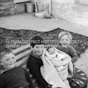
Negative - Photograph, J.A. McDonald, Unidentified children, Sep. 1959
Believed to be four children all of the same family, most probably those of an Eltham Shire Council employee who worked for the Engineering department (see image 05584-8)Record of various Shire of Eltham infrastructure works undertaken during the period of 1952-1962 involving bridge and road reconstruction projects, sometimes with Eltham Shire Council Project Reference numbers quoted. It was during this period that a number of significant improvements were made to roads and new bridges constructed within the shire that remain in place as of present day (2022). In many situations, the photos provide a tangible visible record of infrastructure that existed throughout the early days of the Shire. The album was put together by or under the direction of the Shire Engineer, J.A. McDonald.shire of eltham, 1959-09, children -
 Eltham District Historical Society Inc
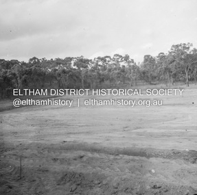
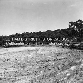
Negative - Photograph, J.A. McDonald, Reconstruction works, Research Oval, Jan. 1961
Looking north Early January 1961Record of various Shire of Eltham infrastructure works undertaken during the period of 1952-1962 involving bridge and road reconstruction projects, sometimes with Eltham Shire Council Project Reference numbers quoted. It was during this period that a number of significant improvements were made to roads and new bridges constructed within the shire that remain in place as of present day (2022). In many situations, the photos provide a tangible visible record of infrastructure that existed throughout the early days of the Shire. The album was put together by or under the direction of the Shire Engineer, J.A. McDonald.shire of eltham, 1961-01, infrastructure, reconstruction works, research (vic.), research oval -
 Eltham District Historical Society Inc
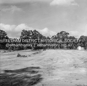
Negative - Photograph, J.A. McDonald, Reconstruction works, Research Oval, Jan. 1961
At commencement, looking east Early January 1961Record of various Shire of Eltham infrastructure works undertaken during the period of 1952-1962 involving bridge and road reconstruction projects, sometimes with Eltham Shire Council Project Reference numbers quoted. It was during this period that a number of significant improvements were made to roads and new bridges constructed within the shire that remain in place as of present day (2022). In many situations, the photos provide a tangible visible record of infrastructure that existed throughout the early days of the Shire. The album was put together by or under the direction of the Shire Engineer, J.A. McDonald.shire of eltham, 1961-01, infrastructure, reconstruction works, research (vic.), research oval -
 Eltham District Historical Society Inc
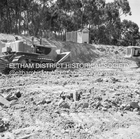
Negative - Photograph, J.A. McDonald, Reconstruction works, Research Oval, Jan. 1961
Looking southeast Late January 1961Record of various Shire of Eltham infrastructure works undertaken during the period of 1952-1962 involving bridge and road reconstruction projects, sometimes with Eltham Shire Council Project Reference numbers quoted. It was during this period that a number of significant improvements were made to roads and new bridges constructed within the shire that remain in place as of present day (2022). In many situations, the photos provide a tangible visible record of infrastructure that existed throughout the early days of the Shire. The album was put together by or under the direction of the Shire Engineer, J.A. McDonald.shire of eltham, 1961-01, infrastructure, reconstruction works, research (vic.), research oval -
 Eltham District Historical Society Inc
Negative - Photograph, J.A. McDonald, Reconstruction works, Research Oval, Jan. 1961
Looking north at end of reconstruction Late January 1961Record of various Shire of Eltham infrastructure works undertaken during the period of 1952-1962 involving bridge and road reconstruction projects, sometimes with Eltham Shire Council Project Reference numbers quoted. It was during this period that a number of significant improvements were made to roads and new bridges constructed within the shire that remain in place as of present day (2022). In many situations, the photos provide a tangible visible record of infrastructure that existed throughout the early days of the Shire. The album was put together by or under the direction of the Shire Engineer, J.A. McDonald.shire of eltham, 1961-01, infrastructure, reconstruction works, research (vic.), research oval -
 Eltham District Historical Society Inc
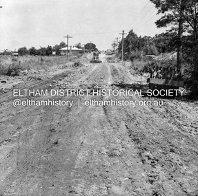
Negative - Photograph, J.A. McDonald, Eltham, Susan Street, Jan. 1961
January 1961 Looking towards Dalton Street (present-day Withers Way) Just south of Brougham Street. To the immediate left is the present-day car park for the Elham Leisure Centre. The house on the left is immediately opposite Cromwell street and adjacent to the southwest corner of the Leisure Centre buiding (where the Williams house sits hidden from view)Record of various Shire of Eltham infrastructure works undertaken during the period of 1952-1962 involving bridge and road reconstruction projects, sometimes with Eltham Shire Council Project Reference numbers quoted. It was during this period that a number of significant improvements were made to roads and new bridges constructed within the shire that remain in place as of present day (2022). In many situations, the photos provide a tangible visible record of infrastructure that existed throughout the early days of the Shire. The album was put together by or under the direction of the Shire Engineer, J.A. McDonald.shire of eltham, infrastructure, 1961-01, cromwell street, eltham leisure centre, road construction, susan street -
 Eltham District Historical Society Inc
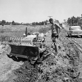
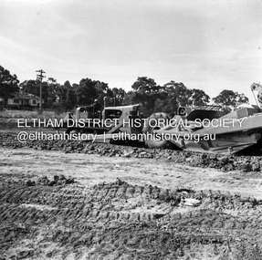
Negative - Photograph, J.A. McDonald, Eltham, Susan Street, Jan. 1961
January 1961 Looking south Brown excavating Brougham to Dalton (present-day Withers Way) F. Woods Consolidating showing soft fill over culvert after 9 months Just south of Brougham Street. To the immediate left is the present-day car park for the Elham Leisure Centre. The house on the left is immediately opposite Cromwell street and adjacent to the southwest corner of the Leisure Centre buiding (where the Williams house sits hidden from view)Record of various Shire of Eltham infrastructure works undertaken during the period of 1952-1962 involving bridge and road reconstruction projects, sometimes with Eltham Shire Council Project Reference numbers quoted. It was during this period that a number of significant improvements were made to roads and new bridges constructed within the shire that remain in place as of present day (2022). In many situations, the photos provide a tangible visible record of infrastructure that existed throughout the early days of the Shire. The album was put together by or under the direction of the Shire Engineer, J.A. McDonald.shire of eltham, infrastructure, 1961-01, cromwell street, eltham leisure centre, road construction, susan street -
 Eltham District Historical Society Inc
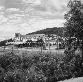
Negative - Photograph, J.A. McDonald, Unidentified quarry, Jan. 1961
Record of various Shire of Eltham infrastructure works undertaken during the period of 1952-1962 involving bridge and road reconstruction projects, sometimes with Eltham Shire Council Project Reference numbers quoted. It was during this period that a number of significant improvements were made to roads and new bridges constructed within the shire that remain in place as of present day (2022). In many situations, the photos provide a tangible visible record of infrastructure that existed throughout the early days of the Shire. The album was put together by or under the direction of the Shire Engineer, J.A. McDonald.1961-01, quarry -
 Eltham District Historical Society Inc
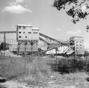
Negative - Photograph, J.A. McDonald, Unidentified quarry, Jan. 1961
Record of various Shire of Eltham infrastructure works undertaken during the period of 1952-1962 involving bridge and road reconstruction projects, sometimes with Eltham Shire Council Project Reference numbers quoted. It was during this period that a number of significant improvements were made to roads and new bridges constructed within the shire that remain in place as of present day (2022). In many situations, the photos provide a tangible visible record of infrastructure that existed throughout the early days of the Shire. The album was put together by or under the direction of the Shire Engineer, J.A. McDonald.1961-01, quarry -
 Eltham District Historical Society Inc
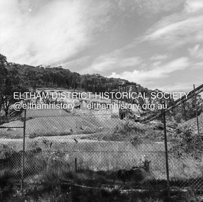
Negative - Photograph, J.A. McDonald, Unidentified quarry, Jan. 1961
Record of various Shire of Eltham infrastructure works undertaken during the period of 1952-1962 involving bridge and road reconstruction projects, sometimes with Eltham Shire Council Project Reference numbers quoted. It was during this period that a number of significant improvements were made to roads and new bridges constructed within the shire that remain in place as of present day (2022). In many situations, the photos provide a tangible visible record of infrastructure that existed throughout the early days of the Shire. The album was put together by or under the direction of the Shire Engineer, J.A. McDonald.1961-01, quarry -
 Eltham District Historical Society Inc
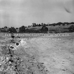
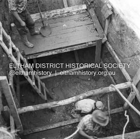
Negative - Photograph, J.A. McDonald, Reconstruction works, Lower Plenty Oval, Jan. 1961
3 February 1961 Looking towards Rattray RoadRecord of various Shire of Eltham infrastructure works undertaken during the period of 1952-1962 involving bridge and road reconstruction projects, sometimes with Eltham Shire Council Project Reference numbers quoted. It was during this period that a number of significant improvements were made to roads and new bridges constructed within the shire that remain in place as of present day (2022). In many situations, the photos provide a tangible visible record of infrastructure that existed throughout the early days of the Shire. The album was put together by or under the direction of the Shire Engineer, J.A. McDonald.1961-01, infrastructure, lower plenty oval, reconstruction works, shire of eltham -
 Eltham District Historical Society Inc
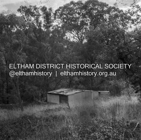
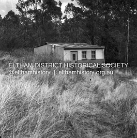
Negative - Photograph, J.A. McDonald, Road Reserve Housing, Mar. 1961
Shack built on road reserve without permit Most probably up on Simms Road, Kinglake Other areas where illegal shacks were built wer at the junction of Flat Rock Road and Cherry Tree Road, Hurstbridge. At times, Building Surveyor George E Newton would have to attend to these shacks for inspection and issue demolition ordersRecord of various Shire of Eltham infrastructure works undertaken during the period of 1952-1962 involving bridge and road reconstruction projects, sometimes with Eltham Shire Council Project Reference numbers quoted. It was during this period that a number of significant improvements were made to roads and new bridges constructed within the shire that remain in place as of present day (2022). In many situations, the photos provide a tangible visible record of infrastructure that existed throughout the early days of the Shire. The album was put together by or under the direction of the Shire Engineer, J.A. McDonald.infrastructure, shire of eltham, 1961-03, building surveyor, cherry tree road, flat rock road, george e. newton, houses, hurstbridge, kinglake, road reserve, road reserve housing, scan - 120 format 6x6 negative, shack, simms road -
 Eltham District Historical Society Inc
Negative - Photograph, J.A. McDonald, Road Reserve Housing, Mar. 1961
Shack built on road reserve without permit Most probably up on Simms Road, Kinglake Other areas where illegal shacks were built were at the junction of Flat Rock Road and Cherry Tree Road, Hurstbridge. At times, Building Surveyor George E Newton would have to attend to these shacks for inspection and issue demolition ordersRecord of various Shire of Eltham infrastructure works undertaken during the period of 1952-1962 involving bridge and road reconstruction projects, sometimes with Eltham Shire Council Project Reference numbers quoted. It was during this period that a number of significant improvements were made to roads and new bridges constructed within the shire that remain in place as of present day (2022). In many situations, the photos provide a tangible visible record of infrastructure that existed throughout the early days of the Shire. The album was put together by or under the direction of the Shire Engineer, J.A. McDonald.infrastructure, shire of eltham, 1961-03, building surveyor, cherry tree road, flat rock road, george e. newton, houses, hurstbridge, kinglake, road reserve, road reserve housing, scan - 120 format 6x6 negative, shack, simms road -
 Eltham District Historical Society Inc
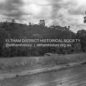
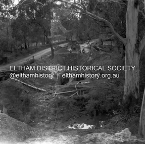
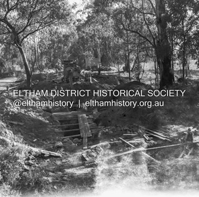
Negative - Photograph, J.A. McDonald, Henley Road at Watsons Creek, Mar. 1961
Old bridge over Watsons Creek 22 March 1961 Cr. Pelling and Contractor WolfRecord of various Shire of Eltham infrastructure works undertaken during the period of 1952-1962 involving bridge and road reconstruction projects, sometimes with Eltham Shire Council Project Reference numbers quoted. It was during this period that a number of significant improvements were made to roads and new bridges constructed within the shire that remain in place as of present day (2022). In many situations, the photos provide a tangible visible record of infrastructure that existed throughout the early days of the Shire. The album was put together by or under the direction of the Shire Engineer, J.A. McDonald.infrastructure, shire of eltham, 1961-03, bend of islands, cr. charis pelling, henley road, henley road bridge, kangaroo ground, oxley bridge, watsons creek, w.e. wolf, bridge construction, road construction -
 Eltham District Historical Society Inc
Negative - Photograph, J.A. McDonald, Henley Road at Watsons Creek, Mar. 1961
Henley Road at Watsons Creek Looking easterly along new alignment, 22 March 1961 C. Browns Excavator Contractor Wolf Cr PellingRecord of various Shire of Eltham infrastructure works undertaken during the period of 1952-1962 involving bridge and road reconstruction projects, sometimes with Eltham Shire Council Project Reference numbers quoted. It was during this period that a number of significant improvements were made to roads and new bridges constructed within the shire that remain in place as of present day (2022). In many situations, the photos provide a tangible visible record of infrastructure that existed throughout the early days of the Shire. The album was put together by or under the direction of the Shire Engineer, J.A. McDonald.infrastructure, shire of eltham, 1961-03, bend of islands, cr. charis pelling, henley road, henley road bridge, kangaroo ground, oxley bridge, watsons creek, w.e. wolf, bridge construction, road construction -
 Eltham District Historical Society Inc
Negative - Photograph, J.A. McDonald, Eltham, Haldane Road, Mar. 1961
Dr Donald Thomson's gate and entrance to his property 'Worlingworth' after flooding in March 1961 "Worlingworth", Eltham, was the home of noted anthropologist the late Professor Donald Thomson and his wife Dorita. The entrance gate on Banoon Road is located at the bottom of the hill opposite Haldane Road. The flooding issues were regularly reported to Council following heavy rain. Google Street View Feb 2014 https://goo.gl/maps/SGjsJAAEdjQXgo5V9Record of various Shire of Eltham infrastructure works undertaken during the period of 1952-1962 involving bridge and road reconstruction projects, sometimes with Eltham Shire Council Project Reference numbers quoted. It was during this period that a number of significant improvements were made to roads and new bridges constructed within the shire that remain in place as of present day (2022). In many situations, the photos provide a tangible visible record of infrastructure that existed throughout the early days of the Shire. The album was put together by or under the direction of the Shire Engineer, J.A. McDonald.infrastructure, shire of eltham, 1961-03, flood damage, haldane road, prof donald thomson, worlingworth -
 Eltham District Historical Society Inc
Negative - Photograph, J.A. McDonald, Para Road, Mar. 1961
Wash out 51 Para Road after heavy rain 28 March 1961Record of various Shire of Eltham infrastructure works undertaken during the period of 1952-1962 involving bridge and road reconstruction projects, sometimes with Eltham Shire Council Project Reference numbers quoted. It was during this period that a number of significant improvements were made to roads and new bridges constructed within the shire that remain in place as of present day (2022). In many situations, the photos provide a tangible visible record of infrastructure that existed throughout the early days of the Shire. The album was put together by or under the direction of the Shire Engineer, J.A. McDonald.infrastructure, shire of eltham, 1961-03, flood damage, para road -
 Eltham District Historical Society Inc
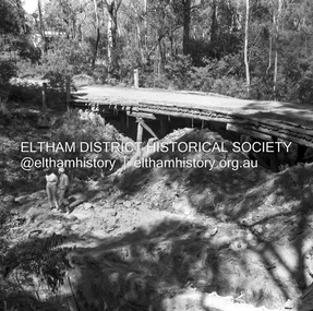
Negative - Photograph, J.A. McDonald, Henley Road at Watsons Creek, Apr. 1961
Henley Road at Watsons Creek looking easterly along centreline from west abutment Early April 1961Record of various Shire of Eltham infrastructure works undertaken during the period of 1952-1962 involving bridge and road reconstruction projects, sometimes with Eltham Shire Council Project Reference numbers quoted. It was during this period that a number of significant improvements were made to roads and new bridges constructed within the shire that remain in place as of present day (2022). In many situations, the photos provide a tangible visible record of infrastructure that existed throughout the early days of the Shire. The album was put together by or under the direction of the Shire Engineer, J.A. McDonald.infrastructure, shire of eltham, bend of islands, cr. charis pelling, henley road, henley road bridge, kangaroo ground, oxley bridge, watsons creek, w.e. wolf, bridge construction, road construction, 1961-04 -
 Eltham District Historical Society Inc
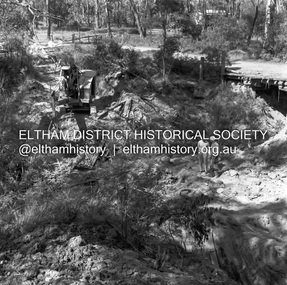
Negative - Photograph, J.A. McDonald, Henley Road at Watsons Creek, Apr. 1961
Henley Road at Watsons Creek showing excavation at western pier Rock at contract level, slight underground flow Early April 1961Record of various Shire of Eltham infrastructure works undertaken during the period of 1952-1962 involving bridge and road reconstruction projects, sometimes with Eltham Shire Council Project Reference numbers quoted. It was during this period that a number of significant improvements were made to roads and new bridges constructed within the shire that remain in place as of present day (2022). In many situations, the photos provide a tangible visible record of infrastructure that existed throughout the early days of the Shire. The album was put together by or under the direction of the Shire Engineer, J.A. McDonald.infrastructure, shire of eltham, bend of islands, cr. charis pelling, henley road, henley road bridge, kangaroo ground, oxley bridge, watsons creek, w.e. wolf, bridge construction, road construction, 1961-04 -
 Eltham District Historical Society Inc
Negative - Photograph, J.A. McDonald, Henley Road at Watsons Creek, Apr. 1961
Henley Road at Watsons Creek looking westerly along centreline from east abutment Early April 1961Record of various Shire of Eltham infrastructure works undertaken during the period of 1952-1962 involving bridge and road reconstruction projects, sometimes with Eltham Shire Council Project Reference numbers quoted. It was during this period that a number of significant improvements were made to roads and new bridges constructed within the shire that remain in place as of present day (2022). In many situations, the photos provide a tangible visible record of infrastructure that existed throughout the early days of the Shire. The album was put together by or under the direction of the Shire Engineer, J.A. McDonald.infrastructure, shire of eltham, bend of islands, cr. charis pelling, henley road, henley road bridge, kangaroo ground, oxley bridge, watsons creek, w.e. wolf, bridge construction, road construction, 1961-04 -
 Eltham District Historical Society Inc
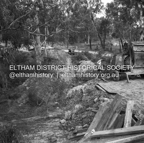
Negative - Photograph, J.A. McDonald, Henley Road at Watsons Creek, Apr. 1961
Henley Road at Watsons Creek looking westerly showing west abutment excavation Mid April 1961Record of various Shire of Eltham infrastructure works undertaken during the period of 1952-1962 involving bridge and road reconstruction projects, sometimes with Eltham Shire Council Project Reference numbers quoted. It was during this period that a number of significant improvements were made to roads and new bridges constructed within the shire that remain in place as of present day (2022). In many situations, the photos provide a tangible visible record of infrastructure that existed throughout the early days of the Shire. The album was put together by or under the direction of the Shire Engineer, J.A. McDonald.infrastructure, shire of eltham, bend of islands, cr. charis pelling, henley road, henley road bridge, kangaroo ground, oxley bridge, watsons creek, w.e. wolf, bridge construction, road construction, 1961-04 -
 Eltham District Historical Society Inc
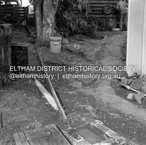
Negative - Photograph, J.A. McDonald, Old house, Susan Street, Eltham, c. 1962
Williams house, Susan StreetRecord of various Shire of Eltham infrastructure works undertaken during the period of 1952-1962 involving bridge and road reconstruction projects, sometimes with Eltham Shire Council Project Reference numbers quoted. It was during this period that a number of significant improvements were made to roads and new bridges constructed within the shire that remain in place as of present day (2022). In many situations, the photos provide a tangible visible record of infrastructure that existed throughout the early days of the Shire. The album was put together by or under the direction of the Shire Engineer, J.A. McDonald.eltham, houses, susan street, williams house -
 Eltham District Historical Society Inc
Negative - Photograph, J.A. McDonald, Old house, Susan Street, Eltham, c. 1962
Williams house, Susan StreetRecord of various Shire of Eltham infrastructure works undertaken during the period of 1952-1962 involving bridge and road reconstruction projects, sometimes with Eltham Shire Council Project Reference numbers quoted. It was during this period that a number of significant improvements were made to roads and new bridges constructed within the shire that remain in place as of present day (2022). In many situations, the photos provide a tangible visible record of infrastructure that existed throughout the early days of the Shire. The album was put together by or under the direction of the Shire Engineer, J.A. McDonald.eltham, houses, susan street, williams house -
 Ballarat Tramway Museum
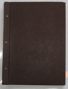
Album - Photo Album, Wal Jack, 1950's
These notes are based on a report prepared for the Board re the donation of materials collected by Wal Jack and donated to the BTM in 2011. The following notes are general across the collection unless written for a specific Ballarat item. Has proven association with Wal Jack and tramway developments within Australasia until 1964 and given their extent particular significance. Features Sydney TramsDark brown binder cloth covered folder, 3 brass screw binders brown paper inside covers holding some 50 manila cover foolscap size sheets of card on which photos have been mounted using photo corners so various types, captions in black ink. Folder supplied Norman Bros Melbourne. Has photos of various locations and lines within Sydney including some works trams. trams, tramways, sydney, tramcars, wal jack -
 Clunes Museum
Manual - FARM MACHINERY MANUAL, Between 1923-1929
.1 Sunshine Reaper & Binder Instructions for assembling and starting .2 Sunshine Stripper Harvester 6ft. Instructions for starting and working .3 Duplicate Parts for Sunshine Reaper & Binder with 6 and 8ft cut .4 Duplicate Parts for 3 furrow Sunrise Stump Jump Disc Plough .5 Duplicate Parts for Sunshine Steel Frame Harvesters Types A-H .6 Duplicate Parts for Sunrise Stump Jump Mouldboard Ploughs 3,4,5,6 furrows .5 Machine brought through H. Cunninghamsunshine harvester, sunshine reapers & binders, duplicate parts book, stump jump plough, stump jump mouldboard plough, steel frame harvester, operating manual -
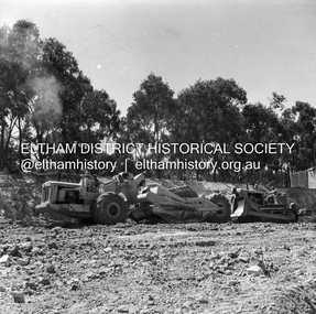
 Eltham District Historical Society Inc
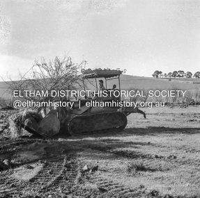
Negative - Photograph, J.A. McDonald, Kangaroo Ground-Queenstown Road, Aug. 1960
(Kangaroo Ground-St Andrews Road) “Rymers” Corner – shifting Hawthorn hedges on Tompkins property Council’s Drott 6 Woods Drott 9 August 1960 Showing hedge in rear already transported EDHS_05569-55 (EDHS_05577-3/4) and EDHS_05569-56 (EDHS_05577-5/6) - Hawthorn Hedges, Kangaroo Ground 50-50 ELTHAM, CUT THE HEDGES! While all of us are talking about the road toll, Eltham Council must have been in long recess. Around Kangaroo Ground are farmers’ hawthorn hedges shrouding dangerous corners on busy roads. If the council does not insist on their removal for a distance clear enough for safe driving, then it must be held culpable for the accidents that are bound to happen. – WAKE UP (Melbourne) ELTHAM, CUT THE HEDGES! 50-50 (1960, 6 January), The Sun (News clipping held in SEA_74-1_007) ‘BAD HEDGES’ WILL GO “We know there are some bad hedges on corners in the Kangaroo Ground area, but roadworks this year will eliminate them,” the Eltham Shire secretary, Mr Maxwell B. Watson, said yesterday. A reader in 50-50 yesterday complained of farmers’ hawthorn hedges obscuring drivers’ views at bad corners on busy roads in the Kangaroo Ground district. Mr Watson said the roadworks were deviations to remove the sharp turns, and the road would cut back into paddocks. The hedges would go at the same time. Meanwhile, the shire had power to require owners to cut back hedges, and this would be done if specific instances were reported and found justifiable. ‘BAD HEDGES’ WILL GO (1960, January 7), The Sun (News clipping held in SEA_74-1_007)Record of various Shire of Eltham infrastructure works undertaken during the period of 1952-1962 involving bridge and road reconstruction projects, sometimes with Eltham Shire Council Project Reference numbers quoted. It was during this period that a number of significant improvements were made to roads and new bridges constructed within the shire that remain in place as of present day (2022). In many situations, the photos provide a tangible visible record of infrastructure that existed throughout the early days of the Shire. The album was put together by or under the direction of the Shire Engineer, J.A. McDonald.infrastructure, shire of eltham, 1960-08, garden hill, kangaroo ground, kangaroo ground-queenstown road, kangaroo ground-st andrews road, rymers corner, bulldozer, drott