Showing 1327 items matching "car park"
-
 Eltham District Historical Society Inc
Photograph, Liz Pidgeon, Heritage Excursion; The 1901 Eltham Railway Walk, 3 May 2014, 3 May 2014
... Station car park (east/Main Road side) (Melway Ref. 21 J5).... Station car park (east/Main Road side) (Melway Ref. 21 J5 ...Newsletter No. 216, May 2014 May Excursion – The 1901 Eltham Railway Walk The railway from Heidelberg to Eltham was opened in 1902. Over the previous year railway construction cut a curving swathe through Josiah Holloway’s 1851 Little Eltham subdivision. The survey plans for the railway show the owners and occupiers of land within Little Eltham affected by the railway alignment and for some distance each side. The plans show houses and other buildings but development at that time was rather sparse. Copies of these plans from the State Library of Victoria collection have been provided to the Society by Alan Sheehan. For our walk on 3rd May we intend to follow the railway from the Eltham Station to Ryans Road, which was the boundary of the adjoining Montmorency Farm. The return will be by way of nearby streets. Along the way we will discuss the details shown on the railway plans as well as more recent railway documents and photographs. At the conclusion and if time permits we can inspect the historical display at the Eltham Station. The walk is about 3 km in length and will take about 2.5 hours. It will start at 2 pm at the Eltham Railway Station car park (east/Main Road side) (Melway Ref. 21 J5).Born Digitalheritage excursion, activities, eltham district historical society, eltham railway station, eltham library, trestle bridge -
 Eltham District Historical Society Inc
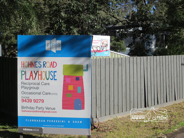
Photograph, Liz Pidgeon, Hohnes Road Playhouse, 1 July 2017
... hours. It will start at 2pm at the Main Road car park... hours. It will start at 2pm at the Main Road car park ...Photo taken as part of an EDHS Heritage Excursion - Saturday 1st July - Eltham Lower Park - Walk and Talk. "Eltham Lower Park has played an important part in the history of our area since the early days of European settlement when it was used by local residents as an informal racecourse. Prior to that its location at the junction of the Diamond Creek and the Yarra River made it an important meeting place for the Wurundjeri people. The park combines formal elements and sporting facilities with remnant bushland that is of environmental significance. It is home to sporting and horse riding clubs, popular play spaces and the Diamond Valley Miniature Railway, which attracts large numbers of visitors.The park will be the venue for our July excursion which will comprise a walk of about 3.5 km around the park and adjacent areas. Along the way we will discuss the history and natural history of the area. The path along the creek and the river provides a pleasant and scenic walk.This walk on Saturday 1st July is about 3.5 km in length and will take 2 to 2.5 hours. It will start at 2pm at the Main Road car park at the front of the park. (Melway ref 21 H 10)". Newsletter No., 234, June 2017 Born Digitalheritage excursion, activities, eltham district historical society, eltham lower park, sign, hohnes road playhouse -
 Linton and District Historical Society Inc
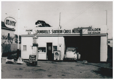
Photograph, Dumbrell's Southern Cross Motors, 52 Sussex Street, Linton
... the photograph was taken is unknown. The car that is parked.... The date the photograph was taken is unknown. The car ...This garage was on the site of the Ball family's blacksmith's workshop. In 2017 parts of the building are still on the site, although in a very dilapidated condition.Photograph copied from original of a petrol station/mechanic's workshop. At the time the photograph was taken the workshop was owned by John and Alice (Jill) Dumbrell. The date the photograph was taken is unknown. The car that is parked in the workshop was owned by Ernie Page, an employee of the Bank of New South Wales in Linton.john dumbrell, alice (jill) dumbrell, dumbrell's southern cross motors linton, holden dealership linton, atlantic petrol, buildings, petrol stations, mechanics, dark family -
 Melbourne Tram Museum
Negative - Set of 2, Ellis Collection, c1940
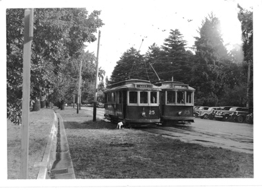
... on a grip car at Edwards Park Reservoir... htd3607 for a photo of the family on a grip car at Edwards Park ...Set of two Negatives of Inspector W. H. Ellis and his son? at a home in Melbourne. Name from the list of negatives provided. Not known whether this is the same person as other photographs or a relative. See image htd3607 for a photo of the family on a grip car at Edwards Park Reservoirtrams, tramways, inspectors, personnel -
 Melbourne Tram Museum
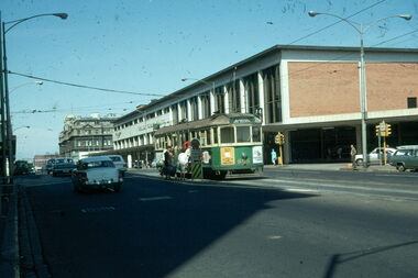
Slide - Set of 4, Vic Solomons, Jun. 1970
... - As above, tram approaching the stop with the Spencer St station car... - As above, tram approaching the stop with the Spencer St station car ...Slide - set of 4 - 35mm - Kodachrome cardboard mounts. .1 - Tram 808 at the Spencer St stop at the corner of Bourke St with Spencer St Station in the background. Note the route and destination - at the time when North Balwyn and Burwood Routes were combined on Sundays am and evening - and passengers changed at Hawthorn Bridge. Route 74. Has a Fosters Lager advertisement. .2 - As above, tram approaching the stop with the Spencer St station car park in the background. .3 - tram 1005 leaving the Bourke St terminus, taken after .4 .4 - tram 1005 at the Bourke St terminus with tram 838 crossing in the background, has the Station building, Carlyon's Hotel and the Tramways Building. Note the Bundy clock, tram stop signage and safety zone. Route 96. The grey box by the Bundy Clock is thought to be a correspondence box for the satchels that were transported between the depots and head office. Photographed by Vic Solomons June 1970 (based on date stamped on slide)trams, tramways, bourke st, spencer st, railways, stations, route 74, north balwyn, burwood, route 96, letters, mails, tram 808, tram 1005, tram 838 -
 City of Kingston
Photograph - Black and white, c. 1970
... of the image there are trees behind a parked car which is adjacent... is sealed. At the top of the image there are trees behind a parked ...This photograph depicts the steel tramway (or tram plate) along Centre Dandenong Road, Cheltenham near the Moorabbin Airport entrance in the 1970's. These tramways played an important role in transportation along Moorabbin's major roads. Heavily laden carts could travel smoothly and safely along the steel plates when the road surfaces were often rutted and hazardous. This surviving section was later moved for road improvements. The area now known as the City of Kingston was a market garden region and the round trip to market could take as long as eight hours on poorly maintained roads. The installation of the steel tramway transformed the arduous journey faced by market gardeners in transporting their produce to market. As there was only a single tramway, the carts often travelled in convoy, enabling drivers to leave piloting to the first cart and having a rest. The rails did not speed the journey to the city, but it smoothed progress immeasurably. Black and white photograph of steel tram plates on Centre Dandenong Road, Cheltenham. The road is sealed. At the top of the image there are trees behind a parked car which is adjacent to a white shelter. There is a large sign stating MOORABBIN AIRPORT above an arrow pointing to the right in the top centre of the image. Handwritten in pencil: A 28 / [indecipherable] 3 / [indecipherable] Handwritten in red ink: A28 / 70%market gardening, infrastructure, transport, steel tramway, industry, moorabbin -
 Melbourne Tram Museum
Photograph - Black & White Photograph/s, mid 1970's
... Black and white photograph of TMSV Horse tram (Royal Park... photograph of TMSV Horse tram (Royal Park car 256) operations ...Black and white photograph of TMSV Horse tram (Royal Park car 256) operations at Bylands during a Vintage Car rally, mid 1970's. No details on rear. See Reg Item 1601 for a TMSV pamphlet on which the photo was used. May provide photographer details.trams, tramways, tmsv, bylands, horse trams, tram 256 -
 Ringwood and District Historical Society
Photographs, Suda and Khassa Ave Ringwood, Before and after Ringwood Bypass Construction 1993
... car park development. Shrub on left is in the bowling club. ... the grey wall along Miles St to support the new car park ...B&W photograph taken by Ringwood Historical Research Group. Also added extract from Melways showing the roads before the Bypass (1987) showing the planned Bypass cutting these two roads, and Melways (2018) showing new alignment with Bypass11063A: 17.1.93 Suda Ave Still intact towards Maroondah Hwy. Taken near Khassa Pde 11063B: 17.1.93 Suda Ave. House gone. Near Khassa Pde 11063C: 17.1.93 Ringwood Bypass from cnr Khassa Pde and Suda Ave towards Mt Dandenong Rd 11063D: 17.2.93 Suda Ave. House gone. 11063E: 21.2.93 cnr Khassa Pde and Suda Ave. Direction of next cut for the Ringwood Bypass. Trees to go. 11063F: 21.2.93 Connection from ??? St to North end of Suda Ave 11063G: 22.2.93 Adelaide St to right (closed). Mile Ave in front and turning left. Note the grey wall along Miles St to support the new car park development. Shrub on left is in the bowling club. -
 Whitehorse Historical Society Inc.
Photograph, Corner Doncaster East & Mitcham Roads, 2000
... pine trees and parked sedan cars backing on to Mitcham Private... and Mitcham Road, looking North. Four tall pine trees and parked sedan ...Produced as one of a series of 24 prints commissioned by Nunawading & District Historical Society -|Theme: Intersections of Mitcham and Nunawading 2000/2001.|See also Series by P. Simmenauer on the same theme.Black and white photograph - print and negative of Corner of Doncaster East Road and Mitcham Road, looking North. Four tall pine trees and parked sedan cars backing on to Mitcham Private Hospital.doncaster east road, mitcham, mitcham road, mitcham & district private hospital -
 Lakes Entrance Historical Society
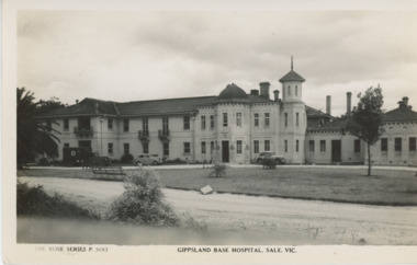
Postcard, Rose Series, The Gippsland Base Hospital Sale Victoria, 1930 c
... building. Two cars and an ambulance parked outside main building... in front of a ground floor building. Two cars and an ambulance ...Black and white postcard of Gippsland Base Hospital showing extensive double storeyed building in front of a ground floor building. Two cars and an ambulance parked outside main building Sale Victoriahospital, township -
 Peterborough History Group
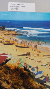
Photograph - Surf Carnival, Newfield Bay, Jocelyn Burt
... over the sand dunes. Spectators cars were parked in the area... the sand dunes. Spectators cars were parked in the area which ...Unusual choice of location by Port Campbell Surf club due to Port Campbell beach being too small. The Surf Carnival was held at Newfield Bay (possibly for two years running). Eyewitness accounts advise that one year the surf was so rough that the event was abandoned. This photograph appears to show calmer sea. In order to get the surf boats onto the beach a track was bulldozed over the sand dunes. Spectators cars were parked in the area which is now the airstrip, on the corner of the Port Campbell Peterborough Road and the Timboon Peterborough road.Town eventOriginal photograph of the surf carnival, taken from the west looking towards the east, with the Crown of thorns visible in the background. Surf boats are on the beach and umbrellas are visible. Occurred in the early 1970's.Written on the back is Jocelyn Burt, who is a photographer.newfield bay, surf lifesaving carnival, peterborough, jocelyn burt, crown of thorns rock formation -
 Eltham District Historical Society Inc
Photograph, Liz Pidgeon, Heritage Excursion; Eltham Lower Park Walk and Talk, 1 July 2017, 1 July 2017
... Railway, which attracts large numbers of visitors. The park... Railway, which attracts large numbers of visitors. The park ...Sign: Nillumbik Shire Council Pony Club area dogs must be leashed horses must not be ridden on asphalt pathways Newsletter No., 234, June 2017 Heritage Excursion - Saturday 1st July - Eltham Lower Park - Walk and Talk Eltham Lower Park has played an important part in the history of our area since the early days of European settlement when it was used by local residents as an informal racecourse. Prior to that its location at the junction of the Diamond Creek and the Yarra River made it an important meeting place for the Wurundjeri people. The park combines formal elements and sporting facilities with remnant bushland that is of environmental significance. It is home to sporting and horse riding clubs, popular play spaces and the Diamond Valley Miniature Railway, which attracts large numbers of visitors. The park will be the venue for our July excursion which will comprise a walk of about 3.5 km around the park and adjacent areas. Along the way we will discuss the history and natural history of the area. The path along the creek and the river provides a pleasant and scenic walk. This walk on Saturday 1st July is about 3.5 km in length and will take 2 to 2.5 hours. It will start at 2pm at the Main Road car park at the front of the park. (Melway ref 21 H 10). Born Digitalelection day, heritage excursion, activities, eltham district historical society, eltham lower park, sign, eltham pony club -
 Eltham District Historical Society Inc
Photograph, Liz Pidgeon, Heritage Excursion; Eltham Lower Park Walk and Talk, 1 July 2017, 1 July 2017
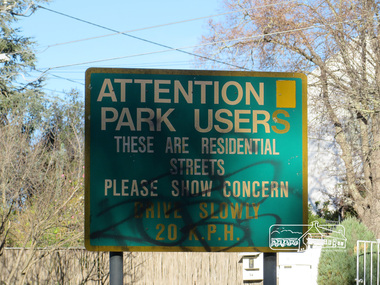
... Railway, which attracts large numbers of visitors. The park... Railway, which attracts large numbers of visitors. The park ...Street signage: Attention park users these are residential streets please show concern drive slowly 20 m.p.h with graffiti Newsletter No., 234, June 2017 Heritage Excursion - Saturday 1st July - Eltham Lower Park - Walk and Talk Eltham Lower Park has played an important part in the history of our area since the early days of European settlement when it was used by local residents as an informal racecourse. Prior to that its location at the junction of the Diamond Creek and the Yarra River made it an important meeting place for the Wurundjeri people. The park combines formal elements and sporting facilities with remnant bushland that is of environmental significance. It is home to sporting and horse riding clubs, popular play spaces and the Diamond Valley Miniature Railway, which attracts large numbers of visitors. The park will be the venue for our July excursion which will comprise a walk of about 3.5 km around the park and adjacent areas. Along the way we will discuss the history and natural history of the area. The path along the creek and the river provides a pleasant and scenic walk. This walk on Saturday 1st July is about 3.5 km in length and will take 2 to 2.5 hours. It will start at 2pm at the Main Road car park at the front of the park. (Melway ref 21 H 10). Born Digitalheritage excursion, activities, eltham district historical society, eltham lower park, sign, grafitti -
 Eltham District Historical Society Inc
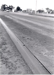
Photograph, Liz Pidgeon, Heritage Excursion; The 1901 Eltham Railway Walk, 3 May 2014, 3 May 2014
... Station car park (east/Main Road side) (Melway Ref. 21 J5).... Station car park (east/Main Road side) (Melway Ref. 21 J5 ...Football match at Eltham Central Park between Eltham and Heidelberg Newsletter No. 216, May 2014 May Excursion – The 1901 Eltham Railway Walk The railway from Heidelberg to Eltham was opened in 1902. Over the previous year railway construction cut a curving swathe through Josiah Holloway’s 1851 Little Eltham subdivision. The survey plans for the railway show the owners and occupiers of land within Little Eltham affected by the railway alignment and for some distance each side. The plans show houses and other buildings but development at that time was rather sparse. Copies of these plans from the State Library of Victoria collection have been provided to the Society by Alan Sheehan. For our walk on 3rd May we intend to follow the railway from the Eltham Station to Ryans Road, which was the boundary of the adjoining Montmorency Farm. The return will be by way of nearby streets. Along the way we will discuss the details shown on the railway plans as well as more recent railway documents and photographs. At the conclusion and if time permits we can inspect the historical display at the Eltham Station. The walk is about 3 km in length and will take about 2.5 hours. It will start at 2 pm at the Eltham Railway Station car park (east/Main Road side) (Melway Ref. 21 J5).Born Digitalheritage excursion, activities, eltham district historical society, eltham railway station, eltham library, trestle bridge, eltham central park, football -
 Eltham District Historical Society Inc
Photograph, Liz Pidgeon, Heritage Excursion; Eltham Lower Park Walk and Talk, 1 July 2017, 1 July 2017
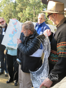
... hours. It will start at 2pm at the Main Road car park... hours. It will start at 2pm at the Main Road car park ...Local Historian Russell Yeoman and EDHS President Jim Connor with a map and aerial photograph of the area the heritage walk will cover. Newsletter No., 234, June 2017 Heritage Excursion - Saturday 1st July - Eltham Lower Park - Walk and Talk Eltham Lower Park has played an important part in the history of our area since the early days of European settlement when it was used by local residents as an informal racecourse. Prior to that its location at the junction of the Diamond Creek and the Yarra River made it an important meeting place for the Wurundjeri people. The park combines formal elements and sporting facilities with remnant bushland that is of environmental significance. It is home to sporting and horse riding clubs, popular play spaces and the Diamond Valley Miniature Railway, which attracts large numbers of visitors. The park will be the venue for our July excursion which will comprise a walk of about 3.5 km around the park and adjacent areas. Along the way we will discuss the history and natural history of the area. The path along the creek and the river provides a pleasant and scenic walk. This walk on Saturday 1st July is about 3.5 km in length and will take 2 to 2.5 hours. It will start at 2pm at the Main Road car park at the front of the park. (Melway ref 21 H 10). Born Digitalheritage excursion, activities, eltham district historical society, eltham lower park, russell yeoman, jim connor, guide -
 Eltham District Historical Society Inc
Photograph, Liz Pidgeon, Heritage Excursion; The 1901 Eltham Railway Walk, 3 May 2014, 3 May 2014
... Station car park (east/Main Road side) (Melway Ref. 21 J5).... Station car park (east/Main Road side) (Melway Ref. 21 J5 ...EDHS Member Doug Orford stands by a yarn bombing installation. ewsletter No. 216, May 2014 May Excursion – The 1901 Eltham Railway Walk The railway from Heidelberg to Eltham was opened in 1902. Over the previous year railway construction cut a curving swathe through Josiah Holloway’s 1851 Little Eltham subdivision. The survey plans for the railway show the owners and occupiers of land within Little Eltham affected by the railway alignment and for some distance each side. The plans show houses and other buildings but development at that time was rather sparse. Copies of these plans from the State Library of Victoria collection have been provided to the Society by Alan Sheehan. For our walk on 3rd May we intend to follow the railway from the Eltham Station to Ryans Road, which was the boundary of the adjoining Montmorency Farm. The return will be by way of nearby streets. Along the way we will discuss the details shown on the railway plans as well as more recent railway documents and photographs. At the conclusion and if time permits we can inspect the historical display at the Eltham Station. The walk is about 3 km in length and will take about 2.5 hours. It will start at 2 pm at the Eltham Railway Station car park (east/Main Road side) (Melway Ref. 21 J5).Born Digitalheritage excursion, activities, eltham district historical society, eltham railway station, eltham library, trestle bridge, yarn bombing, doug orford -
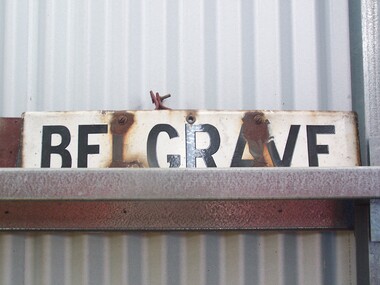 Puffing Billy Railway
Station Sign - Belgrave
... (which was approximately where the current suburban station car... (which was approximately where the current suburban station car ...Belgrave railway station is the terminus of the electrified line from Melbourne in Victoria, Australia, serving the eastern Melbourne suburb of Belgrave. Opened as Monbulk on 18 December 1900, it was renamed Belgrave on 21 November 1904. It was upgraded to a Premium station on 2 July 1996. The station was originally on the Upper Ferntree Gully – Gembrook narrow gauge line. It, along with the rest of the line, officially closed on 30 April 1954. However it saw further use between 1955 and early 1958, when trains were operated by the Puffing Billy Preservation Society in co-operation with the Victorian Railways. The station area re-opened on 19 February 1962 when the line as far as Belgrave was converted to broad gauge and used electric traction as part of the suburban network.[1] It has one island platform with two faces. It is serviced by Metro Trains' Belgrave line services The Puffing Billy Railway Belgrave station is located 100 metres north of the station and is accessible via a short footpath. It was required to be located further down the line than the original narrow-gauge station (which was approximately where the current suburban station car park is located). ref: https://en.wikipedia.org/wiki/Belgrave_railway_station photos at http://www.vicrailstations.com/Gembrook/Belgrave/Belgrave.htmlHistoric - Victorian Railways Station sign used at Belgrave StationStation Sign - Belgrave Metal sign - white enamel back ground with black letters Belgravepuffing billy, victorian railways, belgrave station -
 Wodonga & District Historical Society Inc
Photograph - Codling Collection 01 - Melba Theatre Wodonga and its Demolition
... with a supermarket and car park.... with the Shire Hall in 1971 and replaced with a supermarket and car park ...Miss Olive Codling was a Foundation Member and a Life Member of the Wodonga Historical Society. Many of her prize-winning photos are held in the Society Collection. She also held a range of roles and committee positions in a wide range of Wodonga community organisations. MELBA THEATRE, WODONGA operated in the Shire Hall building on the corner of High Street and Melbourne Road (Elgin Street), Wodonga. The Shire Hall was built in 1890. The date on the facade of the building represents the date of the formation of the Shire in 1876. In December 1929, Enterprise Pictures were screening films in the open air theatre adjacent to the Shire Hall or sometimes in the hall itself. In 1943 “Melba Theatre, Shire Hall” was advertised with that name for the first time. In 1948 Mr K Bounader, a picture proprietor from Holbrook with 39 years in pictures behind him assumed control of the Melba Theatre, Wodonga. The Bounader family continued to run the theatre well into the 1960s. The hall was also used for functions such as school socials and concerts. Competition from drive-in theatres and television had an impact on theatre audiences. Finally, the Melba Theatre screened its last film in 1968. A school speech night in 1969 is the last known event in the Melba Theatre. It was demolished along with the Shire Hall in 1971 and replaced with a supermarket and car park.These images are significant as they document an historic buildings in Wodonga which played an important part in the social life of the community.2 black and white photos of the Melba Theatre in Wodonga and its demolition Over doorway: "MELBA THEATRE"high st wodonga, melba theatre, wodonga buildings -
 Wodonga & District Historical Society Inc
Photograph - Ewart Bros. Menswear 1954 - 1998
... ' as it extended from High Street and through to the Coles supermarket car... High Street and through to the Coles supermarket car park ...EWART BROTHERS MENSWEAR In 1954 Clarrie and Jeff Ewart opened their business, Ewart Bros. Menswear in High Street, Wodonga. They united after having worked in separate menswear businesses following schooling at St Augustine’s in Wodonga. Clarrie had worked at Abikhairs and Jeff had his own business after working at Cann’s in Albury. Over more than 40 years in business Ewart Bros. operated from different premises, first in a rented premises at 192 High Street, then their own shop at 180 High Street in 1965. Their second site became known as the 'long shop' as it extended from High Street and through to the Coles supermarket car park. In 1962 they also opened a book shop at 192A High Street, advertising sales of books, stationery, cards and school book orders. Ewart Bros. was put up for auction in November 1995, with Clarrie and Jeff intending to retire. However the business was passed in at auction, so the business continued. On Friday 3rd April 1998 a clearance sale of all shop fittings was finally held, with Ewart Bros Menswear thanking the customers and friends who had supported them over the past 45 years. Jeff died on 5th April 1999 and Clarrie died on 20 May 2020.These items are significant because they represent an important and long serving business in the Wodonga community.A collection of photos and advertisements for Ewart Bros. Menswear in Wodongaewart bros. menswear, wodonga businesses, jsff and clarrie ewart -
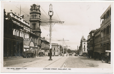 Ballarat Tramway Museum
Photograph - Digital image, Rose Stereograph Co, c1930
... to their removal. A number of motor cars are parked in the street, a dog... to their removal. A number of motor cars are parked in the street, a dog ...Yields information the appearance of Lydiard St north, centre poles and buildings.Digital image from the Wal Jack Ballarat Album of Rose Series postcard No. P 1787, of Lydiard St North looking south from near Mair St. shows the centre poles prior to their removal. A number of motor cars are parked in the street, a dog on the right hand side, and ESCo tram has just rounded the corner and about to climb the small hill. Published by Rose Stereograph Co., Armadale Victoria. For rear of postcard - see image i2.in pencil on rear "Old type of electric tram"trams, tramways, esco, lydiard st, poles -
 Ballarat Tramway Museum
Photograph - Digital image, Wal Jack, 14/03/1948 12:00:00 AM
... "boarding" the tram. Note the cars are parked with rear..." the tram. Note the cars are parked with rear into the kerb. See ...Yields information about the streetscape and use of the Gardens Parking loop in the late 1940's which was subsequently removed.Digital image from the Wal Jack Ballarat Album of a photograph of the No. 25 and 23 crossing in the Parking Loop (Gardens South Loop), Music for the People day, 14-3-1948. No. 25 has destination of City and No. 23, Gardens via Sturt. Note the dog "boarding" the tram. Note the cars are parked with rear into the kerb. See image i2 for rear of photograph. See image i3 for hi res scan of print. See image i4 for hi res scan of negativeOn rear of photograph in ink "SEC, Ballarat No. 25 to City, No. 23 to Gardens crossing at Parking Loop Ballarat Gardens, "Music for the People" day. 14-3-48" and Wal Jack stamp in top right hand corner with number "T96" written in.trams, tramways, gardens loop, wendouree parade, tram 25, tram 23 -
 Melbourne Tram Museum
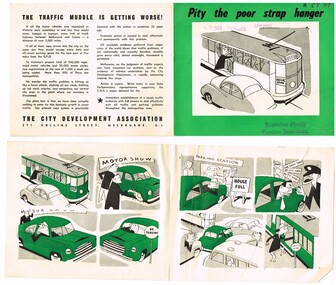
Pamphlet, City Development Association, "Pity the poor strap hanger", 1955
... of a man who travels by tram, buys a car, can't park it, traffic... set of a man who travels by tram, buys a car, can't park ...Pamphlet printed on off white paper with green overprint titled "Pity the poor strap hanger", containing a cartoon set of a man who travels by tram, buys a car, can't park it, traffic congestion and returns to the tram. On the read is note about the call by the City Development Association for a single traffic authority in Melbourne. Has notes about the parking and congestion problems. Has date April 1955 stamped on both copies. Assumed the printing date. Two copies held.Has AETA stamp on front cover with the letters "3CT 37"trams, tramways, melbourne, city of melbourne, public transport, road transport, traffic control, cartoons -
 Glenelg Shire Council Cultural Collection
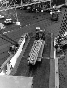
Photograph, Ro Ro vessel at Alcoa berth, n.d
... a cargo bay ramp. A forklift truck and several cars.... A forklift truck and several cars are in background, parked under ...Port of Portland Authority archives.Front: (no inscriptions) Back: 19 x 26 (lower left) (pencil-crossed out) P.11. (G) (lower left, pencil). 19 cm wide x 26 cm (lower centre) (pencil) (drawn crop marks on back edges, pencil).port of portland -
 Port Melbourne Historical & Preservation Society
Photograph - Joe and Teresa Cannatelli, first communion, Bay Street, Port Melbourne, 1973
... Street footpath outside Faram's, with four parked Holden cars... outside Faram's, with four parked Holden cars around them ...Donated by Tony CannatelliB&W photo of Joe and Teresa Cannatelli, dressed up for their first Holy Communion, late 1960s. They are standing on the Bay Street footpath outside Faram's, with four parked Holden cars around them.religion - roman catholic church (st josephs), joe cannatelli, teresa cannatelli