Showing 12580 items matching "development"
-
 Port Melbourne Historical & Preservation Society
Document - Newsletter, Vol 21, SCDC, Sandridge News, 1987- 1990
Sandridge News vol.21 (no date): a newsletter from the Sandridge Project, Sandridge City Development Companytown planning - proposals shelved - bayside, sandridge city development co pty ltd, scdc, barry kidd -
Port Melbourne Historical & Preservation Society
Document - Newsletter, Vol 23, SCDC, Sandridge News, 1987- 1990
Sandridge News vol.23 (no date): a newsletter from the Sandridge Project, Sandridge City Development Companytown planning - proposals shelved - bayside, sandridge city development co pty ltd, scdc, barry kidd -
Port Melbourne Historical & Preservation Society
Document - Newsletter, Vol 25, SCDC, Sandridge News, 1987- 1990
Sandridge News vol.25 (no date): a newsletter from the Sandridge Project, Sandridge City Development Companytown planning - proposals shelved - bayside, sandridge city development co pty ltd, scdc, barry kidd -
Port Melbourne Historical & Preservation Society
Document - Newsletter, Vol 26, SCDC, Sandridge News, 1987- 1990
Sandridge News vol.26 (no date): a newsletter from the Sandridge Project, Sandridge City Development Companytown planning - proposals shelved - bayside, sandridge city development co pty ltd, scdc -
Port Melbourne Historical & Preservation Society
Document - Newsletter, Vol 22, SCDC, Sandridge News, 1987- 1990
Sandridge News vol.22 (no date): a newsletter from the Sandridge Project, Sandridge City Development Companytown planning - proposals shelved - bayside, sandridge city development co pty ltd, scdc -
 Bendigo Historical Society Inc.
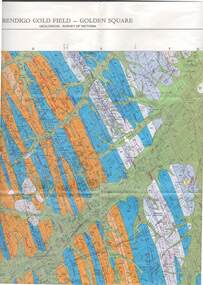
Map - STRUGNELL COLLECTION: GEOLOGICAL SURVEY OF VICTORIA, BENDIGO GOLD FIELD - GOLDEN SQUARE, 1992
Map, Geological Survey of Victoria, Bendigo Gold Field - Golden Square, Campaspe 10 000/2.2. Victoria 10,000.Dept. 0f Manufacturinf & Industry Development.map, bendigo, golden square gold field -
 Wangaratta RSL Sub Branch
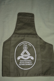
Uniform - Brassard
Worn by all Army personnel and civilian employees whilst deployed on research trips prior to camouflage uniforms.Green army armband/brassard with white writing in a white round circle.Australian Army, Engineering Development Establisment.brassard, arm band -
 Surrey Hills Historical Society Collection
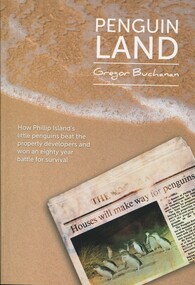
Book, Mitchell House, Penguin Land, 2015
Includes: viewing penguins in the 1920's; Summerland - AKT Sambell, 1944 Town Planning Act, the Summerland Comunity, and Summerland today. The author is a local resident and foundation member of the Surrey Hills Progress Association. Content is centred on the Phillip Island penguin parade and charts a conservation and development struggle that endured for almost 80 yearsContent is centered on the Phillip Island penguin parade and charts a conservation and development struggle that endured for almost 80 yearsSigned on inside cover page by author: Gregor Buchanan / 18/8/15penguins - phillip island, birds - victoria, wildlife conservation - victoria, phillip island penguin reserve - victoria, summerland estate -
Port Melbourne Historical & Preservation Society
Letter - Brian Robinson, EPA Chairman re cleanup of Bayside development site, Ewan Ogilvy's Bayside Papers, Box One, 1988
Ewan Ogilvy, former Melbourne Councillor and also of Community Services Victoria, Inner Urban Ministerial Advisory Committee and Uniting Church's Centre for Urban Research and Action (CURA), was instrumental in social justice approaches to town planning. He and CURA's Social Justice and the City Project funded Port Melbourne community groups protesting against the SCDC development in 1987. His files were presented to the Society in May 2001 on his preparation for leaving Victoria.From Ewan Ogilvy's chronologically organised 'Bayside Papers' relating to the proposed development of Port Melbourne industrial land in the late 1980s: Letter from EPA chairman Brian Robinson regarding cleanup of development site, included in bound black fileAll items signed 'Ewan Ogilvy'town planning, town planning - proposals shelved - bayside, public action campaigns, environmental issues, public housing, ewan ogilvy, centre for urban research and action, sandridge city development co pty ltd, scdc, brian robinson -
Port Melbourne Historical & Preservation Society
Document - SCDC Report, Ewan Ogilvy's Bayside Papers, Box One, 1987 - 1998
Ewan OGILVY, former Melbourne Councillor and also of Community Services Victoria, Inner Urban Ministerial Advisory Committee and Uniting Church's Centre for Urban Research and Action (CURA), was instrumental in social justice approaches to town planning. He and CURA's Social Justice and the City Project funded Port Melbourne community groups protesting against the SCDC development in 1987. His files were presented to the Society in May 2001 on his preparation for leaving Victoria.From Ewan OGILVY's chronologically organised 'Bayside Papers' relating to the proposed development of Port Melbourne industrial land in the late 1980s: Sandridge City Development Corporation report on hydraulic model testing and comp. modelled traffic estimates September 1987All items signed 'Ewan Ogilvy'town planning, town planning - proposals shelved - bayside, public action campaigns, environmental issues, transport - motor vehicles, ewan ogilvy, centre for urban research and action, sandridge city development co pty ltd, scdc -
Stawell Historical Society Inc
Book - Report, Stawell Impact Study, 1985
Socio - Economic Impact of major Industrial development in stawell. Includes Population, Business, Community Welfare, Housing and Migration. This Study Suggested by Barry Clugston a a F.A.C.S. ( Family and Community Services) meeting around 1982 ( + _) funding via Town Council by a Government Grant. Committee formed to overview researchers work and suggest areas of Interest. Interest to release of publication at a high level by town and Community. Navy Card Front Grid: Grey Spine BindingStawell Impact Study Street Ryan & Asociates Pty Ltd. Development Consultants Inside: Barry Clugston June 1985stawell -
Kew Historical Society Inc
Booklet - Yarraleen Estate, Bulleen, c.1966
Subdivision plans and real estate flyers/brochures reveal a number of aspects of urban development and history. The Kew Historical Society's collection of these plans, as well as advertisements extracted from magazines, cover key aspects of community development and architectural history of Kew and Kew Eat as well as surrounding suburbs. While most of the plans in the collection were gifted to the Society by the former City of Kew, a number of other plans and advertisements have been donated by individuals, of which this is an example.Original 8-page booklet advertising a new residential development in Bulleen entitled 'Yarraleen'. The glossy multi-colour brochure includes historic and contemporary photographs of the Yarra Valley, graphic designs of potential residential development, photographs of key facilities (Marcellin College, Golf links, local swimming holes, the Beaver Swim School, Carey Grammar School Oval and grandstand, shopping strips, and farmland).subdivisions -- bulleen (vic.), yarraleen estate -
Whitehorse Historical Society Inc.
Document, Ringwood
Development of the transport facilities from and to Ringwood with Development of Maroondah Highwayringwood, roads and streets, maroondah highway -
 Hume City Civic Collection
Photograph
Housing development spread to the banks of the Jacksons Creek at the east end of the town in the late 1970s.A coloured landscape photograph overlooking the Jacksons Creek and Sunbury township and showing housing development which is taking place on the horse shore bend also known as blueberry island on the opposite creek bank.jacksons creek, blueberry island, george evans collection -
 Federation University Historical Collection
Document, History of the Ballarat Technology Park, Oakbank
The Ballarat Technology Park is associated with Federation University Australia. The first stage commenced on 03 August 1989 when the first sod was turned by Hon, David White, Minister for Industry, Technology and Resources. John Beaumont was the Director of the Ballarat Technology Research and Development Park in 1989.Twenty items relating to the History of the Ballarat Technology Park as collected by John Parkin. .1) Handwritten notes by John Parkin on the history of the Ballarat Technology Park .2) Letter from A.E. Helyar (Shire of Buninyong Secretary), 08 March 1988 .3) Shire of Buninyong Minutes 07 June 1988 .4) Development of High Technology Activity by Jack Barker .5) Definition of a Technology Park by Derek Woolley .6) Shire of Buninyong minutes 28 June 1988 .7) Shire of Buninyong minutes 19 July 1988 .8) Invitation to a reception to commemorate the inauguration of the Ballarat Technology Park (John Parkin) by Shire of Buninyong President Cr Judith Coull to be held on 03 August 1989. .9) Invitation to a reception to the Ballarat Technology Park (John Beaumont) .10) Ballarat Courier article 04 August 1989 .11) Draft letter to Professor Geoffrey Blainey from John Parkin .12) Letter to the Editor from John Parkin, 18 December 2000 .13) University of Ballarat Development Appeal, 04 November 1994 .14 & .15) Invitation to installment dinner to celebrate the installation of Professor Geoffrey Blainey as Chancellor of the University of Ballarat to be held in the Union Building (now Albert Coates Building), Mt Helen campus .16) Letter to the editor from John Parkin .17) Letter from John Beaumont, 25 November 1994 .18) Invitation to the opening of the ISSC Southern Region Data Centre to be held on 24 November 1995. .19) Letter from Barry Traynor, 13 December 1995 .20) Planning Scheme information relating to the LaTrobe Research and Development Zone. .1) 2nd May 2005 History of Technology Park (I.T. centre) The history of the Technology Park started back in the mid-1980s. At the time I was a Buninyong Shire Councilor and as such I was Buninyong's representative on the then Ballarat Development Committee. At one of our meetings we received a request for information on a suitable site for a technology park. The requirements were for a site adjacent to a tertiary institution, secluded for security purposes and large enough to contain such a development. The next morning I contacted our Shire Engineer at the time, Newell Barrett and we drove around the area we both agreed that the current site was the most suitable we saw to meet the requirements. At the time it was owned by George Morrison. however the original enquiry to the B.D.C. came to nothing but the Shire Council and the B.D.C. decided to investigate the possibility of the site becoming a technology Park and information was collected. At about this time Mr Morrison put the property on the market and it was bought by a Ballarat builder, Mr John Beaumont, with the idea of developing it as a residential area. Council then arranged a meeting with Messrs Morrison and Beaumont to discuss the matter. I remember Mr Morrison saying he did not care what was done with it he just wanted to sell it and move down to the coast. Mr Beaumont, on the other hand, said he wasn't ready to retire yet and the idea interested him. As a result a committee consisting of the B.C.A.E., B.D.C. and Buninyong Shire Council (and Mr Beaumont) was formed to plan the development and rezone the area to technology park. It was previously zoned residential land and would seem to have been suitable for sub-division and residential development - its close proximity to the College being a major factor in its favour. The point of this is if Mr Beaumont had insisted on pursuing his original plan and had opposed the rezoning, I am quite confident he would have won an appeal at the A.A.T . (Administrative Appeals Tribunal - forerunner of V.C.A.T.) and the I.T. centre would not have got off the ground and the area would be covered with houses. But Mr Beaumont did go into the project with enthusiasm and the first stage was commenced on the 3rd August 1989 when the first sod was turned by Hon. David White, the Minister for Industry, Technology and resources (See the Courier 4th August 1989) Mr Beaumont went overseas to study similar parks and look for tenants. Unfortunately government did not support the project as they have now and apparently Mr Beaumont was ahead of his time for the private sector so Mr Beaumont could not continue the development and the site eventually passed to the College. I personally think more could have been done ... The work done by the Buninyong Shire Council and Ballarat Development Committee seems to have been forgotten as according to the Courier December 21, 2000 we are told the Park opened in 1995 as a joint venture between the City and the University. As a former Councillor said to me on the day "What happened to the plaque David White unveiled in 1989!" If there is any other information you want, please contact me. You may use my file for reference. Kind regards John Parkin PS I always felt a bit guilty that I encouraged John Beaumont and he was left in the lurch. ballarat technology park, parkin, john parkin, helyar, barker, woolley, shire of buninyong, beaumont, blainey, geoffrey blainey, southern region data centre, greenhill enterprise centre, stan jeffrey, jeffrey, john beaumont, david white -
Whitehorse Historical Society Inc.
Pamphlet, Blackburn South Recreation Trail, 1989
Pamphlet outlining the history of the linear park along the alignment of the discontinued Healesville freeway.Pamphlet outlining the history of the linear park along the alignment of the discontinued Healesville freeway. It includes plans for the immediate future, the development of Fulton Reserve and lists the Committee of Management. A plan of the area is on the verso.Pamphlet outlining the history of the linear park along the alignment of the discontinued Healesville freeway.wurundjeri walk, fulton reserve, blackburn south recreation trail, city of nunawading -
 Surrey Hills Historical Society Collection
Book, City of Camberwell Community Information Services: Paper 8, 1982
47p;i lll. This paper brings together materials on community information needs and services in the City of Camberwell, and suggests a broad framework and strategy for the development of information services.47p;i lll. This paper brings together materials on community information needs and services in the City of Camberwell, and suggests a broad framework and strategy for the development of information services.information services, community groups, city of camberwell -
Lakes Entrance Historical Society
Book, Morrissey D W and Morrissey E W, Lakes Entrance a Short History and Tourist Guide
A short history of lakes Entrance from early settlement, including references to forest survey, land sales, shipping, fishing industry and development of the town and tourist industry A short history of lakes Entrance from early settlement, including references to forest survey, land sales, shipping, fishing industry and development of the town and tourist industrysettlers, land settlement -
Port Melbourne Historical & Preservation Society
Pamphlet, Ewan Ogilvy's Bayside Papers, Box Three - Beacon Cove - A Future for Princes Pier, 1990s
Ewan OGILVY, former Melbourne Councillor and also of Community Services Victoria, Inner Urban Ministerial Advisory Committee and Uniting Church's Centre for Urban Research and Action (CURA), was instrumental in social justice approaches to town planning. He and CURA's Social Justice and the City Project funded Port Melbourne community groups protesting against the SCDC development in 1987. His files were presented to the Society in May 2001 on his preparation for leaving Victoria.From Ewan OGILVY's chronologically organised 'Bayside Papers' relating to the proposed development of Port Melbourne industrial land in the late 1980s: 'Beacon Cove - A Future for Princes Pier' - promotional brochure for development of Princes Pier (Mirvac Beacon Cove Stage 2)Signed 'Ewan Ogilvy'town planning, town planning - proposals shelved - bayside, environmental issues, ewan ogilvy, mirvac -
Port Melbourne Historical & Preservation Society
Document, Ewan Ogilvy's Bayside Papers, Box Three - Inner Urban Ministerial Advisory Committee - Report on Social Impact Work for major Developments Jan 1988, 1987
Ewan Ogilvy, former Melbourne Councillor and also of Community Services Victoria, Inner Urban Ministerial Advisory Committee and Uniting Church's Centre for Urban Research and Action (CURA), was instrumental in social justice approaches to town planning. He and CURA's Social Justice and the City Project funded Port Melbourne community groups protesting against the SCDC development in 1987. His files were presented to the Society in May 2001 on his preparation for leaving Victoria.From Ewan Ogilvy's chronologically organised 'Bayside Papers' relating to the proposed development of Port Melbourne industrial land in the late 1980s: Stapled photocopies of Inner Urban Ministerial Advisory Committee - Report on Social Impact Work for major Developments Jan 1988Signed 'Ewan Ogilvy'town planning, town planning - proposals shelved - bayside, public action campaigns, environmental issues, public housing, missions to seamen, ewan ogilvy, centre for urban research and action, sandridge city development co pty ltd, scdc, linton r lethlean, barry pullen - mlc -
Clunes Museum
Plan - Building Plans, Proposed Layout Plan Clunes Neighborhood House, 12 June 2009
Architectural plan of proposed Clunes Neighborhood House Free Lending Library Development.A1 size architectural plan of proposed Clunes Neighborhood House Free Lending Library Development. Includes floor plan, front and side elevations. Dated 12 June 2009 by Kevyn Joy Architects.clunes neighbourhood house, kevyn joy architects, building plans -
Glenelg Shire Council Cultural Collection
Photograph, View of Portland Harbour and Port, c. 1971
Port of Portland Authority archives.Front: (no inscriptions) Back: verso - 'Portland Development Committee Publicity Section, Division of Industrial Development Reg no - 56-43.' -
Whitehorse Historical Society Inc.
Pamphlet, Morack Public Golf Course, c1985
Pamphlet describing the Morack Public Golf Course in Vermont South.Pamphlet describing the Morack Public Golf Course in Vermont South. Its history is outlined and its proposed development. Course maintenance and watering systems are described. The verso is a detailed plan of the course.Pamphlet describing the Morack Public Golf Course in Vermont South. morack golf course, dandenong valley metropolitan park -
 Surrey Hills Historical Society Collection
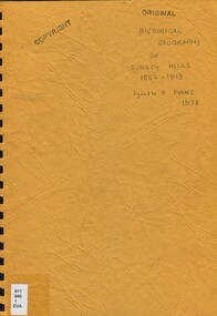
Book, An historical geography of Surrey Hills, 1882-1913, 1979
A thesis submitted for the Degree of Bachelor of Arts with Honours. This thesis presents in a description form, the development of Surrey Hills, an eastern suburb of Melbourne. The settlement and growth from a rural district in 1882 to a suburban centre in 1913.This thesis presents in a description form, the development of Surrey Hills, an eastern suburb of Melbourne. The settlement and growth from a rural district in 1882 to a suburban centre in 1913.surrey hills, geography, topography, j. knipe, land use, population -
 Port Fairy Historical Society Museum and Archives
Photograph
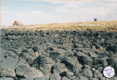
South Beach Development looking from rocks to Mal Dorea’s housesouth beach, development, rocks, bluestone, mal dorea, house, building -
Bialik College
Mixed media (item) - 2011 Library Project Exterior images
Images taken in association with the development of the school library at Bialik College in 2011. 2010s, 2011, library, building, heritage, development, bialik college -
 Surrey Hills Historical Society Collection
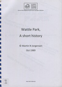
Book, Wattle Park: a short history, Oct-89
This book includes a description of the early settlement of Wattle Park; who owned the farms prior to it becoming parkland; and the development and management since including the Melbourne and Metropolitan Tramways Board.This book includes a description of the early settlement of Wattle Park; who owned the farms prior to it becoming parkland; and the development and management since including the Melbourne and Metropolitan Tramways Board.wattle park, trees, box trees, golden wattle trees, she-oak trees, (mr) james atkinson, aborigines, first tree, (mr) hector bell, croquet, golf, orienteering, (mr) henry de carle, (mr) john lawler, (mr) walter craig, (mrs) eliza welch, the grange, (miss) effie eliza ball, hawthorn tramways trust, (mr) - membrey, metropolitan tramways park, (mr )david pureau, by-laws, g. t. usher, o. fenwick, f. c. garyder, e, bennet, a. snowden, g. tweedy, (mr) (sir) arthur stanly, (mr)alan holt, (mrs) a bennet, world war, 1939-1945, eucalypts, elm trees, ash trees, (ms) faye shepherd -
Lakes Entrance Historical Society
Book, Adams John, The Tambo Shire Centenary History, 1981
A history of the Shire of Tambo, East Gippsland, Victoria, including many aspects of settlement, development, industries, transport, and the hardy people who tamed this varied and often inhospitable region.A history of the Shire of Tambo, East Gippsland, Victoria, including many aspects of settlement, development, industries, transport, and the hardy people who tamed this varied and often inhospitable region.land settlement, transport -
Lakes Entrance Historical Society
Book - Arthur Phillip, Hughes, Thea Stanley, 1982
An account of the life and achievements of Arthur Phillip, commander of the First Fleet, sent to Botany Bay; the relocation to Port Jackson, and the development of the settlement under his governorship. Written for students.An account of the life and achievements of Arthur Phillip, commander of the First Fleet, sent to Botany Bay; the relocation to Port Jackson, and the development of the settlement under his governorship. Written for students.law, government, land settlement -
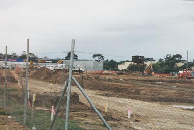 Sunbury Family History and Heritage Society Inc.
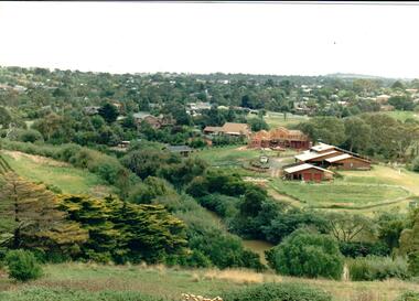
Photograph, 13 April 2000
In 2000 work commenced on the further development of railway land on the west side of Sunbury station for the construction of commercial and entertainment facilities. Prior to this time the land had been undeveloped and was often used to accommodate visiting circus troupes. Cereal storage silos also occupied this area for some time. The development of this area has been a reflection of the rapid expansion of settlement within Sunbury and surrounding areas that occurred during the early years of the twentieth century.A coloured photograph of a fenced off area undergoing development with earthmoving equipment and trucks in operation and some commercial buildings visible in the middle distance.sunbury railway station