Showing 1245 items matching "explorers"
-
 Eltham District Historical Society Inc
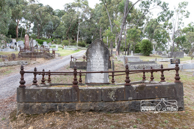
Photograph, Peter Pidgeon, Grave of Myles Archibald Lyons and children, Eltham Cemetery, Victoria, 5 April 2021
In 1872 Senior Constable Myles Lyons replaced Peter Lawlor at Eltham Police Station. Earlier in his career, he had taken part in a search (one of many) for missing explorers Burke and Wills. At Eltham, his arrests ranged from minor instances of theft, vandalism and larrikinism to serious cases of manslaughter, murder and attempted suicide. He even tracked down and arrested two Norwegian seamen charged with desertion from their vessel. While conveying a prisoner from Eltham to Melbourne in 1886, he was attacked by the prisoner en route. It seems that much of the local news in the Evelyn Observer was provided by Eltham Shire Secretary C.S. Wingrove. In 1878, Eltham residents held an “Indignation Meeting” at the Evelyn Hotel, complaining that the reporting had denigrated Lyons’ conduct and had stigmatised the character of Eltham’s inhabitants. They passed a resolution castigating Wingrove and supporting Lyons. Wingrove claimed to have been misconstrued. But in 1887 the Evelyn Observer carried a long ranting vitriolic editorial. It complained about inadequate policing generally, then attacked Lyons personally, saying that (although efficient in the past) he had now become incompetent and needed to be replaced by a younger more energetic man. Myles Lyons retired due to ill health in 1889 but remained in Eltham until his death in 1899. He is buried in Eltham Cemetery with his wife Flora and five of their children. Four sons moved to Western Australia where two were killed in unconnected railway accidents. In Loving Memory of Myles Archibald Beloved Husband of Flora Lyons Who Departed This Life 19th August 1899 Also their beloved Children Archibald Myles Who died 28th June 1865, aged 18 months Edith May Died 9th November, 1884, aged 1 year Hester May Died 17th July, 1887, Aged 14 months Flora Louisa Died 19th August, 1889, aged 14 years Joseph William Died 1st August, 1904, aged 27 yearsBorn Digitaleltham cemetery, gravestones, archibald myles lyons, edith may lyons, flora louisa lyons, flora lyons, hester may lyons, joseph william lyons, myles archibald lyons -
 Eltham District Historical Society Inc
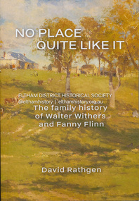
Book, David Rathgen, No Place Quite Like It; The family history of Walter Withers and Fanny Flinn, 2023
Summary For over 250 years the Withers family of Birmingham worked as tailors, sometimes also as butchers. During the Georgian era, English society changed and the Withers family with it. First came a gentleman amateur artist in the form of Edward Weston Withers, grandfather of Walter Withers. Then Edwin Withers, Walter Withers' father, took to tobacco, rope and twine manufacturing which put an end to the traditions of butchery and tailoring.The origins of Walter's painterly ambitions are explored. There was a physical altercation between Walter and his father, Edwin. That fight emerged out of contradictory expectations between Walter's father, Edwin and his grandfather Edward. Those expectations and the societies which kindled them contributed to Walter's character and art. Up until now there has been no family history about Walter Herbert Withers (1854-1914) a notable Australian landscape artist of the Heidelberg school and friend to Tom Roberts, Frederick McCubbin, Arthur Streeton and Clara Southern. Walter, the son of a rich Victorian businessman, married Fanny Flinn, the daughter of a commercial salesman who also owned part of a Birmingham brewery. In No Place Quite Like It, Walter, his wife Fanny and his family are depicted against the social contexts in which they each grew up. Our appreciation of Walter Withers' art is expanded: by knowing those forces which helped shape his early years and how he responded to them; by gaining new insights into his origins and how he grew into the man he was. We also gain a fresh appreciation of his wife Fanny, and the influence she had upon him, their children, and upon the society in which she lived. Includes 200 pages of text, Prefaces by Andrew Mackenzie OAM (art historian), and Eileen Mackley AM (President, Victorian Artists Society), Bibliography and an Index, extensive images, maps, charts and family trees, provide a visual porthole through which an insight might be had into the lives and times of Walter Withers and his family history.walter withers, fanny withers (nee flinn), family history -
 Nillumbik Shire Council
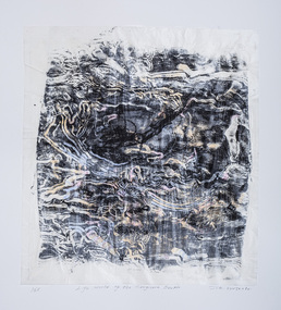
Print (woodcut and etching on chine-colle): John WOLSELEY (b.1938 Somerset, UK; arrived 1976 Melb., AUS), John Wolseley, 'Life world of the Longicorn beetle' from the 'Baldessin & Friends commemorative folio', 2016
Painter, printmaker and installation artist John Wolseley was born in Somerset, England. He lived and worked throughout Europe before relocating to Australia in 1976. His work explores how people dwell and move within landscape. Wolseley see's himself as a hybrid mix of artist and scientist; one who tries to relate the minutiae of the natural world - leaf, feather and beetle wing - to the abstract dimensions of the earth's dynamic systems. Using techniques of watercolour, collage, frottage, nature printing and other methods of direct physical or kinetic contact Wolseley finds ways of collaborating with the actual plants, birds, trees, rocks and earth of a particular place. George Baldessin was one of the first artists John Wolseley met when he arrived in Australia in 1976. Both immigrated to Australia and connected through this shared experience. They were both at 'Realities Gallery' with Marianne Baillieu in the 1970s and 80s. George Baldessin (1939-1978) was born in San Biagio di Callalta, in the Veneto in Northern Italy and arrived in Australia ten years later. A printmaker and sculptor he built his bluestone studio at St Andrews (Nillumbik) in 1971 with his partner Tess and the three Hails brothers, Rob, Doug and Don. Made of recycled materials the studio today contains all of George’s equipment including the large press, which he modelled himself with the help of Neil Jeffrey (Enjay Presses). George won many prizes throughout his career and is represented in many of Australia's public art collections including his famous 'Pears' sculpture in front of the National Gallery of Australia, Canberra. In 1975 he represented Australia in the Sao Paulo Biennale, before living and working in Paris until his return to St Andrews in 1977. In 1978 George was killed in a car accident aged 39 years. In 2001 Tess returned to St Andrews to reclaim the run-down studio and reconstitute it as The Baldessin Press & Studio - a printmaking retreat. It operates in George’s memory, so that artists may continue to create, perpetuating the generous spirit of George. 'Life world of the Longicorn beetle' is one of eight prints in the 'Baldessin & Friends commemorative folio. The folio was conceived by Tess Edwards as a fundraising initiative in celebration of the The Baldessin Press & Studio's fifteen year anniversary, and as a way to honour George Baldessin's memory. The Baldessin Press & Studio is a not-for-profit organisation created in memory of the late George Baldessin (1939-1978), whose original studio is now open to the public for creative use and as a practical legacy to living artists. The Studio is located in St Andrews, Nillumbik. The folio is a unique coming together of seven very different and acclaimed artists who are connected by their friendship to the missing eighth member, George Baldessin. Communion and collaboration with nature are central to Wolseley's practice. He assembles different drawing methods to represent a kind of inventory or document about the state of the earth. His interest is to paint the processes and energy field of the living systems of this land. 'Life world of the Longicorn beetle' is his continued exploration of Australia's natural eco-systems. The beetle attacks the eucalypt and in the process of tunnelling into the wood of the tree leaves scribbly patterns. The work celebrates the cycle of life, and the wisdom and delicacy of these creatures. This three dimensional work consisting of three layers of paper is a varied edition, offering just the slightest difference between each print, reflective of variation in nature. The found log used as a woodcut acknowledges the interconnectedness of nature and living beings; the log is not apart from the art and the beetle has become an active artistic collaborator. An intimate and layered print of a tree log with line trails from the Longicorn beetle. Patches of pink, yellow and orange watercolour placed randomly. Woodcut from found log and etching on chine-colle with water colour on Gampi (top layer), Mulberry (middle layer) and Arches (bottom layer) paper. In pencil (handwritten): low plate: left '14/25' (edition); centre 'Life world of the Longicorn beetle' (title); right 'John Wolseley' (signature); low paper: right emboss 'GB' (Baldessin Press & Studio monogram)woodcut, etching, chine-colle, landscape, environment, longicorn beetle, print, baldessin, ekphrasis2018, eco, mixed media -
 Federation University Historical Collection
Pamphlet, University of Ballarat Australian Studies Centre, University of Ballarat Conference Pamphlet, 12/1999
A conference in memory of Kevin Livingston to celebrate the role the Irish in Ballarat played in the formation of the nation..1) Light green tri-folded A4 pamphlet .2) Program for the 'Through Irish Eyes' Conference, A conference held in memory of Associate Professor Kevin T. Livinsgston by the University of Ballarat Australian Studies Centre, 3-5 December 1999. Speakers were: * Anne Beggs Sunter - 'irish Republican Echoes at Eureka * Jill Blee - 'Portrait of a Ballarat Irishman/woman * Dianne (Leonard) Cahir - 'The Irishness of Dunnstown * Dianne Campbell - Sir Henry Cuthbert * Dermot Clancy - Colonial Clergy - All Hallows College and the Australian Mission in the 19th Century. * Anne Cunningham - Dom bernard Smith's Australian Mission * Mella Cusack - Relations between the Young Irelanders and the Catholic Clergy in Australia * John Daykin - He that is Not With Me is Against Me: The Role of the Irish in the Defeat of conscription, Ballarat 1916-1917 * Dr Frances Devlin Glass - '[T]ouches of nature that make the world kin: Furphy, Race and Anxiety' * Helen Kinloch - Bernard O'Dowd,, and dreams of a Golden age in Australia' * Associate Professor Rederic Lacey - 'Exploring Pathways Towards reconciliation Through Encountering Our Shared Histories' * Dymphna Lonergan - 'Sounds Irish' * Dr David Lucy - ' Remarks on the Decline of Irish Language' * Patrick McCormack - The Irish Factor in the Campaign for Federation in New South Wales * Siobhan McHugh - 'In Search of Soul: One Irishwoman's Journey in Australia' * Ken Mansell * Dr Val Noone - 'the Irish in collingwood 1860-1900: Family Tree Meets historical Record * Ambassador Richard Anthony O'Brien * Terrence O'neill-FitzSimons - "Francis Thomas Cusack-Russell' * Professor Bob Reece - 'The making of the Eureka Film' * Edward O'Reilly - 'John Boyle-O'Reilly: Journeys and Monuments * Dr Chris Watson - 'Around the Boree Log and the identity of Irish Australians' * Dorothy Wickham - 'Saints or Sinners?: The Influence on Ballarat's Female refuge by Irish Women' * Christine Wright - 'A Stately Landmark: Adam Loftus Lynn .3) newspaper article on the conference from The Courier, 06/12/1999 - 'Irish Celebrate Their Role in City'Black print on light green paperaustralian studies, university of ballarat, kevin livingston, mt helen campus, "through irish eyes", jill blee, david james, rod lacey, val noone, dianne campbell, christine wright, terence o'neill-fitzsimons, helen kinloch, diane cahir, dorothy wickham, edward reilly, mella cusack, anne beggs-sunter, patrick mccormack, anne cunningham, shane carmody, dermot clancy, francis devlin-glass, chris watson, david lucy, dymphna lonergan, richard o'brien, bob reece, peter kennedy, gough whitlam, australian studies, university of ballarat, kevin livingston, mt helen campus, "through irish eyes", jill blee, david james, rod lacey, val noone, dianne campbell, christine wright, terence o'neill-fitzsimons, helen kinloch, diane cahir, dorothy wickham, edward reilly, mella cusack, anne beggs-sunter, patrick mccormack, anne cunningham, shane carmody, dermot clancy, francis devlin-glass, chris watson, david lucy, dymphna lonergan, richard o'brien, bob reece, peter kennedy, gough whitlam, genealogy, family history, irish australians, irish -
 Eltham District Historical Society Inc
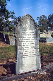
Negative - Photograph, Harry Gilham, Grave of Myles Archibald Lyons and children, Eltham Cemetery, Victoria, Sep 2009
In 1872 Senior Constable Myles Lyons replaced Peter Lawlor at Eltham Police Station. Earlier in his career, he had taken part in a search (one of many) for missing explorers Burke and Wills. At Eltham, his arrests ranged from minor instances of theft, vandalism and larrikinism to serious cases of manslaughter, murder and attempted suicide. He even tracked down and arrested two Norwegian seamen charged with desertion from their vessel. While conveying a prisoner from Eltham to Melbourne in 1886, he was attacked by the prisoner en route. It seems that much of the local news in the Evelyn Observer was provided by Eltham Shire Secretary C.S. Wingrove. In 1878, Eltham residents held an “Indignation Meeting” at the Evelyn Hotel, complaining that the reporting had denigrated Lyons’ conduct and had stigmatised the character of Eltham’s inhabitants. They passed a resolution castigating Wingrove and supporting Lyons. Wingrove claimed to have been misconstrued. But in 1887 the Evelyn Observer carried a long ranting vitriolic editorial. It complained about inadequate policing generally, then attacked Lyons personally, saying that (although efficient in the past) he had now become incompetent and needed to be replaced by a younger more energetic man. Myles Lyons retired due to ill health in 1889 but remained in Eltham until his death in 1899. He is buried in Eltham Cemetery with his wife Flora and five of their children. Four sons moved to Western Australia where two were killed in unconnected railway accidents. In Loving Memory of Myles Archibald Beloved Husband of Flora Lyons Who Departed This Life 19th August 1899 Also their beloved Children Archibald Myles Myles died at age 75 on the same day as his 14 year old daughter, Flora Louise. Who died 28th June 1865, aged 18 months Edith May Died 9th November, 1884, aged 1 year Hester May Died 17th July, 1887, Aged 14 months Flora Louisa Died 19th August, 1889, aged 14 years Joseph William Died 1st August, 1904, aged 27 yearsRoll of 35mm colour negative film, 6 stripsKodak GC 400-9eltham cemetery, gravestones, edith may lyons, flora louisa lyons, flora lyons, hester may lyons, joseph william lyons, myles archibald lyons, police, archibald myles lyons -
 Federation University Historical Collection
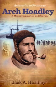
Book, Jack A. Hoadley, Antarctica to Footscray: Arch Hoadley, 2010, 2010
Predominantly brown covered paperback of 460 pages featuring an image of Arch Hoadley in Antarctica on the cover.non-fictionballarat school of mines, antarctica, footscray technical school, baden powell, scouts, douglas mawson, arch hoadley -
 Federation University Historical Collection
Booklet, Extra Muros, 1947, 1947
Each year World War One and World War Two veteran, and Ballarat Teachers' College Principal addressed the College community for ANZAC Day. The following are excerpts of his 1947 address. "...But we should do more than remember, and instead of pausing once a year for this purpose is should be our aim to remember daily - every day should be an Anzac Day so that we shall be inspired to take stock of ourselves if we are tryig to be worthy of almidst 100,000 dead who died to keep this country free to progress nobly towards a worthy goal, What are we dong about it? As a body of teachers er should be particulalrly concerned, as in our hands largely the growth of the children lies. In the schools we can do much in our work of every day to develop right standards and a better outlook amongst the children it is our privilege to teach. We can successfully teach the three "R's" but if this is all we do then we have failed. Is should be our aim, living in the spirit of those who gace so much, to dedicate ourselfes to the work of teaching young people how to live; to train them gently in ethical standards of conduct; to take responsibility; to live through the operation with otherts; to be prepared to give service without thought of personal gain; to realise to the full all that is best in them for the good of all. What we should do and how it is to be done is difficult to descibe, but if we ourselves have taught something of the Anzac Sprit we shall not fail. In particular, we shold take care of the orphan and th child of the disabled soldier. We should explore all avenues to see what that these children get every opportunity for higher education. As far as it lies in our power we should see that these children do not suffer - thus the legacy of war is ours. In a few months you will be going out to your schools. You will have young children around you. Let you arims be high. Try to live worthily and let your little community be the better and the finer for your coming. If you achiec somethig of thise then 100,000 shall nit have died in vain." Blue soft covered, stapled booklet named 'Extra Muros', the magazine of the Ballarat Teachers College, ANZAC Day. The contents include: The Year's Sport, J. Arthur Rank; Music; Dingo Blood; Anzac Day 1947; History of Sport; J. Arthur Rank Named images include: staff and students; Sports Committee; Social Committee; Student Council; Magazine Committee' Daylesford Camp; Anglesea Camp; Grampians Camp; Exies, College staff and students;A number of authorgraps are written into the back page. ballarat teachers' college, ellwood, lord, robinson, tozer, connelly, pattenden, collins, blake, faulds, sunderland, miller, bryan, yeo, frank lord, lindsay w. harley, lindsay w. harley, anzac day -
 Federation University Art Collection
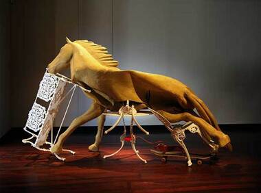
Sculpture - Sculpture - Installation, 'Dead Still Standing' by Lou Hubbard, 2015
Lou HUBBARD (1957 -) Born Brisbane, Queensland After a career in the film and television, Melbourne based artist Lou Hubbard completed a Master of Fine Art at RMIT University in 2001. She works primarily with video and installation, and has exhibited widely throughout Australia and internationally, Lou Hubbard is currently the Head of Photography at the Victorian College of the Arts. In announcing the award 2015 Guiguis New Art Award the judges applauded Lou Hubbard on her compelling installation, which comprised a deflated, disembowelled latex horse collapsed over a Coalbrookdale patio chair, table and bench seat situated over a skateboard and plastic dog. “Occupying a space between the traditions of equine, assemblage and unmonumental sculpture, Lou Hubbard’s Dead Still Standing confounds and compels viewers in its uncanny play of materials and movement,” senior curator, contemporary art, National Gallery of Victoria and judge Max Delany said. “In this elaborate yet concise work, Hubbard has created a form of surprising and unsettling effect that reflects our experience of a world in translation.” The win came as a surprise for Hubbard, who said she was overwhelmed at the talent of all 15 finalists. “I was so surprised, because I was in good company with the other artists, who were all quite extraordinary,” she said. “In the nature of the competition, I feel very lucky.” With multi-layer meanings to her piece, Hubbard said it was actually Ballarat’s rich history that inspired her work. She said it was the Ballarat goldfields and the idea of what horses might have gone through during those years that gave her a concept to work with. But that wasn’t the only source of ideals portrayed in the piece – Hubbard also explored the effect training had on horses. “The horse stands in a way that portrays (how) the human exhorts the way of training,” she said. “The horse is edging like it wants to move, which is impossible, and the furniture acts in lots of ways. The chair, for example, is like the horse’s ribs, which are being ripped out.” It was these multiple meanings that also had the curator of the Post Office Gallery, Shelley Hinton, impressed with the work. “The work challenges us ethically and culturally, in a way that pleads for analysis, as we do in our complex daily lives,” she said. Lou Hubbard's 'Dead Still Standing' won the was awarded the prestigious $20,000 Guirguis New Art Prize in 2015. The Federation University Guirguis New Art Prize was a national biennial and aquisitive contemporary art prize. The $20,000 biennial acquisitive prize was sponsored by Ballarat surgeon Mark Guirguis, administered by Federation University Australia and presented in partnership with the Art Gallery of Ballarat.The genesis of the prize was to raise the profile and encourage the Art School of what was then Ballarat University. lou hubbard, guirguis, guirguis new art prize, sculpture, horse, animal, installation artwork -
 Flagstaff Hill Maritime Museum and Village
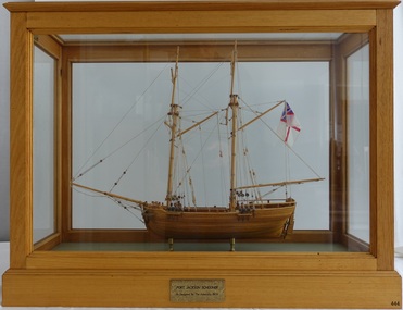
Craft - Ship Model, Port Jackson Schooner
This ship model is of a Colonial Port Jackson schooner, originally designed by the British Admiralty in 1803 as a response to the request of New South Wales' Governor Arthur Phillip. The drafts for the original plans are in Greenwich, UK, in the National Maritime Museum. The model is a Ledition edition, number 2 of 5, modelled by Bill Leonard. The model is rigged and decked in the manner of David McGregor. The flag on model of Port Jackson schooner is that of the British White Ensign which was used as the flag design of the Royal Australian Navy from 1911 - 1967. In 1785 the First Fleet arrived in the new British colony of Port Jackson (now Sydney Harbour) in New South Wales and Arthur Phillip was appointed as the first Governor. The following year Governor Phillip asked the English Royal Navy to provide drafts and materials for two ships for use in the Port Jackson colony for exploring and surveying rivers. The vessels needed a shallow draught and to be made from local cedar timber. He asked for the frames of the schooners to be provided along with shipwrights to assemble them. Many years later, in 1803, Governor Phillip’s request was fulfilled but he had already resigned from his post. The drafts titled ‘Schooner for Port Jackson’ were despatched by the Royal Navy from England to Australia. The original draft is still in the National Maritime Museum in Greenwich, UK. Meanwhile, the NSW Government had already built various other ships before 1803. In 1797 His Majesty’s Dockyard was opened at Port Jackson for building larger vessels. The Royal Navy’s 1803 design of a ‘Schooner for Port Jackson’ has been recognised on the obverse of Australia’s twenty dollar banknote since 1994. A sketch of the schooner is beside the portrait of Mrs Mary Reibey, who arrived as a convict and rose to become a respected and successful owner of a cargo shipping business. Her fleet included the Mercury, a schooner similar to the 1803 design for the Port Jackson schooner. Although the 1803 plans for a ‘Schooner for Port Jackson’ are commonly believed to be used for the first ship built in Australia, no records have been found of any ships being built according to these plans. However, it can be claimed that the plans were the ‘first Royal Navy plans made for a ship for use at Port Jackson, and to be built at Port Jackson, in Australia’. William (Bill) Leonard passed away on March 1st 1995.This ship model is significant for its representation of an early Australian colonial schooner. The 1803 Royal Navy’s plans for the colonial ‘Schooner for Port Jackson, were for the first ship specifically designed by the Royal Navy to be built and used in Port Jackson, for use in exploration and surveying of Australian ports and rivers. The plans are associated with Australia’s colonial settlement in the late 1700s. This ship model is significant for its association with the emblems of Australia’s history on the twenty dollar banknote. The colonial Port Jackson schooner is considered significant to Australian history, and represented on the 1994 twenty dollar banknote and its new version being rolled out in October 2019.Ship model of a colonial Port Jackson Schooner. Two-masted sailing ship displaying the flag named The British White Ensign. Mode of light coloured stained timberl is mounted on brass legs inside a glass case with timber frame and base. Metal engraved plaque states that the model is as designed by The Admiralty in 1803. Model is a number 2 of 5 in a limited edition, made by Bill Leonard.Engraved on metal plaque "PORT JACKSON SCHOONER / As Designed By The Admiralty. 1803"flagstaff hill, warrnambool, shipwrecked-coast, flagstaff-hill, flagstaff-hill-maritime-museum, maritime-museum, shipwreck-coast, flagstaff-hill-maritime-village, ship model port jackson schooner, sailing ship, limited edition model, model maker bill leonard, david mcgregor design, maritime trade, maritime vessel, colonial port jackson schooner, pacific island trade in early 1800s, sydney cove, governor arthur phillip, governor philip gidley king, a schooner for port jackson, national maritime museum greenwich, australian $20 banknote -
 Flagstaff Hill Maritime Museum and Village
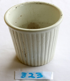
Domestic object - Pudding Mould
One of the first documented mentions of pudding can be found in Homer's Odyssey where a blood pudding roasted in a pig's stomach is described. This original meaning of a pudding as a sausage is retained in black pudding, which is a blood sausage originating in the United Kingdom and Ireland made from pork or beef blood, with pork fat or beef suet, and a cereal. Another early documented recipe for pudding is a reference to asida, found in a tenth century Arabic cookbook by Ibn Sayyar al-Warraq called Kitab al-Ṭabīḫ (Arabic: كتاب الطبيخ, The Book of Dishes). It was described as a thick pudding of dates cooked with clarified butter (samn). A recipe for asida was also mentioned in an anonymous Hispano-Muslim cookbook dating to the 13th century. In the 13th and 14th centuries, in the mountainous region of the Rif along the Mediterranean coast of Morocco, flour made from lightly grilled barley was used in place of wheat flour. A recipe for asida that adds argan seed oil was documented by Leo Africanus (c. 1465–1550), the Arab explorer known as Hasan al-Wazan in the Arab world. According to the French scholar Maxime Rodinson, asida were typical foods among the Bedouin of pre-Islamic and, probably, later times. In the United Kingdom and some of the Commonwealth countries, the word pudding can be used to describe both sweet and savoury dishes. Unless qualified, however, the term in everyday usage typically denotes a dessert; in the United Kingdom, pudding is used as a synonym for a dessert course. Puddings had their 'real heyday...', according to food historian Annie Gray, '...from the seventeenth century onward'. It is argued that 'the future of the boiled suet pudding as one of England's national dishes was assured only when the pudding cloth came into use' and although puddings boiled in cloths may have been mentioned in the medieval era, one of the earliest mentions is in 1617 in a recipe for Cambridge pudding, a pudding cloth is indicated; 'throw your pudding in, being tied in a fair cloth; when it is boiled enough, cut it in the midst, and so serve it in'. The pudding cloth is said, according to food historian C. Anne Wilson, to have revolutionised puddings. 'The invention of the pudding-cloth or bag finally severed the link between puddings and animal guts. Puddings could now be made at any time, and they became a regular part of the daily fare of almost all classes. Recipes for them proliferated.' https://en.wikipedia.org/wiki/PuddingPuddings and pudding making have evolved over the years, and continue to do so. White ceramic pudding bowl with fluted decoration on the outside.flagstaff hill, warrnambool, shipwrecked-coast, flagstaff-hill, flagstaff-hill-maritime-museum, maritime-museum, shipwreck-coast, flagstaff-hill-maritime-village, puddings, ceramics -
 Flagstaff Hill Maritime Museum and Village
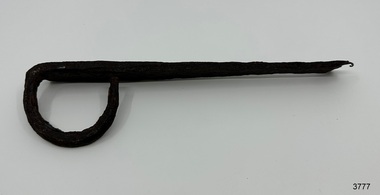
Functional object - Latch, before 1890
In Flagstaff Hill’s collection are items associated with the Ancient Wreck, (also called the Gold Ship, Mahogany Ship or Ancient Vessel). Three relics were located in 1890, due to the ‘interest of a public works inspector, James Gilroy, who dug in the ship’s remains’. One of the relics was a heavily oxidated ‘quantity of ironwork’. The other two, now part of Flagstaff Hill’s collection, are - an iron latch probably from a galley oven door or fireplace - a bronze bolt (spike or pin) Both of these relics are listed on the same page in the records of the Old Warrnambool Museum, found by K.A.G. (or H.A.G.) on the site of the Ancient wreck in 1890. Interestingly, another item in these records is ‘Notes on Ancient wreck, near Gorman’s Lane’. Gorman’s Lane is just inland from the sand dunes of the Coastal Reserve at Tower Hill. The current location of these Notes is unknown. Another item thought to be a relic from the Mahogany Ship was the amphora or jug, also in Flagstaff Hill's collection. It was found in 1934 on a local property and donated in 1985. The Museum opened in 1886 and continued until 1963, when it was closed by the Warrnambool City Council and the whole collection was put into storage. The council then transferred items to various places including Flagstaff Hill and the current Warrnambool Art Gallery. Flagstaff Hill’s early Accession Records book lists the items as being received from the Old Warrnambool Museum collection; the Latch is record 152 and the Pin is record 153. An article, ‘Birthplace of our History’ by Don Dean, is on file in the Warrnambool and District Historical Society. It was published in the Australian POST, on March 17, 1955. This article describes the finding of the items going back to 1890, along with other information about sightings of what has come to be known as the Mahogany Ship. The mystery of the Mahogany Ship began in 1836 when two shipwrecked sealers discovered the remains of an “ancient vessel” in the sand dunes about four miles west of Warrnambool. Since the last recorded sightings in the 1880’s the true origin of the Mahogany Ship has remained one of Australia’s most famous historical mysteries. One of the more recent theories is that the vessel was one of the Portuguese ships exploring the Australian coast in 1522. For over one hundred years searchers have attempted to locate and identify the wreck. The search continues for the tangible evidence which will once and for all establish the Mahogany Ship’s place in Australia’s History. The latch has local historic significance as it was found in the sand dunes of Warrnambool in 1890. The latch is also significant for being part of the original 1886 Warrnambool Museum's collection. The latch is significant for its possible link to one of Victoria’s and Australia’s maritime mysteries, the Mahogany Ship (also known as the Ancient Wreck). It is one of very few known relics that could give evidence of the existence and history of the vessel. It is listed on the Victorian Heritage Register S438 as it is one of Victoria’s oldest recorded shipwrecks. The identity of the vessel has the potential to change Australia’s history.Latch, iron. Flat iron latch tapers inward from loop handle to narrow end with prongs. Handmade. warrnambool, shipwrecked coast, flagstaff hill maritime museum, shipwreck coast, mahogany ship, latch, relic, old warrnambool museum, ancient vessel, ancient wreck, oven latch, fireplace latch, galley oven, gold ship, gorman's lane, coastal reserve, tower hill -
 Flagstaff Hill Maritime Museum and Village
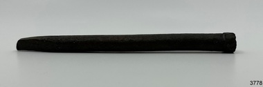
Functional object - Bolt, before 1890
Flagstaff Hill’s collection has items that are thought to be relics from the Ancient Wreck, (also called the Gold Ship, Mahogany Ship or Ancient Vessel). Three relics were located in 1890, due to the ‘interest of a public works inspector, James Gilroy, who dug in the ship’s remains’. One of the relics was a heavily oxidated ‘quantity of ironwork’. The other two, now part of Flagstaff Hill’s collection, are - an iron latch probably from a galley oven door or fireplace - a bronze bolt (spike or pin) Both of these relics are listed on the same page in the records of the Old Warrnambool Museum, found by K.A.G. (or H.A.G.) on the site of the Ancient wreck 1890. Interestingly, another item in these records is ‘Notes on Ancient wreck, near Gorman’s Lane’. Gorman’s Lane is just inland from the sand dunes of the Coastal Reserve at Tower Hill. The current location of these Notes is unknown. Another relic is thought to be the amphora, discovered in 1934 on a local property. The Museum opened in 1886 and continued until 1963, when it was closed by the Warrnambool City Council and the whole collection was put into storage. The council then transferred items to various places including Flagstaff Hill and the current Warrnambool Art Gallery. Flagstaff Hill’s early Accession Records book lists the items as being received from the Old Warrnambool Museum collection; the Latch is record 152 and the Pin is record 153. An article, ‘Birthplace of our History’ by Don Dean, is on file in the Warrnambool and District Historical Society. It was published in the Australian POST, March 17, 1955. This article describes the finding of the items going back to 1890, along with other information about sightings of what has come to be known as the Mahogany Ship. The mystery of the Mahogany Ship began in 1836 when two shipwrecked sealers discovered the remains of an “ancient vessel” in the sand dunes about four miles west of Warrnambool. Since the last recorded sightings in the 1880’s the true origin of the Mahogany Ship has remained one of Australia’s most famous historical mysteries. One of the more recent theories is that the vessel was one of the Portuguese ships exploring the Australian coast in 1522. For over one hundred years searchers have attempted to locate and identify the wreck. The search continues for the tangible evidence which will once and for all establish the Mahogany Ship’s place in Australia’s History. The bolt has local historic significance as it was found in the sand dunes of Warrnambool in 1890. The bolt is also significant for being part of the original 1886 Warrnambool Museum's collection. The bolt is significant for its possible link to one of Victoria’s and Australia’s maritime mysteries, the Mahogany Ship (also known as the Ancient Wreck). It is one of very few known relics that could give evidence of the existence and history of the vessel. It is listed on the Victorian Heritage Register S438 as it is one of Victoria’s oldest recorded shipwrecks. The identity of the vessel has the potential to change Australia’s history.Bolt, also referred to as spike or pin. Bronze bolt, round body with head on one end that has straight sides, tapers to a point at the other end.warrnambool, shipwrecked coast, flagstaff hill maritime museum, shipwreck coast, mahogany ship, relic, pin, spike, old warrnambool museum, nail, ancient vessel, ancient wreck, portuguese ship, gold ship, gorman’s lane, coastal reserve, tower hill -
Glenelg Shire Council Cultural Collection
Book - Collection of reference texts on shells, 1964-2004
Collection of reference texts on seashells. Includes: Dance, Peter S., "Seashells", London: Treasure Press, 1971 (4111.1); "Handy Pocket Guide to Tropical Seashelss of Indonesia, 2004 (4111.2); Dance, Peter S., "Shells", Pymble: Harper Collins, 1992 (4111.3); Linder, Gert, "Seahshells of the world", Sydney: Australia & New Zealand Book Company, 1977 (4111.4); Wilson, B. R. & K. Gillett, "Australian Shells", Sydney: Reed, 1971 (4111.5); Harasewych, M.G., "Shells: Jewels from the Sea", New York: Rizzoli, 1989 (4111.6); "The Golden Stamp Book of Seashells", Wisonsin: Golden Books, 1975 (4111.7); Taylor, John & Jerry G. Walls, "Cowries", Neputune City: T.F.H. Pblications, 1975 (4111.8); Child, John & John Currey, "Shells and the Seashore", Melbourne: Landsdowne Press, 1972 (4111.9); "Sea Shells", London: Orbis Books, 1971 (4111.10); Dance, S. Peter, "Shells and shell collecting", London: Hamlyn, 1972 (4111.11); Clayton, JM, "All colour book of Seashells:, London: Octopus Books, 1974 (4111.12); "Exploring the Secrets of Nature", London: Reader's Digest, 1994 (4111.13); Habe, Tadashige, "Shells of the Western Pacific in colour: Vol I", Osaka: Hoikusha, 1964 (4111.14); Habe, Tadashige, "Shells of the Western Pacific in colour: Vol II", Osaka: Hoikusha, 1964 (4111.15); Dance, Peter S. (ed.), "The Encyclopedia of Shells", Sydney: Australia & New Zealand Book Company, 1977 (4111.16); Hinton, Alan, "Guide to Shells of Papua New Guinea", Port Moseby: Robert Brown and Associates, nd (4111.17); Hinton, Alan, "Guide to Australian Shells", Port Moseby: Robert Brown and Associates, nd (4111.18); "The How and Why wonder book of seashells", New York: Grosset & Dunlap, 1972 (4111.19); Child, J., "Australian Golden Stamp Book: Australian Seashells",Sydney: Golden Press, 1971 (4111.20); Hinton, Alan, "Shells of New Guinea and the Central Indo-Pacific", Port Morsby; Milton: Robert Brown and Associates Pty Ltd; The Jacaranda Press, 1975 (4111.21); Coleman, Neville, "Shells in Australia", Sydney: Reed, 1978 (4111.22); Coleman, Neville, "What Shell is That?", Sydney: Ure Smith Press, 1988 (4111.23); Coleman, Neville, "Shells Alive!", Adelaide: Rigby Publishers, 1981 (4111.24); Deas, Walter, "Seashells of Australia", Adelaide: Rigby Ltd, 1974 (4111.25).maritime, marine ecology, sea shells, reference, natural history -
 Melbourne Tram Museum
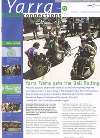
Magazine, Yarra Trams, "Yarra Connections", Dec. 2003
Demonstrates a Yarra Trams staff newsletter..1 - Magazine - 8 pages, full colour, centre stapled, printed on recycled paper, titled "Yarra Connections Issue 12, December 2003", published by Yarra Trams. Notes the launch of the "Wheelchair users guide" for tram passenger, Yarra Trams support for Wheelchair Rugby, planning for Vermont South extension, French award for CEO, Hubert Guyot, photo exhibition featuring employees by Georgia Metaxas, Boroondara residents and Travelsmart, Metlink Team Tigers Basketball, Ikea store in Richmond, pram friendly trams, feedback and return of W class trams to route 30. New track maintenance vehicle -"scrubber truck". .2 - Letter on Yarra Trams letterhead, addressed to Ron Wilson of Orange Grove Bayswater, signed by Paul Matthews Marketing Manager forwarding a copy of the magazine to Ron, noting highlights. Gives address details. .3 - Magazine - as for .1 - issue 1 dated October 1999 with a forward by the CEO Steve Macdonald , Camberwell depot, Deputy CEO Hubert Guyot, new logo designs, reduction in tram stops, tennis trams, family day, Docklands route 70 extension and competition. .4 - magazine - 3 fold A4 - issue 9, dated Nov. 2002, Notes the construction of Route 109, W class, St Vincent's Plaza, Gordon Atkins, Docklands tram services, explorer program, Feedback, Line Officers, Corporate Report and Melbourne Museum tram. .5 - magazine - issue 11 - August 2003 - 8 pages - opening of Box Hill line, Harry the Wombat, trams in the press, Welcome to Dennis Cliche, B class seating trial, Metlink, Docklands, trial information at tram stops (early TramTracker) project and route 75. .6 - magazine issue 13 - April 2004 - Australian Open tram service, Collins and Spencer Superstop, tram services, feedback, Metlink, Channel 10 - The Secret life of us, PTC Cricket Squad. .7 - issue 8 - April 2002 - Grand Prix, Box Hill update, Citadis update, Collins and Spring superstop, Australia Open, Fare Evastion and track joints. 8 - issue 10, undated - Australian Open tennis, Eurotram comes to Melbourne, Docklands joins the City Circle, route 109, Box Hill extension and what is a substation.trams, tramways, yarra trams, w class, disability services, vermont south, awards, metlink, route 30, camberwell depot, docklands, route 70, st vincent's plaza, line officers, box hill, route 109, b class, superstops, cricket, tennis, tramtracker, route 75, city circle -
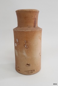 Flagstaff Hill Maritime Museum and Village
Container - Earthenware jar, Bailey & Co, circa 1878
The handmade earthenware jar was one of a group of artefacts in the McCulloch Collection that were recovered from the shipwreck Loch Ard. The jar could have been from the ship's cargo or personal effects. There are other jars in our collection that were recovered from the Loch Ard. The object is now one of the shipwreck artefacts in Flagstaff Hill’s Mc Culloch Collection, which includes items recovered from the wrecks of the Victoria Tower (wrecked in 1869) and Loch Ard (wrecked in 1878). They were salvaged by a diver in the early 1970s from the southwest coast of Victoria. Advanced marine technology had enabled divers to explore the depths of the ocean and gather its treasures before protective legislation was introduced by the Government. The artefacts were donated to Queensland’s Department of Environment and Heritage Protection (EHP) by a passionate shipwreck lover and their locations were verified by Bruce McCulloch. In 2017 the Department repatriated them to Flagstaff Hill where they joined our vast collection of artefacts from Victoria’s Shipwreck Coast. The Loch Ard: - The three-masted, square-rigged iron ship Loch Ard belonged to the famous Loch Line which sailed many ships from England to Australia. The ship was built in Glasgow in 1873. The Loch Ard made three trips to Australia and one trip to Calcutta before its final voyage. The Loch Ard left England on March 2, 1878, under the command of Captain Gibbs, bound for Melbourne with a crew of 37, plus 17 passengers and a load of cargo. The general cargo included straw hats, umbrellas, perfumes, clay pipes, pianos, clocks, confectionery, linen and candles, as well as a heavier load of railway irons, cement, lead and copper. There were items included that were intended for display in the 1880 Melbourne International Exhibition, including the famous Loch Ard Peacock. On June 1, 1878, Captain Gibbs was expecting to see land but visibility was reduced by fog. As it lifted, the sheer cliffs of Victoria's west coast came much closer than expected. The captain was unable to steer away and the ship struck a reef at the base of Mutton Bird Island, near Port Campbell. The top deck was loosened from the hull, the masts and rigging came down and knocked passengers and crew overboard, and even the lifeboat crashed into the side of the ship and capsized. Of the 54 people on board, only two survived: the apprentice, Tom Pearce and the young woman passenger, Eva Carmichael. The well-packed Minton porcelain peacock also survived, safe inside its crate. Much of the cargo was washed up, smashed and broken, and some was salvaged. Other cargo is still with the wreck at the base of Mutton Bird Island, now protected by Government law. The artefact is an example of cargo or personal items on board a ship in 1878. It provides a reference point for classifying and dating similar items. This artefact is significant for its association with the sailing ship Loch Ard, one of the best-known, and one of the worst, shipwrecks in Victoria’s history. Flagstaff Hill’s collection of artefacts from Loch Ard is significant for being one of the largest collections of artefacts from this shipwreck in Victoria. It is significant for its association with the shipwreck, which is on the Victorian Heritage Register (VHR S417). The collection is significant because of the relationship between the objects, as together they have a high potential to interpret the story of the Loch Ard. The Loch Ard collection is archaeologically significant as the remains of a large international passenger and cargo ship. It is historically significant for representing aspects of Victoria’s shipping history. Container, round brown earthenware jar with a wide mouth, thick lip, a wide neck that tapers slightly inwards towards the shoulder, and a body that tapers slightly inward towards the base. The glazed surface is rough. The variegated colours of the clay also has small dark speckles. There are several chips and dents on the jar. The inscription is stamped into the lower edge. Made by Bailey & Co., England. Recovered from the wreck of the Loch Ard.Inscription “Bailey [&] Co / ENGLAND” flagstaff hill, warrnambool, flagstaff hill maritime museum, maritime museum, shipwreck coast, flagstaff hill maritime village, great ocean road, white star line, victorian heritage register, sailing ship loch ard, loch line, loch ard, captain gibbs, eva carmichael, tom pearce, glenample station, mutton bird island, loch ard gorge, migrant ship 1878, cargo ship 1878, stoneware jar, domestic container, kitchenware, kitchen storage, bailey & co england, shipwreck artefact, wreck dive, mcculloch collection, bruce mcculloch, 1878, sailing ship, earthenware, stoneware, domestic jar -
 Flagstaff Hill Maritime Museum and Village
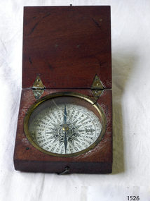
Instrument - Compass, c. 1839
This magnetic compass is a good size to fit easily into a person's pocket or personal luggage and is protected from knocks by its wooden case. It could have been used for reference when travelling on land or sea. There is no visible manufacturer's mark, which may mean that it was not of high monetary value. Leith is a district of Edinburgh in the country of Scotland, the U.K. It was once the Port of Edinburgh and many migrant ships departed from here bound for the Australian colony. It had a busy shipbuilding industry, with wet and dry docks. It appears from the inscription on the case "Chas Gray, LEITH, 1839" that this pocket compass once belonged to Charles M. Gray (Chas is a common abbreviation for the name Charles). The inscription coincides with the name, place and date that the Western Victorian pioneer Charles M. Gray left Scotland and arrived in Australia. Charles Gray was born in Anstruther, Scotland, in 1818. His family was connected with the Royal Marines, which may have created his nautical instruments such as this pocket compass. Charles Gray arrived in Hobson's Bay on 15 June 1839 on the ship “Midlothian”. That same ship had departed from Leith, Scotland on February 15th 1839. Did Charles Gray acquire the pocket compass in Leith, perhaps as a gift or a souvenir of his motherland? Charles Gray was an early squatter and went on to become a very successful settler as a sheep pastoralist in the Western District of what is now Victoria (originally the colony of New South Wales). He and his wife had a large property called “Nareeb Nareeb”, Green Hill Creek District (now Glenthompson), Victoria, from 1840-1886. He was also a local Councillor and Justice of the Peace, and had an interest in the local indigenous people; he named his property after their tribe. Charles returned to England in 1890 and died there in 1905. Charles Gray had written an account in 1890 of his life at Nareeb Nareeb, called Western Victoria in the Forties: "REMINISCENCES OF A PIONEER The Western District in the 1840's By Charles Gray" , a valuable historical reference to colonial Victoria. His book was published by the Hamilton Spectator in 1932. Charles Gray's photograph is one of 713 historical photographs of early Victorian settlers, created as a montage by Thomas Foster Chuck in 1872. The State Library of Victoria holds the framed montage titled “The Explorers and Early Colonists of Victoria”. To qualify for inclusion on this montage the Settlers must have arrived in Victoria before 1843. Charles Gray's photograph is number 349! The pocket compass is associated with Charles Gray, one of the early squatters and settlers in Western Victoria, possibly given to him as a parting gift on his emigration to Van Diemans land in 1839. The item is very significant as it's connection with one of Victoria's early pioneers is well provenanced by the inscriptions on the wooden case. Pocket compass, brass, set into a square wooden case with hinged lid and small hook catch. Compass is marked with 360 degrees and compass points and has two pointers; one to show magnetic north and one to set the direction of travel. Hinges are triangular and inset into the wood. The lid has an attached brass plaque with the inscription "Chas Gray, Leith, 1839" (It likely belonged to Charles Gray, Leith, UK, who migrated to Port Philip Australia in 1839 and became a successful pastoralist.) “Chas Gray / LEITH / 1839” engraved on brass plaque on lid.flagstaff hill, warrnambool, shipwrecked coast, flagstaff hill maritime museum, maritime museum, shipwreck coast, flagstaff hill maritime village, great ocean road, magnetic compass, pocket compass, charles m. gray, chas gray, migrrant from leith 1839, charles gray anstruther, scottland, ship midlothian 1839, squatter western victoria, settler western victoria, hobson's bay port phillip australia, charles gray nareeb nareeb - green hill creek district, western victoria in the forties: reminiscences of a pioneer by charles m. gray 1890, leith edinburgh u.k., western victoria in the forties: reminiscences of a pioneer - montage by thomas foster chuck 1872, charles gray, reminiscences of a pioneer, the western district in the 1840's, compass, scientific instrument, nautical instrument, direction, directional compass, navigation -
 Flagstaff Hill Maritime Museum and Village
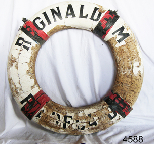
Equipment - Lifebuoy, John Murch, 1922
Lifebuoy is from the ketch Reginald M, built in Port Adelaide by John Murch in 1922. Lifebuoys were part of the emergency lifesaving equipment carried on vessels in the late 19th and early 20th century. The ring was made of strips of cork wood joined together to make the ring shape then covered in canvas and sealed usually with white paint. Four evenly spaced canvas reinforcing bands would be added for strength and for a place to thread a rope or line. A lifebuoy, or life-preserver, is used as a buoyancy device often thrown to an endangered or distressed person in the water to keep them afloat while they receive help. It is usually connected by a rope to a person in a safe area such a nearby vessel or on shore. Lifebuoys is a made from a buoyant materials such as cork or foam and ae usually covered with canvas for protection and to make it easy to grip. The first use of life saving devices in recent centuries was by the Nordic people, who used light weight wood or cork blocks to keep afloat. Cork lifebuoys were used from the late 19th to early 20th century. Kapok fibre was then used as a filling for buoys but wasn’t entirely successful. Light weight balsa wood was used as a filler after WW1. In 1928 Peter Markus invented and patented the first inflatable life-preserver. By WW2 foam was combined with Kapok. Laws were passed over time that has required aeroplanes and water going-vessels to carry life-preservers on board. The Reginald M 1922- The two-masted coastal trading ketch Reginald M was built by John (Jack) Murch in Port Adelaide, South Australia, in 1922 and it was launched there in Largs Bay in the same year. It is thought that the keel was hewn from two telegraph poles - its owner was a regular visitor to salvage yards. Its cargo at times included Guano, Barley, Wool, Horses, Cattle, Timber, Explosives, Potatoes, Shell Grit and Gypsum. At one time the vessel was used as a customs boat, renamed 'HMC No. 3, Pt Adelaide'. In 1969 she was used by a mining and railway company as a barge to carry explosives. In 1972 the vessel was renamed 'T.S. Macquarie' and planned to be used for sea cadet training.; this did not eventuate. It was sold again and went to Melbourne to be used for pleasure sailing, and again sold for use as a ferry. Late in 1975 Flagstaff Hill purchased the vessel to be used as an exhibit at the Maritime Village where many visitors enjoyed being able to board and explore a real ship with a long history. Sadly, in late 2016, the decision was made to 'decommission' the vessel due to the continuing high cost of maintenance and the risk to public safety. Many of the components of the vessel are held as part of Flagstaff Hill's collection.The lifebuoy is an example of equipment carried on vessels in the late 19th and early 20th century to help preserve life. There were many lives lost in Australia’s colonial period, particularly along the coast of South West Victoria. The lifebuoy is significant for its connection with the Australian built, 1922 coastal trader, Reginald M. Lifebuoy, round , cork, filled, white canvas cover with four red tabs. Text is printed in black on quarters 1 and 3. This lifebuoy once belonged to the vessel 'Reginald M' , Pt Adelaide. "REGINALD M / Pt ADELAIDE".flagstaff hill, warrnambool, shipwrecked-coast, flagstaff-hill, flagstaff-hill-maritime-museum, maritime-museum, shipwreck-coast, flagstaff-hill-maritime-village, lifebuoy, lifesaving, ship equipment, reginald m, life rings, safety ring, life-saving buoy, ring buoy, life preserver, personal floating device, floatation device, safety equipment, coastal trader, john murch, reg webb -
 Flagstaff Hill Maritime Museum and Village
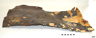
Functional object - Copper Sheathing, Ca. 1855
This sheet of copper sheathing or Muntz metal has been recovered from the site of the wrecked ship Schomberg. It has been damaged by the reaction of the metals to the sea, it has encrustations from the sea such as sand, and another damage has caused the edges to break away or fold over. Early sailing ships had a problem of the timber hulls being eaten through by the marine animals called Teredo Worms, sometimes called ‘sea worms’ or ‘termites of the sea’. The worms bore holes into wood that is immersed in seawater and the bacteria inside the worms digest the wood. Early shipbuilders applied coatings of tar, was, lead or pitch onto the timber to prevent this. In the 18th and 19th centuries, the outsides of ships’ hulls were encased in either copper sheathing or Muntz metal, which is a combination of 60 per cent copper and 40 per cent zinc. The ships would be re-metalled periodically to ensure the sheathing would remain effective. In more recent times the ships are protected with a toxic coating. About the SCHOMBERG- James Blaine’s Black Ball Line had commissioned the luxury sailing ship, Schomberg, to be built for its fleet of passenger liners The three-masted wooden ship was launched in 1855, designed by the Aberdeen builders to sail faster than the quick clippers designed by North American Donald McKay. The material used for the diagonal planking was British oak with layers of Scottish larch. The Schomberg’s master Captain ‘Bully’ Forbes commanded the ship on its maiden journey between Liverpool and Melbourne, departing on 6 October 1855 with 430 passengers and 3000 tons of cargo including iron rails and equipment intended the build the Geelong Railway and a bridge over the Yarra from Melbourne to Hawthorn. After sailing for 78 days she ran aground on a sand spit at Curdies Inlet near Peterborough, Victoria, on 27 December 1835. At dawn on the next day, the ship’s Chief Officer signalled a passing steamer, SS Queen, for help and all of Schomberg’s passengers were able to disembark safely. The passengers’ baggage and some of the cargo were later collected from the Schomberg. Local merchants Manifold & Bostock bought the wreck and the remaining cargo but did not attempt to salvage the cargo that was still on board. They eventually sold it and after two of the men drowned in the salvage efforts the job was abandoned. In 1975, divers from Flagstaff Hill, including former Director, Peter Ronald, explored the Schomberg wreck site and recovered many artefacts that are now on display at the Museum.The copper sheathing is significant for its connection with the Schomberg, which is on the Victorian Heritage Register (VHR S612), has great historical significance as a rare example of a large and fast clipper ship that sailed on the England-to-Australia run, carrying emigrants at the time of the Victorian gold rush. She represents the technical advances made to break sailing records between Europe and Australia. Flagstaff Hill’s collection of artefacts from the Schomberg is significant for its association with the shipwreck. The collection is primarily significant because of the relationship between the objects, as together they can interpret the story of the ship, Schomberg. It is archaeologically significant as the remains of an international passenger Ship. It is historically significant for representing aspects of Victoria’s shipping history and for its association with the shipwreck and the ship, which was designed to be the fastest and most luxurious of its day.Copper sheathing; rectangular sheet of copper, shaped for use on a ship's hull, buckled, with fibres protruding from one edge. The object was recovered from the wreck of the SCHOMBERG.flagstaff hill, warrnambool, maritime village, maritime museum, shipwreck coast, great ocean road, schomberg, clipper ship, black ball line, 1855 shipwreck, aberdeen clipper ship, captain forbes, peterborough shipwreck, ss queen, ship construction, copper sheating, sheathing, sea worm, muntz, muntz metal, copper sheathing, teredo worms, sea worms, sea termites, shipbuilding -
 Federation University Art Collection
Painting, Norman Hofmaier, 'Promethius 1 from the Mallee Mysteries Series', by Norman Hofmaier
Norman Keith HOFMAIER (12.08.1951- ) Born Beulah, Wimmera, Victoria Norman Hofmaier was a scion of a well-known family, he completed his secondary education at Hopetoun High School and Ballarat College. Later he studied Visual Art at University of Ballarat, including painting, design and sculpture. Hofmaier’s childhood in Beulah was spent on the family property running beside the Yarriambiack Creek. Both he and his father had an intimate knowledge of the flora and fauna of the Mallee. The Wyperfeld National Park, home to the Big Desert, was a favourite place for Norman’s uncle who planted acres of native trees at the family property. Dr Di Bresciani explains: “The colours and vastness of the Mallee are represented in many works which reflect, variously, the relentless quiet and swirling energies found in the ‘dust storm might’ of the Mallee area. Most works may be described as abstract, lyrical abstract or abstract expressionist." From the 1970s until the 1990s he began an outpouring of work, using oil-based paints overlaid manually on large, specially-prepared boards using brushes, cloths, sponges, sprays or rollers. Petrol solvents were used to soften, blur and enhance shapes and edges. His work reflected his exploration of his inner state, sometimes flowing and placid, sometimes tempestuous. After a brief sojourn into city-life Norman returned to working in the country, until finally submitting to mental illness and permanent care in the mid 1990s. Norman Hofmaier's works are represented in major collections including that of the well- known artist Mitch Pearson ( an important influence and lifelong friend). The work 'Pastel of a Nude' was shown in a widely distributed magazine and two works owned by Mark Shannon were planned to be published as record covers in 1993. He won an award during the bicentennial recognising his skill as a Wimmera artist. From the 1970s until the 1990s he began an outpouring of work, using oil-based paints overlaid manually on large, specially-prepared boards using brushes, cloths, sponges, sprays or rollers. Petrol solvents were used to soften, blur and enhance shapes and edges. This work was purchased from the exhibition 'Norman Hofmaier: Mallee Mysteries' at the Lost Ones Gallery in Camp Street, Ballarat. The exhibition explored the legacy of Hofmaier’s work as well as raising money for the Ballarat Art Foundation. The Hofmaier family donated 16 works of the artist to be sold to raise funds for the foundation, to support emerging artists.Original painting in square format, featuring abstract swirls of blue, white, red, yellow and green.On back of work: 1. pools of diluted oil paint covering approximately 8 cm from each edge, 2. in right hand corner in permanent marker "N Hofmaier" 3. middle right hand side, torn exhibition label, with the words, "Belauh", "Local Art", "Prome", "Local Art", "$350", "Collect A", "oin" 4. Bottom right corner, two exhibition labels on card. Cards read: The flowing of movement before any known bodies are formed. Matter and gases bubble forming kaleidoscopic colours and shapes. Promethius 1 Oil based pigment with petrol on prepared board 1320 x 1210 mm On front of work, bottom right hand corner, in white lettering, N Hofmaier. Bottom right hand olive green frame damaged on front of work.painter, mallee, beluah, norman hofmaier, wimmera, abstract, alumni -
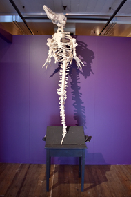 National Wool Museum
Sculpture - The Wreck of Hope, Michele Beevors, 2014
The Wreck of Hope (Long-nosed Common Dolphin skeleton, Delphinus delphis) featured as part of the exhibition Anatomy Lessons, shown at the National Wool Museum in 2024. The exhibition featured meticulously-sculpted, life size skeletons, making visitors question their place in this web of the living and the dead. From a towering giraffe stretching 4.4 metres in height, to an army of over 50 delicately rendered frogs, this exhibition was enthralling in scale. Each sculpture is an accurate portrayal of a real animal and is carefully measured, drawn, and moulded from steel, wire, and foam. The frame is then intricately knitted over to create these thought-provoking pieces. Each sculpture tells a story, one of the collection of animals by museums and collectors, of Western safari hunters, of human encroachment, and of the often-sad role of the animals in our lives. These underlying concepts are explored and reflected by the materials used. Wool, that speaks of warmth, of comfort, of care, meets the size, grace, and sheer breathtaking beauty of the pieces, clashing with the hard and complex stories beneath. This knitted dolphin skeleton was the start of Beevor's interest in comparative anatomy. Beevors recalls viewing a dolphin, one of many skeletons alongside a mouse and a lion in the Australian Museum's collection during a school visit in the 1970s. At the time, school children watched TV reruns of 'Flipper', which portrayed dolphins as intelligent and noble animals. Elsewhere, the conservation movement was growing, and appeals to protect marine mammals were gaining momentum through the 'Save the Whales' campaign. The fascination with live dolphin shows had grown throughout the 1960s and 1970s and the ethics began to be questioned. Some believe they played an important role in raising public awareness of cetaceans and their welfare. Others argued the performances glorified the dominance of heroic trainers over the subordinate dolphin, and offered little education about the dolphins' natural characteristics nor prioritised their welfare. Many of these facilities are now closed and all dolphin species are protected by international accords aimed at conserving wild populations. Despite this dolphins are still at risk of swallowing plastic waste, mercury toxicity, toxoplasmosis, boat impacts and being bycatch in commercial fishing operations. Originally from Australia, Michele Beevors has been practicing in New Zealand for the last 20 years. She is Head of Sculpture at Dunedin School of Art, Otago Polytechnic, New Zealand’s oldest, and one of its most prestigious, art schools. Beevors has exhibited in galleries, museums, and exhibition spaces in across New Zealand, Australia and Vienna with art that is defiant, unconventional, and moving.Life sized knitted skeleton of a dolphin, with white wool and internal steel, foam and wire frame. The dolphin is mounted on a wooden base, made from a desk, with books placed under the desk lid. The books and desk are painted black.knitting, art, dolphin, conservation, sculpture, skeletons, anatomy lessons, michele beevors -
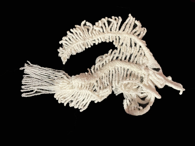 National Wool Museum
Sculpture - Angel, Michele Beevors, 2016
Angel featured as part of the exhibition Anatomy Lessons, shown at the National Wool Museum in 2024. The exhibition featured meticulously-sculpted, life size skeletons, making visitors question their place in this web of the living and the dead. From a towering giraffe stretching 4.4 metres in height, to an army of over 50 delicately rendered frogs, this exhibition was enthralling in scale. Each sculpture is an accurate portrayal of a real animal and is carefully measured, drawn, and moulded from steel, wire, and foam. The frame is then intricately knitted over to create these thought-provoking pieces. Each sculpture tells a story, one of the collection of animals by museums and collectors, of Western safari hunters, of human encroachment, and of the often-sad role of the animals in our lives. These underlying concepts are explored and reflected by the materials used. Wool, that speaks of warmth, of comfort, of care, meets the size, grace, and sheer breathtaking beauty of the pieces, clashing with the hard and complex stories beneath. The smallest of Beevors’ knitted pieces was made while reflecting on the global tropical fish trade. At the time, press reports predicted that the imminent release of the film ‘Finding Dory’ would increase demand for pet tropical fish. People enjoy a good fish story, but studies have revealed that widespread reports of the ‘Nemo Effect’ following the debut of the film’s predecessor, ‘Finding Nemo’, were exaggerated. Data collected to assess people’s interest in blue tang, the species of the title character in ‘Finding Dory’, revealed an increase in online searches for “blue tang”, but no evidence of an increase in their trade or visits to public aquariums to observe them. When discussing the action and attitude effects of pop culture depictions of animals, it is necessary to investigate evidence-based material. Pop culture, wildlife documentaries, web videos, blogs, and news stories: there is a great ocean of content to consume, but the mechanisms by which witnessing these representations of animals and nature leads to tangible behaviour change, positive or bad, individual and social, remains poorly understood. In a world inundated with messaging and content, could a simple phrase like “fish are friends, not food” influence attitudes? Originally from Australia, Michele Beevors has been practicing in New Zealand for the last 20 years. She is Head of Sculpture at Dunedin School of Art, Otago Polytechnic, New Zealand’s oldest, and one of its most prestigious, art schools. Beevors has exhibited in galleries, museums, and exhibition spaces in across New Zealand, Australia and Vienna with art that is defiant, unconventional, and moving.Knitted white woollen fish skeleton, with black pupil.knitting, art, conservation, sculpture, skeletons, anatomy lessons, michele beevors, fish, angel fish -
 Eltham District Historical Society Inc
Photograph, Hume and Hovell passed here at Seymour 28 Oct 1824, Spring Excursion, Hume and Hovell's 1824 expedition (Part 2), 26 October 1997, 26/10/1997
[article by Diana Bassett-Smith in EDHS Newsletter No. 117, November 1997:] MONUMENT HUNTING THE HUME AND HOVELL WAY - Sunday October 26 1997 dawned bright and very warm. Some twenty-five members, complete with picnic baskets, met outside the Eltham Library awaiting the Cobb and Co. large coach which would be taking us on the second leg of our travels along the route of the early explorers Hume and Hovell. Stephen West was our very good driver for the day. He would be guided around the circuitous route by Russell Yeoman who had made a detailed study, not only of the intended route, but of the story of these two explorers. During the trip Russell regaled us with poetry, quotations from the Journals and the History of the Shire of Seymour, "The New Crossing Place" by Martindale, 1982, (now Mitchell Shire due to the recent amalgamations). We headed towards the Hume Highway via Greensborough and Cooper Street and proceeded north to our first stop, noting on the way Monument Hill in the distance which is near Kilmore and, according to Russell, well worth the effort to visit as the view across the valley is magnificent. Past Sunday Creek Valley, Mt Piper and Mt Disappointment, all traversed and noted and named by them. We passed through Tallarook, then onto Seymour where we took photos of the monument telling us that Hume and Hovell had passed through on the 28th of October 1824. We also deviated down Hume and Hovell Road viewing deer and emu farming and the Bellbourie property now a sanctuary. Leaving Seymour behind we travelled up the Avenel Road to the Avenel monument, pyramidal in design of four reducing square blocks with a sharply pointed peak, erected in 1924 in memory of the 1824 exploration. The day was warming up and the countryside showing the dryness of the current drought. A parallel note had been made in their journal too of 1824 of the drought appearance of the country they were traversing. At Seven Creeks, Euroa we stopped for some minutes to check the monument placed 20th November 1924 to commemorate their passage on the 29th December 1824. More photos. Russell had pointed out the abrupt termination of the distant ranges which is noted in their journal. The next monument is beside the road at the entrance to Honey Suckle Creek Caravan Park, Violet Town. The squarish shaped monument some eight feet high is topped with a simple steel cross, and was to mark the date of 28th December 1824 and built for the 20th November 1924. By now it was 12.20 and nearly lunchtime as we drove along the Warranbayne Road to Roach's Road, monument hunting without success. Though there is a large, what appears to be an old timber sign which was hard to read, maybe this was the lost monument. In many of the paddocks hay had been cut and baled or was being cut, what a contrast to the rugged country they had passed through which was smoky from the fires of the natives burning off. By 1.00 pm we were at Benalla and pulled up beside the park where abundant beds of roses filled the air with their scent and the smell of barbecued food twitched the nostrils whilst the cheerful sounds of other picnickers could be heard throughout the park. We left the bus and collected up our picnics, dispersed to the various tables and enjoyed the shade from the various European trees. 2.00 pm and we were on the road again driving along the Benalla, Mansfield, Yea road. The Swanpool monument states that they passed four miles south and returned three miles north. Then we stopped at the Barjarg monument which notes that they camped near this spot. It is again a pyramidal monument and this time topped with a steel arrow indicating their route of the 29th November 1824. Half an hour later we came to another monument, again with a steel arrow marker on top and the plaque dated the 2nd of 12th 1824. Erected on the 12th of 12th 1924. "They blazed the way that we might inherit the land." Another square based and needle topped monument appeared at Yarck near Yea and this plaque records the date of 3 December 1824. Near McGuigans Road Russell related that the expedition had lost a dog but it had found them next day, the dog was apparently torn by a kangaroo. A short while later Russell reminded us here of the problems they encountered in crossing the Goulburn River near Molesworth where banks were high, water deep and wide. "Good coat of grass but quite dry due to drought". At Yea we stopped for afternoon tea and raided the last of our picnics and looked at the monument to their journey of 1824, situated at a corner of the gardens near the bowling green. No photo – we were out of film. We returned home via Kinglake West and Whittlesea past the Yan Yean Reservoir, not full. 5.00 pm back at Eltham we emptied out of the bus and everyone, including Joan Cole, collected their things, Joan also had the major souvenir of the day, a large carp she had picked up from the river bank, her cat was in for a great feast. The day was made so interesting by the informed commentary which Russell provided. His background knowledge of the route and nature of the journey could only have come from many hours of reading and driving the area. Thank you to Russell and to everyone who made the day so informative and pleasurable. Colour photographactivities, hume and hovell, monument, seymour -
 Eltham District Historical Society Inc
Photograph, Spring Excursion, Hume and Hovell's 1824 expedition (Part 2), 26 October 1997, 26/10/1997
[article by Diana Bassett-Smith in EDHS Newsletter No. 117, November 1997:] MONUMENT HUNTING THE HUME AND HOVELL WAY - Sunday October 26 1997 dawned bright and very warm. Some twenty-five members, complete with picnic baskets, met outside the Eltham Library awaiting the Cobb and Co. large coach which would be taking us on the second leg of our travels along the route of the early explorers Hume and Hovell. Stephen West was our very good driver for the day. He would be guided around the circuitous route by Russell Yeoman who had made a detailed study, not only of the intended route, but of the story of these two explorers. During the trip Russell regaled us with poetry, quotations from the Journals and the History of the Shire of Seymour, "The New Crossing Place" by Martindale, 1982, (now Mitchell Shire due to the recent amalgamations). We headed towards the Hume Highway via Greensborough and Cooper Street and proceeded north to our first stop, noting on the way Monument Hill in the distance which is near Kilmore and, according to Russell, well worth the effort to visit as the view across the valley is magnificent. Past Sunday Creek Valley, Mt Piper and Mt Disappointment, all traversed and noted and named by them. We passed through Tallarook, then onto Seymour where we took photos of the monument telling us that Hume and Hovell had passed through on the 28th of October 1824. We also deviated down Hume and Hovell Road viewing deer and emu farming and the Bellbourie property now a sanctuary. Leaving Seymour behind we travelled up the Avenel Road to the Avenel monument, pyramidal in design of four reducing square blocks with a sharply pointed peak, erected in 1924 in memory of the 1824 exploration. The day was warming up and the countryside showing the dryness of the current drought. A parallel note had been made in their journal too of 1824 of the drought appearance of the country they were traversing. At Seven Creeks, Euroa we stopped for some minutes to check the monument placed 20th November 1924 to commemorate their passage on the 29th December 1824. More photos. Russell had pointed out the abrupt termination of the distant ranges which is noted in their journal. The next monument is beside the road at the entrance to Honey Suckle Creek Caravan Park, Violet Town. The squarish shaped monument some eight feet high is topped with a simple steel cross, and was to mark the date of 28th December 1824 and built for the 20th November 1924. By now it was 12.20 and nearly lunchtime as we drove along the Warranbayne Road to Roach's Road, monument hunting without success. Though there is a large, what appears to be an old timber sign which was hard to read, maybe this was the lost monument. In many of the paddocks hay had been cut and baled or was being cut, what a contrast to the rugged country they had passed through which was smoky from the fires of the natives burning off. By 1.00 pm we were at Benalla and pulled up beside the park where abundant beds of roses filled the air with their scent and the smell of barbecued food twitched the nostrils whilst the cheerful sounds of other picnickers could be heard throughout the park. We left the bus and collected up our picnics, dispersed to the various tables and enjoyed the shade from the various European trees. 2.00 pm and we were on the road again driving along the Benalla, Mansfield, Yea road. The Swanpool monument states that they passed four miles south and returned three miles north. Then we stopped at the Barjarg monument which notes that they camped near this spot. It is again a pyramidal monument and this time topped with a steel arrow indicating their route of the 29th November 1824. Half an hour later we came to another monument, again with a steel arrow marker on top and the plaque dated the 2nd of 12th 1824. Erected on the 12th of 12th 1924. "They blazed the way that we might inherit the land." Another square based and needle topped monument appeared at Yarck near Yea and this plaque records the date of 3 December 1824. Near McGuigans Road Russell related that the expedition had lost a dog but it had found them next day, the dog was apparently torn by a kangaroo. A short while later Russell reminded us here of the problems they encountered in crossing the Goulburn River near Molesworth where banks were high, water deep and wide. "Good coat of grass but quite dry due to drought". At Yea we stopped for afternoon tea and raided the last of our picnics and looked at the monument to their journey of 1824, situated at a corner of the gardens near the bowling green. No photo – we were out of film. We returned home via Kinglake West and Whittlesea past the Yan Yean Reservoir, not full. 5.00 pm back at Eltham we emptied out of the bus and everyone, including Joan Cole, collected their things, Joan also had the major souvenir of the day, a large carp she had picked up from the river bank, her cat was in for a great feast. The day was made so interesting by the informed commentary which Russell provided. His background knowledge of the route and nature of the journey could only have come from many hours of reading and driving the area. Thank you to Russell and to everyone who made the day so informative and pleasurable. Colour photographactivities, hume and hovell, bridge -
 Eltham District Historical Society Inc
Photograph, Spring Excursion, Hume and Hovell bus tour Stage 2, Seymour, Benalla; 26 Oct 1997, 26/10/1997
MONUMENT HUNTING THE HUME AND HOVELL WAY (Newsletter No. 117, November 1997, by Diana Bassett-Smith) Sunday October 26 1997 dawned bright and very warm. Some twenty-five members, complete with picnic baskets, met outside the Eltham Library awaiting the Cobb and Co. large coach which would be taking us on the second leg of our travels along the route of the early explorers Hume and Hovell. Stephen West was our very good driver for the day. He would be guided around the circuitous route by Russell Yeoman wh9 had made a detailed study, not only of the intended route, but of the story of these two explorers. During the trip Russell regaled us with poetry, quotations from the Journals and the History of the Shire of Seymour, "The New Crossing Place: by Martindale, 1982, (now Mitchell Shire due to the recent amalgamations). We headed towards the Hume Highway via Greensborough and Cooper Street and proceeded north to our first stop, noting on the way Monument Hill in the distance which is near Kilmore and, according to Russell, well worth the effort to visit as the view across the valley is magnificent. Past Sunday Creek Valley, Mt Piper and Mt Disappointment, all traversed and noted and named by them. We passed through Tallarook, then onto Seymour where we took photos of the monument telling us that Hume and Hovell had passed through on the 28th of October 1824. We also deviated down Hume and Hovell Road viewing deer and emu farming and the Bellbourie property now a sanctuary. Leaving Seymour behind we travelled up the Avenel Road to the Avenel monument, pyramidal in design of four reducing square blocks with a sharply pointed peak, erected in 1924 in memory of the 1824 exploration. The day was warming up and the countryside showing the dryness of the current drought. A parallel note had been made in their journal too of 1824 of the drought appearance of the country they were traversing. At Seven Creeks, Euroa we stopped for some minutes to check the monument placed 20th November 1924 to commemorate their passage on the 29th December 1824. More photos. Russell had pointed out the abrupt termination of the distant ranges which is noted in their journal. The next monument is beside the road at the entrance to Honey Suckle Creek Caravan Park, Violet Town. The squarish shaped monument some eight feet high is topped with a simple steel cross, and was to mark the date of 28th December 1824 and built for the 20th November 1924. By now it was 12.20 and nearly lunchtime as we drove along the Warranbayne Road to Roach's Road, monument hunting without success. Though there is a large, what appears to be an old timber sign which was hard to read, maybe this was the lost monument. In many of the paddocks hay had been cut and baled or was being cut, what a contrast to the rugged country they had passed through which was smoky from the fires of the natives burning off By 1.00 pm we were at Benalla and pulled up beside the park where abundant beds of roses filled the air with their scent and the smell of barbecued food twitched the nostrils whilst the cheerful sounds of other picnickers could be heard throughout the park. We left the bus and collected up our picnics, dispersed to the various tables and enjoyed the shade from the various European trees. 2.00 pm and we were on the road again driving along the Benalla, Mansfield, Yea road. The Swanpool monument states that they passed four miles south and returned three miles north. Then we stopped at the Barjarg monument which notes that they camped near this spot. It is again a pyramidal monument and this time topped with a steel arrow indicating their route of the 29th November 1824. Half an hour later we came to another monument, again with a steel arrow marker on top and the plaque dated the 2nd of 12th 1824. Erected on the 12th of 12th 1924. "They blazed the way that we might inherit the land." Another square based and needle topped monument appeared at Yarck near Yea and this plaque records the date of 3 December 1824. Near McGuigans Road Russell related that the expedition had lost a dog but it had found them next day, the dog was apparently torn by a kangaroo. A short while later Russell reminded us here of the problems they encountered in crossing the Goulburn River near Molesworth where banks were high, water deep and wide. "Good coat of grass but quite dry due to drought". At Yea we stopped for afternoon tea and raided the last of our picnics and looked at the monument to their journey of 1824, situated at a corner of the gardens near the bowling green. No photo – we were out of film. We returned home via Kinglake West and Whittlesea past the Yan Yean Reservoir, not full. 5.00 pm back at Eltham we emptied out of the bus and everyone, including Joan Cole, collected their things, Joan also had the major souvenir of the day, a large carp she had picked up from the river bank, her cat was in for a great feast. The day was made so interesting by the informed commentary which Russell provided. His background knowledge of the route and nature of the journey could only have come from many hours of reading and driving the area. Thank you to Russell and to everyone who made the day so informative and pleasurable. Diana Bassett-Smith. Record of the Society's history of activities - Spring 1997 excursionRoll of 35mm colour negative film, 6 stripsFuji 200shire of eltham historical society, activities, pretty hill, seymour, benalla, hume and hovell, monuments -
 Eltham District Historical Society Inc
Photograph, Spring Excursion, Hume and Hovell bus tour Stage 2, Seymour, Benalla; 26 Oct 1997, 26/10/1997
MONUMENT HUNTING THE HUME AND HOVELL WAY (Newsletter No. 117, November 1997, by Diana Bassett-Smith) Sunday October 26 1997 dawned bright and very warm. Some twenty-five members, complete with picnic baskets, met outside the Eltham Library awaiting the Cobb and Co. large coach which would be taking us on the second leg of our travels along the route of the early explorers Hume and Hovell. Stephen West was our very good driver for the day. He would be guided around the circuitous route by Russell Yeoman wh9 had made a detailed study, not only of the intended route, but of the story of these two explorers. During the trip Russell regaled us with poetry, quotations from the Journals and the History of the Shire of Seymour, "The New Crossing Place: by Martindale, 1982, (now Mitchell Shire due to the recent amalgamations). We headed towards the Hume Highway via Greensborough and Cooper Street and proceeded north to our first stop, noting on the way Monument Hill in the distance which is near Kilmore and, according to Russell, well worth the effort to visit as the view across the valley is magnificent. Past Sunday Creek Valley, Mt Piper and Mt Disappointment, all traversed and noted and named by them. We passed through Tallarook, then onto Seymour where we took photos of the monument telling us that Hume and Hovell had passed through on the 28th of October 1824. We also deviated down Hume and Hovell Road viewing deer and emu farming and the Bellbourie property now a sanctuary. Leaving Seymour behind we travelled up the Avenel Road to the Avenel monument, pyramidal in design of four reducing square blocks with a sharply pointed peak, erected in 1924 in memory of the 1824 exploration. The day was warming up and the countryside showing the dryness of the current drought. A parallel note had been made in their journal too of 1824 of the drought appearance of the country they were traversing. At Seven Creeks, Euroa we stopped for some minutes to check the monument placed 20th November 1924 to commemorate their passage on the 29th December 1824. More photos. Russell had pointed out the abrupt termination of the distant ranges which is noted in their journal. The next monument is beside the road at the entrance to Honey Suckle Creek Caravan Park, Violet Town. The squarish shaped monument some eight feet high is topped with a simple steel cross, and was to mark the date of 28th December 1824 and built for the 20th November 1924. By now it was 12.20 and nearly lunchtime as we drove along the Warranbayne Road to Roach's Road, monument hunting without success. Though there is a large, what appears to be an old timber sign which was hard to read, maybe this was the lost monument. In many of the paddocks hay had been cut and baled or was being cut, what a contrast to the rugged country they had passed through which was smoky from the fires of the natives burning off By 1.00 pm we were at Benalla and pulled up beside the park where abundant beds of roses filled the air with their scent and the smell of barbecued food twitched the nostrils whilst the cheerful sounds of other picnickers could be heard throughout the park. We left the bus and collected up our picnics, dispersed to the various tables and enjoyed the shade from the various European trees. 2.00 pm and we were on the road again driving along the Benalla, Mansfield, Yea road. The Swanpool monument states that they passed four miles south and returned three miles north. Then we stopped at the Barjarg monument which notes that they camped near this spot. It is again a pyramidal monument and this time topped with a steel arrow indicating their route of the 29th November 1824. Half an hour later we came to another monument, again with a steel arrow marker on top and the plaque dated the 2nd of 12th 1824. Erected on the 12th of 12th 1924. "They blazed the way that we might inherit the land." Another square based and needle topped monument appeared at Yarck near Yea and this plaque records the date of 3 December 1824. Near McGuigans Road Russell related that the expedition had lost a dog but it had found them next day, the dog was apparently torn by a kangaroo. A short while later Russell reminded us here of the problems they encountered in crossing the Goulburn River near Molesworth where banks were high, water deep and wide. "Good coat of grass but quite dry due to drought". At Yea we stopped for afternoon tea and raided the last of our picnics and looked at the monument to their journey of 1824, situated at a corner of the gardens near the bowling green. No photo – we were out of film. We returned home via Kinglake West and Whittlesea past the Yan Yean Reservoir, not full. 5.00 pm back at Eltham we emptied out of the bus and everyone, including Joan Cole, collected their things, Joan also had the major souvenir of the day, a large carp she had picked up from the river bank, her cat was in for a great feast. The day was made so interesting by the informed commentary which Russell provided. His background knowledge of the route and nature of the journey could only have come from many hours of reading and driving the area. Thank you to Russell and to everyone who made the day so informative and pleasurable. Diana Bassett-Smith. Record of the Society's history of activities - Spring 1997 excursionRoll of 35mm colour negative film, 6 stripsFuji 200shire of eltham historical society, activities, pretty hill, seymour, benalla, hume and hovell, monuments