Showing 21643 items matching "high-jump"
-
 Stawell Historical Society Inc
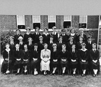
Photograph, Stawell High School Form 3A -- Named 1955
Stawell High School Students 1955stawell education -
 Stawell Historical Society Inc
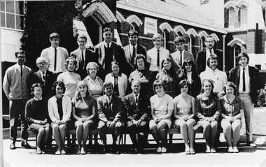
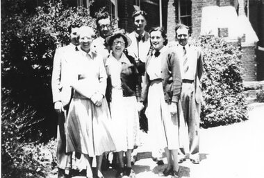
Photograph, Stawell High School Staff -- Named 1969
Stawell High School Staff 1969stawell education -
 Stawell Historical Society Inc
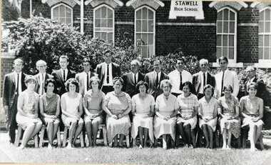
Photograph, Stawell High School Staff -- Named 1966
Stawell High School - Staff 1966stawell education -
 Stawell Historical Society Inc
Photograph, Stawell High School Form 5A 1978 -- Coloured
School - Stawell High School 1978stawell education -
Stawell Historical Society Inc
Photograph, Stawell High School Year 12 -- Named 1979 -- Coloured
School - Stawell High School 1979stawell education -
 Stawell Historical Society Inc
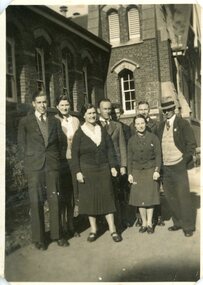
Photograph, Stawell High School Staff -- Named 1938
Stawell High School Staff 1938stawell education -
 Stawell Historical Society Inc
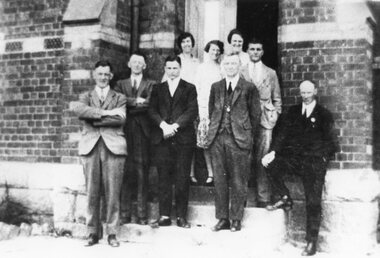
Photograph, Stawell High School Prefects -- Named 1928
Stawell High School Prefects 1928stawell education -
 Stawell Historical Society Inc
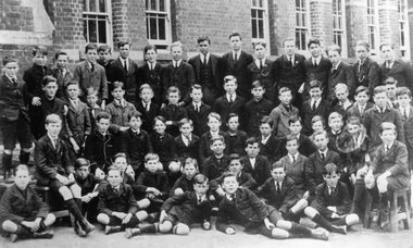
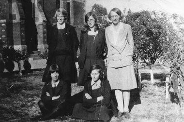
Photograph, Stawell High School Students -- Named 1923
Stawell High School Students 1923stawell education -
Stawell Historical Society Inc
Photograph, Stawell High School Form 4A -- Named
Stawell High School Form 4Astawell education -
 Kiewa Valley Historical Society
Photographs and copies of photographs of the pack horses and early horsemen who transported supplies to outposts in the Bogong High Plains, via cattle tracks before access roads were made
In the mid to late 1930’s survey outposts were established to plot the early stages of the Kiewa Hydro Electric System for the SECV in the Bogong High Plains. Before any roads were built, the old cattleman’s tracks were used with packhorses to deliver supplies, wages and mail and collect timesheets and correspondence from the workmen and dam builders living in canvas tents and at the outlying survey posts. The trip up the mountain was long and hard and dangerous for both horse and man Most of the men of the survey teams were not bush-men and were often ill equipped for the harsh weather and living conditions of bush camping, often arriving in their city clothes ready for work. The tent city at Bogong was destroyed by bush fires in 1939 after which an access road was built from Mt Beauty to transport building materials for more permanent dwellings for workmen. Pack horses continued to be used for transporting goods etc. to workers further up the mountain.Without the work of horsemen and their pack horses providing supplies and communications for outlying outposts, surveying and early planning for the Kiewa Valley Hydro Electric scheme could not have gone ahead and the dams and power stations which support the system could not have been constructed. The Hydro-electric scheme, and the workers who planned and built it play a major part in the early history of the Kiewa Valley and many original families still remain living, or have ties with the local area.: Set of 21 black and white photographs and copies of photographs depicting the pack horses and the men who handled them, transporting supplies and correspondence to the outlying camps and survey posts in the Bogong High Plains, via the rough cattlemen’s tracks. Photographs also show the early tent camps of the workers. Some photos mounted on A4 white paper. Some photos enlarged to A3 poster size for display1. Handwritten on back – Max Lawrence 2. -8 No inscriptions 9. Handwritten on back- Packing in supplies for early workers of the Kiewa Hydro scheme. There were no roads in the early days of the scheme 10. Printed on bottom of photo- Roper’s cattle on road below Howman’s Gap 11. Handwritten on back – Roper’s et al about to leave for the high plains 12. Printed under photo- Syd Ryder at the Pretty Valley Cut-Out (JBR) 13-16. No markings 17. Printed under photo- Gwen Talbot visits the Camp area. 1937 18. Handwritten on back- 14/1 Barbara Talbot 19. No markings 20-21. No markings 22. Printed under photo- STATE ELECTRICITY COMMISSION OF VICTORIA. Date: 15-3-45 Time: 8.0pm No: K 1838 Kiewa Hydro-Electric Works, Investigations 1944-1945 – Survey Camp at Young’s Hut pack horses; bogong high plains; survey posts; supplies delivery -
 Lakes Entrance Historical Society
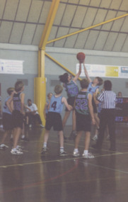
Photograph - Ross Davis and Xavier Ellis, Lakes Post Newspaper, 1999c
fBoys Under 14 team in action during finals Ross Davis playing Xavier Ellis in a jump ball Lakes Entrance VictoriaColour photograph of Boys Under 14 team in action during finals Ross Davis playing Xavier Ellis in a jump ball Lakes Entrance Victoriasports, basketball, recreation, clubs -
 Kew Historical Society Inc
Plan - Subdivision Plan, High Street, Kew, 1920-1935
Pru Sanderson, in her groundbreaking ‘City of Kew Urban Conservation Study : Volume 2 - Development History’ (1988), summarised the periods of urban development and subdivisions of land in Kew. The periods that she identified included 1845-1880, 1880-1893, 1893-1921, 1921-1933, 1933-1943, and Post-War Development. These periods were selected as they represented periods of rapid growth or decline in urban development. An obvious starting point for Sanderson’s groupings involved population growth and the associated economic cycles. These cycles also highlighted urban expansion onto land that was predominantly rural, although in other cases it represented the decline and breakup of large estates. A number of the plans in the Kew Historical Society’s collection can also be found in other collections, such as those of the State Library of Victoria and the Boroondara Library Service. A number are however unique to the collection.The Kew Historical Society collection includes almost 100 subdivision plans pertaining to suburbs of the City of Melbourne. Most of these are of Kew, Kew East or Studley Park, although a smaller number are plans of Camberwell, Deepdene, Balwyn and Hawthorn. It is believed that the majority of the plans were gifted to the Society by persons connected with the real estate firm - J. R. Mathers and McMillan, 136 Cotham Road, Kew. The Plans in the collection are rarely in pristine form, being working plans on which the agent would write notes and record lots sold and the prices of these. The subdivision plans are historically significant examples of the growth of urban Melbourne from the beginning of the 20th Century up until the 1980s. A number of the plans are double-sided and often include a photograph on the reverse. A number of the latter are by noted photographers such as J.E. Barnes.A roughly drawn and faded actual or projected subdivision of a parcel of land bordering on High and Mary Streets. The plan shows five allotments facing High Street and at their rear, another allotment facing Mary Street. In 1906, when the Board of Works surveyors completed Detail Plan 1589, the allotment in Mary Street is shown to include a building. The section of land attached to this building is shown to be undeveloped, thus making a further subdivision possible.subdivision plans - kew, high street -- kew (vic.), mary street -- kew (vic.) -
 Wodonga & District Historical Society Inc
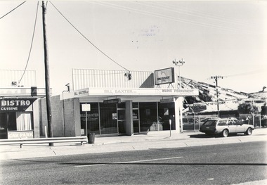
Photograph - Codling Collection 01 - Wodonga, High Street West - Emilio's Bistro, Bill Baxter office, Hume Permanent, 1980s
Miss Olive Codling was a Foundation Member and a Life Member of the Wodonga Historical Society. Many of her prize-winning photos are held in the Society Collection. She also held a range of roles and committee positions in a wide range of Wodonga community organisations. These included the Horticultural Society, the Wodonga Arts Council, the Wodonga Camera Club and the Wodonga Lapidary Club. This photo collection is significant as it documents how the businesses and buildings in Wodonga have evolved and contributed to community throughout the 20th century.Wodonga, High Street West Businesses including Emilio's Bistro, Bill Baxter office, Hume Permanent and Sharrock Motors. Hume Permanent opened its branch at 97 High Street, Wodonga on 6th March, 1972 with Mr. D. Hepburn as manager. ‘Permanent’ was dropped from Hume Building Society’s name in 1988. These buildings have since been demolished and the area is part of the newly developed Junction Place, Wodonga. On shop facades - "BISTRO, Cuisine/BILL BAXTER MP/HUME PERMANENT"wodonga businesses, high st wodonga, emilio's bistro, hume permanent -
 Ringwood and District Historical Society
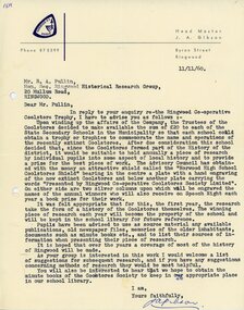
Letter, Norwood High School Coolstores Shield, 1960
Letter dated 11/11/1960 to Ringwood Historical Research Group from Headmaster, Norwood High School, Ringwood, Victoria, regarding Ringwood Co-operative Coolstore Trophy. Upon winding up the affairs of the Company, the Trustees of the Coolstores decided to make available the sum of £20 to each of the State Secondary Schools in the Municipality so that each school could obtain a trophy or trophies to commemorate the name and operations of the recently extinct Coolstores. -
 Ringwood and District Historical Society
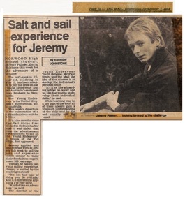
Newspaper - Clipping, Norwood High School, Ringwood, Victoria
Local newspaper - The Mail, September 7, 1988 - reporting selection of Norwood High School Student, Jeremy Palmer, to join the crew of the "Young Endeavour" as part of Australia's Bicentennial celebrations. -
 Kew Historical Society Inc
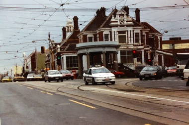
Photograph, Stewart West, Junction of High Street and Cotham Road, Kew, 2001, 2001
Photograph taken by Stuart West for an exhibit comparing past and present streetscapes in KewColour photograph by Stuart West of the junction of High Street and Cotham Road, Kew. The photo was shot in 2001. It shows the Kew War Memorial, former Post Office and Court House.kew post office, cotham road (kew), high steet (kew) -
 Greensborough Historical Society
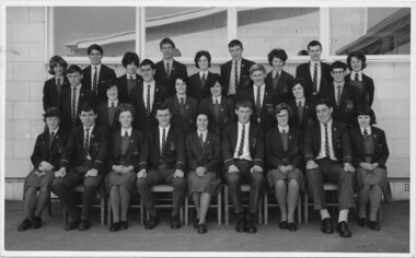
School Photograph - Digital Image, 1963 Macleod High School McHIGH Prefects, 03/04/1963
Photograph of Macleod High School 1963 Prefects.Digital copy of black and white group photograph.Names identified on back of photograph.macleod high school, rosemary davies -
 Greensborough Historical Society
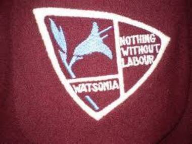
Photograph - Digital Image, Watsonia High School WaHIGH Logo, 1961_
A colour photograph of the Watsonia High School LogoWatsonia High School was a local educational facility that was closed in 1989. In 1961; the new secondary schools at Banyule and Watsonia shared facilities at Banyule while Watsonia was being built. Greensborough Secondary College opened in 1990 which merged Watsonia High and Watsonia Technical School students together. A digital copy of a colour photographwatsonia high school -
 Stawell Historical Society Inc
Photograph, Stawell High School Tennis Team -- Named 1930
Stawell High School Tennis Team 1930stawell education sport -
 Stawell Historical Society Inc
Photograph, Stawell High School Staff -- Named
Stawell High School – Staff Year Unknownstawell education -
 Stawell Historical Society Inc
Photograph, Stawell High School Staff -- Named
Stawell High School – Staff. Year Unknownstawell education -
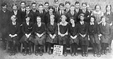 Stawell Historical Society Inc
Photograph, Stawell High School Form 5 -- Named 1927
Stawell High School 5th Form 1927stawell education -
 Stawell Historical Society Inc
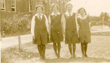
Photograph, Stawell High School Students -- Named c1920’s
Stawell High School Students 1920’sstawell education -
Stawell Historical Society Inc
Photograph, Stawell High School's Choir on a truck -- Named 1953
Stawell High School - Choir on a truck 1953stawell education -
Stawell Historical Society Inc
Photograph, Stawell High School Library Committee -- Named 1958
Stawell High School - Library Committee 1958stawell education -
Stawell Historical Society Inc
Photograph, Stawell High School Form 2A -- Named 1974
Stawell High School - Form 2A 1974stawell education -
Stawell Historical Society Inc
Photograph, Stawell High School Form 3C -- Named 1977
Stawell High School - Form 3C 1977stawell education -
Stawell Historical Society Inc
Photograph, Stawell High School Form 4A -- Named 1978
Stawell High School - Form 4A 1978stawell education -
Stawell Historical Society Inc
Photograph, Stawell High School Form 4 -- Named 1957
Stawell High School - (John Neil Teacher)stawell education -
Stawell Historical Society Inc
Photograph, Stawell High School Form 3A -- Named 1970
Stawell High School - (E. Mackay Teacher)stawell education