Showing 116788 items
matching orbost-brodribb-road
-
 Eltham District Historical Society Inc
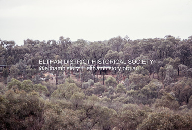
Photograph, Michael Wood, Houses on Progress Road viewed from Glen Park Road, Eltham North, February 1970, 1970
Wood family home (1969-2011) pre and post construction by Knox and Hellemons Shows Wood family home on Progress Road in centre of field of viewKodachrome 35mm colour transparency in cardboard mount Processing date FEB70M6Inscribed in ink "Hoses on Progress Rd from Glen Park Rd, Eltham North 1970"alistair knox design, eltham north, hellemon, houses, progress road, glen park road -
 Whitehorse Historical Society Inc.
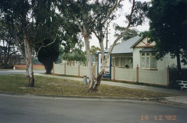
Photograph, Whitehorse Road, Mitcham No.427
427 Whitehorse Road, Mitcham was owned by the Copp family in the 1950s.|See also NP2519-2520 and NP2560, NP3245Coloured photograph of renovated old house at 427 Whitehorse Road, Mitcham, taken in 2002 from Whitehorse Roadwhitehorse road, mitcham no.427 -
 Whitehorse Historical Society Inc.
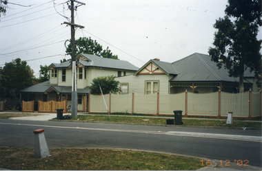
Photograph, Whitehorse Road, Mitcham No.427
427 Whitehorse Road, Mitcham, was owned by the Copp family in the 1950s|See also NP2519-2520 and NP2560, NP3244Coloured photograph of renovated old house at 427 Whitehorse Road, Mitcham, taken in 2002 from Dunlaven Roadwhitehorse road, mitcham no.427 -
 Ringwood and District Historical Society
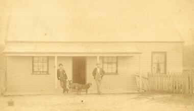
Photograph, C. Gribble, Oliver Pratt's residence and Butchers Shop, Main Road (Opposite Mt.Dandenong Road), Ringwood. Two photos c.1910 and c.1914 (Multiple Copies)
Multiple copies of two photos of Oliver Pratt's residence and butchers shop, Main Road (Opposite Mt.Dandenong Road). Earlier photo shows Mr. Oliver Pratt (Left) and Mr. James Kenneth McCaskill (Right) outside residence (c.1910). Later photo (c.1914) taken after Pratt's first butcher shop was added before subsequent shop established on the corner of Warrandyte Road. (Orignial photo IDs were MHE999, MHE7, F27)Written on back of sepia photograph, "Mr. J. K. McGaskill. Main Road on Pratt's Land?" Typed below another photograph, "Mr. O. J. Pratt's Butcher shop, Main St. east of Warrandyte Rd. - 1912. -
 Melton City Libraries
Photograph, West Melton-Coburns Road, 1969
Coburns Road - 19th c family descendents living in Melton. Coburn Primary School Cr George Coburn. 1930’s. December 1935 Shire President Cr Geo Coburn convened meeting to form the Bush Fire Brigade. Road construction of Service road and beginnings of West Melton subdivision. West Melton-Early Division View of Coburns Road. council, local significant events -
 Whitehorse Historical Society Inc.
Newspaper - Article, 178 Central Road, Nunawading, 18/04/1994
178 Central Road, Nunawading, Auction, Sunday 1 May 1994, Californian Bungalow, c1930 vintage with original features.central road, nunawading, californian bungalows, auctions -
Whitehorse Historical Society Inc.
Newspaper - Article, Junction Road, Blackburn North, 12/04/1995
7 - 21 Junction Road, Blackburn North. Article on weatherboard home c1903, Harwood Homestead, Edwardian / Federation house.harwood, junction road, blackburn north, nos. 17-21, killeen avenue, blackburn north, handley court, blackburn north, edwardian style, auctions -
 Orbost & District Historical Society
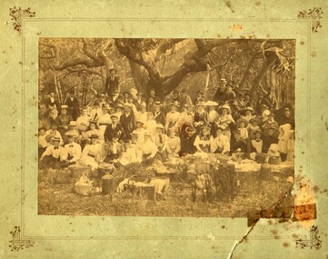
Photograph - Picnic at Old Station, Orbost
The Old Station Homestead site at Corringle Beach was a popular destination for Orbost people to have picnics late 19Century. They would travel out in buggies from Orbost or Newmerella with food hampers, have a picnic, play games etc. This location was always referred to as the Old Station because it had been one of the earliest Stations in this district in the early days of European settlement. evidence of recreation, entertainment in the Orbost districtA sepia coloured photograph pasted onto grey cardboard. Photo shows a group of people standing and sitting under trees with picnic baskets and hampers in the foreground. Many people wear hats. On back of photograph: Mrs Reynolds Senr, 72 Boundary Road. Old Station Beach, Orbost orbost, corringle, old station homestead site, picnic -
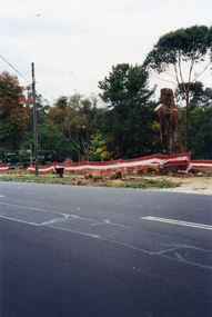
Whitehorse Historical Society Inc.
Newspaper - Articles, Central Road, Nunawading, 1953
Collection of Age and Reporter articles re native gums and wattlesCollection of Age and Reporter articles re native gums and wattles which were felled in Central Road, Nunawading for road widening which led to protests from angry residents.Collection of Age and Reporter articles re native gums and wattlescentral road., nunawading, roads and streets, native plants, moore, herbert, field, jean, uhl, wylie, alan -
 Eltham District Historical Society Inc
Slide, West side of Bonds Road at culvert end wall, Lower Plenty, 18 July 1972, 1972
Water drainage work undertaken by Eltham Shire Council in Bonds Road, Lower Plenty outside the Martin property opposite Montpelier Drive, July 1972 Pitchers in foreground were part of the end wall which was eroded out due to water crossing the road and not going through the culvert. 35 mm colour positive transparency Mount - Agfacolor Service (Blue)Bonds Road (Martin property) 12.10 pm 18.7.72bonds road, drainage works, eltham shire council, infrastructure, lower plenty, martin property, montpelier drive -
 Marysville & District Historical Society
Photograph (item) - Colour tinted photograph, Valentine Publishing Co. Pty. Ltd, The Road to Cumberland Valley, Marysville. No. 1, 1923-1963
An early colour tinted photograph of the intersection of the Buxton Marysville Road and the Marysville-Wood's Point Road.An early photograph of the Buxton Marysville Road and the Marysville-Wood's Point Road intersection. The Marysville-Buxton Road joins the Maroondah Highway which leads to Alexandra. The Marysville-Woods Point Road was originally part of the Yarra Track, constructed in the early 1860s to provide access between Healesville and the Woods Point Goldfields. Despite the steep terrain and engineering difficulties, the Yarra Track soon became a busy route used by pack horses, horse-drawn drays, and wagons. Today this sealed mountain road is a popular scenic drive between Marysville and Warburton. On the right of the photograph can be seen 'The Crossways Hotel' which is circa 1920 and one of the oldest buildings still standing in Marysville. 'The Crossways Hotel' survived the 2009 Black Saturday bushfires, through the efforts of the owner using buckets of water from the nearby Steavenson River. In the background can be seen the Poontawan Guest House which later became the Marysville Chalet Guest House which was on the site of the original Steavenson's Hotel. That guest house no longer exists and the Christ Church stands on the land where the guest house once stood. This photograph was published by the Valentine Publishing Co Pty. Ltd as a souvenir of Marysville.marysville, victoria, marysville chalet guest house, crossways hotel, christ church marysville, poontawan guest house, steavenson's hotel, valentine publishing co, souvenir, yarra track, wood's point road, mining, buxton-marysville road, marysville-wood's point road, maroondah highway, alexandra -
 Lakes Entrance Regional Historical Society (operating as Lakes Entrance History Centre & Museum)
Photograph, 1968
Black and white photograph of 44 students of Grade 4 State School Orbost Victoriagenealogy -
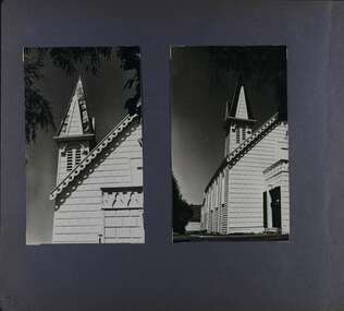 Glen Eira Historical Society
Album - Album page, Congregational Church, Grange Road, Circa 1972
This photograph is part of the Caulfield Historical Album 1972. This album was created in approximately 1972 as part of a project by the Caulfield Historical Society to assist in identifying buildings worthy of preservation. The album is related to a Survey the Caulfield Historical Society developed in collaboration with the National Trust of Australia (Victoria) and Caulfield City Council to identify historic buildings within the City of Caulfield that warranted the protection of a National Trust Classification. Principal photographer thought to be Trevor Hart, member of Caulfield Historical Society. Most photographs were taken between 1966-1972 with a small number of photographs being older and from unknown sources. All photographs are black and white except where stated, with 386 photographs over 198 pages. This church has since become the Greek Orthodox Church. From Victorian Heritage Database: Citation for Greek Orthodox Church HO84 https://vhd.heritagecouncil.vic.gov.au/places/43587 (as at 19/10/2020) The former Primitive Methodist, later Congregational, church at 152 Grange Road, Glen Huntly, is a small timber building, erected in 1885 (89?) in South Melbourne and relocated to Glenhuntly in 1909. It is a highly individual picturesque timber structure with distinctive spire and timber enrichment. It has aesthetic, historical and social significance. Its aesthetic value is derived from the choice of materials and picturesque Gothic Revival character showing American influence. Its historical value is derived from its survival as a rare example of a Primitive Methodist Church building whilst its social value hinges on its early roles as a place of worship for the Primitive Methodists in South Melbourne and the Congregationalists in Glenhuntly.Page 73 of Photograph Album with two photographs (both portrait) of front and side views of the spire of the Congregational Church on Grange RoadHand written: 73 [bottom left] trevor hart, congregational church, grange road, gothic revival, carnegie, glen huntly, glenhuntly, greek orthodox church, primitive methodist church, spire, timber buildings -
Whitehorse Historical Society Inc.
Newspaper - Article, Mitcham Road, Mitcham, 1/09/1993
Article on 476 Mitcham Road, Mitcham, built in 1958, for auction, 11 September 1993. Nunawading Gazette, 1 September 1993.mitcham road, mitcham, no. 476, auctions -
Whitehorse Historical Society Inc.
Newspaper - Article, 445-447 Mitcham Road, Mitcham, 4/04/1994
445 - 447 Mitcham Road, Mitcham, for sale by Robinson's Real Estate, 4 April 1994. 1920s house with potential for development.mitcham road, mitcham, nos. 445-447, real estate -
Whitehorse Historical Society Inc.
Pamphlet, Whitehorse Road, Blackburn, 1/08/1999
Whitehorse Road, Blackburn, No 73. Auction. Historical local landmark house built c1905. The house has many original features.whitehorse road, blackburn, auctions -
 Whitehorse Historical Society Inc.
Photograph, Deep Creek Road, 1/04/2001 12:00:00 AM
Coloured photograph looking from Schwerkolt Cottage Reserve across Deep Creek Road as work begins on construction of new Bridge.deep creek road, mitcham -
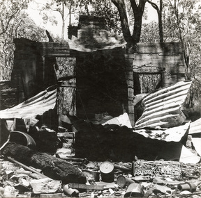 Eltham District Historical Society Inc
Photograph, George W. Bell, 'Windy' Gale's burnt out home, Wild Dog Creek Road, Jan. 1962, Jan 1962
Building of Pensioners Cottages at St Andrews; for those burnt out in the 1962 bushfires. A voluntary scheme of Mavis Gill through the Kangaroo Ground Relief CommitteeBlack and white photo mounted on card'Windy' Gale's burnt out home, Wild Dog Creek Road Photo Geo. W. Bell, Jan. 1962victorian bushfires - 1962, bushfires, dick (windy) gale, fire damage - buildings, george w bell, houses, st andrews, wild dog creek road, mavis gill, pensioners cottages -
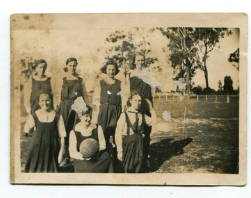 Orbost & District Historical Society
black and white photographs, 1920s
These photographs are of students of the Orbost Higher Elementary School. Information with photographs includes the names of those in the photos. 3143.1 - Alice Boucher; Bill Kerr; Mollie Hammil; Margie Trewin; ? Pen; Marion Nixon. 3143.2 - Back : Mollie Lock; Margaret Irvine; Lizzie Foard; Esme Reynolds; Marge Foard Front: Pen Gilbert; Mary Gilbert; Zenie Irvine; Hilda Bird. This was the first team to beat Bairnsdale High. 3143.3 - Marion with ball; ? Boucher; Myra Malcolm; L. Farquhar; ? Boucher; Mary Gilbert; Marion Trewin 3143.4 - Back - Alice Hammil; Marion Nixon; Bill Kerr; Annie Malcolm, E. Gall\Front - Marion Gilbert; Pen Gilbert; Elsie Pardew; Jean Trewin During 1910-11 the first approaches were made to the Department for the establishment of a HES in Orbost and this became a reality in 1912. Orbost HES supplied post-primary education in the district until a high school was built in 1948. Orbost High School / Orbost Secondary College has played a significant part in the education of senior students in the Orbost district . It is the sole senior educational institution. This item is representative of its historyFour black / white photographs of Orbost High School netball teams. 3143.1 is of seven girls in sports uniforms. Four are standing and three kneeling in front of them The girl in middle front is holding a ball. The photograph has been taken outside on a sports field with a low fence in the background. 3143.2 is of nine girls in sports uniforms. Five are standing and the front brow of four are seated on chairs. . The photograph has been taken outside. the two girls middle front are holding a ball on which is written "1920". 3143.3 is of nine girls in uniform in front of a brick wall. Four are standing, five seated on a bench. The girl middle front is holding a ball which has "Orbost H.E.S. 1926" written on it. 3143.4 is a photograph / postcard. It is of nine girls in two rows. Five at the back are standing and the front row is seated on a bench. On the ball held by girl 2nd left is written "1923". The photograph has been taken outside and there is a gazebo in the background. There is a trophy on the ground in front of them.3143.2 - "O.H.E.S. 1920" 3143.4 - Bottom right corner -"L.N."education-orbost orbost-higher-elementary-school school-sport netball -
 Sherbrooke Foothills Historical Society
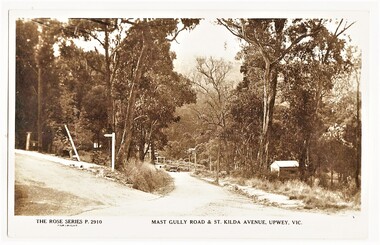
Postcard - The Rose Series P.2910 Mast Gully Road & St.Kilda Avenue, Upwey, Vic. (identification item name), The Rose Series P.2910 Mast Gully Road & St.Kilda Avenue, Upwey, Vic. (identification title)
Rare view of mast Gully rd with sign post for St.Kilda Avenue ( contextual or historic information)Digital copy of original postcard published on ebay. The Rose Series P.2910 Mast Gully Road & St.Kilda Avenue, Upwey, Vic.( inscription) The Rose Series P.2910 Mast Gully Road & St.Kilda Avenue, Upwey, Vic.mast gully rd, st kilda ave, roads, upwey, signpost, rose series, subjects in context -
 Kiewa Valley Historical Society
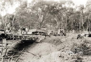
Black and White photograph of Road Making Machinery, Kiewa Road Making 25/8/1938(No. 3 in a series of 8), 25/08/1938
Construction of the main road from South Tawonga to the Bogong High Plains, to provide access to the construction sites for the new Kiewa Hydro Electric Scheme, was commenced early in 1938, the work being undertaken on behalf of the Commission by the Country Roads Board. For the construction work, the Commission purchased three Caterpillar - model R07 - diesel crawler tractors equipped with Kay Brunerei (Brunner) hydraulically operated trail builders (angle dozers)). This acquisition resulted from a visit to the United States of America in May, 1937 by the Construction Engineer ( Mr. C.H. Kernot) and Assistant Civil Engineer (Mr. J.F. Douglas) where they saw this relatively new type of equipment in use. With the co-operation of the CRB, the Commission demonstrated the operation of these machines at Fishermen's Bend on 6th April, 1938. They were then sent to Kiewa where they commenced operation towards the end of the month. From South Tawonga, the route led immediately across the Western Branch of the Kiewa River necessitating the construction of a bridge 100 feet long. By the end of 1939,the excavation had been 'opened up' for a distance of 19 1/2 miles (approx. 31 km.) and of this length, 10 miles (approx. 16 km) had been surfaced.The purchase and use of this type of mechanical equipment in road making was a huge investment, as prior to this most of the work would have been done manually with the use of picks and shovels. Not only were many months of hard manual labour saved, but a very significant amount of time in providing access to the proposed work sites for the new Kiewa Hydro Scheme. This photo is an excellent reminder of how primitive the early machinery was compared to the present but also represents the forward thinking of the State Electricity Commission's Engineers in purchasing such new and innovative equipment.A black and white photograph of a Caterpillar diesel crawler tractor and a hydraulically operated trailbuilder (angle dozer) making a road in the Mt. Beauty area.Hand written in black ink in the top left hand corner are the words "Kiewa Road Making 25/8/1938". On the upper right hand of the photograph has been stamped the number 3. On the back is stamped the word 'Velox' severaly times, which is the make of the photograhic paper. roadmaking, caterpillar tractor, kiewa, state electricity commission -
 Whitehorse Historical Society Inc.
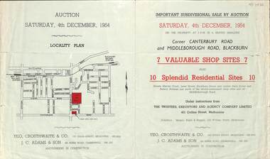
Pamphlet - Auction Flyer, Yeo, Crosthwaite & Co, Corner Canterbury Road and Middleborough Road, 4th December 1954
A green folded pamphlet advertising the sale of by auction of a shop and residential sites on the corner of Canterbury and Middleborough Roads, Blackburn on Saturday, 4 December 1954.A green folded pamphlet advertising the sale of by auction of a shop and residential sites on the corner of Canterbury and Middleborough Roads, Blackburn on Saturday, 4 December 1954.non-fictionA green folded pamphlet advertising the sale of by auction of a shop and residential sites on the corner of Canterbury and Middleborough Roads, Blackburn on Saturday, 4 December 1954.canterbury road blackburn, beck street, middleborough road blackburn, marion court, amery avenue, janet street, duckham street -
 Mt Dandenong & District Historical Society Inc.
Photograph, The Wagon Road, c1970s
The old Wagon Road built 1876-1878. This photograph has a detailed inscription on the back handwritten by John Lundy-Clarke in 1974.The Wagon Road. Built 1876 – 8. The first settler’s road in the Ranges as apart from Dray Tracks. Was built through Jeeves Selection, Crown Allotment “C” named “Jeeves saddle” and removed the monopoly held over travel through the Gap. jeeves saddle, kalorama, road, wagon road, john lundy-clarke -
 Eltham District Historical Society Inc
Photograph, Oxley Bridge construction, Henley Road, Kangaroo Ground, 1962, 1962
This is copy of a photograph taken 1962, during the construction of Oxley Bridge at Kangaroo GroundBlack and white photograph of Oxley Bridge construction over Watsons Creek, Henley Road, Kangaroo Ground, circa Aug-Sep 1962kangaroo ground, oxley bridge, watsons creek, henley road, bridges -
Whitehorse Historical Society Inc.
Newspaper - Article, 23 Boronia Road, Vermont, 1991
Newspaper article re 23 Boronia Road, Vermont. Auction. expected price: $500,000. c 1890 Home of Fay and Harry Williamsboronia road, vermont, no. 23, auctions., williams, fay, williams, harry -
 Whitehorse Historical Society Inc.
Photograph, Deep Creek Road, Mitcham, 1/09/2000 12:00:00 AM
Black and white photo looking North along Deep Creek Road, Mitcham, from Car Park at Schwerkolt Cottage Museum Complex.mitcham -
 Whitehorse Historical Society Inc.
Photograph, Deep Creek Road, 1/04/2001 12:00:00 AM
Coloured photograph looking from Schwerkolt Cottage Reserve across Deep Creek Road as trees are cut down for construction of new Bridge.deep creek road, mitcham, vicroads -
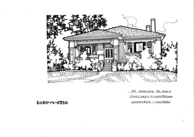 Hawthorn Historical Society
Drawing - Property Illustration, 49 Havelock Road, Hawthorn East, 1993
'After training as a Cartographic Draftsman within the mining industry, I worked as a property illustrator for real estate firms in the eastern suburbs of Melbourne for 23 years from 1983. I initially photographed houses with a Polaroid camera and made a 'thumbnail' sketch while there. The photos were used to scale off a sketch in pencil and then that sketch was overlaid with drafting film and the 'pen and ink' completed. The pens I used were the Rotring ‘Rapidigraph’ drafting pens. The ink was also made by Rotring (German).The film was ‘Rapidraw’, polyester drafting film, double matte. It takes a very fine line and doesn’t bleed. As well as house sketches, there were often floor plans and site plans ordered. Aerial sketches were ordered when the property needed an overall view.' (Margaret Picken, 2020)This property illustration is one of a series created by Margaret Picken for a range of real estate agents in Melbourne between c. 1983 and c. 2006. Each work is signed and dated by the artist.Gift of Margaret Picken, 2020pen and ink architectural drawing on drafting film. Dimension 255x165 Inscription: 49 HAVELOCK ROAD, HAW E Margaret Picken ©2000 WOODARDS -C'WELL49 HAVELOCK ROAD, HAW E Margaret Picken ©2000 WOODARDS -C'WELLartist - margaret picken 1950- -
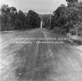
 Eltham District Historical Society Inc
Photograph, Michael Wood, Progress Road looking east from Scenic Crescent, Eltham, 1976, 1976
Progress Road between Ryans Road and Lower Road, Eltham North; prior to realignment and construction, 1976Kodak Safety Film 120 format 6 x 6 cm black and white negative; 3 strips, 12 frames Also 30 x 25 cm black and white print of this image frameeltham north, scenic crescent, progress road, road construction -
 Eltham District Historical Society Inc
Photograph, Michael Wood, Progress Road looking east from outside No. 180, Eltham North, 1976, 1976
Progress Road between Ryans Road and Lower Road, Eltham North; prior to realignment and construction, 1976Kodak Safety Film 120 format 6 x 6 cm black and white negative; 3 strips, 12 frames Also 30 x 25 cm black and white print of this image frameeltham north, progress road, road construction