Showing 10751 items
matching plan
-
 Federation University Historical Collection
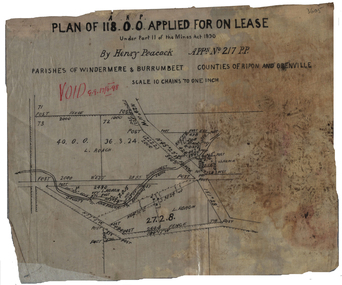
Plan, Henry Peacock's Lease, 1898, 1898
Plan on linen of Henry Peacoack's application for a lease. Scale: 10 chains to 1 inch (1:7920)henry peacock, mining lease, l. roach, windermere, burrumbeet -
 Federation University Historical Collection
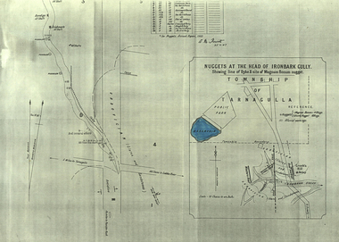
Plan, A.M. Howitt, Nuggets at the Head of Ironbark Gully, Tarnagulla, c1907
Plan showing part of the township of Tarnagulla, and the Ironbark Gully area including Western Reef and Creek's Hill.tarnagulla, ironbark gully, western reef, creek's hill, cgt -
 Greensborough Historical Society
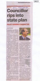
Newspaper Clipping, Diamond Valley Leader, Councillor rips into state plan, 09/03/2016
Cr Wayne Phillips comments on the Victorian government's planning issues regarding residential zones.News clipping, black text, colour image.wayne phillips, residential planning, banyule councillors, banyule city council -
 Vision Australia
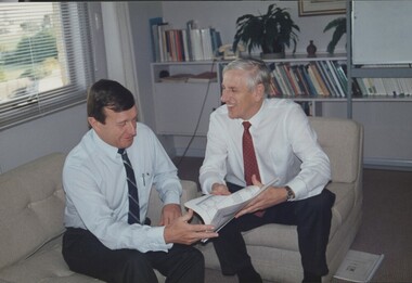
Photograph - Image, John Moule and John Cook looking at the 1992 business plan, 1992
John Moule and John Cook sit in the CEO's office, looking at the 1992 business plan.3 coloured photograph of John Moule and John Cookjohn moule, john cook, association for the blind -
 Melbourne Tram Museum
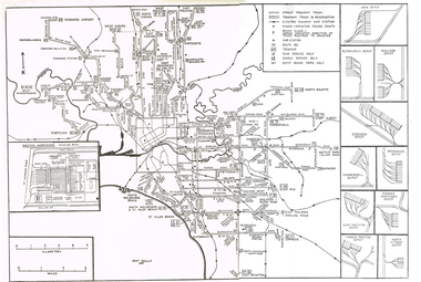
Map, Track plan or track map or layout of the Melbourne system, c1973
Track plan or track map or layout of the Melbourne system showing track layout, crossovers, depots, workshops and route numbers, terminus, substations, Bundy clocks, layout of Preston works. On the rear is a detailed layout of the city area. Shows railway stations but not the station names and rivers. Printed on cartridge paper. No details of to who prepared the plan or the drawing or date. Wattle Park line has been duplicated (Sept 1970), but the Essendon Airport line remains (closed Oct. 1976).trams, tramways, mmtb, track layout, junction, depots, substation, plans, trackwork, route numbers, terminus, map, bundy clock -
 Melbourne Tram Museum
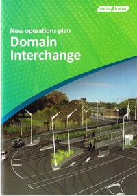
Document - Instruction Book, Yarra Trams, "New Operations Plan - Domain Interchange", 2013
Instruction book - 20 pages, printed on gloss paper, full colour, A5 centre stapled titled "New Operations Plan - Domain Interchange", outlining the change to the Domain Junction tram stop and track arrangements, that were built during March and April 2013. Has a table of contents, map, summary of changes, stop features, operations plan for St Kilda Road and Route 55 service, arrangements while being built, and general rules. Signed by Dennis Griffiths, Director of Operations.trams, tramways, yarra trams, domain junction, route 8, route 55, road works, st kilda rd, tram stops -
 Lakes Entrance Regional Historical Society (operating as Lakes Entrance History Centre & Museum)
Book, Dept of Natural Resources and Environment Victoria Publisher, Fisheries Victoria Management Report Series Lake Tyers Fisheries Reserve Management Plan No 43, 1997
Draft Management Plans prepared under the Heritage Rivers Act set out the proposed basis for future management of Heritage Rivers and Natural Catchment Areas. Gippsland catchments are significant for the essential undisturbed conditionISBN 0730667936environment, waterways -
Whitehorse Historical Society Inc.
Article, Councils slate transport plan, 1979
The reaction of Camberwell and Nunawading Councils to a newly released State Government plan for transport in the area.The reaction of Camberwell and Nunawading Councils to a newly released State Government plan for transport in the area. Most proposals are concerned with the extension of freeways or improvement of roads. Concern is expressed about the lack of public transport improvements.The reaction of Camberwell and Nunawading Councils to a newly released State Government plan for transport in the area.city of nunawading, city of camberwell, roads and streets, transport, public transport, eastern freeway -
Whitehorse Historical Society Inc.
Article, Residents to fight plan for forced payments, 1993
Angry residents will fight Nunawading Council's plans to construct Bell Street and charge them half.Angry residents will fight Nunawading Council's plans to construct Bell Street and charge them half. Unlike most other private street schemes they don't live in the street and yet are being forced to contribute.Angry residents will fight Nunawading Council's plans to construct Bell Street and charge them half.road construction and maintenance, bell street, blackburn, city of nunawading, francis street, blackburn, erli court, blackburn -
Whitehorse Historical Society Inc.
Article, Housing plan for reserve, 2012
VicRoads has earmarked large parts of the Healesville Freeway Reservation for housing under concept plans for the land's future.VicRoads has earmarked large parts of the Healesville Freeway Reservation for housing under concept plans for the land's future. Some community groups and Whitehorse Council are calling for the entirety of the reserve to be preserved as open space.VicRoads has earmarked large parts of the Healesville Freeway Reservation for housing under concept plans for the land's future. healesville freeway reservation, whitehorse -
 Melbourne Tram Museum
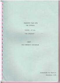
Document - Report, State Co-ordination Council of Vic, "Transport Plan 1978 for Victoria", Dec. 1978
Reports - "Transport Plan 1978 for Victoria" Draft for Community Discussion - Released December 1978. .1 - Vol 1 - "The Strategy" - 48 pages, comb bound with green card coves. Looks at issues and policies in general, metro and non metro, transport policies and basic strategy. .2 - Vol 2 - "The five year plan" - 52 pages, comb bound with manila card covers with two fold out plans, looking at funding, a work program, projects and a bibliography for the three volumes. .3 - Vol 3 - "Basic Transport Data" - 108 pages, comb bound with blue card covers, with many tables and figures, looking at various demographics, metrics, including historical background, transport administration, existing transport system, travel characteristics and forecasts.trams, tramways, public transport, road transport, melbourne -
 Federation University Historical Collection
Plan, Haddon, County of Grenville, 1932, 13/04/1932
The Haddon Parish Plan shows crown parcels government roads, Crown Reserves, Railway. Scale 40 chains to 1" (1:31, 680) WGS 84 Centroid Lat: 37 degrees 34' 00" S Long: 148 degrees 40' 20" E N.S. 9.3km E.W.: 16.1kmhaddon, grenville, cardigan, water supply reserve, nentingbook pre-emptive right, a. mclachlan, lake burrumbeet, e.a. wynne, p. russell, b. hepburn, benjamin hepburn, nentingbool, t.c. wilson, j. amoy, william collard smith, james roach, j. mitchell -
Potter Farm Collections (RMIT Hamilton)
Video recording, Richard Keddie, Potter Farmland Plan Video
Educational workshops were held as part of the Potter Farmland Plan Project for participating farmers and the community.These videos demonstrate the community participation and teaching/learning styles that were an integral part of the project. They also demonstrate agricultural extension programs that were typical in the 1980'sBeta Film 2 reels No 31 & 32 Farmers Workshop Duration: 45 min. Shot 20/11/1989 agriculture, potter farmland plan, agricultural education, rural community, western victoria -
 Greensborough Historical Society
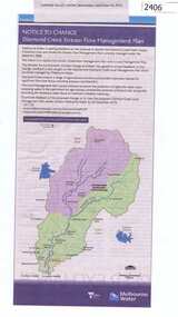
Newspaper Clipping, Diamond Creek stream flow management plan, 30/09/2015
In this Public Notice, Melbourne Water seeks feedback on the Diamond Creek Stream Flow Management Plan.News clipping, black text, colour map.diamond creek stream flow management plan, melbourne water. -
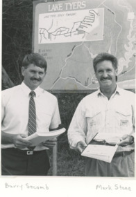 Lakes Entrance Regional Historical Society (operating as Lakes Entrance History Centre & Museum)
Photograph, Lake Tyers Beach Strategy Plan. Lake Tyers Beach progress Association
Launch of Lake Tyers Beach Strategy Plan . Second photo of Joe Taylor at his farewell Black and white photograph of Cr. Barry Secomb (Tambo Shire), Mark Stone(Regional Manager DCE) . Plus second photo of members of Lake Tyers Beach progress Association clubs, township planning -
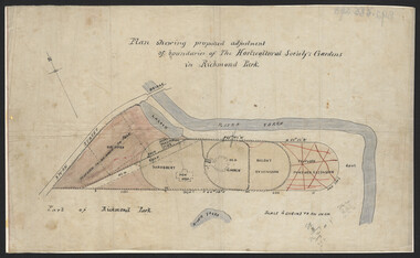 University of Melbourne, Burnley Campus Archives
Plan, John S. Jenkins, Plan showing proposed adjustment of boundaries of the Horticultural Society's Gardens in Richmond Park, c.1880-1884
Plan on linen fibre cloth. Shows layout of Burnley bound by Swan St., Yarra River and part of Richmond Park, coloured areas showing proposed area to be added to Park, the old road, shrubbery, new hall, old garden, recent extension and proposed further extension (crossed out in red ink). Scale 4 chains:1 inch. Probably drawn by John S. Jenkins, Town Surveyor, Richmond. Has been photographed so that additional copies can be made. On a CD plus 3 negatives, plus small coloured print. (Also copy glazed and framed for Centenary Exhibition - B92.0540.)john s. jenkins, gardens, richmond, hoticultural society of victoria -
Stawell Historical Society Inc
Map - Plan, Earle and Partners, Restoration of Pleasant Creek Courthouse Stawell West 1974, 24/10/1974
Drawing 1 Is not in Collection Drawing 5 Landscape Pal is 5092-13 A2 Sheets. Drawing 3 is Elevations. Drawing 2 is Gallery And Roof Plan. Drawing 4 Details24 Oct 74. And 25 Oct 74stawell historical -
Federation University Historical Collection
Plan, Nick O'Time Lead, Parish of Tarnagulla
A3 Photocopy of the Nick'O'Time Leadplan, mining, cgt, tarnagulla, nick o'time -
University of Melbourne, Burnley Campus Archives
Map, Plan of Early Melbourne Showing Original Crown Allotments, c. 1852
Copy of 'Map of the City of Melbourne, and its Extension, together with Collingwood, Richmond, Hawthorne, the Emerald Hill, and a portion of Prahran Compiled from the Government Plans and Private Survey by William Green.' (2 copies, one enlarged)melbourne, william green, richmond, hawthorne, collingwood -
Lakes Entrance Regional Historical Society (operating as Lakes Entrance History Centre & Museum)
Book, Martin Brian, The SS Lady Harriet Barge and other relics Conservation Plan, 1998
A conservation plan directed towards the SS Lady Harriet barge also known as the Stone Barge, positioned on the sand hummocks near the Flagstaff Jetty. The history and use of the vessel is discussed, and recommendations for the short term stabilisation aconservation, ships and shipping -
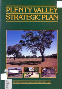 Greensborough Historical Society
Booklet - Leaflet, Plenty Valley strategic plan, August 1989
A 1989 planning document for the Plenty Valley growth area, as much of it moved from rural to residential zoning.8 p., text and col. illustrationsplenty valley, urban development, plenty river, shire of diamond valley, whittlesea -
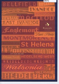 Greensborough Historical Society
Booklet, Banyule City Council: City Plan 2002-2005, 2002
City Plan 2002-2005 describes the vision, values and objectives of Banyule City Council for this period of time. 28 p., text and col. illus.council rates, councillors, banyule city council -
 Federation University Historical Collection
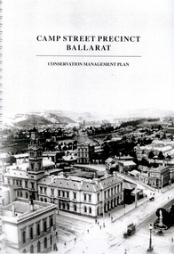
Book - Report, Camp Street Precinct Ballarat Conservation Management Plan, November 1999
This report was prepared for the City of Ballarat to assist in the process of planning for the future management and development of the Camp Street precinct.214 page report with spiral binding and a cover featuring a black and white image of the Ballarat Post Office, Ballarat Free Library and Ballarat State Offices. The report includes information on buildings in the Camp Street precinct including Art Gallery of Ballarat, old Colonists' Hall, former Police Court, former Police Station, Former Police Barracks, Government Camp (1852-1864), etcballarat fine art gallery, art gallery of ballarat, ballarat old colonists hall, ballarat former library, ballarat old court house, old ballarat police station, former ballarat post office, ballarat market reserve, ballarat benevolent reserve, bones building, old colonists hall, former ballarat call room, former ballarat police court, archaeology, aledandria tea room, former lister and angel warehouse, pratts warehouse, cms, conservation management plan, old colonists' hall, old colonists' association -
Federation University Historical Collection
Book, Tourism Destination Management (TDM) PL, Final Draft - Daylesford Regional Tourism Association Business & Tourism Plan, April 2005 - June 2008, 2005
Final Draft - Daylesford Regional Tourism Association Business & Tourism Plan, April 2005 - June 2008White bound book of 24 pages and includes two appendices.executive summary, background, situation analysis, best practice, gap analysis, strategic priorities, the rta structural considerations, resources, strategic action plan 2005/06-2007/08, 16 month implementation plan, daylesford, daylesford regional tourism association, creswick, macedon producers group, spa, therapy & health group, trentham residents and traders association, clunes tourism development association, creswick district development association, spa country chamber of commerce and tourism inc, john ellis, kylie lethbridge, barbara nixon, sue moses -
 Federation University Historical Collection
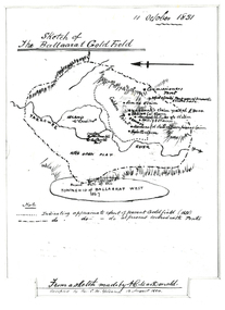
Plan, Sketch of Ballaarat Gold-Field, 1851, 11/10/1851
The sketch was made by A.C. MacDonald, F.R.G.S. and presented to James Oddie, who was one of the earliest gold diggers at Ballarat..1) Reproduction of a line sketch plan of the Ballarat goldfield as it was on 11 October 1851 as drawn by A.C. MacDonald, and recopied by C.M. Yelland. The dots indicate appoximate extent of the Ballarat Goldfield in 1851. The dot and dash line indicates approximate area covered with tents. .2) Includes an indication of the locality of the Township of Baallarat West in 1867. Verso of cat. No. 4296.2, and written by Keith Rash - "On 10th October 1851, 1,300 licenses had been issued. 30th October 1851 2246 licenses. Lieut. Gov. LaTobe letter to Earl Grey." james oddie, a c macdonald, gold commissioner, mcleod, alfred clark, kavanagh, willis, highett, yarrowee river, a.c. macdonald, ballarat goldfield, ballaarat goldfield, lamda, c.m. yelland -
 Greensborough Historical Society
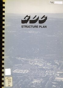
Book - Planning Document, TTM Consulting Pty Ltd, Greensborough District Centre: Structure plan, 1989, 1989_07
A summary of investigations into impacts of the Greensborough District Centre in 1989, with plans for the development of the East side of Main Street Greensborough.91 pages text and black and white line drawings. One colour fold out map. Black plastic binding and clear plastic cover. greensborough district centre, main street greensborough, greensborough plaza -
Whitehorse Historical Society Inc.
Article, Rezoning plan riles retailers, 1992
Despite widespread disapproval by traders and residents, Nunawading Council still plans put its draft structure plan for Vermont South Activity Centre on public display.Despite widespread disapproval by traders and residents, Nunawading Council still plans put its draft structure plan for Vermont South Activity Centre on public display. Council owned land on Burwood Highway is earmarked for rezoning to restricted business zone. The draft has designated the area for a mix of office and retail development. it is not intended to duplicate retail services which already exist. Manager of Vermont South Shopping Centre Patricia Wilson says the traders object to any amount of extra retail development.Despite widespread disapproval by traders and residents, Nunawading Council still plans put its draft structure plan for Vermont South Activity Centre on public display.shops, city of nunawading, wilson, patricia, vermont south shopping centre, burwood highway, vermont south, nos 473-493 -
 Ballarat Tramway Museum
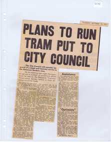
Newspaper, The Courier Ballarat, "Plan to run tram put to City Council", 12/10/1971 12:00:00 AM
Newspaper clipping from The Courier, 12/10/1971, titled "Plan to run tram put to City Council" about the City of Ballaarat considering plans from the BTPS for the construction of a depot in the South Gardens Reserve, consideration of a grant of $750 for the sheltering of tram No. 14. Quotes President Hal Cain about the proposals of the Society, and elements of the submission to council requesting assistance to run the track from View Point to Carlton St. Sir Arthur Nicholson said "super optimists", refers to the editorial.. Cutting in two parts.btps, depot, city of ballarat, preservation -
 Melbourne Tram Museum
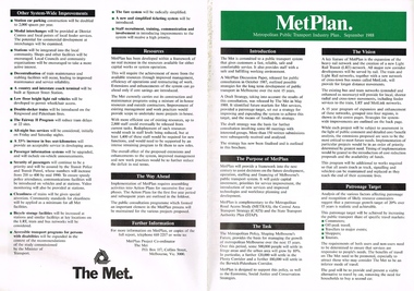
Pamphlet, The Met, "Met Plan", Sep. 1988
Folded A2 sheet to A4 size, full colour, printed both sides, titled "Met Plan" dated September 1988, detailing planning for Melbourne Public Transport, known as "MetPlan", prepared by The Met. Shows the various proposals for railway upgrades, tram extensions, details the purpose, the Task, Vision, Patronage, Resources, system improvements. Has details of projects proposed for the Western, Northern, Eastern and South Regions. On the inside has a large map of Melbourne showing the various projects. 2nd copy added 23-10-2016trams, tramways, melbourne, traffic control, transportation, met, planning, public transport, metplan, tramway proposals, railways -
Federation University Historical Collection
Document - Conservation Management Plan, Wendy Jacobs et al, Ballarat Municipal Observatory - Conservation Management Plan
A Conservation Management Plan of the Ballarat Municipal Observatory, produced by Dr David Rowe of Authentic Heritage Services Pty Ltd and Wendy Jacobs, Architect & Heritage Consultant for the City of Ballarat and the Ballaarat Astronomical Society in April 2007.astronomy, ballarat observatory, ballarat municipal observatory, conservation management plan, cmp