Showing 1627 items matching "river yarra"
-
 Kew Historical Society Inc
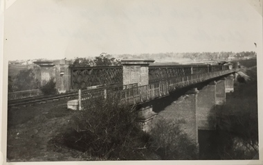
Photograph, Railway Viaduct, c.1919
... Railway viaduct, Yarra River, linking Kew and Fairfield... of Miss Foley. Railway viaduct, Yarra River, linking Kew ...The railway viaduct linking Kew and Fairfield was created for the Outer Circle railway.Railway viaduct, Yarra River, linking Kew and Fairfield. Built by John Monash for the Outer Circle Railway. In 1930 converted into the Chandler Highway Bridge for vehicular traffic. The point-of-view of the photograph shows Kew in the distance. Annotations on reverse: "Outer Circle Railway Bridge (now Chandler Highway) Fairfield-Kew, about 1919. Property of Miss Foley.outer circle railway, railway viaduct (kew), john monash -
 Kew Historical Society Inc
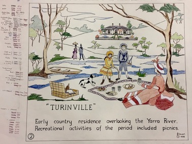
Work on paper, Joy Stewart, 2. Turinville, 1988
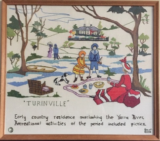
... overlooking the Yarra River. Recreational activities of the period... residence overlooking the Yarra River. Recreational activities ...Kew Tapestry The eight panels depict the history of Kew. This was a 1988 Australian Bi-Centennial Project carried out under the auspices of City of Kew Council and the Kew Historical Society Incorporated. Nearly 600 citizens including many children participated in the production by adding a few or more stitches. A book records their names and the panels upon which they worked. Artist: Joy Stewart Co-ordinator: Dorothy BenyeiSydney Joy (Joy) Stewart was born in Melbourne 1925. She studied at Swinburne Technical College Art School from 1941-1945, then the National Gallery Art School 1946-1948. Her career included employment positions as a display artist, designer/painter, gallery assistant, and art teacher. Joy relocated to Cairns in 1981. Solo exhibitions in Melbourne and Cairns, including 'Done By Me' at Cairns Regional Gallery in 1999. Group exhibitions at Cairns Regional Gallery, 'The Fish John West Regrets, 1993' and 'Facets of Life' 1994. Joy Stewart died in Cairns in 2018.2. Turinville. A Handcoloured cartoon created by the artist Joy Stewart as a template for the second of a series of embroidered panels depicting the history of Kew. Wool colour codes at left. Inscription: "TURINVILLE. Early country residence overlooking the Yarra River. Recreational activities of the period included picnics." Signed by the artist "(c) JStewart, 1988"bicentennial project (kew), turinville, joy stewart -
 Greensborough Historical Society
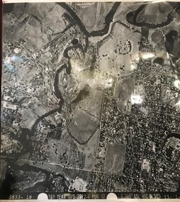
Aerial Photograph, Yan Yean M/S 7922 Run 17 No. 3833-18, 1/11/1984
... boundary Yarra River & Birrarung Park; East boundary east of Plenty... boundary Martin's Lane; South boundary Yarra River & Birrarung Park ...Covers Viewbank area: North boundary Martin's Lane; South boundary Yarra River & Birrarung Park; East boundary east of Plenty RiverLaminated black and white aerial photograph; adjoins 6227 on west sideviewbank -
 University of Melbourne, Burnley Campus Archives
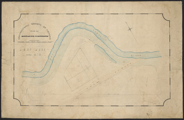
Plan, Horticultural Society of Victoria Plan of Gardens, Richmond, 1865
... Yarra River, Swan St., railway, plan of west orchard and old... showing Yarra River, Swan St., railway, plan of west orchard ...Plan on linen-backed paper of Burnley Gardens showing Yarra River, Swan St., railway, plan of west orchard and old garden sketched by hand in pencil. Inscription, "Presented to the Society, by A. Purchas C.E." Shows acreagesInscription, "Presented to the Society, by A. Purchas C.E." Oct 4th 1865"gardens, richmond, a. purchas, horticultural society of victoria -
 Greensborough Historical Society
Map, Keelbundora. Counties of Bourke and Evelyn, 1950_11
... Covers area bounded by Merri Creek, Yarra River, Plenty..., Yarra River, Plenty River and Crown Portions 24 to 28 ...Covers area bounded by Merri Creek, Yarra River, Plenty River and Crown Portions 24 to 28, with section including Maroondah Aqueduct and Darebin Creek.Photocopy of digitised mapkeelbundora (parish) -
 Greensborough Historical Society
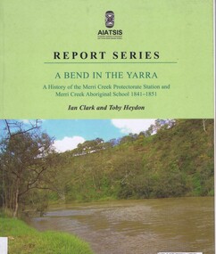
Book, Ian D. Clark et al, A Bend in the Yarra: a history of the Merri Creek protectorate Station and Merri Creek Aboriginal School 1841-1851, by Ian D. Clark and Toby Heydon, 2004_
... Creek and Yarra River.... at the confluence of the Merri Creek and Yarra River. merri creek aborigines ...A history of Aboriginal cultural institutions in colonial Victoria, in this book the interaction between Wurundjeri people and government officials and settlers at the confluence of the Merri Creek and Yarra River.Paperback book, 90 p. black & white illusmerri creek, aborigines victoria -
 Eltham District Historical Society Inc
Photograph, Peter Pidgeon, Killeavey, Laughing Waters Road, Eltham 5 Nov 2016, 5 Nov 2016
... The beautiful Yarra river lies before us; the scar or 'toe... melbourne The beautiful Yarra river lies before us; the scar or 'toe ...The beautiful Yarra river lies before us; the scar or 'toe hold' tree lies in front of Cam to the right Heriitage Excursion - Kileavey Walk and TalkBorn Digitalactivities, eltham district historical society, heritage excursion, kileavey, parks victoria, laughing waters road, eltham, wurundjeri -
 Whitehorse Historical Society Inc.
Document, Mullum Mullum River Piracy, 2025
... into the Yarra River.... into the Yarra River. Yarran Dheran Mullum Mullum Creek The history ...The history of Mullum Mullum CreekA4 8pnon-fictionThe history of Mullum Mullum Creekyarran dheran, mullum mullum creek -
 Kew Historical Society Inc
Textile - Bicentennial tapestry, 2. Turinville, 1988
... overlooking the Yarra River. Recreational activities of the period...: "TURINVILLE / Early country residence overlooking the Yarra River ...This is one of eight embroidered panels, completed during the 1988 Australian Bi-Centennial, and carried out under the auspices of City of Kew Council and the Kew Historical Society. Nearly 600 residents, including many children, participated in their production by adding a few or more stitches. A book records their names and the panels upon which they worked. Artist: Joy Stewart / Co-ordinator: Dorothy Benyei.1. Turinville. A framed embroidery created by adults and children of the City of Kew as a Bicentennial project, based on a design by the artist Joy Stewart. Five of the six completed embroideries created in the project are/were displayed in the Kew Library. [The five embroidered panels have now been temporarily removed for conservation reasons].Inscription: "TURINVILLE / Early country residence overlooking the Yarra River. Recreational activities of the period included picnics" Embroidered signature of the artist: "(c) JStewart, 1988"bicentennial project (kew), joy stewart, charles grimes expedition, australian bicentennial -
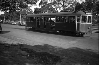
 Melbourne Tram Museum
Negative, Wal Jack, 10/02/1941 12:00:00 AM
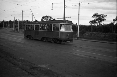
... in Swan St Richmond or Burnley after crossing the Yarra River... or Burnley after crossing the Yarra River bridge. Photo dated 10-2 ...Black and white negative, by Wal Jack, of No.Y1 611 inbound in Swan St Richmond or Burnley after crossing the Yarra River bridge. Photo dated 10-2-1941 in the Wal Jack album along with details of the location.trams, tramways, swan st, y1 class, burnley, tram 611 -
 Melbourne Tram Museum
Negative, Wal Jack, 1/09/1941 12:00:00 AM
... , Route 74) in Swan St Burnley, prior to crossing the Yarra River...) in Swan St Burnley, prior to crossing the Yarra River. Photo ...Black and white negative, by Wal Jack, of CW5 681, (Burwood, Route 74) in Swan St Burnley, prior to crossing the Yarra River. Photo dated 1-9-1941 in the Wal Jack album along with details of the location.trams, tramways, burnley, cw5 class, swan st, route 74, tram 681 -
 Greensborough Historical Society
Photograph - Digital Image, Plenty River Greensborough May 2014 -1, 21/05/2014
... meeting with the Yarra River at Rosanna. These images taken... Mt Disappointment before meeting with the Yarra River ...The Plenty River flows south from Mt Disappointment before meeting with the Yarra River at Rosanna. These images taken in the Greensborough area. Photograph by Marilyn Smith 2014.Digital copy of colour photograph.plenty river, greensborough -
 Eltham District Historical Society Inc
Negative - Photograph, Diamond Creek floodwater at Monash Bridge, Hurstbridge, Dec. 1934
... The historic 1934 flood of the Diamond Creek and Yarra... melbourne The historic 1934 flood of the Diamond Creek and Yarra ...The historic 1934 flood of the Diamond Creek and Yarra River following the storms of 29-30 November set the levels for future planning with respect to flood water rise.This photo forms part of a collection of photographs gathered by the Shire of Eltham for their centenary project book,"Pioneers and Painters: 100 years of the Shire of Eltham" by Alan Marshall (1971). The collection of over 500 images is held in partnership between Eltham District Historical Society and Yarra Plenty Regional Library (Eltham Library) and is now formally known as the 'The Shire of Eltham Pioneers Photograph Collection.' It is significant in being the first community sourced collection representing the places and people of the Shire's first one hundred years.Digital image 4 x 5 inch B&W Negshire of eltham pioneers photograph collection, hurstbridge, 1934 flood, floods, monash bridge, diamond creek (creek) -
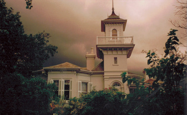 Kew Historical Society Inc
Photograph - 'Swinton', 23 Swinton Avenue, 2000
... of Swinton, 23 Swinton Avenue, Kew. Facade facing Yarra River... elevation of Swinton, 23 Swinton Avenue, Kew. Facade facing Yarra ...Swinton is of significance as one of the earliest examples of the use of the Italianate in Australian domestic architecture, and for the elegance of its design, particularly in the tower.Original colour positive photograph of the west elevation of Swinton, 23 Swinton Avenue, Kew. Facade facing Yarra River featuring tower and balcony with door and fanlight below. Projecting bay window at left. Rendered brick with slate roof. Ink on reverse: "Swinton - west elevation / Feb 2000"swinton, swinton avenue -- kew (vic.) -
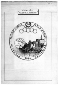 Federation University Historical Collection
Poster, Design for "Olympic Emblem" Melbourne, 1956, c1956
... an image of Melbourne buildings on the Yarra River, with a work... buildings on the Yarra River, with a work globe featuring ...The Olympic Games was held in Melbourne in 1956.White poster with black text and images. The poster shows an image of Melbourne buildings on the Yarra River, with a work globe featuring the outline of Australia. The poster also shows the olympic rings and relates to the 16th Olympic Games held in Melbourne in 1956.melbourne olympic games, melbourne, olympic games, poster -
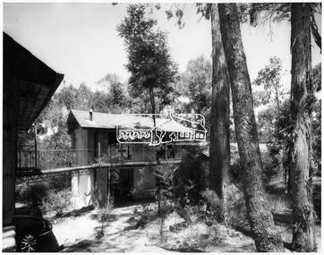 Eltham District Historical Society Inc
Photograph, Exterior of Professor Dick Downing's house - Eltham
... Dick Downing as a weekend house in mud brick on the Yarra river... Dick Downing as a weekend house in mud brick on the Yarra river ...Designed and constructed by Alistair Knox for Dorian Le Galliene, a composer and music critic and his companion Profesor Dick Downing as a weekend house in mud brick on the Yarra river at ElthamThis photo forms part of a collection of photographs gathered by the Shire of Eltham for their centenary project book,"Pioneers and Painters: 100 years of the Shire of Eltham" by Alan Marshall (1971). The collection of over 500 images is held in partnership between Eltham District Historical Society and Yarra Plenty Regional Library (Eltham Library) and is now formally known as 'The Shire of Eltham Pioneers Photograph Collection'. It is significant in being the first community sourced collection representing the places and people of the Shire's first one hundred years.Digital imagesepp, shire of eltham pioneers photograph collection, eltham, professor dick downing, alistair knox, dorian le galliene, house, dwelling, weekender -
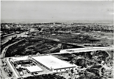 Port Melbourne Historical & Preservation Society
Photograph - Aerial view of Fisherman's Bend circa 1940, circa1940
... the Yarra River winding towards the city & North & South Wharves. ... on the left beside the Yarra River winding towards the city & North ...From the collection of Terry KEENAN. The 9 hole golf course known as the Sandridge Golf Club was part of Victorian Golf Clubs until it moved to Cheltenham in 1927. Trotting 'Speedway' located at top right of photograph.Black and white photograph of Fishermans Bend, Port Melbourne, c. 1940 showing General Motors Holden in the foreground. The original home of the Victoria Golf Club is shown on the left beside the Yarra River winding towards the city & North & South Wharves. built environment, fishermans bend, built environment - industrial, general motors-holden, victoria golf club, sport - golf, sport - horse racing -
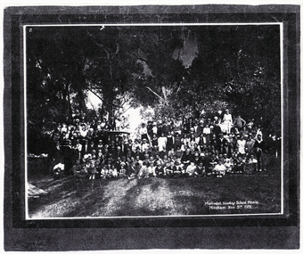 Whitehorse Historical Society Inc.
Photograph, Methodist Sunday School, 3/11/1931 12:00:00 AM
... to either Seaford beach or the Yarra River at Warrandyte.... or the Yarra River at Warrandyte. Methodist Sunday School Photograph ...Mitcham Methodist Sunday School Picnic taken 3 November 1931,at what is now Whitefriars College, Donvale. Methodist Sunday School picnic was an annual affair until the mid-1950's to either Seaford beach or the Yarra River at Warrandyte.methodist church mitcham -
 Eltham District Historical Society Inc
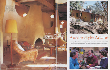
Magazine - Magazine Article, FPC Living, Aussie-style Adobe, Country Style, Jan/Feb 2001
... of Islands on the Yarra River. Built of mudbrick, timber... of Islands on the Yarra River. Built of mudbrick, timber ...Articles featuring the home of Carol-Anne and Tom Fisher designed by architect, Ross Henry in Santa-Fe style at Bend of Islands on the Yarra River. Built of mudbrick, timber and corrugated iron.mudbrick, carol-anne fisher, tom fisher, ross henry, santa-fe style, bend of islands, houses -
 Eltham District Historical Society Inc
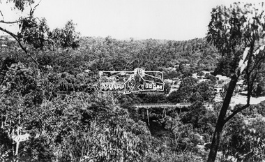
Photograph, View at Warrandyte, Vic, c.1937
... township. Taken from the northern side of the Yarra River from near... township. Taken from the northern side of the Yarra River from near ...View looking southeast across the bridge to Warrandyte township. Taken from the northern side of the Yarra River from near present day 244 Research-Warrandyte Rd, North WarrandyteThis photo forms part of a collection of photographs gathered by the Shire of Eltham for their centenary project book,"Pioneers and Painters: 100 years of the Shire of Eltham" by Alan Marshall (1971). The collection of over 500 images is held in partnership between Eltham District Historical Society and Yarra Plenty Regional Library (Eltham Library) and is now formally known as the 'The Shire of Eltham Pioneers Photograph Collection.' It is significant in being the first community sourced collection representing the places and people of the Shire's first one hundred years.Digital image 4 x 5 inch B&W Negshire of eltham pioneers photograph collection, warrandyte, north warrandyte, warrandyte bridge -
 Eltham District Historical Society Inc
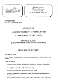
Newsletter, Newsletter, No. 112 January 1997
... • The “Shillinglaw Trees” • Yarra River Punt, Warrandyte • Annual General... • The “Shillinglaw Trees” • Yarra River Punt, Warrandyte • Annual General ...Contents: • Next meeting, Eltham on Video • 1997 Program • Former Eltham Shire Office Site – Planning Appeal • The “Shillinglaw Trees” • Yarra River Punt, Warrandyte • Annual General Meeting The Shire of Eltham Historical Society was formed in October 1967. The first newsletter of the Society was issued May 1978 and has been published continuously ever since on a bi-monthly basis. With the cessation of the Shire of Eltham in late 1994, the Society's name was revised to Eltham District Historical Society and this name first appeared with issue No. 103, July 1995. The collection of the Society's newsletters provides a valuable resource on the history of the Society's activities, office bearers and committee members, guest speakers and subjects of historical interest pertinent to the former Shire of Eltham and the Eltham District.A4 photocopied newsletter distributed to membersnewsletter, eltham district historical society, shire of eltham historical society -
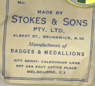 Clunes Museum
Memorabilia - NUMISMATICS, Stokes & Sons
... side depicts a pioneer on the south bank of the Yarra river... and the other side depicts a pioneer on the south bank of the Yarra ....1 White metal medal with a tricolour ribbon of red, white and blue. Attached to a ring connected to the medal. One side depicts the scene of landing at Portland in 1834 and the other side depicts a pioneer on the south bank of the Yarra river looking across Melbourne. On Reverse: Centenary of Victoria 1934 and Portland 1834 On Obverse: Centenary of Melbourne 1935 (AD)centenary of victoria 1934, centenary of melbourne 1935 -
 Melbourne Tram Museum
Negative, Wal Jack, 10/02/1941 12:00:00 AM
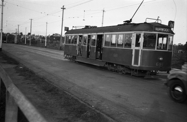
... Ave on its way to Burwood. Has the Yarra River... Batman Ave on its way to Burwood. Has the Yarra River ...Black and white negative, by Wal Jack, of No.CW5 684 Batman Ave on its way to Burwood. Has the Yarra River and the Gardens in the background. The tram is well loaded. Photo dated 10-2-1941 in the Wal Jack album along with details of the location.trams, tramways, batman ave, cw5 class, burwood, tram 684, route 74, mmtb -
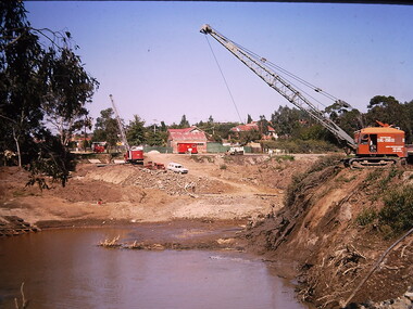 Kew Historical Society Inc
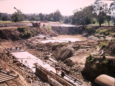
Photograph - Construction of the Eastern Freeway (F19), Ron Setford, March 1972
... the former river bed of the Yarra near Kilby Road and Willsmere Road.... The photo shows works diverting the former river bed of the Yarra ...Ron Setford and his wife Grace Setford lived in Tanner Avenue, East Kew, from c.1946 to c.1995. A keen photographer, he recorded the changing face of Kew over a 20 year period. Apart from 30 photographs of built structures and places in Kew dating from 1960 and 1961, 145 of his 35mm colour slides chronicle the development of the F19 (later renamed Eastern) Freeway through the Yarra Valley in Kew over a five year period from c.1972 to c.1977. This important collection was donated to the Society by his granddaughter in 2025.This collection of 175 35mm slides is of local and statewide significance, owing to its subject matter, particularly the major development of road transport infrastructure during the 1970s with the construction of the Eastern Freeway. The photographer also took care to annotate and date most of his slides which enable the researcher to pinpoint temporal and spatial locations.Photograph of works involved in construction of the F19 (now Eastern) Freeway. The photo shows works diverting the former river bed of the Yarra near Kilby Road and Willsmere Road, Kew."Eastern Freeway / Old River Bed / Kilby-Willsmere Rd"ron setford, eastern freeway, f19 freeway -
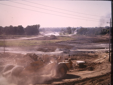 Kew Historical Society Inc
Photograph - Construction of the Eastern Freeway (F19), Ron Setford, March 1972
... river course of the Yarra.... the Yarra Valley in Kew over a five year period from c.1972 to c ...Ron Setford and his wife Grace Setford lived in Tanner Avenue, East Kew, from c.1946 to c.1995. A keen photographer, he recorded the changing face of Kew over a 20 year period. Apart from 30 photographs of built structures and places in Kew dating from 1960 and 1961, 145 of his 35mm colour slides chronicle the development of the F19 (later renamed Eastern) Freeway through the Yarra Valley in Kew over a five year period from c.1972 to c.1977. This important collection was donated to the Society by his granddaughter in 2025.This collection of 175 35mm slides is of local and statewide significance, owing to its subject matter, particularly the major development of road transport infrastructure during the 1970s with the construction of the Eastern Freeway. The photographer also took care to annotate and date most of his slides which enable the researcher to pinpoint temporal and spatial locations.Panoramic view of the Yarra Valley in March 1972 showing the early stages of the construction of the F19 (Eastern) Freeway. The photo shows the construction of an embankment to contain the new river course of the Yarra."Eastern Freeway / New river course preparing for embankment / Mar 72"ron setford, eastern freeway, f19 freeway -
 Eltham District Historical Society Inc
Negative - Photograph, Old Lower Plenty Bridge, 18 Apr 1998
... as a footway/bike path section joining the Yarra River path.... as a footway/bike path section joining the Yarra River path. activities ...EDHS Autumn excursion to Lower Plenty area The blocked-off iron bridge at Lower Plenty - now re-opened and used as a footway/bike path section joining the Yarra River path.Roll of 35mm colour negative film, 2 strips and associated colour printKodak Gold 200-6activities, lower plenty bridge, autumn excursion, eltham district historical society, lower plenty -
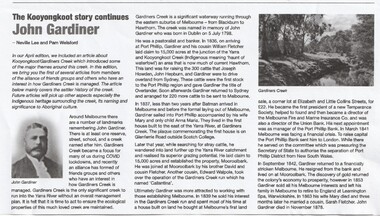 Whitehorse Historical Society Inc.
Article - John Gardiner, 23/06/2021
... at the junction of the Yarra River and Kooyongkoot Creek... at the junction of the Yarra River and Kooyongkoot Creek Early pioneer ...John Gardiner was born in Dublin 1798. He was a pastoralist and banker and arrived at Port Phillip in 1836 and with his cousin William Fletcher laid claim to 15,000 acres at the junction of the Yarra River and Kooyongkoot CreekJohn Gardiner was born in Dublin 1798. He was a pastoralist and banker and arrived at Port Phillip in 1836 and with his cousin William Fletcher laid claim to 15,000 acres at the junction of the Yarra and Kooyongkoot Creek.non-fictionJohn Gardiner was born in Dublin 1798. He was a pastoralist and banker and arrived at Port Phillip in 1836 and with his cousin William Fletcher laid claim to 15,000 acres at the junction of the Yarra River and Kooyongkoot Creekgardiner john, gardiners creek -
 Kew Historical Society Inc
Photograph - Yarra Flats near Burke Road Bridge, 1937
... Land along the Yarra River in Kew is now either designated... along the Yarra River in Kew is now either designated open space ...Land along the Yarra River in Kew is now either designated open space, parkland or public golf links. By the 1930s much of this area remained open farmland, bought at auction for dairy farming in the 1840s.Original, black and white positive print of what is said to be the Yarra Flats near Burke Road Bridge. On the horizon, building can be seen, whereas in the middle ground, farm fencing and a windmill are the main features as well as remnant Eucalypts. Inscribed verso: "Yarra Flats near Burke Rd Bridge 1937" studley park -- kew (vic.) -
 Kew Historical Society Inc
Photograph - Construction of the Eastern Freeway (F19), Ron Setford, March 1972
... (now Eastern) Freeway. The photo shows the old river bed.... The photo shows the old river bed of the Yarra and work to alter ...Ron Setford and his wife Grace Setford lived in Tanner Avenue, East Kew, from c.1946 to c.1995. A keen photographer, he recorded the changing face of Kew over a 20 year period. Apart from 30 photographs of built structures and places in Kew dating from 1960 and 1961, 145 of his 35mm colour slides chronicle the development of the F19 (later renamed Eastern) Freeway through the Yarra Valley in Kew over a five year period from c.1972 to c.1977. This important collection was donated to the Society by his granddaughter in 2025.This collection of 175 35mm slides is of local and statewide significance, owing to its subject matter, particularly the major development of road transport infrastructure during the 1970s with the construction of the Eastern Freeway. The photographer also took care to annotate and date most of his slides which enable the researcher to pinpoint temporal and spatial locations.Photograph of works involved in construction of the F19 (now Eastern) Freeway. The photo shows the old river bed of the Yarra and work to alter the Kew Main Drain where it originally entered the river. "Eastern Freeway / Old River Bed / Alterations to Kew S/water Drain"ron setford, eastern freeway, f19 freeway -
 Port Melbourne Historical & Preservation Society
Photograph - Various wharf/pier locations, 1920 - 1922
... , and the Interstate Swinging Basin (near Charles Grimes Bridge) in Yarra River... Basin (near Charles Grimes Bridge) in Yarra River 1920s ...Original photos. Eighteen loose photos in separate box . Charles Wynn Kiver Allison M.I.E.A.. Namely the New Pier (Princes), Railway Pier, Williamstown, Centre Pier in Victoria Dock, and the Interstate Swinging Basin (near Charles Grimes Bridge) in Yarra River 1920spiers and wharves - miscellaneous, piers and wharves - princes pier, charles wynn kiver allison, victoria dock