Showing 8447 items
matching snowy-river-dry-cleaners
-
 Greensborough Historical Society
Book, Melbourne Water, Plenty River Waterway Management Activity Plan 2000, 2000_
This report covers the catchment of the Plenty River from its upper reaches in the Great Dividing Range to the confluence with the Yarra River at Viewbank. It discusses ecological diversity and methods of improving water quality and significant areas of the catchment. Includes a brief history of settlement along the Plenty River.This is a significant plan for the improvement of the Plenty River.207 p., maps, folding maps. Printed on white paper with black spiral binding and clear plastic front cover.plenty river, melbourne water -
 Greensborough Historical Society
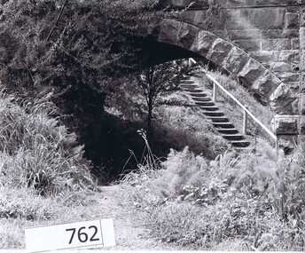
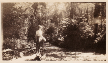
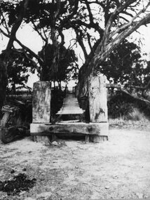
Photograph Collection, Richard Pinn, Plenty River 1979, by Alan Pinn, 1979_
Photographs of the Plenty River Greensborough. One shows Richard Pinn walking his dog (Jah) on track by river, the second photo is a close up of the Greensborough Bluestone Bridge and steps to river. The bridge has since been demolished and the path replaced by a concrete bike/walking path.Shows the river pathways and bluestone bridge in the 1979.2 b&w photographs.plenty river, greensborough, richard pinn -
![Book - Article, Fiona Weaver, Lower Plenty River Archaeological Survey by Fiona Weaver [excerpt], 1991](/media/collectors/62fc2e8d3b4c83fe7f279a1c/items/6450d73a49371722cf4f2ee8/item-media/6450d9b949371722cf4f5830/item-fit-380x285.jpg) Heidelberg Golf Club
Heidelberg Golf ClubBook - Article, Fiona Weaver, Lower Plenty River Archaeological Survey by Fiona Weaver [excerpt], 1991
Excerpt from Lower Plenty River Archaeological Survey by Fiona Weaver. Section 5 on Aboriginal archaeological sites in the Lower Plenty River area.A survey of First Nations sites in the Lower Plenty River area.Copy of part of book.lower plenty river, aboriginal sites -
 Tarnagulla History Archive
Photographs: Buildings in Newbridge near Loddon River bridge, Buildings in Newbridge near Loddon River bridge, 1908 (original image)
Depicts at left, Petersen's bakery, a store shed, Simpson's storekeepers and Simpson's Hotel. Hollands blacksmith shop & wheelwrights on right opposite bakery. Murray Comrie Collection. Three copies of a monochrome photograph, image depicts buildings in the eastern approach to the Loddon River bridge at Newbridge This is a fairly dark copy of an older original. Copy probably made by Murray Comrie in the 1960s.newbridge, loddon river, bridge, shops, stores, businesses, hotels, simpsons, petersens, bakery -
 University of Melbourne, Burnley Campus Archives
Photograph - Black and white print, Children Playing in the River, Unknown
Black and white photograph. Children standing on rocks in the river (Yarra?) with a bridge above them. T H Kneen suggests it is the Melbourne Hawthorn Railway Bridge and that The Boulevard now passes under the arch.children, rocks, river, bridge, yarra, hawthorn railway -
 Lakes Entrance Historical Society
Photograph - steamer landing on Tambo River East Gippsland Victoria, 1900 c
A popular Sunday outing venue was at Tambo UpperCopy of black and white photographic print showing large picnic party, steamer possibly Tanjil in background at a steamer landing on Tambo River between Swan Reach and Bruthen East Gippsland Victoriarivers, boats and boating, steamers -
 Warrnambool and District Historical Society Inc.
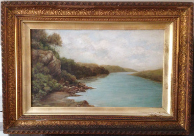
Painting, Hopkins River - Clifton Banks, Early 20th century
Clifton Banks is the name given to a bank on the Hopkins River Estuary, about one kilometre upstream from Proudfoots Boathouse. It is at the foot of the property, Clifton which dates from the 1850s. There are several works of art and photographs depicting Clifton Banks which date from the 19th and early 20th centuries. This oil painting is believed to be the work of Emma McGeorge, the wife of Canon Samuel McGeorge, the Vicar of Christ Church, Warrnambool form 1899 to 1905. It is surmised that Emma McGeorge was encouraged by the artist Mary Norman to take up painting as a pastime or to continue with her art interests. Emma McGeorge may have been a pupil of Samuel Pearce Fuller and Mary Norman. She was successful as an exhibitor and entrant in art exhibitions in Warrnambool in the early 1900s. She died in Warrnambool in 1933. This is a highly significant art work as it has artistic merit and is one of the depictions of Clifton Banks on the Hopkins River and so has historical value. It is an example of the high standard of art work that was being produced, especially by women, in the late 19th and early 20th centuries in Warrnambool. It was bought at an auction sale in Camperdown by Les O’Callaghan in 1997. This is an oil painting, probably by Emma McGeorge, on art board of Clifton Banks on the Hopkins River. It has a gilt wooden frame with multi-tiered highly-ornamented outer frames in a gold colouring. The lower frame is discoloured (perhaps by smoke from a fire place) and there is a small piece of wood missing on the lower frame. All the gilding is slightly discoloured. The back has been sealed with pasted paper and there are old tacks and old wire for hanging the picture. There is a label on the back from W. Hickford, the Warrnambool picture framer and handwritten information on the artist and the artwork by Les O’Callaghan.Front: ‘E.Mc.G.’ Back: ‘W. J. Hickford, Picture Dealer, Framer and Gilder, Liebig Street, Warrnambool, Mounting and Repairing, Old Frames Re-gilt, Oakley Printer’ ‘603’ clifton banks, emma mcgeorge, warrnambool, hopkins river estuary -
 Greensborough Historical Society
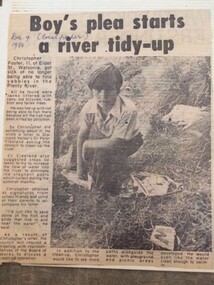
Newspaper Clipping - Digital Image, Boy's plea start Plenty River tidy-up, 09/12/1980
Christopher Foster, age 11, was sick of not being able to find yabbies in the Plenty River. He wrote to a local Councillor and asked that the River be cleaned up.Digital copy of newspaper article, black text and black and white image.plenty river, chris foster -
 Greensborough Historical Society
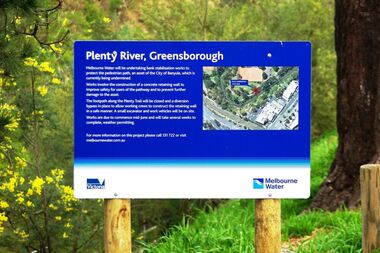
Photograph - Digital image, Marilyn Smith, Plenty River bank stabilisation 2015, 16/08/2015
River bank stabilisation project along the Plenty River at Greensborough 2015, conducted by Melbourne Water. Project sign and close-up of aerial view of site.Digital copy of colour photographplenty river, melbourne water -
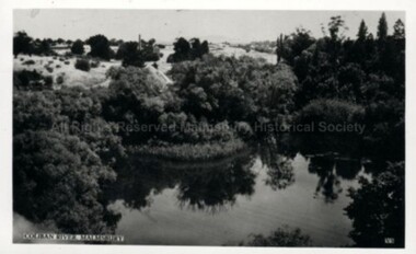
Lakes Entrance Historical Society
Photograph - Snowy River Gorge at Turlock Ard, Rev John Flynn, 1906
Photographic proof on light cardBlack and white photograph of views of Snowy River Gorge at Tulock Ard Gelantipy VictoriaJohyn Flynn Postcards from Buchan P39waterways -
 Lakes Entrance Historical Society
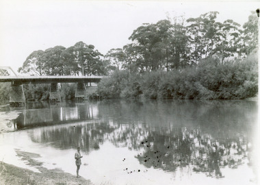
Photograph - Bridges, 1947
Date made February 1947Black and white photograph showing part of the road bridge over there Snowy River, river level low, man in shorts standing at edge of river. Orbost, Victoria.bridges, waterways, recreation -
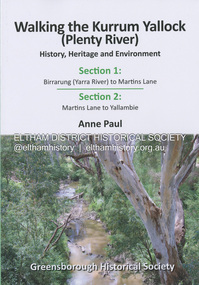 Eltham District Historical Society Inc
Book, Anne Paul, Walking the Kurrum Yallock (Plenty River), 25 July 2023
Kurrum Yallock - the Plenty River is Melbourne's third river. It is a defining feature of the region weaving its way through local suburbs and parklands. It is often hidden from general view, emerging at bridges and along its extensive trail network. While diminished since European settlement, the River provides an important environmental, wildlife corridor and recreational resource, along with many links to its settlement heritage. The Kurrum Yallock walks aim to guide people along the River Trail, while providing insight into key aspects of our recent history, an opportunity for reflection and an enhanced enjoyment of the River's special environment and landscape.birrarung, greensborough historical society, kurrum yallock, martins lane, plenty river, yallambie, yarra river -
 Greensborough Historical Society
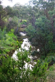
Photograph - Digital Image, Plenty River Greensborough May 2014 -1, 21/05/2014
The Plenty River flows south from Mt Disappointment before meeting with the Yarra River at Rosanna. These images taken in the Greensborough area. Photograph by Marilyn Smith 2014.Digital copy of colour photograph.plenty river, greensborough -
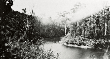
 Marysville & District Historical Society
Photograph (item) - Black and white photograph, Approximately 1944
A black and white photograph taken at the Taggerty River near Marysville. The photograph was taken in about 1944 during a stay at Roseleigh guest house in Marysville.A black and white photograph taken at the Taggerty River near Marysville. The photograph was taken in about 1944 during a stay at Roseleigh guest house in Marysville.Marysville - Taggerty River/ about 1944/ Nancy Duncan 07marysville, victoria, australia, roseleigh guest house, grieve family, thomas charles grieve, john arthur grieve, rose grieve, ackerman family, mary moyne, elise ackerman, ken mcleod, george peters, rose emily pullum, beltana, rose lillian smith, ivy may grieve, alexander james ficinus, raymond charles smith, accommodation, photograph, nancy duncan, taggerty river -
 Ballarat Heritage Services
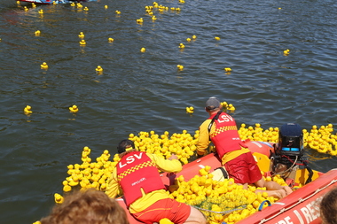
Digital photographs, L.J. Gervasoni, getting the ducks back in the boat, c2013
Colour photograph of the Duck Race on teh Moyne River held on New Year's Day at Port Fairy. landscape, port fairy, beach, waterscape, moyne river, moyneyana, new years day, duck race -
 Federation University Historical Collection
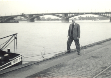
Photograph - Black and White, Frank Wright beside a river
Frank Wright was a renown resident of Smeaton, where he was born. He lived at Laura Villa, and attended Smeaton State School. His father William was a gold miner and his mother's name was Sarah. Their family won many singing and instrumental awards. Frank was tutored by Percy Code and was awarded a gold medal for the highest marks in the ALCM examinations in the British Colonies at the age of seventeen years. He became the Australian Open Cornet Champion by the age of eighteen. A year later, Frank conducted the City of Ballarat Band, and later the Ballarat Soldiers’ Memorial Band. He formed the Frank Wright Frisco Band and Frank Wright and his Coliseum Orchestra. These bands won many South Street awards, and Frank as conductor won many awards in the Australian Band Championship contest. In 1933 Frank Wright sailed to England to conduct the famous St Hilda’s Band and was later appointed Musical Director of the London County Council, where he organized many amazing concerts in parks, in and around the London district. He was made Professor of Brass and Military Band Scoring and conducted at the Guildhall of Music and Drama. Frank was often invited to adjudicate Brass Band Championships around Europe, in Australia, including South Street and in New Zealand. The Frank Wright Medal at the Royal South Street competition is awarded to an individual recognized as making an outstanding contribution to brass music in Australia.This is a black and white photograph of a man standing beside a river along side a boat which is tied to the wharf, the boat is called Reitz. Behind the man is a three spanned arched bridge. The man is Frank Wright.frank wright -
 Malmsbury Historical Society
Photograph (Item), "B/W Coliban River, Malmsbury", Malmsbury c1934
Buildings - Coliban River -
 Malmsbury Historical Society
Photograph (Item), View Of Coliban(?) River (Near Ellis Falls?) At Malmsbury, Malmsbury c1920
Buildings - River (Coliban/?) -
Melbourne Tram Museum
Newspaper, Head of River Boat races, May. 1934
Head of River Boat races Newspaper clipping and table card for tram scheduling for Head of River Boat Races, Thursday 17 May & Friday 18 May 1934: 1 - Newspaper clipping: outlining daily program of races. 490H x 60W, poor condition, torn and folded 2 - Set of 3 pages of handwritten table cards for Head of River Boat Races. Loading Checks on all routes taken at St Kilda and City Rds, Elsternwick, St Kilda Beach, Toorak, South Melbourne & St Kilda Beaches, east Malvern, Glen Iris, Camberwell, east Malvern @ St Kilda Junction. Loading Checks of Batman Avenue Cars, Glenferrie Rd, Swan & Church Sts, Prahran Cars Swan & Church Ststrams, tramways, instructions, events -
 Malmsbury Historical Society
Photograph (Item), B/W Children Swimming In Coliban River, Malmsbury c1934
Buildings - "Coliban River, Mill" -
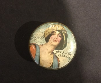 Mont De Lancey
Tin, Bostocks
On Loan from Mrs. K. Bourke c/o Mrs. H. N. LordDecorative round tin with lady on lid.Bostocks - dry suede cleaner. White - 2oz. Contents - Black 1 oz.tins, containers, cleaning products -
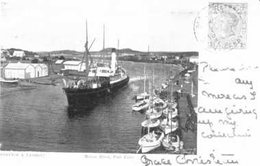 Port Fairy Historical Society Museum and Archives
Photograph - Photographic postcard, S.S.Casino in Moyne River 1905
This postcard features the S.S.Casino steaming into the Moyne river at Port Fairy after turning around in a "turning basin" situated further up the river it would then berth and disembark passengers and cargo onto the wharfPostcard featuring a photograph of S.S.Casino 1904 written on and stampedship, boat, sea, moyne river, s.s.casino, belfast and koroit steam navigation company -
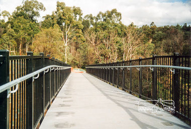 Eltham District Historical Society Inc
Photograph, Doug Orford, Completion of bridge works across Yarra River at rear of Eltham Lower Park, July 2004, July 2004
Brand new Eltham-Templestowe footbridge over the Yarra River off Homestead Road, Eltham which was completed in July 2004. The Yarra River Footbridge was opened in August 2004 and links the Diamond Creek Trail between the Shire of Nillumbik and City of Manningham. It is a shared pathway and also links with the Main Yarra Trail. It affords lovely views over the Yarra River.One of three colour photographs.yarra river, eltham south, eltham lower park, lenister farm, homestead road, shared pathway, diamond creek trail, footbridge -
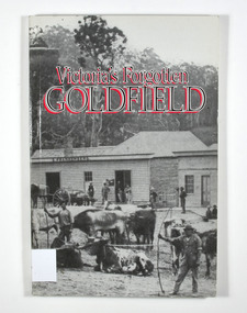 Marysville & District Historical Society
Book - Paperback book, Victoria's Forgotten Goldfield-A History of the Dargo, Crooked River Goldfield, 1996
A history of the Dargo, Crooked River goldfieldPaperback. Cover has a black and white photograph of a couple of buildings surrounded by forest. Photograph is probably of Dargo. One building has a sign that says S. Frankenberg. Another has a sign of which only the letters PION visible. In the photograph there are a number of men standing around the buildings as well as what appears to be two children sitting on a bench outside a building. There is also a large wagon-like vehicle to which is attached are a large train of oxen. In the foreground of the photograph is another group of oxen which appear to be chained together. There is also two men standing near the second group of oxen, both appear to be holding whips.The stamp of the Marysville & District Historical Society Inc / P.O. Box 22 / Marysville 3779gold, gold mining, gold town, dargo, gold miner, gold field, gippsland, victoria, australia, history -
 Malmsbury Historical Society
Postcard (Item), Railway Viaduct Over Coliban River At Malmsbury, Malmsbury ca1940
Buildings - Coliban River & Malmsbury Mill -
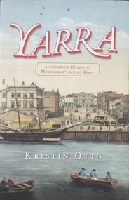 Kew Historical Society Inc
Book, Kristin Otto, Yarra: a diverting history of Melbourne's murky river, 2005
245 p. : ill., bib., index, pbk ; 24 cm.non-fictionmelbourne - history, yarra river - history -
 Stawell Historical Society Inc
Photograph, Wooden Footbridge over the river in Glenorchy
Glenorchy Wooden Footbridge over Riverstawell -
 Wonga Park Community Cottage History Group
Photograph (Item) - Black and White, Wonga Park: A view of the Yarra River
Wonga Park: A view of the Yarra RiverPhoto is named 14880031.jpg on CD -
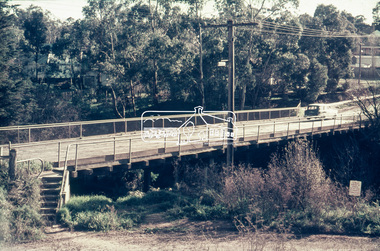 Eltham District Historical Society Inc
Slide - Photograph, Russell Yeoman, Para Road / Carter Street Bridge over the Plenty River, Briar Hill, c.Jul 1969
Bridge over the Plenty River at Briar Hill before widening and alterations. The Plenty River at Briar Hill represented the boundary between the Shire of Eltham and the Shire of Diamond Valley. The bridge was known as the Carter Street Bridge as prior to 1969 Para Road, Briar Hill became Carter Street, Greensborough across the river. It was at this time that the name Para Road was continued and replaced Carter Street.35mm colour positive transparency blue Agfacolour Service plastic mount1969-07, briar hill, carter street bridge, para road, para road bridge, shire of diamond valley, shire of eltham, bridge, plenty river, shire of eltham pioneers photograph collection -
 Eltham District Historical Society Inc
Negative - Photograph, Russell Yeoman, Para Road / Carter Street Bridge over the Plenty River, Briar Hill, c.Jul. 1969
Bridge over the Plenty River at Briar Hill before widening and alterations. The Plenty River at Briar Hill represented the boundary between the Shire of Eltham and the Shire of Diamond Valley. The bridge was known as the Carter Street Bridge as prior to 1969 Para Road, Briar Hill became Carter Street, Greensborough across the river. It was at this time that the name Para Road was continued and replaced Carter Street.This photo forms part of a collection of photographs gathered by the Shire of Eltham for their centenary project book,"Pioneers and Painters: 100 years of the Shire of Eltham" by Alan Marshall (1971). The collection of over 500 images is held in partnership between Eltham District Historical Society and Yarra Plenty Regional Library (Eltham Library) and is now formally known as the 'The Shire of Eltham Pioneers Photograph Collection.' It is significant in being the first community sourced collection representing the places and people of the Shire's first one hundred years.Digital image 35 mm B&W negativeshire of eltham pioneers photograph collection, briar hill, 1969-07, bridge, carter street bridge, para road, para road bridge, plenty river, shire of diamond valley, shire of eltham