Showing 15144 items matching "view"
-
 Eltham District Historical Society Inc
Photograph - Digital Photograph, Jim Connor, View looking west along Luck Street from near Commercial Place,. Eltham, 18 April 2018
Former McEwans the Bunnings builing on right, now Aldijim connor collection, eltham shopping centre, luck street -
 Eltham District Historical Society Inc
Slide, View of Thomas Street from intersection with Frank Street, Eltham, Nov. 1981
Roll of film taken by Eltham Shire Council officers (Nov. 1981) of the Beard street group, a private street scheme, before construction commenced in February 1982. They provide perspective of the changes in housing styles and road development that began sweeping in from the mid 1970s with increasing urbanisation of what was once more outlying suburbs and regions.35 mm colour positive transparency (1 of 27) Mount - Kodak Ektachrome CardProcessed 18 Jan 1982roads, housing estate, infrastructure, private street scheme, eltham, frank street, thomas street -
 Eltham District Historical Society Inc
Slide - Photograph, View looking down Luck Street towards Main Road, Eltham, c.Dec. 1987
The former Franklins and McEwans building is on the left. It then became Bunnings before they built a new store in Bridge Street and is presently a Dan Murphy and Aldi store and other smaller stores. The focus for Eltham Shire Council officers in this image is the significant littering concern.35mm colour positive transparency (1 of 7) Mount - Kodak Kodachrome CardProcess Date JUN 86Mroads, infrastructure, litter, luck street, mcewans, franklins, franklins supermarket -
 Eltham District Historical Society Inc
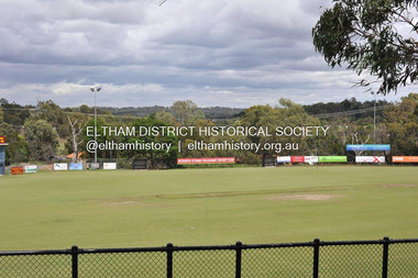
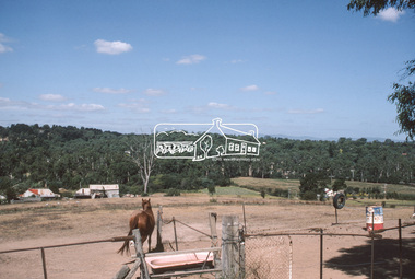
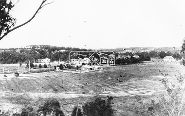
Photograph, Barry Philp, View towards Eltham from Research Oval, c.1969
Taken from Cricket Club oval, looking down the Hill towards Elthamresearch (vic.), eltham, main road, research cricket club, research oval -
 Eltham District Historical Society Inc
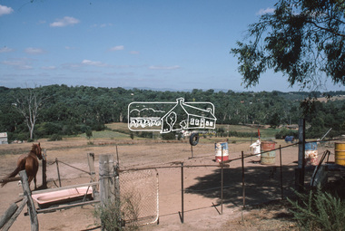
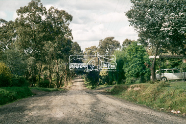
Photograph, Barry Philp, View towards Eltham from Research Oval, c.2013
Taken from Cricket Club oval, looking down the Hill towards Elthamresearch (vic.), eltham, main road, research cricket club, research oval -
 Eltham District Historical Society Inc
Photograph, Barry Philp, View from Research, c.1969
research (vic.), power transmission lines -
 Eltham District Historical Society Inc
Photograph, Doug Orford, View from former Caretaker's Cottage, Garden Hill, Kangaroo Ground, 1985, 1985
At Kangaroo Ground Memorial TowerRoll of 35mm colour negative film, 7 stripsFuji 100Nkangaroo ground, caretaker cottage, garden hill farm, war memorial tower -
 Eltham District Historical Society Inc
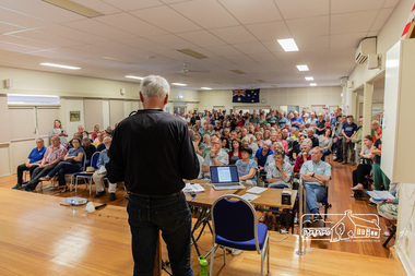
Photograph, Peter Pidgeon, Greg Johnson moves a motion to present to Council the community's view regarding the proposed land sale/development; Eltham Community Town Hall Meeting, Eltham Senior Citizen's Centre, 13 October 2018, 13 Oct 2018
Community meeting held at the Eltham Senior Citizen's Centre to discuss Nillumbik Shire Council's advertised proposal to sell the former Shire Office site at 895 Main Road and the Eltham War Memorial complex of buildings at 903-907 Main Road; 13 October 2018Born digital image895 main road, 903-907 main road, community meeting, eltham pre-school, eltham shire office, eltham war memorial, eltham war memorial hall, infant welfare centre, nillumbik shire council, senior citizen's centre -
 Eltham District Historical Society Inc
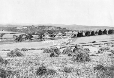
Photograph, View at Kangaroo Ground, c.1908
Reproduced on p19 of 'Pioneers & Painters' Source: Mrs Ferguson, HurstbridgeThis photo forms part of a collection of photographs gathered by the Shire of Eltham for their centenary project book,"Pioneers and Painters: 100 years of the Shire of Eltham" by Alan Marshall (1971). The collection of over 500 images is held in partnership between Eltham District Historical Society and Yarra Plenty Regional Library (Eltham Library) and is now formally known as the 'The Shire of Eltham Pioneers Photograph Collection.' It is significant in being the first community sourced collection representing the places and people of the Shire's first one hundred years.Digital imagekangaroo ground, pioneers and painters, sepp, shire of eltham pioneers photograph collection, hay, farm -
 Eltham District Historical Society Inc
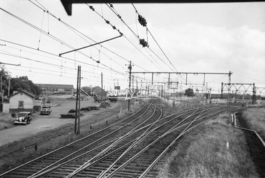
Photograph, George Coop, View looking south from the Newport Signal Box, Newport Railway Station, c.1951
The pair of lines running to trhe left head to Williamstown. the central pair of lines are heading into the Newport Workshops and various stored trains are visible in the background and the pair of lines diverging to the right are heading to Geelong. One of several photos at Newport taken the same day in the early 1950s when George Coop was a secondary school student.Digital TIFF file Scan of Kopdak 620 black and white negative transparencygeorge coop collection, newport railway station, newport signal box -
 Eltham District Historical Society Inc
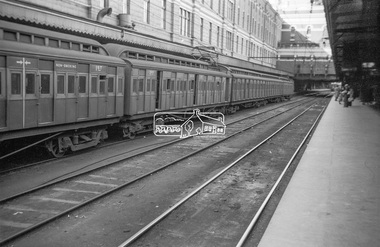
Photograph, George Coop, View of Tait Red Rattler at No. 1 Platform, Flinders Street Railway Station, Sep. 1954
Most likjely taken either arriving or departing from a visit of the display at Spencer Street Railway Station during the 1954 Victorian Railways Centenary Exhibition, 11-25 Sep. 1954 "V.R. Cavalcade" Centenary 1854-1954 Exhibition (11-25 Sep 1954) presented a model railway occupying about 1,400 square feet in the Lower Town Hall featuring a number of model railway working scale models. The exhibition also included a display of rolling stock, track, electrical and other railway equipment held at Spencer Street Railway Station.Digital TIFF file Scan of Kopdak 620 black and white negative transparencygeorge coop collection, v.r. cavalcade, victorian railways centenary 1854-1954 exhibition, red rattler, tait train -
 Eltham District Historical Society Inc
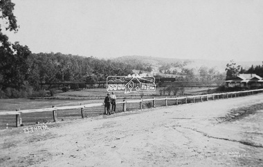
Photograph (item), J.H. Clark, View of Eltham from Main Road, c.1907
An F-class 2-4-0 steam locomotive and tender hauls a train of two open wagons, a guards van and a single Tait passenger car over the Eltham Railway Trestle Bridge, heading for Melbourne. This type of steam locomotive was replaced by the F-Class 2-4-2. The house on the right, originally known as 'Derril' was purchased in the early 1920s by Walter Ernest and Alice Miriam Gahan. On the western side of Main Road near the present-day site of Shillinglaw Cottage, they remained till about 1960 when Walter died. The house was demolished in 1968 during the widening of Main Road. In the distance beyond the trestle bridge on what would become Central Park appears to be an orchard of fruit trees. A young man with waist coat, jacket and hat stands beside an older man wearing suspenders without jacket and bare headed, sitting on the post fence. Photographer: J.H. Clark John Henry Clark was the youngest of three boys born to William Henry Clark (1823-1877) and Maria White (1843-1914). He and his brothers, William Charles Clark (1872-1945), Clement Kent Clark (1874-1912) operated a photography business (Clark Bros.) from 25 Thomas Street, Windsor near Prahran during the period c.1894 to 1914. Following death of Clement in September 1912 and their mother in 1914, the Clark Bros business appears to have dissolved, the premises demolished, and a new house was under construction in 1915. John set up business independently in 1914 operating out of 29 Moor Street, Fitzroy where he is registered in the 1914 and 1915 Electoral Rolls. By 1916 John had relocated to Eltham where he continued his practice as a photographer and took many of the early images around the district of Little Eltham. Around 1930 John changed professions and opened a small cobbler's shop in 1931 near the pond opposite Dalton Street adjacent to the Jarrold family cottage. He never married and continued his profession as a bootmaker from this little shop, maintaining a close relationship with Mrs Jarrold for the rest of their lives. His bootmaker shop remains today beside the Whitecloud cottage and is one of only three remaining shops in the area from the early 20th century. There are a couple of images of Eltham taken by Clark Bros. in the Eltham District Historical Society collection, one such example being Hunniford’s Post Office with Miss Anne Hunniford out front (EDHS_00140 - marked on the back of the print, Clark Bros., 25 Thomas St. Windsor), which would date this image between c.1894 and 1914. Other early images of Eltham taken by John Henry Clark are marked on the face “J. H. Clark Photo” and it is assumed these are dated between 1914 and 1930. It is noted that the Grant of Probate for John H Clark of Eltham South dated 5 April !957 (513/387) records his occupation as "X Photographer".derril, eltham railway trestle bridge, f-class 2-4-0 steam locomotive, gahan house, j.h. clark photo, main road, orchards, postcards, steam train, tait train, victorian railways -
 Eltham District Historical Society Inc
Slide, View looking northeast to turnabout near 10 McCarthy Grove, Montmorency, c.Oct. 1980
One of a series of images of roads and infrastructure taken by Eltham Shire Council Planning and Engineering officers. They provide perspective of the changes in housing styles and road development that began sweeping in from the mid 1970s with increasing urbanisation of what was once more outlying suburbs and regions.35 mm colour positive transparency Mount - Kodak Kodachrome CardProcessed Oct 1980houses, infrastructure, mccarthy grove, montmorency, roads -
 Eltham District Historical Society Inc
Slide, View looking southwest to turnabout near 9 McCarthy Grove, Montmorency, c.Oct. 1980
One of a series of images of roads and infrastructure taken by Eltham Shire Council Planning and Engineering officers. They provide perspective of the changes in housing styles and road development that began sweeping in from the mid 1970s with increasing urbanisation of what was once more outlying suburbs and regions.35 mm colour positive transparency Mount - Kodak Kodachrome CardProcessed Oct 1980houses, infrastructure, mccarthy grove, montmorency, roads -
 Eltham District Historical Society Inc
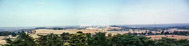
Slide - Photograph, View of Melbourne from Shire of Eltham War Memorial tower, Kangaroo Ground, c. 1988
35mm colour positive transparency (x3) Mount - Black and White Digital panorama stitched from three imageskangaroo ground, shire of eltham war memorial, war memorial tower -
 Eltham District Historical Society Inc
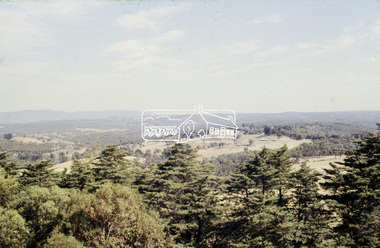
Slide - Photograph, View from Shire of Eltham War Memorial tower at Kangaroo Ground, c. Feb. 1989
35mm colour positive transparency (1 of 8) Mount - Agfa CS System grey 8 dotskangaroo ground tower, shire of eltham war memorial -
 Eltham District Historical Society Inc
Slide - Photograph, View from Porter Street, Eltham, c.Mar. 1989
35mm colour positive transparency (1 of 28) Mount - Kodak KodachromeProcess Date MAR 89Meltham, porter street, porter street reserve -
 Eltham District Historical Society Inc
Slide - Photograph, View from Porter Street, Eltham, c.Mar. 1989
35mm colour positive transparency (1 of 28) Mount - Kodak KodachromeProcess Date MAR 89Meltham, porter street, porter street reserve -
 Eltham District Historical Society Inc
Slide - Photograph, Northeast view from near 68 Porter Street, Eltham, c.Nov. 2001
Part of a slide show presentation "A Trip Down the Diamond Creek" by Russell Yeoman to the Eltham District Historical Society meeting of 14 Nov. 200135mm colour positive transparency Mount - Black and Whiteeltham, porter street -
 Eltham District Historical Society Inc
Slide - Photograph, Southeast view from near 60 Porter Street, Eltham, c.Nov. 2001
Part of a slide show presentation "A Trip Down the Diamond Creek" by Russell Yeoman to the Eltham District Historical Society meeting of 14 Nov. 200135mm colour positive transparency Mount - Black and Whiteeltham, porter street -
 Eltham District Historical Society Inc
Work on paper (Sub-Item) - Photograph, The Kinglake escarpment. View from Bald Spur lookout across Arthurs Creek to Mount Sugarloaf, 1980
kinglake, blad spur, arthurs creek, mount sugarloaf -
 Eltham District Historical Society Inc
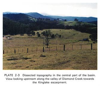
Work on paper (Sub-Item) - Photograph, Dissected topography in the central part of the Diamond Creek basin. View looking upstream along the valley of Diamond Creek towards the Kinglake escarpment
kinglake, escarpment -
 Eltham District Historical Society Inc
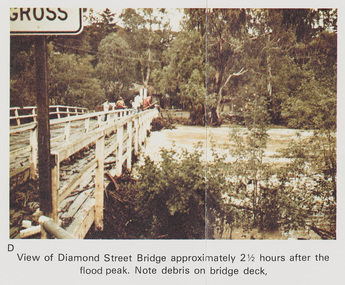
Work on paper (Sub-Item) - Photograph, Flooding, View of Diamond Street Bridge, Eltham 8 April 1977
Colour photograph. Flooding of Diamond Creek at Diamond Street Eltham bridge approximately 2 1/2 hours after the flood peak. Note debris on the bridge deck. 8 April 1977. flood, diamond creek, flooding, eltham, diamond street, bridge -
 Eltham District Historical Society Inc
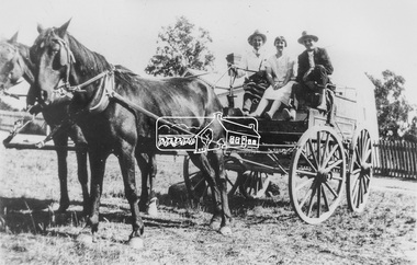
Photograph, View of two men wearing hats with a young woman seated in between on a cart harnessed to two horses, possibly Diamond Creek and Hurstbridge district, c.1920
Black and white copy of photo printed on glossy photographic paper 30.5 x 40.5 cm (12 x 16 inch); image size approx. 18.5 x 28 cmdiamond creek, groups, horse, horse drawn carriage, hurstbridge -
 Eltham District Historical Society Inc
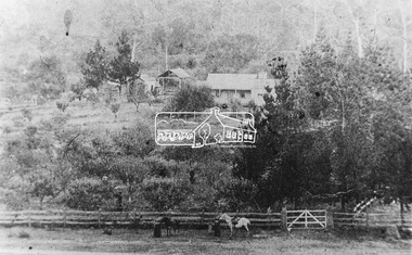
Photograph, Elevated view of farmhouse and buildings, possibly Diamond Creek and Hurstbridge district, c.1900
Black and white copy of photo printed on glossy photographic paper 30.5 x 40.5 cm (12 x 16 inch); image size approx. 18.5 x 28 cmdiamond creek, farm-buildings, fences, horse, hurstbridge -
 Eltham District Historical Society Inc
Photograph, Elevated view, most likely of Hursbridge, c.1910
Black and white copy of photo printed on glossy photographic paper 30.5 x 40.5 cm (12 x 16 inch); image size approx. 18.5 x 28 cmhurstbridge -
 Eltham District Historical Society Inc
Photograph, Baldwin Avenue from Mountain View Road, Montmorency, c.1972, 1972c
Shire of Eltham road construction and realignment works on Baldwin Avenue, Lilicur Road and Price Avenue, Montmorency, c.197235mm colour positive transparency blue Agfacolour Service plastic mountbaldwin avenue, infrastructure, mountain view road, road construction -
 Eltham District Historical Society Inc
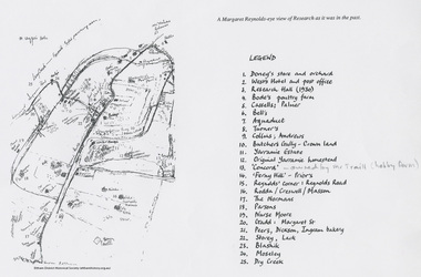
Document - Map, Margaret Reynolds, A Margaret Reynolds-eye view of Reseach as it was in the past, 1989
Reproduced in Return to Research : a centenary history of Research Primary School / edited by Andrew LemonA4 photocopy andrews, bell, blashik, bode's poultry farm, butchers gully, cassells, collins, concord, creswell, dickson, doney's store, dry creek, ferny hill, gadd, ingram bakery, lack, margaret reynolds, margaret street, maroondah aqueduct, masson, moseley, normans, nurse moore, palmer, parsons, peers, prior, research (vic.), research hall, reynolds corner, reynolds road, rodda, storey, traill property, turner, west's hotel, yarramie estate -
 Eltham District Historical Society Inc
Photograph, View looking up 'Policeman's Hill' on Main Road from Dalton Street showing Police Residence, c.1906, 2010c
For original image see EDHS_00533 This photo was originally mounted on 3mm MDF fibre board with notes and stickers applied as part of a display on the former Police Residence and now present day Local History Centre, home to Eltham District Historical Society; possibly put together by Harry Gilham during his time as president of the society. Eltham Police Station and Residence: A brief history 1860 Eltham Courthouse built in Main Road, together with an adjoining police residence, office, lock–up and stables. 1959 Police Department purchases a house in Pryor Street to be refurbished as Eltham Police Station 1961 Police in Eltham move into Pryor Street refurbished buildings and office. c.1961-1981 Occupied by Vermin and Noxious Weeds Destruction Section of the Department of Crown Lands and Survey. Former Police Station dragged around to rear of Police Residence (prior to August 1967) to make way for the construction of a driveway and access from Main Road. The building was placed on the site of a former Scullery and modified for Lands Department use. 1981 Shire of Eltham take over management of old Police Residence in Eltham. It remains unoccupied for a period of time whilst its future is discussed in Council. 1981-1985 Used for community job creation scheme 1985 Shire of Eltham Parks and Environment occupy the residence. Council improve the driveway but later add a second rear access from Brougham Street due to the dangerous nature of the Main Road entrance. Also add a rear toilet facility between the Police Residence and former Police Station, which was doubling up as a lunch room. Council also commence discussions to re-establish a replica Police Station. c.1986 November. Former Police Station demolished; believed to have been suffering termite damage. c.1989 After some years of discussion a replica Police Station is built, based on photographs, to act as a lunch room and meeting room for Parks and Environment staff and volunteers doing community service. 1996 Eltham District Historical Society in discussions with Nillumbik Shire Council commisioners throughout the year regarding a home for the Society. A proposal put forward by the Society in October to occupy the former Police Residence. 1997 March. Eltham District Historical Society gains access to former Police Residence. 1998 July 12th. Eltham District Historical Society Inc moves into its Local History Centre, 728 Main Road Eltham (the former Police Residnce built in 1860). 2018 July. Eltham District Historical Society gains access to the replica Police Station for use as part of regular heritage tours for schools and community based groups.Black and white photocopyLabels and handwriting in pencil and ink identifying various buildings. Also highlighted is the acetylene gas lamp and on reverse is written "Lamplighter Jimm Saville"728 main road, eltham, local history centre, parks and environment, police residence, police station, shire of eltham -
 Eltham District Historical Society Inc
Slide, View of Martin's house indicating its relationship to the gully, Bonds Road, Lower Plenty, 18 July 1972, 1972
Water drainage work undertaken by Eltham Shire Council in Bonds Road, Lower Plenty outside the Martin property opposite Montpelier Drive, July 1972 35 mm colour positive transparency Mount - Agfacolor Service (Blue)Bonds Road (Martin property) 12.10 pm 18.7.72bonds road, drainage works, eltham shire council, infrastructure, lower plenty, martin property, montpelier drive