Showing 70902 items
matching melbourne street
-
 Greensborough Historical Society
Map, Melbourne and Metropolitan Board of Works. Survey Division, MMBW, Yarra 2500 / 12.23. Janefield and Kangaroo Point, 1977_10
Melbourne and Metropolitan Board of Works. Yarra 2500 [base map] 12-23, Municipalities of Whittlesea 239 and Diamond Valley 257. No streets marked on this map. Includes Plenty River, Kangaroo Point, Janefield Colony and Janefield Reserve.MMBW Map in 1:2500 [scale] series. Cream parchment with green tape reinforcing on edges and punched holes on left edge.mmbw, melbourne and metropolitan board of works, shire of diamond valley, plenty - maps -
 Greensborough Historical Society
Map, Melbourne and Metropolitan Board of Works. Survey Division, MMBW, Yarra 2500 / 13.19. Lower Plenty, Montmorency, Yallambie, 1979_02
Melbourne and Metropolitan Board of Works. Yarra 2500 [base map] 13-19. Lower Plenty, Montmorency, Yallambie. Parishes of Keelbundora 2856 and Nillumbik 3310. Municipalities of Heidelberg 228, Diamond Valley 257 and Eltham 238. Prominent streets include: Elder Street, Para Road, and Main Road Lower Plenty. Includes Watsonia Army Barracks.MMBW Map in 1:2500 [scale] series. Cream parchment with green tape reinforcing on edges and punched holes on left edge.mmbw, melbourne and metropolitan board of works, shire of diamond valley, montmorency - maps, yallambie - maps, lower plenty - maps -
 Greensborough Historical Society
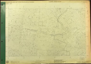
Map, Melbourne and Metropolitan Board of Works. Survey Division, MMBW, Yarra 2500 / 13.20. Greensborough, Montmorency and Watsonia, 1979_03
Melbourne and Metropolitan Board of Works. Yarra 2500 [base map] 13-20. Greensborough, Montmorency and Watsonia. Parishes of Nillumbik 3310 and Keelbundora 2856. Municipalities of Eltham 238 and Diamond Valley 257. Prominent streets include: Nell Street, Nepean Street and Alexandra Street. Includes Montmorency High School.MMBW Map in 1:2500 [scale] series. Cream parchment with green tape reinforcing on edges and punched holes on left edge.mmbw, melbourne and metropolitan board of works, shire of diamond valley, greensborough - maps, montmorency - maps, watsonia - maps -
 Greensborough Historical Society
Map, Melbourne and Metropolitan Board of Works. Survey Division, MMBW, Yarra 2500 / 13.22. Greensborough, Apollo Parkways, 1979_06
Melbourne and Metropolitan Board of Works. Yarra 2500 [base map] 13-22. Greensborough, Apollo Parkways. Parishes of Nillumbik 3310 and Keelbundora 2856. Municipalities of Diamond Valley 257 and Whittlesea 239. Prominent streets include: Plenty River Drive, Diamond Creek Road and Civic Drive. Includes Diamond Valley Civi Centre, Churinga, Janefield Colony Reserve and "proposed freeway" now Greensborough Highway (Bypass)MMBW Map in 1:2500 [scale] series. Cream parchment with green tape reinforcing on edges and punched holes on left edge.mmbw, melbourne and metropolitan board of works, shire of diamond valley, greensborough - maps, apollo parkways - maps -
 Greensborough Historical Society
Map, Melbourne and Metropolitan Board of Works. Survey Division, MMBW, Yarra 2500 / 13.23. Plenty, Happy Hollow, 1979_03
Melbourne and Metropolitan Board of Works. Yarra 2500 [base map] 13-23. Plenty / Happy Hollow. Parishes of Morang 3183, Nillumbik 3310 and Keelbundora 2856. Municipalities of Diamond Valley 257 and Whittlesea 239. Prominent streets include: McLaughlans Lane and Happy Hollow Drive. Includes Janefield Colony Reserve.MMBW Map in 1:2500 [scale] series. Cream parchment with green tape reinforcing on edges and punched holes on left edge.mmbw, melbourne and metropolitan board of works, shire of diamond valley, plenty - maps, happy hollow -
 Greensborough Historical Society
Map, Melbourne and Metropolitan Board of Works. Survey Division, MMBW, Yarra 2500 / 17.26. Hurstbridge, 1978_01
Melbourne and Metropolitan Board of Works. Yarra 2500 [base map] 17-26. Hurstbridge. Municipalities of Diamond Valley 257 and Eltham 238. Prominent streets include: Flat Rock Road and Heather Avenue. Includes Hurstbridge Railway Station.MMBW Map in 1:2500 [scale] series. Cream parchment with green tape reinforcing on edges and punched holes on left edge.mmbw, melbourne and metropolitan board of works, shire of diamond valley, hurstbridge - maps -
 Greensborough Historical Society
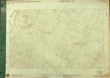
Map, Melbourne and Metropolitan Board of Works. Survey Division, MMBW, Yarra 2500 / 17.25. Hurstbridge, 1978_01
Melbourne and Metropolitan Board of Works. Yarra 2500 [base map] 17-26. Hurstbridge. Municipalities of Diamond Valley 257 and Eltham 238. Prominent streets include: Silvan Road and Hurstbridge Road. MMBW Map in 1:2500 [scale] series. Cream parchment with green tape reinforcing on edges and punched holes on left edge.mmbw, melbourne and metropolitan board of works, shire of diamond valley, hurstbridge - maps -
 Greensborough Historical Society
Map, Melbourne and Metropolitan Board of Works. Survey Division, MMBW, Yarra 2500 / 17.27. Central Hurstbridge, 1978_02
Melbourne and Metropolitan Board of Works. Yarra 2500 [base map] 17-27. Central Hurstbridge. Parish of Greensborough 2724, Municipalities of Diamond Valley 257, Eltham 238 and Whittlesea 239. Prominent streets include: Anzac Avenue and Hurstbridge-Arthurs Creek Road. MMBW Map in 1:2500 [scale] series. Cream parchment with green tape reinforcing on edges and punched holes on left edge.mmbw, melbourne and metropolitan board of works, shire of diamond valley, hurstbridge - maps -
 Greensborough Historical Society
Map, Melbourne and Metropolitan Board of Works. Survey Division, MMBW, Yarra 2500 / 11.22. Bundoora, 1979_01
Melbourne and Metropolitan Board of Works. Yarra 2500 [base map] 11-22. Bundoora. Parish of Keelbundoora 2856, Municipalities of Diamond Valley 257 and Whittlesea 239. Prominent streets include: Greenhills Road, Cabernet Crescent and Plenty Road. Includes Parade College (Christian Brothers) and "proposed future freeway" (now Metropolitan Ring Road)MMBW Map in 1:2500 [scale] series. Cream parchment with green tape reinforcing on edges and punched holes on left edge.mmbw, melbourne and metropolitan board of works, shire of diamond valley, bundoora - maps -
 Greensborough Historical Society
Map, Melbourne and Metropolitan Board of Works. Survey Division, MMBW, Yarra 2500 / 11.21. Bundoora, east of Plenty Road, 1979_01
Melbourne and Metropolitan Board of Works. Yarra 2500 [base map] 11-21. Bundoora, east of Plenty Road. Parish of Keelbundoora 2856, Municipalities of Diamond Valley 257, Preston 225 and Whittlesea 239. Prominent streets include: Grimshaw Street, Settlement Road and Plenty Road. Includes Yulong Park.MMBW Map in 1:2500 [scale] series. Cream parchment with green tape reinforcing on edges and punched holes on left edge.mmbw, melbourne and metropolitan board of works, shire of diamond valley, bundoora - maps -
 Greensborough Historical Society
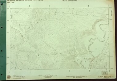
Map, Melbourne and Metropolitan Board of Works. Survey Division, MMBW, Yarra 2500 / 16.25. Wattle Glen, 1978_07
Melbourne and Metropolitan Board of Works. Yarra 2500 [base map] 16-25. Wattle Glen. Municipalities of Diamond Valley 257 and Eltham 238. Prominent streets include: Nimmo Road, Broad Gully Road and Heidelberg-Kinglake Road. Includes Yulong Park.MMBW Map in 1:2500 [scale] series. Cream parchment with green tape reinforcing on edges and punched holes on left edge.mmbw, melbourne and metropolitan board of works, shire of diamond valley, wattle glen - maps -
 Greensborough Historical Society
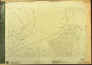
Map, Melbourne and Metropolitan Board of Works. Survey Division, MMBW, Yarra 2500 / 16.24. Northern Diamond Creek and Wattle Glen, 1978_02
Melbourne and Metropolitan Board of Works. Yarra 2500 [base map] 16-24. Northern Diamond Creek and Wattle Glen. Parishes of Nillumbik 3310 and Greensborough 2724. Municipalities of Diamond Valley 257 and Eltham 238. Prominent streets include: Hurstbridge Road, and Reynolds Road. Includes Wattle Glen Station.MMBW Map in 1:2500 [scale] series. Cream parchment with green tape reinforcing on edges and punched holes on left edge.mmbw, melbourne and metropolitan board of works, shire of diamond valley, wattle glen - maps, diamond creek - maps -
 Greensborough Historical Society
Map, Melbourne and Metropolitan Board of Works. Survey Division, MMBW, Yarra 2500 / 16.23. Diamond Creek, 1978_02
Melbourne and Metropolitan Board of Works. Yarra 2500 [base map] 16-23. Diamond Creek. Parish of Nillumbik 3310. Municipalities of Diamond Valley 257 and Eltham 238. Prominent streets include: Phipps Crescent, Bishop Avenue, and Reynolds Road. Includes the former Diamond Creek Technical School.MMBW Map in 1:2500 [scale] series. Cream parchment with green tape reinforcing on edges and punched holes on left edge.mmbw, melbourne and metropolitan board of works, shire of diamond valley, diamond creek - maps -
 Greensborough Historical Society
Map, Melbourne and Metropolitan Board of Works. Survey Division, MMBW, Yarra 2500 / 16.22. Research, 1979_05
Melbourne and Metropolitan Board of Works. Yarra 2500 [base map] 16-22. Research. Parish of Nillumbik 3310. Municipalities of Diamond Valley 257 and Eltham 238. Prominent streets include: Orme Road and Allendale Road. MMBW Map in 1:2500 [scale] series. Cream parchment with green tape reinforcing on edges and punched holes on left edge.mmbw, melbourne and metropolitan board of works, shire of diamond valley, diamond creek - maps -
 Greensborough Historical Society
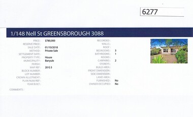
Advertising Leaflet, Barry Plant Greensborough, 1/148 Nell Street Greensborough, 01/10/2018
Real estate advertisement for 1/148 Nell Street Greensborough, a 3 bedroom house. Originally listed with Barry Plant, this house was sold on 30/10/2018 for $780,000 by Flannagan Peressini and Shaw. Previous sales: 06/07/2011 for $420,000; July 1996 $95,000 and April 1993 for $110,000. Real estate advertisement black text and colour photographnell street greensborough -
 Greensborough Historical Society
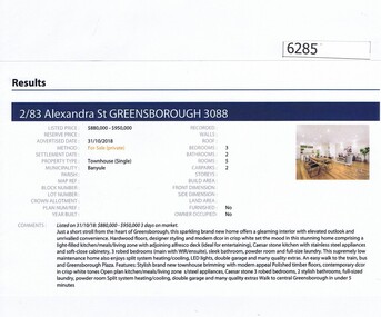
Advertising Leaflet, Barry Plant Greensborough, 2/83 Alexandra Street Greensborough, 31/10/2018
Real estate advertisement for 2/83 Alexandra Street Greensborough, a 3 bedroom townhouse. Originally listed by Barry Plant, this house was for private sale in February 2019 with Buckingham and Co for $925,000. Previous sales: March 2017 for $800,000 Real estate advertisement black text and colour photographalexandra street greensborough -
 Greensborough Historical Society
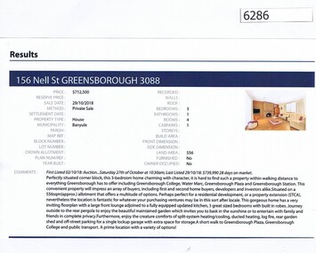
Advertising Leaflet, Barry Plant Greensborough, 156 Nell Street Greensborough, 29/10/2018
Real estate advertisement for 156 Nell Street Greensborough, a 3 bedroom house. This house was sold on 29/10/2018 for $713,000. Real estate advertisement black text and colour photographnell street greensborough -
 Greensborough Historical Society
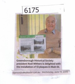
Newspaper Clipping, Greensborough Historical Society, 19/06/2019
Greensborough Historical Society president Noel Withers is delighted with the installation of 13 plaques in Main St.News article 1 page, black text.greensborough historical society, noel withers, main street greensborough -
 Greensborough Historical Society
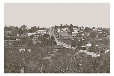
Photograph - Digital Image, Greensborough, looking up Main Street, 1950c
Greensborough in the 1950s, looking towards Main Street from Greenhills.Digital copy of black and white photographmain street greensborough -
 Greensborough Historical Society
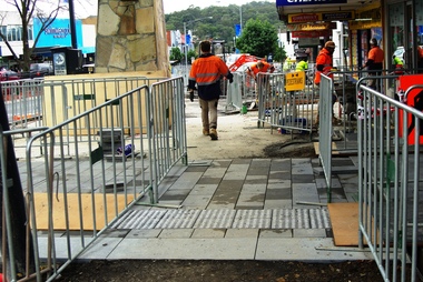
Photograph - Digital Image, Marilyn Smith, Main Street Greensborough, installation of new footpath, 24/06/2018
Installation of new footpath on Plaza side of Main Street GreensboroughDigital copy of colour photographmain street greensborough -
 Greensborough Historical Society
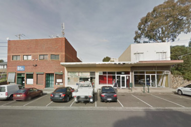
Photograph - Digital Image, Marilyn Smith, Louis Street shops Greensborough, 2014-2018
The redevelopment of the Louis Street Greensborough shopping strip. Photograph 1 taken June 2014, photo 2 taken July 2016 and photos 3 and 4 taken January 2018.Digital copies of 4 colour photographslouis street greensborough -
 Greensborough Historical Society
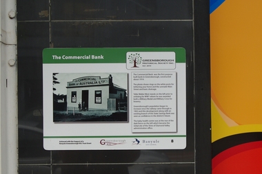
Photograph - Digital Image, Main Street Plaques: Commercial Bank, 18/06/2018
Historical Plaques in the Greensborough shopping strip. The Commercial Bank was the first purpose-built bank in Greensborough. It stood near the current (2019) site of LaPorchetta in Main Street. Further information available on GHS website.The Main Street Plaques Project was undertaken by Greensborough Historical Society and made possible with a grant from the Greensborough RSL.Digital copies of 2 colour photographsmain street greensborough, main street plaques project -
 Greensborough Historical Society
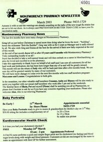
Newsletter, Montmorency Pharmacy Newsletter March 2003, 2003_3
General news about staff at the Montmorency Pharmacy and an article on coeliac disease.1 page newsletter, black text on green paper.montmorency pharmacy, were street montmorency -
 Greensborough Historical Society
Newsletter, Montmorency Pharmacy Newsletter June 2003, 2003_6
General news about staff at the Montmorency Pharmacy and articles on the role of the pharmacist and high blood pressure.1 page newsletter, black text on blue paper.montmorency pharmacy, were street montmorency -
 Greensborough Historical Society
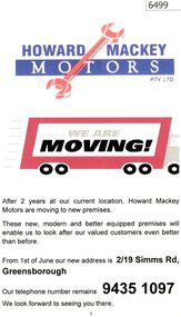
Advertising Leaflet, Howard Mackey Motors Pty Ltd, 2010c
Notification to customers that Howard Mackey Motors Pty Ltd are moving from Binns Street to 19 Simms Road Montmorency.I page advertising leaflet, lack text, blue and red images on white paper.howard mackey motors, simms road montmorency, binns street montmorency -
 Greensborough Historical Society
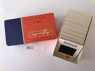
Photographic Slides, Watsonia High School Pool - Photo Slides 1968, 1976-1977
Records the development of the Watsonia High Pool at the Nepean Street Greensborough site during the years 1976-1977. The pool is still operational in 2019 as Yarra Swim School.Primary source material of the beginnings of the pool.36 Kodak slides of in Agfacolor box."Handwritten on box: Watsonia High 2-5-68 H.N." printed on slides: "Processed by Kodak - Ektachrome Transparency".watsonia high school, kodak slides, yarra swim school -
 Greensborough Historical Society
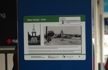
Photograph - Digital Image, Main Street Plaques: Main Street 1923, 18/06/2018
Historical Plaques in the Greensborough shopping strip. The view of Main Street Greensborough in 1923. This photograph was taken from near the current (2019) site of the Plaza entrance in Main Street. Further information available on GHS website.The Main Street Plaques Project was undertaken by Greensborough Historical Society and made possible with a grant from the Greensborough RSL.Digital copy colour photographmain street greensborough, main street plaques project -
 Greensborough Historical Society
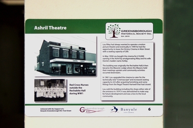
Photograph - Digital Image, Main Street Plaques: Ashril Theatre, 18/06/2018
Historical Plaques in the Greensborough shopping strip. The Ashril Theatre in Main Street Greensborough. This Theatre stood near the current (2019) site of the Plaza entrance in Main Street. Further information available on GHS website.The Main Street Plaques Project was undertaken by Greensborough Historical Society and made possible with a grant from the Greensborough RSL. Digital copy colour photographmain street greensborough, main street plaques project, ashril theatre -
 Greensborough Historical Society
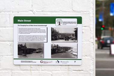
Photograph - Digital Image, Main Street Plaques: The changing face of Main Street, 18/06/2018
Historical Plaques in the Greensborough shopping strip. The changing face of Main Street Greensborough. This group of photographs shown Main Street roughly from the current (2019) site of Pelligra Cakes in Main Street. Further information available on GHS website.The Main Street Plaques Project was undertaken by Greensborough Historical Society and made possible with a grant from the Greensborough RSL. Digital copy of colour photographmain street greensborough, main street plaques project -
![Envelope, Montmorency Pharmacy [photo processing envelope], 1996_](/media/collectors/4f729f5697f83e03086015b8/items/5d14353b21ea940d440b0e1e/item-media/5d15ac0421ea72137400c541/item-fit-380x285.jpg) Greensborough Historical Society
Greensborough Historical SocietyEnvelope, Montmorency Pharmacy [photo processing envelope], 1996_
Produced for Montmorency Pharmacy, 45 Were Street Montmorency 3094. Rolls of film were placed in the envelope and sent off to be processed; completed prints were returned to the outlet in the same envelope. Photograph print envelope used by Montmorency Pharmacy; printed in black, blue, red and yellow, both sidesGuardian Family Chemist, serial numbers and bar codes; glossy 10 cm prints marked as ordered, customer telephone number, price and date handwrittenmontmorency pharmacy, photography