Showing 111523 items matching " road"
-
 Whitehorse Historical Society Inc.
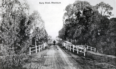
Photograph - Black and white photograph, Surrey Road Blackburn
Used by donor in 'Blackburn - a picturesque history'Black & white photo of Surry (sic) Road Blackburn (captioned) Surrey Roadsurrey road, blackburn, surry road bridge -
 Whitehorse Historical Society Inc.
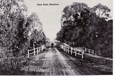
Photograph, Surrey Road, Blackburn
Black and white photo of Surrey road, Blackburn (captioned Surry Road (sic))blackburn, surrey road, surry road -
 Marysville & District Historical Society
Photograph (Item) - Black and white photograph, c1940s
A black and white photograph of the Marysville-Buxton Road in Marysville in Victoria.A black and white photograph of the Marysville-Buxton Road in Marysville in Victoria. This road leads into Murchison Street, which is the main street, in Marysville in Victoria.Buxton road Crossways in back/ groundmarysville-buxton road, marysville, victoria, murchison street -
 Whitehorse Historical Society Inc.
Photograph, Springvale Road East Burwood
The Tally Ho Business Park was built on vacant land previously owned by the Methodist Church. The land was sold cheaply to the Church by Abel Hoadley, and the Tally Ho Boys Home was erected there. A change in the care of the boys meant that the land became vacant for a considerable time before buildings appeared. The Country Fire Authority, Vic Roads and World Vision are also located there.4 coloured photographs (a-d) taken at the intersection of Springvale Road & Burwood Hwy East Burwood. First stages of the Tally Ho Business Park in the background.tally ho business park, businesses -
 Whitehorse Historical Society Inc.
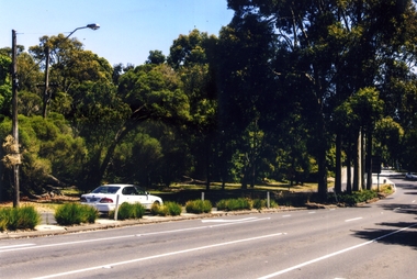
Photograph, Canterbury Road, Blackburn South, 2012
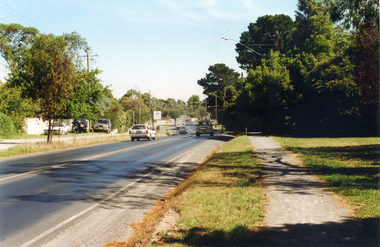
Coloured photograph of cars in Canterbury Road nearing the Blackburn Road intersection - 2012. The cars will be turning right into Blackburn Road heading south toward East Burwood. The road to the right will lead into Blackburn Road and head north towards Blackburn. Over the hill is the Blackburn South Shopping Centreroads, canterbury road, blackburn south -
 Ringwood and District Historical Society
Photograph, Club Hotel, Ringwood from Whitehorse Road. Mt. Dandenong Road to old East Ringwood looking south. Taken about 1900-10
Catalogue card reads, "Club Hotel, Ringwood from Whitehorse Road. Mt. Dandenong Road to old East Ringwood looking south. Taken about 1900-10". Label below photograph is dated 1904. -
 Whitehorse Historical Society Inc.
Photograph, Prior to Widening of Mitcham Road, 1/02/2000 12:00:00 AM
Coloured photograph of Mitcham Road looking towards Doncaster. Hedge End Road on left, Wrendale Drive on right. Prior to construction of widening of Mitcham Road.mitcham road, donvale, hedge end road, mitcham, wrendale drive -
 Whitehorse Historical Society Inc.
Photograph, Mitcham Road Before Widening, 1/02/2000 12:00:00 AM
Coloured photograph of Mitcham Road looking towards Doncaster. Donvale Nursery on right at end of road. Taken before construction began to widen Mitcham Road.mitcham road, donvale -
 Ringwood and District Historical Society
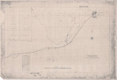
Map, Road Plan 108 - Gipps-land Road, Parishes of Bulleen and Warrandyte (Ringwood, Victoria) - 1855
Surveyor's map of the part of the main road from Melbourne to Gippsland following "Barker's Track" south of Mullum Mullum or Deep Creek. Map references include Roman numerals marking distances measured in Links between trees at turns in the road.Submitted to the Surveyor General (Signed) July 2nd 1855. -
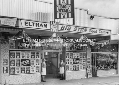 Eltham District Historical Society Inc
Photograph, Eltham Big Star Food Centre, Main Road, Eltham, c.1966
In February 1965, Staffs Railway Store, the oldest business premises in the Eltham shopping district was demolished. Formerly a self-service grocery, restaurant and electrical repair shop, the building for many years housed Eltham’s only ‘family’ grocer and feed store. Earlier it had appeared to have been the town’s bakery. The building had been purchased in late March 1939 by Mr Eric N. Staff. At the time of E.N. Staff’s purchase there were huge bakers’ ovens located at the rear and the building also had a well and four toilets for employees. When the ‘pictures’ came to Eltham with the opening of the Eltham Public Hall across the road in 1941, Mr E.N. Staff extended the business and opened a milk bar and sweet shop. Further extensions re-established the tea rooms of days gone by. Mr E.N. Staff conducted business for about 15 years before handing over the reins to his son, Ray Staff. When his son Ray took over, the milk bar and tea rooms were closed for several years but the milk bar and was later re-opened and subsequently became a greengrocers and later again, a restaurant. The tea rooms section was converted to an electrical repair shop about 1955. Electoral Roll records for 1967 record Raymond Charles Staff at 929 Main Road, Eltham, grocer, and in 1968 at Lot 4, Hillcrest Avenue, Eltham, taxi truck operator. So it would appear that Ray continued to run the business for approximately two years after the original store was demolished and a new supermarket was built. Today, 929 Main Road is the Nongkhai Thai Restaurant and is precisely where the original Staffs store stood. Even though the facade has been modified at eye level with new larger windows, the upper facade is identical to that of the new Eltham Big Star Food Centre of 1965/66. But how did the original building, the oldest premises in the 1965 era shopping centre come about? On August 12th, 1902 at the Eltham Courthouse, appearing before T. Smallman, Esq,. Police Magistrate, and Messrs. W. Duncan and W.J. Taylor, Justices of the Peace is Luther Haley, baker. Wilfred Henry Johnston, by his agent Stanley Ernest Elder had applied for a warrant of ejectment under the Landlord and Tenant Act 1890 against Luther Haley from the bakery premises at the corner of Main Road and York Street. From the evidence presented we learn that Mrs Burgoyne of Eltham had purchased the property some months earlier from Mr Johnston, which consisted of a store and bakery establishment at Eltham occupied by Mr. Luther Haley, and whose lease expired some little time back, and up to the present time, Mr. Haley was not prepared to leave. He informed the court that he is unable to secure at Eltham a suitable house in which to carry on his business, but was building a place near the railway station which he expected to be done in about three weeks time, and he is then prepared to give up possession of the premises he now occupies. Mr Smallman informed the defendant, Luther Haley, that he will have to quit the premises in three weeks from the present date, and that a warrant of ejectment would be issued. However he also informed Mr Haley that he would order the warrant to lie in the office for three weeks from that date. The premises under construction referred to by Luther Haley in court were situated on the western side of Main Road, near the railway station slightly opposite present-day Arthur Street. It was opened around September 1902 as a General Store, Bakery and Tea Rooms. This was the original building in the present-day shopping precinct. At the time the only thing nearby was the railway station. Luther Haley’s business appeared to prosper and he would have catered to not only the locals abut also day visitors by train on Sundays coming up from Melbourne, offering fresh baked produce, tea rooms and summer drinks. The fields across Main Road running between present day Arthur Street and Luck Street were known as Haley’s Paddock and at times were used for community festivities and picnics. A newspaper report on the annual State schools picnic held at Haley’s Paddock on March 11, 1904 described it as “quite close to the railway station, and is quite capable of holding comfortably 10,000 people. With its ample shade and hilly surroundings, it is an ideal place for any gathering.” Luther Haley successfully ran his general store, bakery and tea rooms until 1917 when he and his family departed the district and moved to Westgarth Street in Northcote where he changed careers and became a publisher. It was then taken over by Hannah Lloyd and became known as Lloyd’s Railway General Store from 1917 to 1920. From then it had a succession of owners, one as short as two months until March 31, 1939 when the Grocery Business formerly carried on by Mr. T.K. White of Eltham for the previous eight years was purchased by Mr Eric N. Staff of Research and became known as E.N. Staff’s Railway Store. The ownership timeline for the store is as follows: Luther Haley Sep 1902-1917 Hannah Lloyd 1917-c.Feb 1920 Messrs J.R. & N.E. Lee 1920-Sep 1922 A. & E. Copeland Sep 1922-Sep 1925 Mr Price Sep 1925-Nov 1925 Mr Warren Nov 1925?-Nov 1926 A.W.J. Edwards Nov 1926-1931 T.K. White 1931-Mar 1939 Eric Staff Apr 1939-c.1954 Ray Staff c.1954-Feb 1965 then demolished Ray Staff Eltham Big Star Food Centre c.1965-1967 Research and copy: Peter Pidgeon (EDHS) Digital file only from scan of copy on loan to EDHSa. copeland, a.w.j. edwards, big star food centre, e. copeland, eltham, eric staff, general store, hannah lloyd, j.r. lee, lloyd's general store, luther haley, main road, n.e. lee, price, ray staff, staffs general store, supermarket, t.k. white -
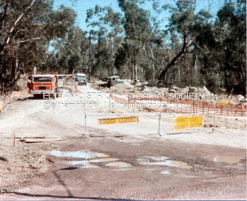 Eltham District Historical Society Inc
Photograph, Widening of Main Road Bridge over Diamond Creek, Eltham, c.1984, 1984c
Four colour photographs showing road works for widening of the Main Road bridge over Diamond Creek; two showing Main Road south of Mt Pleasant Road and one from the corner of Antoinette Blvd, Eltham, Vic.eltham, main road, diamond creek, main road bridge, bridges, construction -
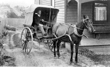 Surrey Hills Historical Society Collection
Photograph, Horse and buggy at 44 Guildford Road Surrey Hills, 1913
Jocelyn Hall indicated in notes that the gentleman could possibly be an estate agent. This was confirmed by a grandson of the original owners. (REF: Email 1/8/2020) The original photos is thought to have been a publicity photo for the real estate agency. Carl Theodore Offszanka (1874-1944) was born in Germany. He is listed in electoral rolls at 44 Guildford Road from 1915, occupation furrier, with his wife Ida (nee Schade, 1882-1963), also born in Germany. They were married in Victoria in 1908. In later electoral rolls at the same address are Erna Helena (b 1913; d 1996) and Maria Eliese (b 1910; m Benedict Francis Rieusset in 1936). Both daughters are listed as typists. Also listed is Bernard George (b 1914; d 1987) who in later electoral rolls is described as a process worker. He served in the AIF in the Second World War. Not listed is Carl Bernard b 1909. The Offszanka family lived at 44 Guildford Road from 1913 until post-1980; they came to Surrey Hills from Richmond. Their home was called 'Westfalia' (ref: 1919 electoral roll), presumably after the region in NW Germany. It is not known when Carl and Ida migrated from Germany. This home has had a 2nd storey added to it in late 1990s. According to a family descendant (REF: Email 1/8/20 from grandson) Carl Theodor Offszanka purchased the home in 1913 for £616. He also purchased the adjoining vacant block of land at 42 Guildford Road and ran a large orchard on it before later selling it. This appears to have been between 1920-1930. The family continued to occupy the house until after 1980 when Erna Helena and Bernard George are listed in the electoral rolls. Our property register lists Erna Helena Offszanka as the last member there. She died on 5 May 1996. The Offszanka family occupied this home from its beginning for over 70 years. Such long-term occupancy by one family is unusual.Black and white photo of a ? dark-stained timber Edwardian home at 44 Guildford Road, Surrey Hills. A hooded buggy is located in the rough driveway at the side of the house. A gentleman in a hat and with a moustache is seated in the buggy. A tall building can be seen in the far distance and a street leading up the hill from Canterbury Road.edwardian style, houses, guildford road, horse drawn vehicle, carl theordore offszanka, miss ida schade, mrs ida offszanka, miss edna helena offszanka, miss marie elsie offszanka, mr bernard george offszanka, estate agent, mr carl bernard offszanka, westfalia -
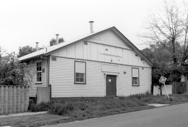 Surrey Hills Historical Society Collection
Photograph, Scout Hall at 7 Robinson Road, Surrey Hills in 1990
The Box Hill Reporter noted on 22 January 1926 that at the monthly meeting of the Surrey Hills Progress Association the Secretary reported that “the ground had been purchased for the Boy Scout Hall, that plans had been prepared, and accepted by the building committee. As soon as the timber was available the work would be proceeded with. The Boy Scout Hall movement has been taken up by the association to try to secure a permanent meeting place for the boys of the district. Up till now they have no fixed place, nor have they had a qualified scout master. Mr. Bert Chenu, one of the committee, has been appointed to that position, and is carrying out his duties energetically. Having raised enough money to purchase the land (situated in Robinson's road, Surrey-Hills near the Drill Hall) the association's committee is now about to erect the building by means of properly organised working bees.” The Association organised markets, card evenings and dances to raise necessary funds. The volunteer labour included the parents of boys who had become scouts, led by builder Robert Hayes of 186 Union Road and his son, who was also a builder. Early ownership is unclear as it is believed that it was not purchased by the scouting movement until 1955. The hall was used by other groups as well as the scouts. Benmont Kindergarten operated on the site from c1930. This is confirmed by oral testimony, Sands & McDougall entries and the Alan Hold property register (part of the SHNC Heritage Collection.) It was also used as a ballet school and for local dances. The hall was situated on a small block of land, just 410 sq m, and in late 2019 it was put up for sale by Scouts Victoria. Most recently home to 1st Boroondara Scout Group and previously 11th Camberwell Scouts, it was sold for something near $1.3M. During May 2020 the modest hall was demolished. Items of significance were removed before the sale by Scout Heritage. A black and white photograph of a building with a small sign identifying it as 11th Camberwell Central Scout Group.robinson road, surrey hills, scout halls, scouts, buildings, structures and establishments, (mr) robert hayes, union road, builders, surrey hills progress association, benmont kindergarten, dances, ballet schools -
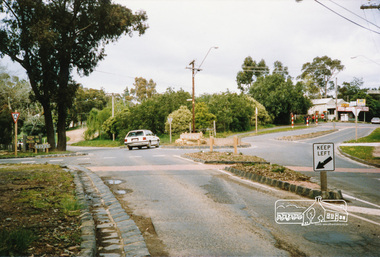
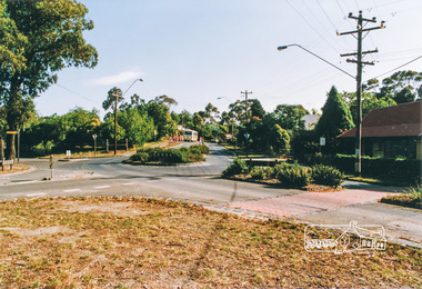 Eltham District Historical Society Inc
Photograph, Main Road, Panton Hill
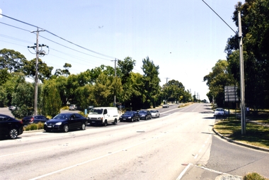
Six colour photographs of Main Road Panton Hill showing Bishops Road roundaboutmain road, st andrews road, kangaroo ground/st andrews road, bishops road, roundabouts, panton hill -
 Eltham District Historical Society Inc
Photograph, Main Road, Panton Hill
Two colour photographs of Main Road Panton Hill showing Bishops Road roundaboutmain road, st andrews road, kangaroo ground/st andrews road, bishops road, roundabouts, panton hill -
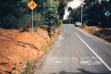
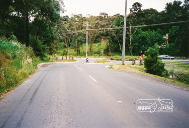 Eltham District Historical Society Inc
Photograph, Research-Warrandyte Road, Research
Three colour photographs of Research-Warrandyte Road, Research including roundabout at Main Roadresearch, research warrandyte road, warrandyte road, main road, roundabouts -
 Eltham District Historical Society Inc
Photograph, R. Dinsdale, Metery Road, Eltham; 4 Dec 1986, 4/12/86
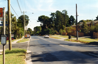
Colour photograph of Metery Road, Eltham approx. 60m south of Mt Pleasant Roadmetery road, eltham -
 Whitehorse Historical Society Inc.
Map, Whitehorse Road, Mitcham, 1972
Enlarged aerial photograph of area around intersection of Whitehorse Road and Heatherdale Roads, Mitcham.Enlarged aerial photograph of area around intersection of Whitehorse Road and Heatherdale Roads, Mitcham.Enlarged aerial photograph of area around intersection of Whitehorse Road and Heatherdale Roads, Mitcham.whitehorse road, mitcham, heatherdale road, mitcham, ringwood, maroondah highway, aerial photographs -
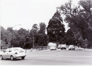
Whitehorse Historical Society Inc.
Map, Springvale Road, 1968
Aerial photograph of cnr Springvale Road and Burwood Highway, south past Highbury Road.Aerial photograph of cnr Springvale Road and Burwood Highway, south past Highbury Road.Aerial photograph of cnr Springvale Road and Burwood Highway, south past Highbury Road.aerial photographs, highbury road, burwood east, burwood highway, burwood east, springvale road, burwood east -
Whitehorse Historical Society Inc.
Document, Eastern Arterial Road, 1986
Eastern Corridor Road Development (ECORD) Doncaster to Ringwood. Road Construction Authority 1986eastern freeway, ringwood bypass, roads and streets -
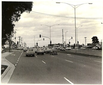 Whitehorse Historical Society Inc.
Photograph, Springvale Road looking South, 1/09/1983 12:00:00 AM
Donor developed Educational Programme at Blackburn Lake.Black and white photo of Springvale Road looking South. Intersects with Whitehorse Road, Nunawading.meagher, dorothy, springvale road, nunawading, whitehorse road, nunawading -
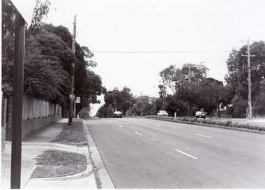
 Whitehorse Historical Society Inc.
Photograph, Blackburn, Blackburn Road, 6/01/2001 12:00:00 AM
Black and white photograph of Blackburn Road, Blackburn looking north from Canterbury Road.blackburn road, blackburn, canterbury road, blackburn. -
 Whitehorse Historical Society Inc.
Photograph, Canterbury Road, Blackburn, 6/01/2001 12:00:00 AM
Black and white photograph of Canterbury Road Blackburn looking east from Blackburn Road.canterbury road, blackburn., blackburn road -
 Whitehorse Historical Society Inc.
Photograph, Blackburn Road, Blackburn, 6/01/2001 12:00:00 AM
Black and white photograph of Blackburn Road Blackburn looking north from Canterbury Road.blackburn road, blackburn., canterbury road -
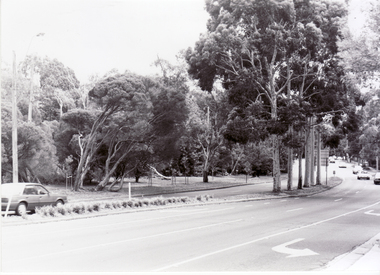
 Whitehorse Historical Society Inc.
Photograph, Blackburn Road, South Blackburn, 2012
See NP4006Coloured photograph of Blackburn Road heading north from Canterbury Road toward Blackburnblackburn road, blackburn south, canterbury road blackburn south -
 City of Moorabbin Historical Society (Operating the Box Cottage Museum)
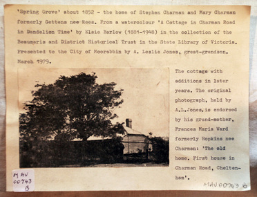
Document - Photograph, photocopy, of ‘Spring Grove’ 19th C house, Charman Road, Cheltenham, c1979
In 1852 Stephen Charman purchased 160 acres bounded by Charman Rd and Balcombe Road in an area called Spring Grove , later Cheltenham. A spring ran through the land providing a good source of water. Stephen aged 21 years had arrived in Melbourne 1842 as one of Henry Dendy’s emigrants . His Ship passage was paid by the Colonial Land and Emigration Commission and in return he was required to work on the land of the Henry Dendy Special Survey Brighton 1841. However Henry Dendy could not provide enough work for all the emigrants that arrived and Stephen had to obtain other work. Then sadly his young wife Harriett and their infant died. 1850 Stephen married widow Mary Gettens, a Publican in Little Collins Street, with 5 children. Stephen & Mary built a wattle and daub hut and established a market garden producing marigolds for Martin & Pleasance Pharmacists, Melbourne. They had 7 more children and built a weatherboard cottage that was used for early Methodist Church services. Stephen donated 1 acre to the Methodist Church in 1855 for Chapel , School and Cemetery. This is the weatherboard cottage in the photocopy showing the building extension, The road between Cheltenham and Mentone bears their name. Mary died in 1870 and Stephen remarried 1878 and died in Gippsland 1906. The original Photograph is endorsed by Francis Marie Ward , formerly Hopkins nee Charman who was the grandmother of Mr A.L Jones A photocopy of a black and white photograph of ‘Spring Grove’ , that was the first house in Charman Road , Cheltenham c1852 , showing later extensions. spring grove cottage 1852, schumer l, cheltenham, charman stephen, early settlers, jones a l, gettens mary, rees mary, charman mary, moorabbin, brighton, henry dendy special survey 1841, ward frances marie, charman frances marie -
 Bacchus Marsh & District Historical Society
Map, Tracing of plan shewing portion through Bacchus Marsh District of proposed new Main Road between Gisborne and Blackwood
Road construction and planning was a primary function of the early local government authorities in rural and regional Victoria. This plan is indicative of the sort of documentation which generated considerable public interest and comment in rural communities. The date of this plan is not clear. Newspaper articles in the Bacchus Marsh Express around 1869 contain numerous references to the proposed new road between Gisborne and Blackwood which suggests this plan may date from the late 1860s or early 1870s.A single page paper map showing the proposed route of a main road to be constructed between Gisborne and Blackwood. The map is pasted into a bound volume containing 76 maps or plans in total. High resolution digital image stored on BMDHS computer network. roads, road plans, bacchus marsh victoria maps, gisborne to blackwood main road -
 Surrey Hills Historical Society Collection
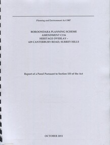
Book, Boroondara Planning Scheme Amendment C116 Heritage Overlay - 629 Canterbury Road, Surrey Hills, Oct-11
Report of a panel pursuant to Section 153 of the Planning and Environment Act regarding the property at 629 Canterbury Road, Surrey Hills - an Edwardian two story red-brick butchers' shop built in 1897 for the Tacey family.Report of a panel pursuant to Section 153 of the Planning and Environment Act regarding the property at 629 Canterbury Road, Surrey Hills - an Edwardian two story red-brick butchers' shop built in 1897 for the Tacey family.abermore pty ltd, heritage studies, tacey family butchers, surrey hills, canterbury road, (ms) natica schmeder, sherry james, jo james, (mr) mark marsden, (mr) bryce raworth, 2011, 1897 -
 Eltham District Historical Society Inc
Photograph, View of Main Road from Eltham Shire Office, 895 Main Road, Eltham, 1967, 1967
35mm Colour positive transparency Mount - Agfacolor Service (Blue stepped)eltham shire office, main road -
 Eltham District Historical Society Inc
Photograph, View of Main Road from Eltham Shire Office, 895 Main Road, Eltham, 1967, 1967
35mm Colour positive transparency Mount - Agfacolor Service (Blue stepped)eltham shire office, main road