Showing 846 items
matching bendigo creek.
-
 Bendigo Historical Society Inc.
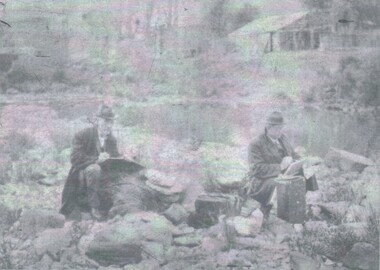
Photograph - PORTRAIT - SHIRLOW AND HUDSPETH
Negative Photograph of John SHIRLOW and John HUDSPETH, both drawing, sitting on the bank of a creek/water way, behind the men high up on the bank, a brick building and looks like a timber shed. On computer check SHIRLOW was a artist.Bartlett Bros. Bendigo.photograph, portrait, john shirlow. john hudspeth. -
 Bendigo Historical Society Inc.
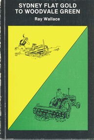
Book - SYDNEY FLAT GOLD TO WOODVALE GREEN, 1984
Sydney Flat Gold to Woodvale Green. Espress Printers, Bendigo. ISBN L0-9591143-0-0. Cover Design & illustrations by Kevin Vallence. Woodvale Progress Association 1984. Photographs and Illustrations and plan. 80 pages. With IndexRay Wallacehistory, woodvale, ray wallace, woodvale progress association, sydney flat, weddikar run, myers creek, eaglehawk, poet, book collector, naturalist, history 1845, gold 1852, squatters, government, early settlers, farmed, school, church, industry, pubs, railway, sport, artists -
 City of Greater Bendigo - Civic Collection
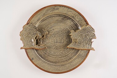
Decorative object - Ceramic platter, Bendigo Pottery, Strathfieldsaye Shire 1866 - 1991, 1991
... Graham Masters is a potter based at Sweenies Creek, just...Graham Masters is a potter based at Sweenies Creek, just ...Graham Masters is a potter based at Sweenies Creek, just outside Bendigo, Victoria who specialises in a patented technique of low relief stoneware depicting Australian animals and landscapes. He obtained a Diploma of Art and Design in Ceramics from the Bendigo Institute of Technology in 1973, then operated a pottery for a year in Bendigo, before becoming an employee, then a partner at Maldon Pottery, Victoria with Neville Wilson and Thomas Metcalf. He left Maldon to set up his own pottery at Sweenies Creek in 1984. (1.) (Judith Pearce). Built in 1869, the (former) Strathfieldsaye Shire Hall is one of The City of Bendigo's earliest surviving public buildings. Designed by George Steane and built by George Pallett in 1869 the Strathfieldsaye Shire Hall has aesthetic significance as a purpose built Shire Hall designed in the Free Classical manner. It is also of importance as an early example of the novel system of cavity wall construction. The building is largely intact and unaltered. Other important elements include the arched portico of the main entrance with brick arched features on either side; the brick quoining and dressings to the round arch windows; the three gabled roof; and the matching chimneys that reinforce the symmetrical design. The Hall has social significance as a temporary schooling facility in the 1870s and as a flood refuge in 1889. The Strathfieldsaye Shire Hall is a brick building designed in the Free Classical manner. This style was favoured by the Public Works Department for a number of public buildings including Shire Halls and courthouses. The form includes a central taller volume flanked by matching smaller gables. In the case of the Shire Hall these would be occupied by the Shire Secretary and Shire Engineer whilst the larger volume was the council chamber. The portico at the front is designed with a flat arch in the centre and matching smaller arches each side. The face red brick is unadorned apart from a plain string course at the roof springing point, brick quoining and dressings to the round arch windows. There are matching chimneys that are located to reinforce the symmetrical design and the original roof is believed to have been slate but is now corrugated iron. Large wheel thrown ceramic platter with a shallow well, broad flaring ledge and raised on a high foot rim. Rim decorated with slab rolled gum trees protruding on centre left and right sides of plater. which reflect the low relief image of trees and the Strathfieldsaye Shire Hall on the surface of the plate. Glazed with golden brown and cream. Front centre top; 'Shire of Strathfieldsaye'. Front lower centre '1866 - 1991 - 125 Years'. Signed 'G Master / 1991' on rim centre right. Reverse; signed 'G Master' / 1991. Bendigo Pottery stamp.shire of strathfieldsaye, bendigo pottery -
 Bendigo Historical Society Inc.
Document - Hustlers, Sheepshead and Deborah lines of reef
Albert Richardson was a mining historian who wrote widely on the mines of the Bendigo Goldfield. The park opposite the Goldmines Hotel in Marong Road, is named in his honour. Five page document, hand written by Albert Richardson on lined foolscap and edited with cross-outs and insertions, . The mines along the Hustlers line of reef and the Sheepshead line of reef are described. Mines listed on Hustlers line of reef: Fortuna Hustlers (1888 - 1913), shaft 2,240 feet at rear of Buckell and Jeffrey's offices; Royal Hustlers Reserve No. 2 - two shafts 'City" 860 feet, now covered by R.S.L. building Pall Mall, steel poppet legs 60 ft high and 'Park Shaft" at rear of Camp Hill School, 1,775 feet, steel poppet legs 60 feet high; Hustlers Hill Group first worked by Jonathan Harris in 1853 and bounded by Valentine, Anderson and Ironbark Creek to the north and Milroy Street to the east, one of first areas worked for quartz reefing. It with Garden Gully line west and Victoria Hill Ironbark, formed by far the richest cross section of the Bendigo Goldfield. Great Extended Hustlers (1865-1921) close to intersection of Anderson Street and Hustlers Road, mullock heap against road and shored up around shaft, steel poppet legs now at Wattle Gully mine, Chewton, large winding machine, air compressor south of shaft and 36 head crushing battery. Hustlers Reef (Old Hustlers) and Hustlers Reef No. 1, two shafts, main 2,210 feet, about 220 yards east of Moran Street and against Fenton Street. , No. 1 shaft 1,140 feet and about 155 yards east of Moran Street. Lansell's Comet, Lightining Hill line, 2.100 feet, on Comet Hill approx 70 yards west of Holmes Road, near Comet Creek, steel poppet legs. United Hustlers and Redan (1876-1918), main Redan, 1,830 feet about 155 yards west of Sandhurst Roead, in line with Comet Hill State School, this hill known as Redan Hill. North, or New Hustlers, once known as Agnew Hustlers, wooden poppet legs, south side, Kneebone Street, Eaglehawk. Derby line, Johnson's No. 3, South Johnson's (east shaft of Collman and Tacchi) 439 feet on west wide of Woods Street, south of Wetherall Street. Paddy's Gully Line, south to north, some shafts - Lansell's 'Sandhurst" ('Needle") Eaglehawk Road shaft 2,425 feet, about 50 yards east of Needle Loops, a brick square sided chimney with Cleopatra Needle top. British American, 789 feet, just south of Holdsworth Road. Collman and Tacchi, main shaft 2,588 feet, 60 yards west of Eaglehawk Road, California Gully. Deborah Line of Reef, The Deborah (1932-1954) shaft 2.017 feet, west of Adams Road and south of Abel Street, Quarry Hill. North Deborah (1937 - 1954) shaft 1,151 feet, Breen Street, Quarry Hill, steel poppet legs. Central Deborah (1939-1954) shaft 1,347 feet Sheepshead line of reef, Lansell's South Red, White and Blue, shaft 2,124 feet, north east of Bellevue Road and 220 yards east of Adams Road. The New Red, White and Blue Consolidated (Big Blue) main shaft 2,416 feet. Lansell's Bendigo Battery 105 head, north of 'Big Blue" on his freehold lease, commenced crushing on 24th February 1895. After closing was erected as the Showground's Industrial Hall, July 1926. North Red, White and Blue, burnt down February 1926, new company 1934, closed 1938. Document is part of the Albert Richardson Collection of Bendigo mining history. bendigo, gold mining, deborah line of reef, sheepshead line of reef, hustlers line of reef, royal hustlers reserve mine, hustlers hill group of mines, great extended hustlers, hustlers reef no. 1, lightning hill line, old comet, collman and tacchi, lansell's comet, north deborah, central deborah, dhrrpdhrsf linr og trrg, new red, white and blue consolidated mine, big blue, lansell's bendigo battery, north red, white and blue mine, albert richardson collection -
 Bendigo Historical Society Inc.
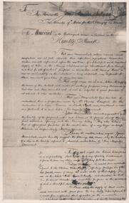
Photograph - PETITION FOR BACK CREEK RESERVOIR
Petition sent in 1886 by the residents of Sandhurst to the Honourable James Sullivan Minister of mines in the colony of Victoria requesting the construction of a reservoir on back creek. The petition is on thirty-three photographs and is inside a quite well worn plain brown folder. On the front of the folder a stamp of the Royal Historical Society of Victoria Bendigo branch with the date:1960 and the number 217. Inside the cover in blue pen: donated by the Victoria Legislative through Mr. Galvin MLA and another RHSV stamp. The Mayor of Sandhurst at the time was John McIntyre.government, state, 1886 petition -
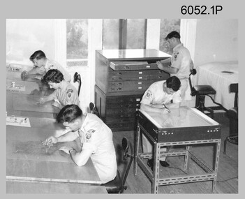 Bendigo Military Museum
Photograph - Scribing at the Army Survey Regiment, c1950s to 1979
These 10 photographs were taken over two decades from the late 1950s to 1979 at the Army Survey Regiment, Fortuna, Bendigo. The two photos taken in 1961 are annotated with named personnel and the date. The other photos are not annotated with dates, locations and names of personnel, although the technicians in the last three photos taken in 1979 are positively identified. The photos were most likely taken in the Ballroom, Ante Room and Attic, Cartographic Squadron’s main production rooms on the top floor of Fortuna Villa. Scribing was the cartographic process of drafting topographic features such as drainage, relief, vegetation, roads and culture on specially coated map reproduction material. The cartographic technician scribed out the map feature such as a creek to a specified line width on the map sheet, using a tool affixed with a metal or sapphire tipped cutter.This is a set of 10 photographs of technicians scribing topographic features at the Army Survey Regiment, Bendigo. The photographs were printed on photographic paper and are part of the Army Survey Regiment’s Collection. The photographs were scanned at 300 dpi. .1) - Photo, black & white, c1950s. unidentified personnel in Cartographic Squadron .2) - Photo, black & white, c1960s. unidentified personnel in Cartographic Squadron .3) - Photo, black & white, c1960s. unidentified personnel in Cartographic Squadron Attic .4) - Photo, black & white, c1960s. Cartographic Squadron Attic .5) - Photo, black & white, Oct 1961. L to R: PTE P. Carseldine, PTE H.S. Pasley, PTE C.A. Brown, WO2 M.A. McLaren, CPL Jennifer H. Murray. Cartographic Squadron .6) - Photo, black & white, Oct 1961. CPL Jennifer H. Murray. Cartographic Squadron .7) - Photo, black & white, 1979. SPR Mick Ellis in Cartographic Squadron .8) - Photo, black & white, 1979. SPR Mark Casey in Cartographic Squadron .9) - Photo, black & white, 1979. SPR Sharon (Jones) Treble in Cartographic Squadron .10) - Photo, black & white, 1961. PTE BJ Madex. Cartographic Squadron.1 to .4 - annotated “Scribing” .5 – annotated “Scribing PTE P. Carseldine, PTE H.S. Pasley, PTE C.A. Brown, WO2 M.A. McLaren, CPL Jennifer H. Murray. Oct 1961” .6 - annotated “Scribing CPL Jennifer H. Murray. Oct 1961” .7 to .9 - annotated “Scribing” .10 – annotated “PTE Madex Oct 61”royal australian survey corps, rasvy, army survey regiment, army svy regt, fortuna, asr, carto