Showing 110511 items matching " roads"
-
 Hume City Civic Collection
Photograph, early 1990s
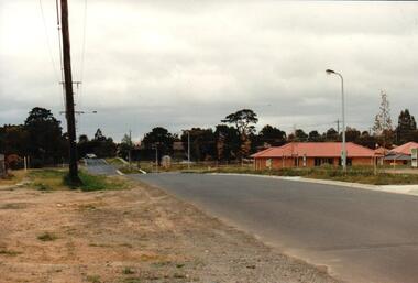
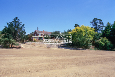
The series of 5 photographs feature different views of the Woodlands Housing Development which opened up land bounded by Gap and Anderson Roads, Cornish Street and Elizabeth Drive in the early 1990s. It was a large housing development built close to Sunbury township.A coloured photograph of one of the last housing developments which took place in the old township area. It is a photograph taken at the north end of Anderson Road looking towards Gap Road. One house has been built and there are a number of 'For Sale' signs of blocks fronting Anderson Road. Guttering and driveways have been formed on one side of the road.housing developments, anderson road, george evans collection -
 Eltham District Historical Society Inc
Slide, Sackville Street, Montmorency; split road near no. 36, c.Oct. 1980
... Roads ...One of a series of images of roads and infrastructure focussed on the Quinn Estate in Montmorency taken by Eltham Shire Council Planning and Engineering officers. They provide perspective of the changes in housing styles and road development that began sweeping in from the mid 1970s with increasing urbanisation of what was once more outlying suburbs and regions.35 mm colour positive transparency Mount - Kodak Kodachrome CardProcessed Oct 1980sackville street, infrastructure, montmorency, roads -
 Glen Eira Historical Society
Album - Album page, Neerim Road, Circa 1972
This photograph is part of the Caulfield Historical Album 1972. This album was created in approximately 1972 as part of a project by the Caulfield Historical Society to assist in identifying buildings worthy of preservation. The album is related to a Survey the Caulfield Historical Society developed in collaboration with the National Trust of Australia (Victoria) and Caulfield City Council to identify historic buildings within the City of Caulfield that warranted the protection of a National Trust Classification. Principal photographer thought to be Trevor Hart, member of Caulfield Historical Society. Most photographs were taken between 1966-1972 with a small number of photographs being older and from unknown sources. All photographs are black and white except where stated, with 386 photographs over 198 pages. "Edenkillie" was the home of Frederick Jowett, Caulfield's shire secretary and town clerk from 1887 to 1921. The Outer Circle Railway's Oakleigh section opened 1890 and closed 1895. Victorian Heritage database (as of 26/10/2021) HO45 Edenkillie https://vhd.heritagecouncil.vic.gov.au/places/35545 "Edenkillie" at 37 Neerim Road, Glenhuntly, is a substantial two storeyed polychrome brick villa, built for Frederick Jowett, municipal secretary, in 1890. It has aesthetic, historical and social significance. "Edenkillie's" aesthetic value derives from its survival as a substantially intact example of a common villa form expressed in polychrome brickwork. Its historical significance lies in its association with Frederick Jowett, Shire of Caulfield secretary and town clerk for over three decades. Its social significance is derived from the building's ability to demonstrate the kind of lifestyle which a local government administrator could enjoy during the Land Boom.Page 145 of Photograph Album with four landscape photographs from Neerim Road: two photographs of No 37 and two of the Outer Circle Railway Reserve.Handwritten: Neerim Road [top left] / 37 NEERIM ROAD 1OCT 1972 [under top left photo] / 37 NEERIM RD 1 OCT 1972 [under top right photo] / OUTER CIRCLE RAILWAY RESERVE MURRUMBEENA [under bottom left photo] / 145 [bottom left]trevor hart, neerim road, murrumbeena, caulfield, edenkillie, glen huntly, polychrome brick, mansions, frederick jowett, town clerks, shire of caulfield, outer circle railway, railways, parks and reserves, outer circle railway reserve, cast iron work, verandahs, balconies -
 Hume City Civic Collection
Photograph
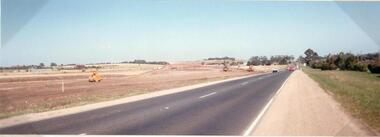
This photograph is of the duplication of the Calder Highway at Diggers Rest in the vicinity of Plumpton Road.A coloured panoramic view of the construction of the duplication of the Calder Highway in the vicinity of Plumpton Road. It is unmounted.calder highway, diggers rest, highway duplication, road construction and maintenance, plumpton road, george evans collection -
 Whitehorse Historical Society Inc.
Document, Certificate of Title - George Albert Smith, 1928, 1934
Certificate of TitleCertificate of Title for Lot 13 Railway Road, Mitcham and correspondence re outstanding rates.Certificate of Title shire of blackburn and mitcham, land titles, rates, smith, george albert, east road, mitcham, creek road, mitcham, railway road, mitcham, lot 13 -
Glenelg Shire Council Cultural Collection
Photograph - Photograph - Bridge Construction, 29/05/1957
Port of Portland Authority ArchivesFront: Back- 'Bridgewater road Bridge (otway street) 29/5/57' - pencilport of portland -
 Vision Australia
Plan - Image, Royal Vic Institute for the Blind Hirings Service, 18/12/1943
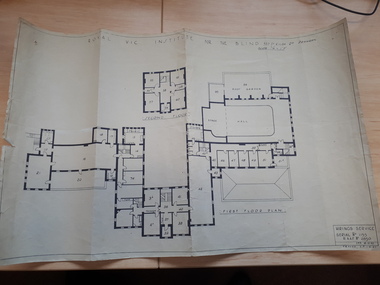
Plan of the first and second floors of the main building at 557 St Kilda Road, created by the RAAF during it's occupation of the same between 1942-1944.1 architectural plan of St Kilda Road main buildingroyal victorian institute for the blind, plans, raaf -
 Warrnambool and District Historical Society Inc.
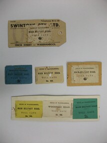
Document - Tickets, Toll road, 1866-1869
In 1866, in an effort to maintain the main roads of the region it was decided to establish toll roads on the Belfast, Woodford Purnim and Allansford roads. Gates were erected and the leases were disposed of by auction. In 1867 the Woodford tollhouse was destroyed by fire suspected to be deliberate. The tolls were removed three years later after much opposition. These tickets are a physical link to one of the earliest attempts to introduce a toll road in the district. Seven toll road tickets five mounted on card. Light paper. Six are for the Main Belfast Road and one for the Woodford road. There are various prices ranging from sixpence to three shillings. Four are cream in colour, one each of blue, yellow and green. They are accompanied by a small newspaper cutting which relates the discovery of one such ticket and the situation of the Belfast tollhouses which were later relocated to 94 and 96 Henna Street near the Alderdice brass foundry.Shire of Warrnambool, Fairfax & Laurie Printers. tollgate, tollgate tickets, woodford toll tickets, shire of warrnambool -
 Tarnagulla History Archive
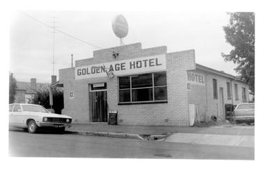
Photograph of the Golden Age Hotel, Tarnagulla, Late 1960s
Murray Comrie Collection. Building is still operating as the Golden Age Hotel on Commercial Road, Tarnagulla.Monochrome photograph depicting the Golden Age Hotel, located in Commercial Road, Tarnagulla.tarnagulla, commercial road, golden age hotel, buildings -
 Melbourne Tram Museum
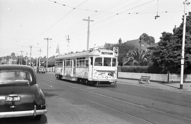
Negative - Tram 915 Centenary Car - Riversdale Road, Wal Jack, 11/02/1951
Photo by Wal Jack, of SW6 915, in Riversdale Road, Camberwell decorated for the 50th anniversary of Federal Government, 1951. Tram in bound to the City, Route 74 passing a stop 29 at Hasings Road. Note the shade in the overhead by the street light. Print dated 11-2-1951, though Wal Jack's album dates it as 9-2-1951. See also Reg Item 5179.Demonstrates a decorated tram.Black and white negative and copy print with photographers details on the rear."MMTB SW6 915 as Centenary Car from Burwood in Riversdale Road, Camberwell at Hastings Road stop no. 29, 11-Feb-1951 and Wal Jack Stamp with neg No. T693 written in,trams, tramways, sw6 class, riversdale road, tram stops, route 74, tram 915 -
 Eltham District Historical Society Inc
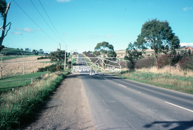
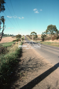
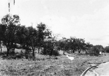
Slide - Photograph, Eltham-Yarra Glen Road, Kangaroo Ground, c.May 1988
... roads ...Looking east along Eltham-Yarra Glen Road, Kangaroo Ground, c.May 198835mm colour positive transparency (1 of 36) Mount - Kodak KodachromeProcess Date MAY 88Minfrastructure, roads, eltham-yarra glen road, kangaroo ground -
 Eltham District Historical Society Inc
Slide - Photograph, Eltham-Yarra Glen Road, Kangaroo Ground, c.May 1988
... roads ...Looking east along Eltham-Yarra Glen Road, Kangaroo Ground, c.May 198835mm colour positive transparency (1 of 36) Mount - Kodak KodachromeProcess Date MAY 88Minfrastructure, roads, eltham-yarra glen road, kangaroo ground -
 Phillip Island and District Historical Society Inc.
Photograph, Bryant West, 1930
... roads ...One of a collection of over 400 photographs in an album commenced in 1960 and presented to the Phillip Island & Westernport Historical Society by the Shire of Phillip IslandPhotograph looking down Cemetery Road,)unmade (now Coghlan Road) near Rhyll, lined with Gum Trees - early 1930's - car in centrelocal history, photography, photographs, cemetery road, rhyll, black & white photograph, roads, gum trees, cars, cemetery road to be renamed coghlan road, coghlan road phillip island, john jenner, bryant west -
 Chelsea & District Historical Society Inc
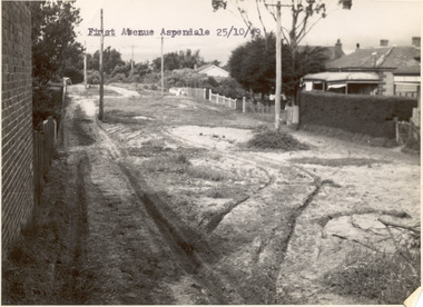
Photograph - First Avenue, Aspendale, 1949
This photo is one of a collection of photos taken during Alan Niemann's - Drainage-Road Making Scheme. First Avenue runs between Station Street and Sixth Avenue.Black and white photo looking east along First Avenue, Aspendale. The road us unmade and rusted with vegetation growing on the road, houses and electricity poles line both sides. unmade street, aspendale, first avenue, alan niemann, drainage-road making scheme -
 Eltham District Historical Society Inc
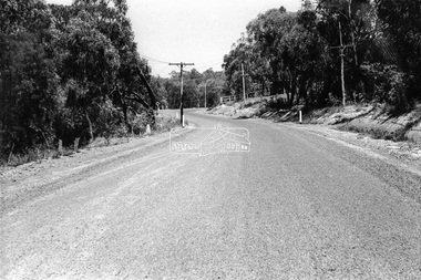
Photograph - Black and White Print, Unidentified road, Eltham district, c. Sep. 1966
... Roads ...Black and white photographic printOriginally located in a Filmpro King Size Prints processing envelope $3.01 Shire of Eltham 9/9/66 and noted as Calrossie Ave area and crossed out Eltham-Yarra Glen Road, Bridge Street to Elsa Court existing conditions mid 1967infrastructure, roads, unidentified -
 Eltham District Historical Society Inc
Photograph - Black and White Print, Unidentified road, Eltham district, possibly Montmorency, c. Sep. 1966
... Roads ...Black and white photographic printOriginally located in a Filmpro King Size Prints processing envelope $3.01 Shire of Eltham 9/9/66 and noted as Calrossie Ave area and crossed out Eltham-Yarra Glen Road, Bridge Street to Elsa Court existing conditions mid 1967infrastructure, roads, unidentified -
 Ringwood and District Historical Society
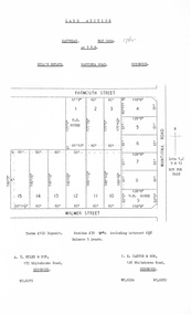
Document, Auction Flyer - Hill's Estate, Wantirna Road, Ringwood - 1960
Typewritten details of Land Auction, 14th May, 1960, with map showing ten allotments in area bounded by Yarmouth Street, Wantirna Road and Walmer Street. Terms £100 Deposit. Residue £30 qrt including interest 6-1/2% Balance 5 years. (Agents) - A.T. Miles & Son, 175 Whitehorse Road, Ringwood WU.6215. C.E. Carter & Son, 126 Whitehorse Road, Ringwood WU.6024, WU.6830. -
Whitehorse Historical Society Inc.
Document, Tunstall Town Estate, 1/03/1926 12:00:00 AM
Auction brochure of Tunstall Town Estate.Auction brochure of Tunstall Town Estate, cnr Whitehorse and Springvale Roads, Tunstall by Coghill & Haughton.Auction brochure of Tunstall Town Estate. kelly, john james, tunstall town estate, whitehorse road, tunstall, springfield road, tunstall, coghill & haughton, glendale street, nunawading, silver grove, nunawading, railway parade, nunawading -
![Construction of the electric tram line in Cotham Road [Kew]](/media/collectors/550653872162f11fb04854aa/items/662890b16214a76cee3ec4c2/item-media/662891076214a76cee3ed17d/item-fit-380x285.jpg) Kew Historical Society Inc
Kew Historical Society IncPhotograph - Construction of the electric tram line in Cotham Road [Kew], E.J. Dower, 1913
One of a small album of six photographs of the construction of the Cotham Road tramline in Kew, taken by Edgar James Dower in the second decade of the twentieth century. The reverse of each photo contains notes, written over time by the photographer, which are contained in the 'Inscriptions' field. Born and raised in Olinda, Dower's family later moved to Surrey Hills. He worked as an adult as a clerk in the city office of the Metropolitan Gas Company, and in his role as a 'collector', he was able to photograph scenes including the construction of tram and train lines and associated buildings in Kew, Hawthorn, Camberwell and Surrey Hills. Later he established a real estate agency with his brother - the E.J. Dower Real Estate Agency, Dandenong Office. The album as a whole can be viewed separately as the parent file.The image is an historically significant record of the development of transport infrastructure which was used to connect Victorians in the first two decades of the twentieth century. This development resulted from increases in population and the consequent extension of Melbourne's suburbs. The photographs in the album, as well as Dower's single photos mounted on card, individually and collectively richly detail the labour of workers and the tools and machinery used to create and extend Melbourne's tram and train networks in the years preceding and during World War 1.The fifth of six annotated photos in an album of photographs of the construction of the St Kilda to Kew electric tram line, taken in Cotham Road, Kew, by the amateur photographer, Edgar James Dower, in 1913. The album contains images detailing the preparation for the laying of the tracks plus work laying the line. The photographer notes on a number of the photos that the metal tracks were collected from the Hawthorn railway siding. The album, together with other phots by E.J. Dower has been made available by the owners for the Kew Historical Society to digitise and publish online and in print.Annotation verso: "Preparing tram line Cotham Road Kew for electric trams, looking west / 1913"keywords, theme -- connecting victorians by transport and communications, theme -- travelling by tram, photographers -- edgar james dower, cotham road -- kew (vic.) -
Whitehorse Historical Society Inc.
Article, Winlaton Youth Training Centre, 2008?
History of Winlaton Youth Training Centre for female offenders.History of Winlaton Youth Training Centre for female offenders, which was located at 186 Springvale Road NunawadingHistory of Winlaton Youth Training Centre for female offenders.springvale road nunawading, no. 186, winlaton youth training centre -
 City of Moorabbin Historical Society (Operating the Box Cottage Museum)
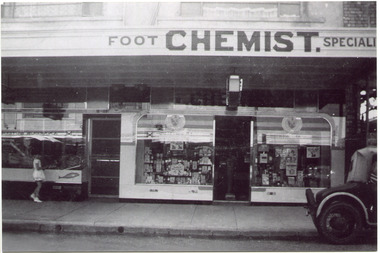
Photograph, Black & White, Mr Moore's 1st Chemist Shop Centre Road, Bentleigh c1930, c1930
Early settlers in the Parish of Moorabbin, County of Bourke, established market gardens and farms in the area of Henry Dendy's Special Survey 1841 Brighton. Small communities grew near Churches & Schools and shops and businesses were established. Following the opening of the Railway line from Caulfield to Mordialloc 1881 the shops and business moved from the Tucker Road /Centre Road ( East Brighton ) East Bentleigh area to be close to the transport. Shops, businesses and housing developed along Centre Road between Thomas Street and Jasper Road. Mr Arthur Moore established his 1st shop in 395 Centre Road c1930 and later moved along the road to a site next to Coles Variety Store.Following the opening of the Railway line from Caulfield to Mordialloc 1881 the shops and business moved from the Tucker Road /Centre Road East Bentleigh area to be close to the transport. Shops, businesses and housing developed along Centre Road between Thomas Street and Jasper Road. Mr Moore established his 1st shop in 395 Centre Road c1930 and later moved along the road to a site next to Coles Variety Store.Black & White photograph of Mr Arthur Moore's 1st Chemist Shop, 384 Centre Road Bentleigh c 1930 back Handwritten information unsignedbentleigh shopping centre c1930, east brighton, railway line caulfield -mordialloc 1881, chemists, pharmacy, moore's moorabbin shire, smith j l, smith mary ann, stanley helen, smith vic, smith harry redvers, chaff cutter, horse drawn carts, toll gates brighton, motor cars 1900, steam engines, early settlers, bentleigh, mckinnon, parish of moorabbin, city of moorabbin, county of bourke, moorabbin roads board, shire of moorabbin, henry dendy's special survey 1841, were j.b., bent thomas, o'shannassy john, king richard, charman stephen, highett william, ormond francis, maynard dennis, market gardeners, vineyards, orchards -
 Federation University Art Collection
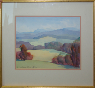
Painting - Watercolour, 'Towards Avoca' / 'Mount Buninyong in Autumn' by David Alexander, 1999
This item is part of the Federation University Art Collection. The Art Collection features over 1000 works and was listed as a 'Ballarat Treasure' in 2007.Unframed double sided landscape artwork by David Alexander. One side is 'Towards Avoca' and the other side is 'Buninyong From Main Road, 24/04/1999'David Alexander wrote on 'Buninyong From Main Road, 24/04/1999' "Wash wouldn't dry. People everywhere"art, artwork, david alexander, alexander, buninyong, avoca, watercolour -
 Vision Australia
Photograph - Image, Royal Victorian Institute for the Blind view from front lawn
View of RVIB building in St Kilda Road, taken from the front lawn. Leaves are scattered across the grass and a single male figure stands outside the building.1 black and white photograph of St Kilda Road buildingroyal victorian institute for the blind, buildings -
 Eltham District Historical Society Inc
Slide, Main Road, Eltham South, Nov. 1981
... Roads ...Roll of film taken by Eltham Shire Council officers (Nov. 1981) reflecting road infrastructure.35 mm colour positive transparency (1 of 27) Mount - Kodak Ektachrome CardProcessed 18 Jan 1982antoinette boulevard, infrastructure, main road, roads -
 Eltham District Historical Society Inc
Slide, Main Road, Eltham South, Nov. 1981
... roads ...Roll of film taken by Eltham Shire Council officers (Nov. 1981) reflecting road infrastructure.35 mm colour positive transparency (1 of 27) Mount - Kodak Ektachrome CardProcessed 18 Jan 1982antoinette boulevard, infrastructure, main road, roads -
 Eltham District Historical Society Inc
Slide, Main Road, Eltham South, Nov. 1981
... roads ...Roll of film taken by Eltham Shire Council officers (Nov. 1981) reflecting road infrastructure.35 mm colour positive transparency (1 of 27) Mount - Kodak Ektachrome CardProcessed 18 Jan 1982infrastructure, main road, roads, eltham south -
 Eltham District Historical Society Inc
Slide, Beard Street intersection with Main Road, Eltham, Nov. 1981
... roads ...Roll of film taken by Eltham Shire Council officers (Nov. 1981) reflecting road infrastructure.35 mm colour positive transparency (1 of 27) Mount - Kodak Ektachrome CardProcessed 18 Jan 1982infrastructure, main road, roads, beard street -
 Melbourne Tram Museum
Slide - Black and white reproduction photograph - PMTT tram 4 Glenferrie Road 1910
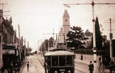
Photograph - PMTT tram 4 Glenferrie Road 1910, possibly undertaking testing prior to the official opening on 30/5/1910. Photo shows the centre of the road overhead support poles in Glenferrie Road and a "Hail Cars Here" sign. In the background is the Malvern Town Hall, signs for Norwich Union and Walter Wright Hairdresser.Yields information about the opening of the tram lines built by the PMTTKodachrome cardboard duplicate slide - Black and white reproduction photograph - PMTT tram 4 Glenferrie Road 1910 "MP5" in penciltrams, tramways, opening, tram 4, pmtt, glenferrie road, tram stop -
Broadmeadows Historical Society & Museum
Photograph - Fatal Accident, Leader newspaper, 16 September 1986
Fatal accident Somerton Road and Hume Highway 1986Event in SomertonPhoto b/w: 17.5 cm x 12 cmObs 17//9/86; P1; Pascoe Vale Road crash Leader Newspaper stampfatal accident, hume highway, somerton road, somerton, broadmeadows observer