Showing 4021 items
matching surveying
-
 City of Moorabbin Historical Society (Operating the Box Cottage Museum)
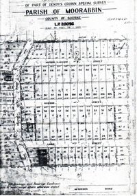
Flyer - Garfield Estate, Ormond
At the end of World War One, there was a renewed interest in residential land and a number of estates opened up in the Municipality of Moorabbin.Example of the progress of the Municipality of MoorabbinPhotocopy of the plan of the Garfield Estate, OrmondPart f Dendy's Crown Special Survey - parish of Moorabbin - County of Bourke - Garfield Estatedraper street, lord street, hudson street, blackshaw street, tucker road, ormond, mckinnon, real estate -
 Bendigo Historical Society Inc.
Map - JACK FLYNN COLLECTION: SALISBURY, 1965
Map: Parish of Salisbury, County of Bendigo. Parish plan.By Authority A. C. Brooks Government Printer, Melbourne. Drawn and Reproduced at the Department of Lands and Survey, Melbourne.map, bendigo, parish plan, salisbury -
 Bendigo Historical Society Inc.
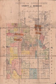
Map - JACK FLYNN COLLECTION: SHELBOURNE, 11/02/1937
Map: Parish of Shelbourne, County of Bendigo. Parish plan.By Authority, H. J.Green, Government Printer. Drawn and Reproduced at the Dept, of Lands and Survey, Melbourne, Victoria.map, bendigo, parish plan, shelbourne -
 Bendigo Historical Society Inc.
Map - JACK FLYNN COLLECTION: MUSKERRY, 1962
Map: Parish of Muskerry, County of Rodney. Parish plan.By Authority: A.C. Brooks, Government Printer, Melbourne. Drawn and reproduced at the Department of Lands and Survey, Melbournemap, rodney, parish plan, muskerry -
 Bendigo Historical Society Inc.
Map - JACK FLYNN COLLECTION: HAYANMI, March 1953
Map: Parish of Hayanmi, County of Bendigo. Parish plan.By Authority: W.M. Houston, Government Printer. Drawn and reproduced at the Dept, of Lands and Survey, Melbourne, Victoriamap, bendigo, parish plan, hayanmi -
 Bendigo Historical Society Inc.
Map - JACK FLYNN COLLECTION: GIRGARRE, 14/10/1943
Map: Parish of Girgarre , County of Rodney. Parish plan. Same map as 10100.20 but in poorer condition.By Authority, H.E.Daw, Government printer Melbourne. Drawn and Reproduced at the Dept, of Lands and Survey, Melbourne, Victoriamap, rodney, girgarre, girgarre, county of rodney -
 Bendigo Historical Society Inc.
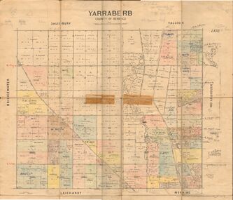
Map - JACK FLYNN COLLECTION: YARRABERB, 2/03/1931
Map: Yarraberb, County of Bendigo. Parish plan.By Authority H.J. Green Govt., Printer. Photo Lithographed at the Department of lands and Survey Melbourne, 2.3.31.map, bendigo, parish plan, yarraberb -
 Bendigo Historical Society Inc.
Map - JACK FLYNN COLLECTION: BEALIBA, 15/09/1931
Map: Parish of Bealiba, County of Gladstone. Parish plan.By Authority H.J. Green, Government Printer. Photo Lithographed at the Government of Lands and Survey Melbourne. 15.9.31map, gladstone, parish plan, bealiba, gladstone -
 Bendigo Historical Society Inc.
Map - JACK FLYNN COLLECTION: BET BET, 18/08/1931
Map: Parish of Bet Bet, Counties of Gladstone and Talbot . Parish plan.By Authority H.J. Green Govt, Printer. Photo Lithographed at the Department of Lands and Survey, Melbourne. 18.8.31map, gladstone, parish plan, bet bet, counties of gladstone and talbot. -
 Bendigo Historical Society Inc.
Map - JACK FLYNN COLLECTION: YARRAYNE, 6/01/1932
Map: Parish of Yarrayne, County of Bendigo. Parish plan.By Authority, H.J. Green, Govt., Printer. Photo-Lithographed at the Department of Lands and Survey, Melbourne. 5.1.32.map, bendigo, parish plan, yarrayne -
 Stawell Historical Society Inc
Map - Parish Map, Barkley County of Kara Kara 1920's, 1920's ?
Johnsons Gully LeadPaper map of Parish of BarkelyBy Authority H.J. Green Govt Printer. Photo Lithographed at the Department of Lands and Survey. Melbourne 22.11.2survey -
 Queenscliffe Maritime Museum
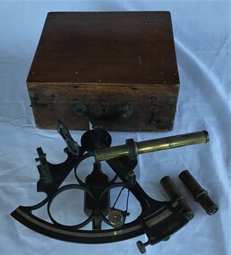
Instrument - Sextant in wooden box
Sextant used by J P Larken, Government Marine SurveyorThe sextant has been the primary position fixing tool of the marine surveyor for 200 years used to measure angles between beacons or points for hydrographic surveys. A sextant in its own wooden box.On inside box lid; 'A. E. Parson surveying and scientific instrument maker, Queen Street, Melbournesextant, jp larken, marine surveyor -
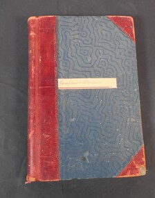 Bendigo Historical Society Inc.
Administrative record - Lands Office Bendigo - Exemptions and Applications
Blue and red hardcover book containing pages of handwritten entries of exemptions and applications to purchase land at various places. The book covers the years 1937 to 1939."Exemptions and Applications" handwritten on label on front cover. Attendance, Lands & Survey in gold letters on the spine.land office, government, land purchases -
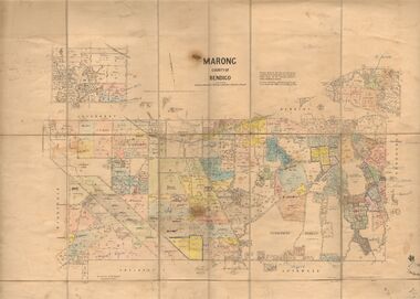 Bendigo Historical Society Inc.
Map - JACK FLYNN COLLECTION: MARONG, June 1933
Map: Parish of Marong, County of Bendigo. Parish plan.By Authority W.M. Houston, Government Printer. Drawn and reporduced at the Dept., of Lands and Survey, Melbourne, Victoria.map, bendigo, parish plan, marong -
 Bacchus Marsh & District Historical Society
Map, Mouyong Parish Map, County of Grant
A single page paper map showing the map for the Parish of Mouyong in the County of Grant. Cadastral map showing land ownership. The map is pasted into a bound volume containing 76 maps or plans in total. High resolution digital image stored on BMDHS computer network. Photo lithographed at the Department of Lands and Survey Melbourne by T. F. McGauran, 9. 4. 07mouyong parish plan, mouyong parish maps, bacchus marsh region parish plans -
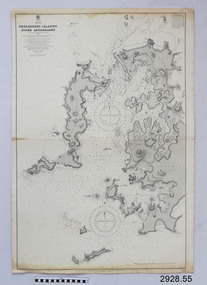 Flagstaff Hill Maritime Museum and Village
Document - Navigation Chart, Pescadores Islands Inner Anchorage
British Admiralty Navigation Chart - China - Formosa Strait - Pescadores Islands Inner Anchorage, from a French Goverment Survey 1886warrnambool, shipwrecked-coast, flagstaff-hill, flagstaff-hill-maritime-museum, maritime-museum, shipwreck-coast, flagstaff-hill-maritime-village, shipwrecked-artefact, navigation chart, british admiralty navigation chart, british admiralty, pescadores islands inner anchorage -
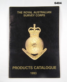 Bendigo Military Museum
Booklet - PRODUCTS CATALOGUE 1993, RASvy Corps, Royal Australian Survey Corps. Products Catalogue1993, 1993
This Catalogue contains details on the products and capabilities available from the RASvy CorpsA4 Booklet black cover, Survey Corps badge in Gold. Sample maps of all products produced by RASvy Corps 1993rasvy, fortuna -
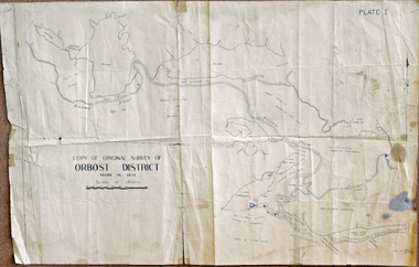 Orbost & District Historical Society
survey, 26th July 1950
This map is a research tool for identifying historical land records in Orbost.A copy of the original survey of Orbost District 1870. White background with black print. The original was hand-drawn in ink. This is PLATE 1.some pen marksmap survey-orbost -
 Bendigo Historical Society Inc.
Document - FORTUNA COLLECTION: ARTICLE: ARMY HEADQUARTERS SURVEY REGIMENT (FORTUNA)
Article re 'Army Headquarters Survey Regiment' (Fortuna) - welcome to an Open Day at Fortuna, 1967. Two handwritten pages (drafts?).bendigo, house, fortuna villa, army headquarters survey regiment. -
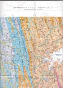 Bendigo Historical Society Inc.
Map - STRUGNELL COLLECTION: GEOLOGICAL SURVEY OF VICTORIA, BENDIGO GOLD FIELD - SPRING GULLY, 1987
Map, Geological Survey of Victoria, Bendigo Gold Field - Spring Gully, Campaspe 10 000 2/1; Victoria 10,000.Cept. Of Industry, Technology & Resources.map, bendigo, spring gully gold field -
Port Melbourne Historical & Preservation Society
Letter - Department of Lands and Survey granting land for temporary reserve, 18 Mar 1860
Handwritten letter from Dept of Lands and Survey granting Crown land for temporary reserve as site for abattoirs 18 March 1861local government - borough of sandridge, industry - noxious, department of lands and surveys, clement hodgkinson -
Tatura Irrigation & Wartime Camps Museum
Booklet, Solving The Mystery, 1978
Story of Tatura Catholic Church and Education. Early history of Tatura 1870's. Present church built in 1912Gold cover, green writing. Survey map on back. Written to explain the first Catholic Church was built at Baldwinsville-Byrneside in 1878.solving the mystery, catholicism in tatura, burton-clay father r, tatura, sacred heart church, books, history, local, religion -
Clunes Museum
Plan
PLAN HAS AN ATTACHED HAND PRINTED CARD WITH INFORMATION REGARDING SITES. THIS HAS BEEN ADDED AT A MUCH LATER DATE.1 PAGE - AN EARLY, UNDATED PLAN OF THE TOWNSHIP OF CLUNES, COUNTY OF TALBOT, SHOWING REDUCED LEVELS AND CHAIN SURVEY OF ALL SECTIONSlocal history, plans -
Whitehorse Historical Society Inc.
Map, Campbell's Croft, c1970
Enlarged aerial photograph of the area around Campbell's Croft Reserve. State aerial Survey, Melbourne, 1970 project. Run 37Enlarged aerial photograph of the area around Campbell's Croft Reserve. State aerial Survey, Melbourne, 1970 project. Run 37Enlarged aerial photograph of the area around Campbell's Croft Reserve. State aerial Survey, Melbourne, 1970 project. Run 37campbells croft, boronia road, vermont, madonna court, vermont, aerial photographs -
Whitehorse Historical Society Inc.
Document, The Place Names Committee
A report on an address given on 'The Place Names Committee' by Mr H.S. McComb - he is eminent in many fields, especially the survey world.A report on an address given on 'The Place Names Committee' by Mr H.S. McComb - he is eminent in many fields, especially the survey world.A report on an address given on 'The Place Names Committee' by Mr H.S. McComb - he is eminent in many fields, especially the survey world.place names committee, mccomb, h.s. -
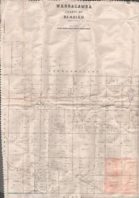 Bendigo Historical Society Inc.
Map - MAP. WARRAGAMBA. COUNTY OF BENDIGO, 1915
Map. Warragamba. Colunty of Bendigo. Pannoomilloo. Minto. Diggorra. Kamarooka Photographedat the Department of LANDS AND Survey Melbourne by W. J. Butson. -
Canterbury History Group
Document - Elgar's Special Survey, part of, 1990
Photocopy of part of Elgar's Special Survey relating to the area between Mont Albert Road, Rochester Road and Faversham Road Canterburycanterbury, mont albert road, rochester road, faversham road, elgar's special survey, creeks -
 Whitehorse Historical Society Inc.
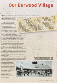
Article - The Bulletin newsletter, The Bulletin Jun - Aug 2022, Our Burwood Village, June 2022
An article about the first settlement surveyed in 1858 in the Burwood area known as Ballyshanassy. It later became Norwood and finally Burwood in 1879.An article about the first settlement surveyed in 1858 in the Burwood area known as Ballyshanassy. It later became Norwood and finally Burwood in 1879.An article about the first settlement surveyed in 1858 in the Burwood area known as Ballyshanassy. It later became Norwood and finally Burwood in 1879.ballyshanassy, albers ernest, boundary road burwood east, dempsey -
 Bendigo Historical Society Inc.
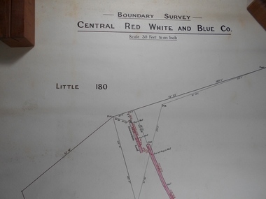
Administrative record - Central Red White and Blue
Draftsman's drawing Boundary Survey Central Red White and Blue Map Forms part of the Margaret Roberts Collection of mining records.bendigo, margaret roberts, gold, map, mine, central red white and blue -
Lakes Entrance Historical Society
Book, Reed, G.H. M.A, A Book of Architecture, 1930
A survey of architecture through the ages, with illustrations describing styles, ornamentation and historical development. A short reference to Sir Christopher Wren is included.Ruth Clarkarchitecture, social history, religion, arts