Showing 2472 items matching " township"
-
 Eltham District Historical Society Inc
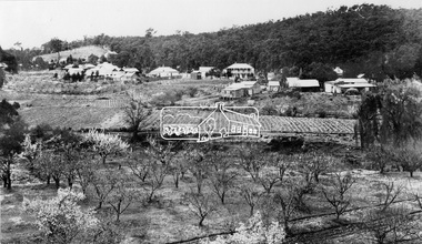
Photograph, View at Hurstbridge, 1924
View of Hurstbridge township overlooking fruit trees in flower in the foregaround and ploughed paddocks ready for crop planting in the middle of the photo.This photo forms part of a collection of photographs gathered by the Shire of Eltham for their centenary project book, "Pioneers and Painters: 100 years of the Shire of Eltham" by Alan Marshall (1971). The collection of over 500 images is held in partnership between Eltham District Historical Society and Yarra Plenty Regional Library (Eltham Library) and is now formally known as The Shire of Eltham Pioneers Photograph Collection.' It is significant in being the first community sourced collection representing the places and people of the Shire's first one hundred years.Digital imagesepp, shire of eltham pioneers photograph collection, hurstbridge, orchard, fruit trees -
 Sunbury Family History and Heritage Society Inc.
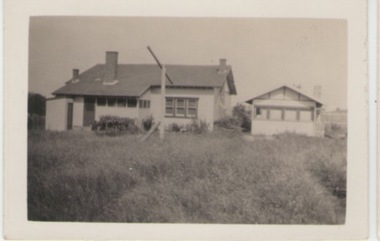
Photograph, c1920s - 1930s
In the 1920s a few Californian style homes were built in the township of Sunbury and some of them can still be seen in the town.A black and white photograph of the rear view of a weatherboard Californian style bungalow built in an open paddock. The house also has a smaller building on the RHS and an outdoor toilet as well as a double clothes line are in the yard. sunbury township. -
 Stawell Historical Society Inc
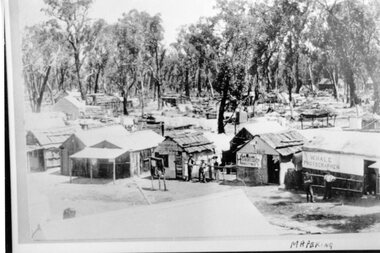
Photograph, Mafeking Goldfield at Mt William with Photographer, Hairdresser and other buildings c1900
Mafeking Goldfield Mt William Mining Scene c1900. Businesses in township. W Hale Photographer. Hairdresser and other buildings. stawell -
 Clunes Museum
photograph, KODAK
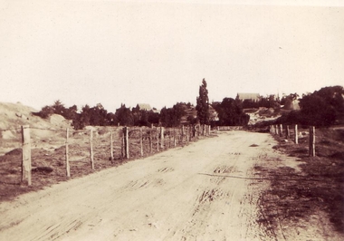
VIEW OF GRAVEL ROAD FROM CLUNES TOWNSHIP TO STATION FLAT. LOWER PART OF PORT PHILLIP MINE ON LEFT OF PHOTO.VIEW OF ROAD LEADING TO STATION FLAT, CLUNES - ANGLICAN CHURCH ON HILL IN BACKGROUNDlocal history, clunes landscape. -
 Bendigo Historical Society Inc.
Map - CAMPBELL COLLECTION: BENDIGO AND DISTRICT MAPS, 10-5-29
Map. Mandurang, Scale 20 chains to an inch. Total area 5746 acres. Kennington, Township of Mandurang. To accompany my report of 10-5-29 R. Marshall, Forest assessor. Drawn by I.M.K. (number 399 in map cupboard 1)I.M.K.map, bendigo, allotments -
Clunes Museum
Photograph
FIVE PHOTOGRAPHS OF HISTORIC CLUNES. FIVE VIEWS FROM THE PAST. 1.CLUNES IN THE EARLY SIXTIES, 2. TOWNSHIP OF CLUNES FROM THE ROCKS, 3. CLUNES HOSPITAL,4.CLUNES TOWN HALL AND COURT HOUSE, 5. BUTTER FACTORY, CLUNES.local history, photographs, clunes buildings -
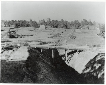 Buninyong & District Historical Society
Photograph - Photo of Original Photograph, W. Jack, Buninyong Railway Station precinct in 1940, 9 June 1940
Railway station and surrounds in 1940.B/W photograph f Buninyong Railway station precinct, taken 9 June 1940, showing Barkly St. trestle bridge over railway cutting, Butter Factory on left, station and rail yards on left, township to thye right.buninyong, railway, bunny, butter factory, bridge, cutting, barkly st. -
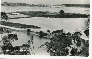
 Lakes Entrance Historical Society
Photograph - Lakes Entrance, Gippsland Ports, 2006 c
Second copyColour aerial photograph of entrance from Bass Strait to Gippsland Lakes including Bullock Island Reeves Channel Rigby Island houses on Kalimna Hill and Princes Highway winding down Jemmys Point hill into township of Lakes Entrance Victoriaaerial photograph, ocean, waterways -
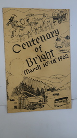 Kiewa Valley Historical Society
Booklet - Bright, Centenary of Bright March 10th - 18th, 1962
Township of Bright celebrated its centenary during the week from 10th - 18th March, 1962. This booklet outlines the program for the week.Bright is a nearby town to the the Kiewa Valley and currently the location of the current Shire (Alpine). The program gives historical information on activities in the early 1960s.Yellowy/Orange cover with brown title and sketch. One sketch is at the bottom and includes hills, pines, saw mill and bus. Sketch at the top is of a bullock team and in the middle on the right a gold miner. Inside cover has print as has both sides of the 4 pages held by 2 staples. 'C. Roper' on inside of the front cover.bright, centenary of bright -
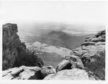 Halls Gap & Grampians Historical Society
Photograph, C 1960s
The valley is known as Fyans Valley and the township of Halls Gap. Photo is typical of those taken by the Forestry Commission (Vic) during the 1960s.Photo shows two rocky outcrops in the foreground framing a valley in the distance below. A partial view of a mountain range flanks the valley. Plains of trees and open fields, and also a lake, can be seen beyond the mountain range. Within the valley in the middle of the photo buildings, roads and cleared land can be seen.scenery, fyans valley -
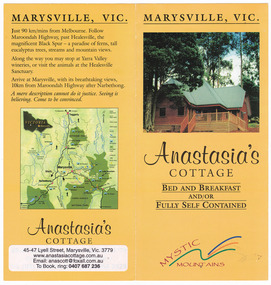
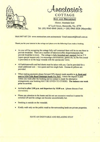 Marysville & District Historical Society
Ephemera (Item) - Reservation form, Anastasia's COTTAGE, Unknown
An information and reservation form for Anastasia's Cottage in Marysville. This cottage, along with most of the buildings in the township, was destroyed in the 2009 Black Saturday bushfires.An information and reservation form for Anastasia's Cottage in Marysville.marysville, victoria, australia, reservation form, accommodation, anastasia's cottage, 2009 black saturday bushfires -
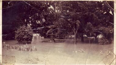 Clunes Museum
Photograph, FLOODS 1934
AFTER HEAVY RAINS - CRESWICK CREEK IN CLUNES TOWNSHIP FLOODED, OVER FLOWING ITS BANKS, NEAR BY AREAS WERE SUBMERGED.BLACK AND WHITE SMALL PHOTOGRAPH OF CLUNES FLOODS IN 1934. CLUNES QUEEN'S PARK WITH FOUNTAIN UNDER WATER - TREES IN THE BACKGROUND AND A FEW FLOWERS IN THE FOREGROUND.local history, queen's park garden., floods 1934 -
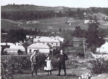 Greensborough Historical Society
Photograph, Diamond Creek
This undated view of Diamond Creek shows three children on a hill looking over a small township with open fields and trees in background. Large black and white photograph of a view over a town and rural landscape.diamond creek, country life -
 Ballarat Tramway Museum
Photograph - Colour Photograph/s - set of 8, Carolyn Dean, 22/11/2000 12:00:00 AM
Set of eight colour prints of the Ballarat COTMA Conference 2000 visits to the MTPA depot at Haddon, the township of Clunes and to CMR Muckleford Photographed on 22/11/2000 at Haddon and on 23/11/2000 at Clunes and Muckleford. Photographs by Carolyn Dean. .1 - No. 663, 670 and 407 at Haddon MTPA depot .2 - COTMA delegates at Haddon BBQ .3 - No. 407 on operating track at Haddon .4 - Clunes war memorial .5 - Clunes township main street .6 - Muckleford station nameboard .7 - J549 at Muckleford station .8 - ditto Printed on Kodak paper.On rear of each print is "263.3 or .4, or .5" and date "22.11.00" or "23.11.00" in ink.btm, haddon, cotma, muckleford, clunes, tram 663, tram 670, tram 407 -
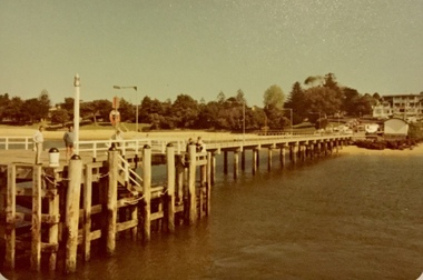 Phillip Island and District Historical Society Inc.
Photograph, Cowes jetty and Matthew Brady ferry, About 1980
Coloured photograph of the Cowes jetty, taken from the water, showing several men standing on the jetty and others fishing. Cowes township in the background. Coloured photograph of the passenger ferry, Matthew Brady at the Cowes jetty. A large number of passengers inside and on the top deck.cowes jetty, photographs, cowes, ferries, ferry matthew brady -
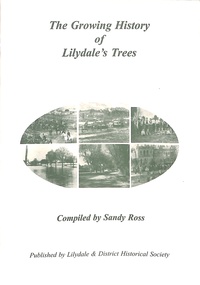 Ringwood and District Historical Society
Book, The Growing History of Lilydale's Trees, Circa 2010
Soft cover book by Sandy Ross - Lilydale & District Historical Society. Year by year summary of tree planting activities and ceremonies in Lilydale (Victoria) from 1897 to 1920. Includes several black and white photographs of township's streetscapes and Arbor Day celebrations. -
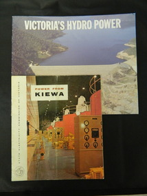 Kiewa Valley Historical Society
Booklets - Kiewa Hydro Electric Scheme, 1. "Power From Kiewa" and 2. "Victoria's Hydro Power", 1. Made in July 1968 and 2. Made in Aug. 1985
1. The State Electricity Commission of Victoria built the Kiewa Hydro Electric Scheme from the 1930's to the 1960's. This booklet was to inform visitors and to promote tourism. 2. The State Electricity Commission built several hydro power stations from 1928 - 1981. This booklet names each with a summary and explanation.The State Electricity Commission of Victoria built the Kiewa Hydro Electric Scheme establishing infrastructure such as the Bogong and Mt Beauty townships and the opportunity for tourism in the area.1. Colored soft cover with photo of McKay Creek Power Station on the front and Mt Beauty township on the back. Published by the SECV 2. Colored soft cover with Rocky Valley Dam on the front and inserted photo of a stream and snow on the back. Published by the SEC.state electricity commission of victoria; kiewa hydro electric scheme; victoria's hydro electric power; kiewa; mckay creek power station; clover power station; west kiewa power station -
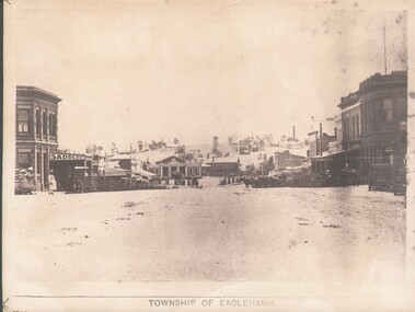 Bendigo Historical Society Inc.
Photograph - WES HARRY COLLECTION: TOWNSHIP OF EAGLEHAWK, C. 1860's
Sepia photograph of the Township of Eaglehawk, looking down the hill from about Victoria St. Visible are the Victoria Hotel and the Exchange Hotel on the left hand side of the photo. At the bottom of the hill there is the old Town Hall and in the distance on the hill is one of the Virginia Reef mines.place, eaglehawk, streetscape, eaglehawk, victoria hotel, exchange hotel, virginia reef -
Tatura Irrigation & Wartime Camps Museum
Book, Girgarre Living History, Girgarre. Girgarre Living History, 2016
Girgarre - an extraordinary history, closer settlement, soldier settlement and family stories.Tells of the history of Girgarre, with information obtained from a collection of stories and extensive research into the Closer and Soldier Settlement of the districtRectangular shaped book ,aerial photo of the township and environs of Girgarre, on Market Day, September 2013. Photo extends over front & back covers, highly colourful cover. 251 pages. B/W photos and maps of local families and local scenes.girgarre, family histories, soldier settlement -
Tatura Irrigation & Wartime Camps Museum
Book, Girgarre Living History, Girgarre. Girgarre Living History, 2016
Girgarre - an extraordinary history, closer settlement, soldier settlement and family stories.Tells of the history of Girgarre, with information obtained from a collection of stories and extensive research into the Closer and Soldier Settlement of the districtRectangular shaped book ,aerial photo of the township and environs of Girgarre,on Market Day, September 2013. Photo extends over front & back covers, highly colourful cover. 251 pages ,B/W photos and maps of local families and local scenes.girgarre, family histories -
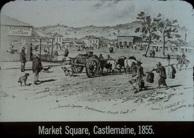 Bendigo Historical Society Inc.
Slide - DIGGERS & MINING. GOLD, c1855
Diggers & Mining. Gold. Market Square Castlemaine, Forest Creek. James J Bundell & Co, Melbourne 1855. Shows the small township, people wagons, dogs. Market Square Castlemaine, 1855. Markings: 26 994.GOL. Used as a teaching aid.hanimounteducation, tertiary, goldfields -
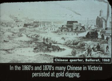 Bendigo Historical Society Inc.
Slide - DIGGERS & MINING. THE CHINESE ON THE GOLD FIELDS, c1868
Diggers & Mining. The Chinese on the Gold Fields. Slide: Chinese quarter, Ballarat, 1868. In the 1860s and 1870s many Chinese in Victoria persisted at gold digging. Slide shows township and Chinese along the creek looking for gold. Markings: 13. Used as a teaching aid.hanimounteducation, tertiary, goldfields -
 Lakes Entrance Historical Society
Postcard - Bullock Island, 1920c
1 x Faded miniature postcard 6.5 x 8.5|1 x Black and white 9.5 x 12 copied from album in private hands|1 x Sepia toned 10 x 15|1 x Black and white 12 x 17.5Black and white small format postcard of Bullock Island. It shows the approaches to the concrete North Arm Bridge over North Arm, the footbridge to Bullock Island, the entrance to the Gippsland Lakes from Bass Strait and part of the township on the hummocks. Lakes Entrance VictoriaLakes Entrancewaterways, topography, islands, bridges -
 Marysville & District Historical Society
Ephemera (Item) - Information brochure, Anastasia's COTTAGES, Unknown
An information brochure regarding Anastasia's Cottages in Marysville. These cottages, along with most of the buildings in the township, were destroyed in the 2009 Black Saturday bushfires.An information brochure regarding Anastasia's Cottages in Marysville.marysville, victoria, australia, anastasia's cottages, information brochure, accommodation, 2009 black saturday bushfires -
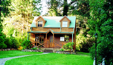 Marysville & District Historical Society
Photograph (Item) - Colour photograph, Unknown
A colour photograph of Ashlar Cottage B&B in Marysville. This cottage, along with the majority of the buildings in the township, was destroyed in the 2009 Black Saturday bushfires.A colour photograph of Ashlar Cottage B&B in Marysville.marysville, victoria, australia, accommodation, ashlar cottage b&b, 2009 black saturday bushfires, photograph -
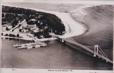 Phillip Island and District Historical Society Inc.
Photograph, Phillip Island Bridge, 1940
The bridge built around 1939. Fishing fleet. Twin jetties to left of bridge, township, bush and wide sand strip of surf beach.Bridge between Phillip Island and San Remo. Photograph depicting San Remo onlyNo. 1. Phillip Island Bridge, Vic. Airspy Photolocal history, photographs, bridges, san remo, coastline, bridge, fishing fleet, jetties, bruce bennett -
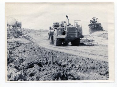 Orbost & District Historical Society
black and white photographs, C1975
These four photographs show the construction of the Princes Freeway on the eastern edge near the cemetery. of the Orbost township. The road is from the eastern entrance to the cemetery.These photographs are pictorial records of the construction of roads in Orbost.Four black / white photographs of road construction machinery.road-construction-orbost roadwork-orbost-cemetery -
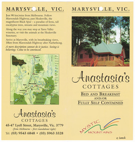 Marysville & District Historical Society
Ephemera (Item) - Information brochure, Anastasia's COTTAGES, Unknown
An information brochure regarding Anastasia's Cottages in Marysville. These cottages, along with most of the buildings in the township, were destroyed in the 2009 Black Saturday bushfires.An information brochure regarding Anastasia's Cottages in Marysville.marysville, victoria, australia, anastasia's cottages, information brochure, accommodation, 2009 black saturday bushfires -
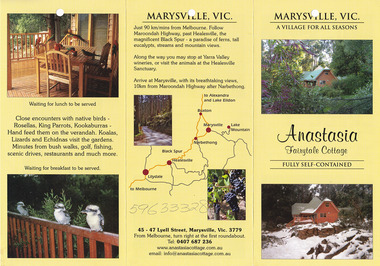 Marysville & District Historical Society
Ephemera (Item) - Information brochure, Anastasia Fairytale Cottage, Unknown
An information brochure regarding Anastasia Fairytale Cottage in Marysville. This cottage, along with most of the buildings in the township, was destroyed in the 2009 Black Saturday bushfires.An information brochure regarding Anastasia Fairytale Cottage in Marysville.marysville, victoria, australia, information brochure, accommodation, anastasia fairytale cottage, 2009 black saturday bushfires -
Donald History and Natural History Group operating the Donald Court House Museum
Tool #1
This wooden handle tool was used by Georgie Ah Ling, who operated a market garden on the edge of the township of Donald for over 70 years.Rounded conical shaped wooden handle with metal pointed needle.tool, wooden handle, georgie ah ling, market garden, donald