Showing 2559 items
matching aerial
-
 Federation University Historical Collection
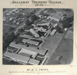
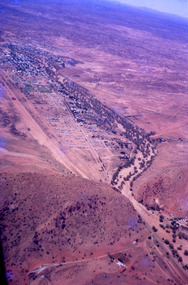
Photograph - Photograph - Black and White, Ballarat Teachers' College, Gillies Street, 1961, 1961
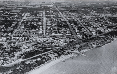
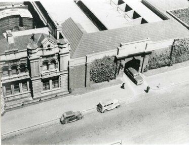
The Ballarat Teachers' College was established after the Victorian State Government and the State Education Department decided to establish two provincial teachers' colleges, at Ballarat and Bendigo. On 04 May 1926 W.H. Ellwood (Principal), Miss A. Bouchier, and Mr A.B. Jones, welcomed the first enrolment of 61 students to undertake the one year course. In 1927 the College moved to the former Ballarat East Town Hall in Barkly Street, which was remodelled for their use. It closed in December 1931 due to the Great Depression. In 1946 Ballarat Teachers' College reopened and relocated to the Dana Street State School. The building used by the Teachers' College was the original bluestone building facing Doveton Street South. It was originally planned to open as a women's college, for whom the residence at 130 Victoria Street was purchased, but the decision was made to admit resident men from Ballarat. Mr T.W. Turner was appointed as Principal in 1951 and directed the introduction of a two year course for the Trained Primary Teachers' Certificate. The former one year course was terminated at the end of 1951. In 1958 the College was relocated to a custom built facility at Gillies Street, in close proximity to the Ballarat Botanical Gardens. Numbers increased with the introduction of the Trained Infant Teachers' Certificate course under the guidance of Mary Egan. With the introduction of a three year Diploma Course in 1968 accommodation became cramped. The introduction of the Diploma of Teaching (Primary) led to the Trained Infant Teachers' Certificate being discontinued in 1969, and the end of the Trained Primary Teachers' Certificate in 1969. Secondary Art and Craft students began studies at Ballarat Teachers' College in 1969 under Mr Ted Doney. In 1971 Mr D. Watson was appointed Principal. The State College of Victoria was proclaimed by Order in Council on 24 July 1973, and Ballarat Teachers' College became a constituent college of the State College of Victoria, and was known as State College of Victoria, Ballarat. By 1975 the College moved to Mount Helen as part of the Ballarat College of Advanced Education. Pre service teachers currently undertake their studies on the Mount Helen Campus of Federation University. ("Ruffians Attempted to Carry of the School Tent: A History of State Education in Ballarat", 1974, p73-4.) Aerial photograph of the Gillies Street Campus of Ballarat Teachers' College glued onto card."Ballarat Teachers' College 1961 presented to R.J. Croft by the boys of the RSL Youth Club, as a token of appreciationballarat teachers' college, r.j. croft, rsl youth club -
 Glenelg Shire Council Cultural Collection
Photograph - Photograph - aerial view of Portland, n.d
Port of Portland Authority Archivesport of portland archives, aerial photography, portland harbour, k s anderson wharf -
Glenelg Shire Council Cultural Collection
Photograph - Photograph - aerial view of Portland, n.d
Port of Portland Authority Archivesport of portland archives, aerial photography, portland harbour -
Glenelg Shire Council Cultural Collection
Photograph - Photograph - aerial view of Portland, n.d
Port of Portland Authority Archivesport of portland archives, aerial photography, portland harbour -
 Glenelg Shire Council Cultural Collection
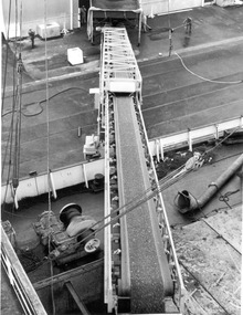
Photograph - Photograph - aerial view of Lucerne pellets loaded onto ship, 1972
Port of Portland Authority archivesFront: (no inscriptions) Back: (no inscriptions)port of portland archives, cargo, cargo handling, portland harbour, japanese cargo -
Glenelg Shire Council Cultural Collection
Photograph - Photograph - Main Breakwater Construction, n.d
Port of Portland Authority Archivesport of portland archives, portland harbour, main breakwater, construction, aerial photo -
Glenelg Shire Council Cultural Collection
Photograph - Photograph - Main Breakwater construction, Portland, 17/11/1958
Port of Portland Authority ArchivesFront: Purplestamp- '17 Nov 1958' L81-Pencil Back: Purple stamp- '17 Nov 1958' L81 - Pencilport of portland archives, main breakwater, construction, harbour development -
Glenelg Shire Council Cultural Collection
Photograph - Photograph - View of Portland Harbour, c. 1974
Port of Portland Authority archives.Front: (no inscriptions) Back: (no inscriptions)port of portland archives, portland harbour -
Glenelg Shire Council Cultural Collection
Photograph, n.d
Port of Portland Authority Archivesport of portland -
 National Vietnam Veterans Museum (NVVM)
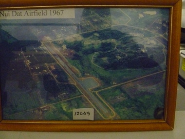
Photograph, Nui Dat Airfield 1967
Framed coloured aerial photo of Nui Dat Airfield depicting runway and surrounding infrastructure.Nui Dat Airfield 1962nui dat airfield, photograph -
Tatura Irrigation & Wartime Camps Museum
Photograph - aerial, Qasco Vic Images, Tatura, 7 March 2002
Large aerial photograph of town of Tatura and approx. 3 kms out. Colour, laminated.aerial photographs tatura -
 Robin Boyd Foundation
Slide, Robin Boyd, 1966
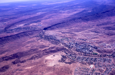
Robin Boyd was appointed Exhibits Architect for the Australian Pavilion at Expo ‘67 in Montreal. In 1966 Boyd travelled to Far North Queensland and the Northern Territory for research – the Expo exhibits included a coral display, a large rock feature made from Australian sandstone and a native plant garden.Colour slide in a mount. Aerial view over Alice, Springs, Northern Territory, AustraliaMade in Australia / 9 / DEC 66M4 / Encircled 78 (Handwritten)australia, slide, robin boyd -
 Robin Boyd Foundation
Slide, Robin Boyd, 1966
Robin Boyd was appointed Exhibits Architect for the Australian Pavilion at Expo ‘67 in Montreal. In 1966 Boyd travelled to Far North Queensland and the Northern Territory for research – the Expo exhibits included a coral display, a large rock feature made from Australian sandstone and a native plant garden.Colour slide in a mount. Aerial view on the way to Alice Springs, Northern Territory, AustraliaMade in Australia / 32 / DEC 66M4 / Encircled 3 (Handwritten)australia, slide, robin boyd -
 Robin Boyd Foundation
Slide, Robin Boyd, 1966
Robin Boyd was appointed Exhibits Architect for the Australian Pavilion at Expo ‘67 in Montreal. In 1966 Boyd travelled to Far North Queensland and the Northern Territory for research – the Expo exhibits included a coral display, a large rock feature made from Australian sandstone and a native plant garden.Colour slide in a mount. Aerial view on the way to Alice Springs, Northern Territory, AustraliaMade in Australia / 12 / DEC 66M4northern territory, slide -
 Robin Boyd Foundation
Slide, Robin Boyd, 1966
Robin Boyd was appointed Exhibits Architect for the Australian Pavilion at Expo ‘67 in Montreal. In 1966 Boyd travelled to Far North Queensland and the Northern Territory for research – the Expo exhibits included a coral display, a large rock feature made from Australian sandstone and a native plant garden.Colour slide in a mount. Aerial view on the way to Alice Springs, Northern Territory, AustraliaMade in Australia / 33 / DEC 66M4northern territory, slide -
 Robin Boyd Foundation
Slide, Robin Boyd, 1966
Robin Boyd was appointed Exhibits Architect for the Australian Pavilion at Expo ‘67 in Montreal. In 1966 Boyd travelled to Far North Queensland and the Northern Territory for research – the Expo exhibits included a coral display, a large rock feature made from Australian sandstone and a native plant garden.Colour slide in a mount. Aerial view on the way to Alice Springs, Northern Territory, AustraliaMade in Australia / 34 / DEC 66M4northern territory, slide -
 Robin Boyd Foundation
Slide, Robin Boyd, 1966
Robin Boyd was appointed Exhibits Architect for the Australian Pavilion at Expo ‘67 in Montreal. In 1966 Boyd travelled to Far North Queensland and the Northern Territory for research – the Expo exhibits included a coral display, a large rock feature made from Australian sandstone and a native plant garden.Colour slide in a mount. Aerial view on the way to Alice Springs, Northern Territory, AustraliaMade in Australia / 8 / DEC 66M4northern territory, slide -
Whitehorse Historical Society Inc.
Map, Whitehorse Road, Mitcham, 1972
Enlarged aerial photograph of area around intersection of Whitehorse Road and Heatherdale Roads, Mitcham.Enlarged aerial photograph of area around intersection of Whitehorse Road and Heatherdale Roads, Mitcham.Enlarged aerial photograph of area around intersection of Whitehorse Road and Heatherdale Roads, Mitcham.whitehorse road, mitcham, heatherdale road, mitcham, ringwood, maroondah highway, aerial photographs -
Whitehorse Historical Society Inc.
Map, Burwood Highway, c1970
Enlarged aerial photo of area South of Burwood Highway to Dandenong Creek, Vermont South.Enlarged aerial photo of area South of Burwood Highway to Dandenong Creek, Vermont South.Enlarged aerial photo of area South of Burwood Highway to Dandenong Creek, Vermont South.dandenong creek, morack road, vermont south, burwood highway, vermont south, aerial photographs -
Whitehorse Historical Society Inc.
Map, Springvale Road, 1968
Aerial photograph of cnr Springvale Road and Burwood Highway, south past Highbury Road.Aerial photograph of cnr Springvale Road and Burwood Highway, south past Highbury Road.Aerial photograph of cnr Springvale Road and Burwood Highway, south past Highbury Road.aerial photographs, highbury road, burwood east, burwood highway, burwood east, springvale road, burwood east -
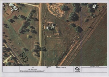 Rutherglen Historical Society
Image, Indigo Shire Council, 28/10/2009
When operational, the Gold Battery used cyanide in its processing processes. The land surrounding it required remediation before it could be handed over to Indigo Shire for public use. The land has since been planted with pasture and native plants. The Gold Battery has been restored to working condition, and can be viewed by collecting a ticket from the Rutherglen Wine Experience and Visitor Information Centre.Laminated aerial photograph of Gold Battery site, believed taken before land remediation.gold battery, gold processing -
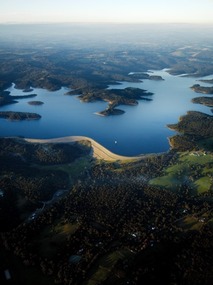 Southern Sherbrooke Historical Society Inc.
Photograph - Cardinia Reservoir from the air
Aerial photograph of Cardinia Reservoir taken in 2020, showing the face of the main dam wall. -
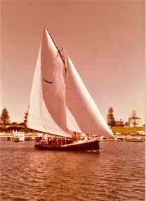 Queenscliffe Maritime Museum
photograph - Photo of Couta boat AERIEL at Portland, AERIEL at Portland, 1986
Couta boatsGarry Kerr's Couta boat AERIAL at Portland, under sail.5 x Colour photographs of the Couta boat AERIAL, owned by Garry Kerr, at PortlandReverse - " NIL "historical references -
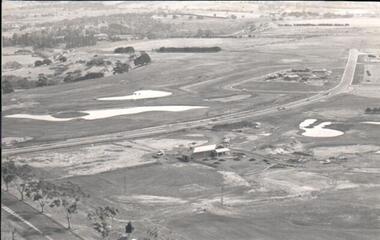 Hume City Civic Collection
Photograph
A black and white aerial photograph of an aerial view of the newly established Goonawarra Golf Club. Sunbury Road is visible in the bottom LH corner and Francis Avenue crosses the photograph. The clubhouse is in the centre of the photograph and some early housing development is in the distance.goonawarra gold club, housing developments, regional newspaper, george evans collection -
 Bayside Gallery - Bayside City Council Art & Heritage Collection
Photograph, W.H. Hansom, Sandringham, 1921
sandringham, aerial, coast, bathing box, w.h. hansom, victoria, suburbs, photograph, airspy, beach street, bay road, abbott street, sandringham hotel -
 Bendigo Military Museum
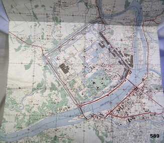
Map - MAP HUE VIETNAM, C.1960’s
The city of Hue is in South Vietnam. The map was used by a member of the AATTV during the Tet Offensive in Thau Thien province. Map brought home from Vietnam by Murray Stanley Metherall. Refer 590.2.Colour printed map of Hue Citadel on paper. Aerial view of land, river and building outlines.hue, vietnam, tet -
 Phillip Island and District Historical Society Inc.
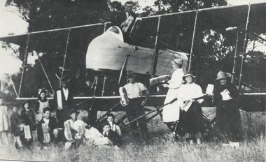
Photograph, 1921
One of a collection of over 400 photographs in an album commenced in 1960 and presented to the Phillip Island & Westernport Historical Society by the Shire of Phillip IslandPhotograph of the aeroplane and the first aerial delivery of bread at Rhylstone Park, Cowes Phillip Island, 1921local history, photography, aeroplane delivering bread, black & white photograph, aeroplanes, aerial bread delivery, john jenner, bryant west -
 Phillip Island and District Historical Society Inc.
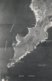
Photograph, R.A.A.F, 1939
One of a collection of over 400 photographs in an album commenced in 1960 and presented to the Phillip Island & Westernport Historical Society by the Shire of Phillip IslandAerial Photograph of the western end of Phillip Island taken by the RAAF in 1939 from 13,000 feet.local history, photography, aerial photograph of summerland island, black & white photograph, coastline, beaches, the nobbies, john jenner, bryant west -
Glenelg Shire Council Cultural Collection
Photograph - Photograph - Cape Grant Quarry, 24/01/1968
Port of Portland Authority ArchivesBack: 'JAN 24, 1968 ' - pencil top rightport of portland archives, cape grant quarry -
 Victoria Police Museum
Photograph (police car), Kodak
Aerial photograph of Single Spinner Ford leaving Russell Street police garage, circa 1950police vehicles; transport branch; wireless patrol; motor police branch; motor traffic section; ford single spinner car; russell street