Showing 1568 items
matching documents - maps
-
 Whitehorse Historical Society Inc.
Document, My memories of the area around Simpson Park, 1/10/2003 12:00:00 AM
Memories with promptings from Jack Leach who lived in Rupert Street and later in Creek Road.Memories with promptings from Jack Leach who lived in Rupert Street and later in Creek Road. Describes that part of Mitcham south of the railway line between Creek Road and Cochrane street. A sketch map of the area as it was in the 1930's is also supplied.Memories with promptings from Jack Leach who lived in Rupert Street and later in Creek Road.brunswick road, mitcham, creek road, mitcham, cochrane street, mitcham, rupert street, mitcham, bloom family, leach, jack, leach family, simpson family, ferris, ray, simpson park -
Whitehorse Historical Society Inc.
Document, Gordon Hildesley Neve, 3/10/1975 12:00:00 AM
... ) 12 Nara Road. With map. Gordon Hildesley Neve Document ...Letter, 3 Oct 1975 from Mr Neve and copy of 1858 agreement with Box Hill Council relating to connection of electricity to his home at 39 Wattle Valley Road Mitcham,Letter, 3 Oct 1975 from Mr Neve and copy of 1858 agreement with Box Hill Council relating to connection of electricity to his home at 39 Wattle Valley Road Mitcham, later (1975) 12 Nara Road. With map.Letter, 3 Oct 1975 from Mr Neve and copy of 1858 agreement with Box Hill Council relating to connection of electricity to his home at 39 Wattle Valley Road Mitcham,electricity supply, neve, gordon hildesley, city of box hill, mitcham, wattle valley road, nara road, cook street, burnett street, sharrow road -
Whitehorse Historical Society Inc.
Document, Street names, 1989
Artic;le by Gwenda Trethewy, member of Nunawading Historical SocietyArtic;le by Gwenda Trethewy, member of Nunawading Historical Society, on the history of the Mitcham street names, Endeavour, Flinders, Moresby and Beaufort, Oct - Dec 1989 and map of the area and an extract of the article.Artic;le by Gwenda Trethewy, member of Nunawading Historical Societystreet names, trethewey, gwenda, turner, (commander), nunawading historical society, endeavour street, mitcham, flinders street, mitcham, moresby street, mitcham, beaufort street, mitcham -
 Whitehorse Historical Society Inc.
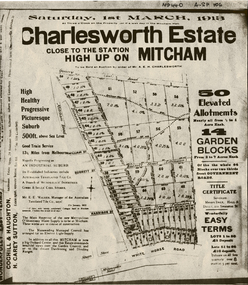
Document, Charlesworth Estate, 1913
Charlesworth Estate, Mitcham. 50 elevated allotments, 1/2 to 1 acre each and 14 garden blocks from 2 to 7 acres each. 1 March 1913.Brochure for auction of Charlesworth Estate, Mitcham. 50 elevated allotments, 1/2 to 1 acre each and 14 garden blocks from 2 to 7 acres each. 1 March 1913. Agents: Coghill & Houghton and H. Carey Sutton.Charlesworth Estate, Mitcham. 50 elevated allotments, 1/2 to 1 acre each and 14 garden blocks from 2 to 7 acres each. 1 March 1913.auctions, charlesworth estate, mitcham, quarry road, doncaster east road, burnett street, harrison street, whitehorse road -
 Whitehorse Historical Society Inc.
Document, Mitcham, ca 1920
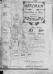
Brochure for auction of 70 sites bounded by Mitcham, Doncaster East and Whitehorse Roads on 1 May ?1920.Brochure for auction of 70 sites bounded by Mitcham, Doncaster East and Whitehorse Roads on 1 May ?1920. Agents: T.R.B. Morton & Sons, Coghill & Haughton.|The home/hospital shown on brochure in Harrison Street near Mitcham Road owned by Dr Drake and later Dr Cochrane was called 'Coombe-Wood'Brochure for auction of 70 sites bounded by Mitcham, Doncaster East and Whitehorse Roads on 1 May ?1920.auctions, doncaster east road, mitcham, whitehorse road, mitcham road, mcdowall street, burnett street, t.r.b. morton & son, coghill & haughton, william street, harrison street, drake, francis, john, dr -
 Whitehorse Historical Society Inc.
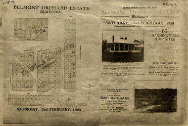
Document, Belmont Orchard Estate, 1924
Brochure for auction of Belmont Orchard Estate, BlackburnBrochure for auction of Belmont Orchard Estate, Blackburn, (now Nunawading) 66 sites, 2 February 1924. Agents: Coghill & Haughton, Frank Fisher.Brochure for auction of Belmont Orchard Estate, Blackburnauctions, belmont orchard estate, patterson street, nunawading, central road, joyce street, lilian street, west avenue -
![Brochure for auction of Eastdawn Estate, Mitcham, 70 lots [20 February 1915]](/media/collectors/56f368632162f118acbff12e/items/60d923316e5f99545134e472/item-media/60d9477c6e5f995451350fb8/item-fit-380x285.jpg) Whitehorse Historical Society Inc.
Whitehorse Historical Society Inc.Document, Eastdawn Estate, 1915
Brochure for auction of Eastdawn Estate, Mitcham, 70 lots [20 February 1915]Brochure for auction of Eastdawn Estate, Mitcham, 70 lots [20 February 1915]. Agents Coghill & Haughton.Brochure for auction of Eastdawn Estate, Mitcham, 70 lots [20 February 1915]auctions, eastdawn estate, mother foster's estate, mitcham road, mitcham, orient avenue, hull parade, vernal avenue -
Whitehorse Historical Society Inc.
Document, Eastern Freeway Extension, 2000 - 2002
... Precinct - Concept Plan VicRoads maps. Eastern Freeway Extension ...Eastern Freeway ExtensionEastern Freeway Extension- Cost estimates for community consultation option Public consultation process : report on analysis submissions Deep Creek Road - Landscape concept Media Release from Premier of Victoria VicRoads - Works update newsletters Whitehorse City Council minutes VicRoads Correspondence Schwerkolt Cottage Precinct - Concept Plan VicRoads maps.Eastern Freeway Extensioneastern freeway extension, vicroads, victoria. department of infrastructure, city of whitehorse, schwerkolt cottage, landscape planning, maps -
Whitehorse Historical Society Inc.
Document - Report, Henry William Dowton, 1/06/1997
Luther College Year 10 History report on Henry William Dowton, a name on the Mitcham War Memorial. Includes material from Australian Archives and from the family. 'Dick' Dowton was from Gippsland and was killed at Pozieres during the Battle of the Somme on 25th July 1916. The report details visits to various War Memorials and the search for information. Also included is information from the Trafalgar Historical Society including correspondence to and from Dowton and between his parents and the army as they sought information about his death. Illustrations, maps, 64 pages.dowton, henry william;, world war, 1914-1918. battle of the somme, war memorials -
Whitehorse Historical Society Inc.
Document - Report, Frank Isaac White, 01/06/1997
Photocopy of a Luther Collage assignment on visits to war memorials and an investigation of Frank Isaac White, a name on the Mitcham War Memorial. White served in Egypt and France,. Maps show the route of his journeys including a period in hospital in England. Information is given about soldiers living conditions and his role as a artillery man. He was killed in Belgium on 20th September 1917 and buried in the Menin Road South Cematery at Ypres. Photographs of the cemetary are included and of his grave.white, frank isaac, menin road south military cemetry, ww1, war memorials -
Whitehorse Historical Society Inc.
Document, Historical maps and plans, 1855 1889
... Mitcham melbourne Maps Historical maps Copy of catalogue ...Copy of catalogue of historical maps and plans - Crown Lands DepartmentCopy of catalogue of historical maps and plans - Crown Lands DepartmentCopy of catalogue of historical maps and plans - Crown Lands Departmentmaps, historical maps -
Whitehorse Historical Society Inc.
Document, Letter from Glyn France with enclosures, 1993
Letter to Nunawading Historical Society from Glyn France with information on Schwerkolt Family with enclosures: 2 maps showing Frankfurt and Neudorgel; Domestic Personal service book and translation by Dr Ursula Halls; Marriage Certificate (August & Pauline Richter) 1850. Proceedings before coroner 9 Sep 1867; Letter from Alf Antonio to the Age re local schools.schwerkolt, paulina, marriage certificates, domestic personal service book, schwerkolt, johann august, richter, paulina, nunawading north primary school, antonio, alfred, halls, ursula, mitcham primary school, no. 2904, sweeney, john -
 Whitehorse Historical Society Inc.
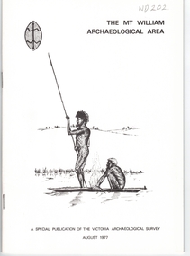
Document, Mt William Archaelogical Area, 1/08/1977 12:00:00 AM
Booklet issued by the Victorian Archaelogical Survey describing an abouiginal axe quarry at Mt William near Lancefield. The history of the site is described as is the archaelogical evidence.Booklet issued by the Victorian Archaelogical Survey describing an abouiginal axe quarry at Mt William near Lancefield. The history of the site is described as is the archaelogical evidence. A section describes the importance of axes in aboriginal culture. Map, illustrations.Booklet issued by the Victorian Archaelogical Survey describing an abouiginal axe quarry at Mt William near Lancefield. The history of the site is described as is the archaelogical evidence. aborigines, stone axes, mount william -
 Whitehorse Historical Society Inc.
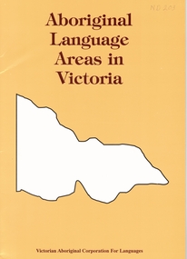
Document, Aboriginal language areas in Victoria, 1/07/1996 12:00:00 AM
Listing of all aboriginal languages spoken in Victoria.The distinction between language and dialect id discussed. Map, bibliagraphy.aborigines, aboriginal languages -
 Whitehorse Historical Society Inc.
Document - Hand Written Note, Blackburn Cool Store, 2001
Map drawn by Arthur Schwerkolt in 1993 from memory assisted by survey map of 1902.Manuscript account of the history and operation of the Blackburn Cool Store and the Blue Moon Fruit Cooperative, by Ron Pearce.Map drawn by Arthur Schwerkolt in 1993 from memory assisted by survey map of 1902.blackburn cool store, blue moon fruit co-operative ltd., southern victoria pear packing company limited -
 Whitehorse Historical Society Inc.
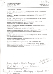
Letter - Correspondence, East Burwood Reserve, 1993
Various documents relating to the establishment of East Burwood ReserveVarious documents relating to the establishment of East Burwood Reserve including acquisition of land, details, plans, locality map, news cuttings and photographs. Appears to be copy of Nunawading City Council File April 1993Various documents relating to the establishment of East Burwood Reserve sportsgrounds, east burwood reserve, soilleur (dr), hitchens, anna, blue moon fruit co-operative ltd., jacobson and logan, king family, central methodist mission, aussat, tally ho, sewart, bill -
 Whitehorse Historical Society Inc.
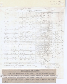
Document, The Village of Norwich, C1862
Map showing the planned village of NorwichMap showing the planned village of Norwich in Vermont about 1862Map showing the planned village of Norwichland settlement, morack road, vermont south, barkly street, vermont, george street, william street -
 Whitehorse Historical Society Inc.
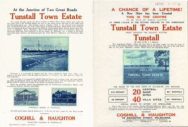
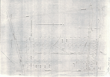
Legal record - Document, Tunstall Town Estate
Land subdivision at Tunstall 1926 bounded by Springvale Road, Whitehorse Road, Railway Parade.Land subdivision at Tunstall 1926 bounded by Springvale Road, Whitehorse Road, Railway Parade. Original in Haughton Maps LaTrobe LibraryLand subdivision at Tunstall 1926 bounded by Springvale Road, Whitehorse Road, Railway Parade. land subdivision, springvale road, nunawading, railway parade, kelly, j, nunawading state school, no. 4190, shire of blackburn and mitcham, whitehorse road, silver grove, glendale street -
 Whitehorse Historical Society Inc.
Document, Map of Vermont & Mitcham
... , Canterbury and Heatherdale roads. Map of Vermont & Mitcham Document ...Copy of map showing land in Mitcham and Vermont areasCopy of map showing land in Mitcham and Vermont areas bounded by Whitehorse , Mitcham, Canterbury and Heatherdale roads.Copy of map showing land in Mitcham and Vermont areasland subdivision, whitehorse road, mitcham, heatherdale road, canterbury road, vermont, mitcham road -
 Whitehorse Historical Society Inc.
Document - Leaflet, Blackburn Land Sale, 19/11/1910 12:00:00 AM
... and surrounding streets. Schedule of prices. Hand drawn map Blackburn Land ...Pamphlets showing sale of land Gardenia Street, Blackburn and surrounding streets.Pamphlets showing sale of land Gardenia Street, Blackburn and surrounding streets. Schedule of prices. Hand drawn mapPamphlets showing sale of land Gardenia Street, Blackburn and surrounding streets.blackburn township estate co. ltd., blackburn railway station, south parade blackburn, laburnum street, blackburn, the avenue blackburn, fuschia street blackburn, linum street blackburn, main street, t.r.b.morton. & son, land subdivision -
Whitehorse Historical Society Inc.
Document, Eastern Corridor Road Development, 1/11/1986 12:00:00 AM
Collection of maps showing Eastern Corridor Road Development and traffic volume for public display.Collection of maps showing Eastern Corridor Road Development and traffic volume for public display.Collection of maps showing Eastern Corridor Road Development and traffic volume for public display.freeways, ecord study team -
Whitehorse Historical Society Inc.
Document, Box Hill History Kit
Box Hill History Kit published by Box Hill Historical Society and Box Hill City Council.Box Hill History Kit published by Box Hill Historical Society and Box Hill City Council. Contents include Brochures, First Box Hill Railway Time Table, copies of Box Hill & Doncaster Tramway Tram and old photos taken around Box Hill, Tom Roberts Artists' Camp, 1905 Map of Box Hill etc.Box Hill History Kit published by Box Hill Historical Society and Box Hill City Council. box hill historical society, box hill city council -
 Whitehorse Historical Society Inc.
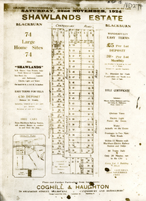
Document, Shawlands Estate, 22/11/1924 12:00:00 AM
Notice of Sale of land Holland Road and Canterbury RoadNotice of Sale of land Holland Road and Canterbury Road Blackburn Original in Haughton Maps LaTrobe LibraryNotice of Sale of land Holland Road and Canterbury Road land subdivision, canterbury road, blackburn south, holland road, shawlands avenue, coghill & haughton, shawlands estate, haughton map collection, state library of victoria. latrobe library -
Whitehorse Historical Society Inc.
Document, Andreas Fritsch, 1992
History and maps of the brick quarry opened by Andreas Fritsch in Nunawading in 1856.History and maps of the brick quarry opened by Andreas Fritsch in Nunawading in 1856. His quarry was between Burwood Road and Mahoneys Reserve, enclosed with a letter from Geoff Ford, historian and pottery collector to Mrs B. Gray. Information on history taken from Niall Brennan's 'History of Nunawading'.History and maps of the brick quarry opened by Andreas Fritsch in Nunawading in 1856. clay, fritsch, andreas, ford, geoff, gray, beryl, pottery -
 Whitehorse Historical Society Inc.
Document, Orcharding and the Blue moon Cooperative
Typescript history of the Blue Moon Cooperative LtdTypescript history of the Blue Moon Cooperative Ltd also a map indicating the destinations to which fresh fruit was shipped by the Blue Moon Group of companies.Typescript history of the Blue Moon Cooperative Ltdcool stores, blue moon fruit co-operative ltd -
Whitehorse Historical Society Inc.
Document, McGlone's Estate Mitcham, 1/04/1921 12:00:00 AM
Copy of pamphlet of McGlone's Estate, Mitcham auctioned April 1921.Copy of pamphlet of McGlone's Estate, Mitcham auctioned April 1921. 24 allotments. Bordered by Whitehorse Road, McGlone Street, Station Street and Mitcham railway line and station. Original in Haughton maps, LaTrobe Library.Copy of pamphlet of McGlone's Estate, Mitcham auctioned April 1921. land sales, auctions, mcglone, john, mcglone, elizabeth, whitehorse road, mitcham, mcglone street, mitcham, station street, mitcham, mitcham railway station, haughton map collection, state library of victoria. latrobe library -
 Whitehorse Historical Society Inc.
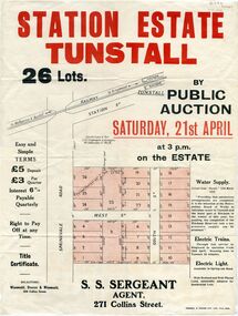
Pamphlet - Document, Station Estate Tunstall, 1923
Land Plan for auction of estate at Tunstall.Land Plan for auction of estate at Tunstall. Original in Haughton Maps, Latrobe LibraryLand Plan for auction of estate at Tunstall. auctions, station estate tunstall, s. s. sergeant (agent) -
Whitehorse Historical Society Inc.
Document, Australian Social History House Research Assignment, 1986
Social History of 2 Gordon Crescent, Blackburn,Social History of 2 Gordon Crescent, Blackburn, included - History of Blackburn, Architecture of the House and first owner, Thomas Richards Burrowes. Morton. Real Estate Brochures, Maps, Photos, Floor Plans.Social History of 2 Gordon Crescent, Blackburn, morton thomas richards burrowes, architecture -
 Whitehorse Historical Society Inc.
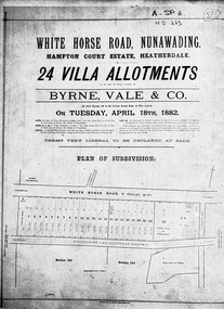
Document, Hampton Court Estate
Plan of subdivision Hampton Court EstatePlan of subdivision Hampton Court Estate Whitehorse Road, Nunawading 1882. Original in Vale Maps LaTrobe LibraryPlan of subdivision Hampton Court Estate hampton court estate, byrne vale & co. -
Whitehorse Historical Society Inc.
Document, Municipal Chambers, Nunawading, 23/07/2001 12:00:00 AM
Papers relating to applications for Council permits, objections and VCAT hearingsPapers relating to applications for Council permits, objections and VCAT hearings concerning development of 360-362 Whitehorse Road, Nunawading, and of 13 Walkers Road, Nunawading. Includes maps, plans, photos and architectural assessment of 360 Whitehorse Road by Andrew Ward.Papers relating to applications for Council permits, objections and VCAT hearings associated planning consultants, arrowsmith, valda, nunawading and district historical society, municipal chambers, whitehorse road, nunawading, no 360, no 362, walkers road, no. 13, victorian civil and administrative tribunal, ward, andrew, city of whitehorse