Showing 1371 items matching "east side"
-
 Rutherglen Historical Society
Image, 1900 Approximate
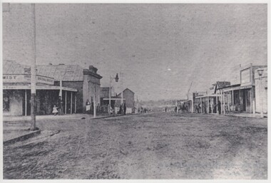
Donated by Mr Greg Thomson, a former resident of RutherglenBlack & white reproduction, unframed, laminated. This photograph is of Main St Rutherglen facing east. At the end of the right hand side in middle of photograph is a small white patch, this is the Chinese camp. Left hand corner is where Fire Station now stands, old Blue Bird Hall is next (now Goodfellows Supermarket)On back of photo: "Main St Rutherglen - facing east"main street, chinese camp, blue bird hall, goodfellows supermarket -
 Rutherglen Historical Society
Photograph - Image, 1970s
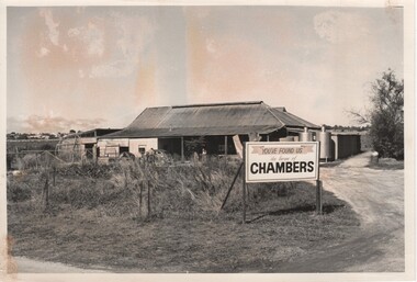
Established in 1858 by William Chambers and his son Phillip, the Chambers family have been making wine at Rosewood for over six generations. Black and white photograph of an iron roofed building with stainless steel tanks on one side, and sign in front.On sign in photo: "You've found us. The home of Chambers." On back of photo: "Chambers Rosewood" "78% p 27"wineries, north east victoria, wine industry, chambers winery, chambers rosewood, rutherglen winery, rutherglen australia, winemaker -
 Rutherglen Historical Society
Image, 1970s
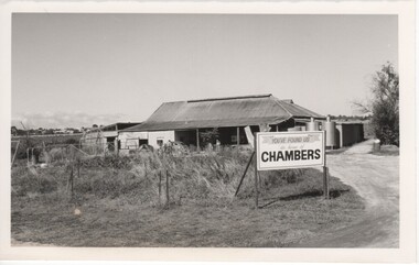
Established in 1858 by William Chambers and his son Phillip, the Chambers family have been making wine at Rosewood for over six generations.Black and white photograph of an iron roofed building with stainless steel tanks on one side, and sign in front.On sign in photo: "You've found us. The home of Chambers." On back of photo: "140% [upper case D in small circle] Chambers 'Rosewood' "wineries, north east victoria, wine industry, rosewood cellars, chambers winery, chambers rosewood, rutherglen winery, rutherglen australia, winemaker -
 Rutherglen Historical Society
Image, 1970s
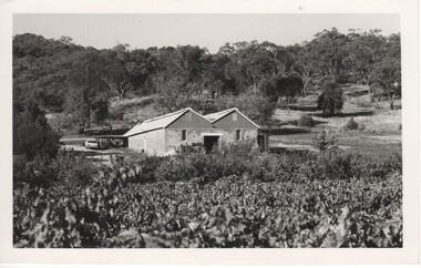
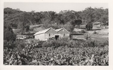
Our cellar, which was built from local stone by Esca in 1914, sits on the side of the Warby Ranges, overlooking the beautiful Taminick Valley and our estate vineyard.Black and white photograph with a view over a vineyard of a double roofed building. Hills with substantial tree cover in the background.On back of photo: "95% [lower case c in small circle] Booth Bros."wineries, north east victoria, wine industry, booth brothers winery, taminick, winemaking, glenrowan -
 Rutherglen Historical Society
Image, 1970s
Our cellar, which was built from local stone by Esca in 1914, sits on the side of the Warby Ranges, overlooking the beautiful Taminick Valley and our estate vineyard.Black and white photograph with a view over a vineyard of a double roofed building. Hills with substantial tree cover in the background.On back of photo: "Booths?"wineries, north east victoria, wine industry, booth brothers winery, wineries, north east victoria, wine industry, booth brothers winery, taminick, winemaking, glenrowan, taminick, winemaking, glenrowan -
 Rutherglen Historical Society
Photograph - Image, 1970s
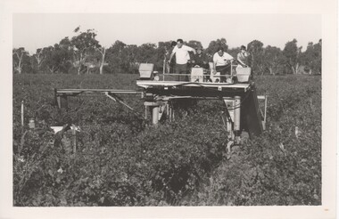
This is a photo of one of the first upright machine grape harvesters operating in the Rutherglen area. It was operating in the B Seppelt & sons Distillery Road vineyards on the edge of the Murray River in Wahgunyah. Riding on the top of the machine are from left to right Mandy Jones (partly obscured), Rolly Guscot (vineyard manager), machine driver, Doug Jones (manager) and Leanne Schoen (nee Jones). Mandy Jones and Leanne Schoen being the daughters of Doug JonesBlack and white photograph of several people riding on top of a machine operating in a vineyard. On left hand side is Leanne Jones , her father Doug Jones ( Manager of Seppelts) The photograph was taken in the flats vineyard ( now Pfeiffer vineyard) It was reputably the first mechanical grape harvester in the areaOn back of photo: "170% [upper case D in small circle] Seppelt's"wineries, north east victoria, wine industry, mechanical harvester, grape harvest, seppelts winery, rutherglen, doug jones -
 Ballarat Heritage Services
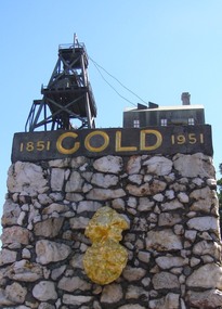
Photograph, Dorothy Wickham, Gold Monument, Ballarat, c2010
Gold was discovered in Ballarat in 1851 when many people rushed to the diggings. A monument commemorates the centenary of the finding of gold at Poverty Point and is dedicated to the memory of pioneer miners of Ballarat. It records gold yields, nuggets and the richest recorded yields of both alluvial and quartz mines. The replica gold nugget on the monument is the `Welcome Nugget`, found in Ballarat in 1858, weighed 2,217 ounces and was sold for £10,500. The memorial, known as the Pioneer Miners’ Monument, was made to commemorate Ballarat's gold centenary. It was proposed that part of the Pioneers' Memorial Fund might be used. This fund was started with £1300 profit from the 1938 centenary celebrations. (Age (Melbourne), The monument was created by John Edward Skilbeck, a toolmaker with Ronaldson and Tippett. John Skilbeck had a deep interest in Ballarat History, and undertook much research with Bert Strange and Keith Stacpoole. Councilllor William Ernest Roff provided the copper for the memorial from scrap copper obtained during his plumbing business. The copper was reworked by John Skilbeck, and was soldered in the kitchen of his home at 14 Frank Street. Colour photograph of the gold monument on the corner of Sturt Street and Albert Street, Ballarat. It commemorates the discovery of gold at Poverty Point in August 1851, and was The monument was unveiled in 1951 and is mainly constructed of large piecesof quartz, with a miniature popper head on the top made of copper. Mounted on the side is a replica of the Welcome Nugget, which was unearthed on the corner of Humffray and Mair Streets, Ballarat on 09 June 1858.FRONT This monument was erected by the Ballarat Historical Society to commemorate the finding of gold at Poverty Point 21st August 1851 and is dedicated to the memory of/ pioneer miners of Ballarat LEFT SIDE Richest recorded yields alluvial mines Band of Hope 303269 Ozs Prince of Wales 168929 Koh I Noor 164157 Great Redan Ex 110111 Albion 107125 Bonshaw Fr 96520 Park 94699 St George 86702 Sir Wm Don 76830 Hand in Hand 76830 Sir Henry Loch 43562 Quartz Mines Star of the East 256758 Ozs Band of Hope 158299 Victoria United 152013 N Woah Hawp 129562 New Normanby 127562 Britannia 103225 Llanberris No 1 100533 Black Hill 91665 Last Chance U 83766 Llanberris 71364 Speedwell 66000 South Star 64444 Sulieman Pasha Companies 62666 RIGHT Recorded gold yield 20606000 ozs Nuggets Alluvial Welcome 2217 ozs Saraha Snads 1619 Lady Hotham 1177 Canadian 1 1117 Canadian 2 1011 Koh 1 Noor 834 Eureka 625 Lady Loch 617 Prince of Wales 606 Bakery Hill 571 Native Youth 540 Faboulous yields of earliest diggings not offically recorded Quartz Nuggets N Woah Hawp 5-- 300 200 Ozs White Horse 500 Woah Hawp 444 266 262 Canton 257 200 Q Victoria lease 410 U Black Hill Coy 315 Tinworths 250 Parade Coy 245gold monument, ballarat, skilbeck, poppet head, j.e. skilbeck, john skilbeck -
 Whitehorse Historical Society Inc.
Photograph, Lowen Family, 19/11/2010 12:00:00 AM
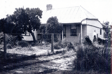
The Lowen family home at East Burwood, shown in about 1925, was removed and the property sold to allow Blackburn Road to continue through to meet up with Burwood Road. (Now Burwood Highway)Black and white photograph of a weatherboard house with a post and wire fence along the drive, and woman standing near the side of the houselowen family houses east burwood -
 Whitehorse Historical Society Inc.
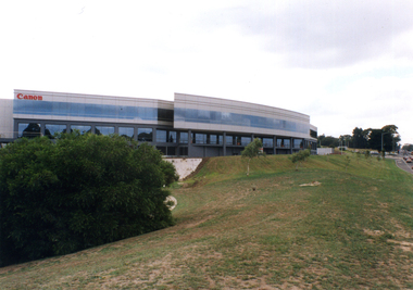
Photograph, Canon
The East Burwood Canon building is at 33 Lakeside Drive, Burwood East. Canon makes cameras, lenses, printers, scanners, video-cameras, photo copiers and so on.Three coloured photographs of the Canon office in Tally Ho Business Park, which is on the corner of Burwood Highway and Springvale Road. One photo shows the western side of the Canon building (with the pond), one shows the curved southern side, and one shows the building looking east from Springvale Road.tally ho business park, east burwood, canon pty ltd -
 Whitehorse Historical Society Inc.
Photograph, Mitcham Railway Station
Coloured photograph of cars in the car park on the south side of the Mitcham Railway Station. The view is looking east towards Mitcham Road - 2012mitcham railway station, parking, transport -
 Whitehorse Historical Society Inc.
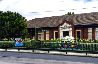
Photograph, Mitcham State School No 2904, 2012
See NP3945Coloured photograph of the Mitcham State School situated on the west side of Mitcham Road, opposite East Doncaster Road. Sign on the fence requesting 2012 prep enrolments.mitcham state school no 2904, state schools -
 Whitehorse Historical Society Inc.
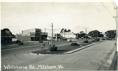
Postcard - Black and white postcard, Harold Millane, Whitehorse Road, Mitcham
Postcard: Black and white photograph of Whitehorse Road, Mitcham looking east from Station Street corner shops on eastern side and white heading 'Whitehorse Rd Mitcham, Vic.'Message written on reverse: see Media image.whitehorse road, mitcham, roads and streets, markham -
 Whitehorse Historical Society Inc.
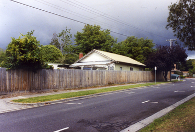
Photograph, Doncaster East Road, Mitcham, No.35, 2006
Coloured photo of south - west side of the Winchcombe family home on the corner of Doncaster East and Glen Roads, Mitcham in 2006 Mrs. Winchcombe, nee Ireland is related to the Ireland family who were orchardists and florist in Mitcham area in the early 1900s.winchcombe family, ireland family, doncaster east road, mitcham, no.35 -
 Whitehorse Historical Society Inc.
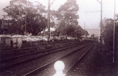
Photograph, Railway Track Looking East, 1/06/2009
One of a collection of photographs taken of the Nunawading Railway Station prior to the lowering of the railway line and building of the new railway station on the western side of Springvale Road so that the Springvale Road Rail Crossing can be eliminated.Black & white photograph of he precinct surrounding the Nunawading Station and the Springvale Road Railway crossing. This photograph is of the railway track looking east from railway crossing in Springvale road. Note the railway station in the distance. See NP 3545 to NP3567 for the complete set of photographsnunawading railway station, springvale road nunawading, redevelopment of railway line/springvale road. -
 Whitehorse Historical Society Inc.
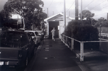
Photograph, Looking to Booking Office on North side of Nunawading Station, 1/06/2009
One of a collection of photographs taken of the Nunawading Railway Station prior to the lowering of the railway line and building of the new railway station on the western side of Springvale Road so that the Springvale Road Rail Crossing can be eliminated.Black & white photograph of he precinct surrounding the Nunawading Station and the Springvale Road Railway crossing. This photograph is the entrance to the Booking Office for trains from Nunawading travelling east. See NP 3545 to NP3567 for the complete set of photographsnunawading railway station, springvale road nunawading, redevelopment of railway line/springvale road. -
 Whitehorse Historical Society Inc.
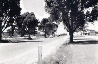
Photograph, Looking east to Mitcham, c1952
Sent to a parishioner at Christ Church, Mitcham, by Phyllis Grant who lived at the Migrant Hostel in Mitcham in 1952 -54, where her husband did development work under the P.M.G.Black and white photograph of Mitcham looking east from opposite Albert Street. Note the two lane road with trees each side of the road. Christ Church Mitcham in Edward Street can be seen on the left.whitehorse road, mitcham, christ church anglican church mitcham, grant, phyllis -
 Whitehorse Historical Society Inc.
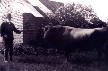
Photograph, Joseph Tainton with prize bull
... prize bull, 'Foxglove' on his property on the north side... prize bull, 'Foxglove' on his property on the north side ...Joseph Tainton emigrated to Australia in 1853 with his parents, James and Ann Tainton. He married Mary Jane Course and they had ten children. He was an orchardist.A photograph of Joseph Tainton taken c1926 holding his prize bull, 'Foxglove' on his property on the north side of Burwood Road, East Burwoodtainton, joseph -
 City of Ballarat Libraries
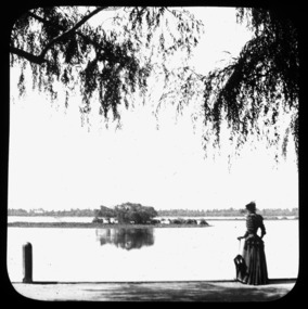
Glass Slide, Woman strolling at Lake Wendouree
The lady's clothes help us to date these images, circa early 1890s. She is standing at the steamer landing place; the first steam boat on the Lake was built in 1865 - from 1880 to 1910 the Lake was the social centre of the district, particularly on Sundays, when many people would arrive by steamer from the eastern shore. Previously unknown image of Ballarat. The set and its subjects indicate these images were produced to promote Ballarat and were perhaps aimed at tourists.Lake Wendouree, originally Yuille's Swamp, pictured from the western, or Gardens side. -
 City of Ballarat Libraries
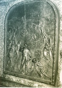
Photograph, Peter Lalor statue and reliefs
Peter Lalor statue and close up of bronze reliefs. Eureka Stockade relief on the south side and Lalor in Parliament on the north side of the statue. Located at the western end of the median strip where Dawson Street crosses Sturt Street.peter lalor, eureka stockade, statue, sturt street, dawson street, parliament -
 City of Ballarat Libraries
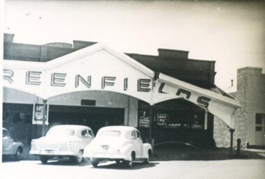
Photograph, Greenfields Doveton Street North, Ballarat circa 1950
Greenfields was a produce merchant located on the western side of Doveton Street North. It is unknown how the sign was damaged. greenfields, doveton street north, ballarat, commercial, building -
 City of Ballarat Libraries
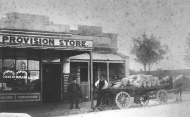
Photograph, Photos of the Anglin Family Grocery circa 1915
Anglin Grocery was located in Eureka Street, Ballarat East. The photos show both Albert Anglin Senior and Junior, the delivery wagon loaded with bags of chaff, a gig used for deliveries with Anglin Grocery painted on the side and an advertisement for Cadbury Chocolate on the shop window.anglin grocery, albert anglin, eureka street, ballarat east, ballarat, commerical, cadbury chocolate -
 City of Ballarat Libraries
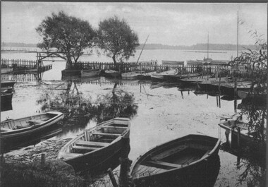
Photograph, Steamer Landing Wharf, Lake Wendouree circa 1930
Steamer landing wharf on the western side of Lake Wendouree.lake wendouree, steamer -
 City of Ballarat Libraries
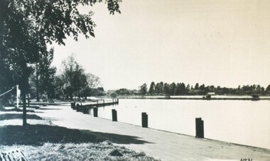
Photograph, Boat Harbour, Lake Wendouree circa 1890s
The boat harbour on Lake Wendouree was situated on the eastern side.lake wendouree, rowing, ballarat, harbour, entertainment -
 City of Ballarat Libraries
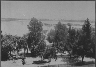
Photograph, View of Lake Wendouree from Fry's Mill circa 1890s
This view from Fry's Mill is of the eastern side of the lake.lake wendouree, fry's mill, ballarat -
 City of Ballarat Libraries
Photograph, Lake Wendouree & Paddle Steamer Shed circa 1890s
The Paddle Steamer Shed was located on the eastern side of Lake Wendouree.lake wendouree, paddle steamer, boat shed, building -
 City of Ballarat Libraries
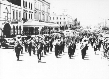
Photograph - Card Box Photographs, Marching Band, Ballarat c1940
This is possibly the Airforce Band marching along Armstrong Street North. The Stork Hotel can be seen on the left side of the picture.ballarat, marching band, entertainment, parade, stork hotel, building, commerical, public, armstrong street north -
 City of Ballarat Libraries
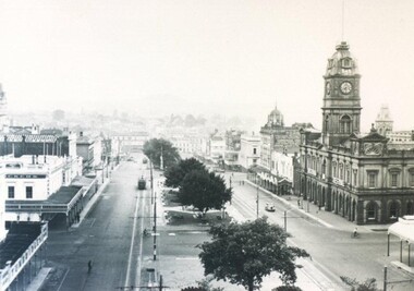
Photograph - Card Box Photographs, Ballarat Town Hall & Sturt Street circa 1936
You can see the Town Hall and both sides of Sturt Street looking east. Some of the business include Crockers and Tunbridges.ballarat town hall, sturt street, streetscape, electric tram, garden, crockers, tunbridges, vehicle, building, public building, commerical -
 City of Ballarat Libraries
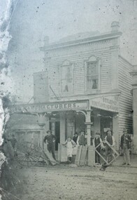
Photograph - Card Box Photographs, Wilkins & Williams General Store, Newlyn circa 1908
... Ballarat East goldfields Side view of the 2 storey store owned ...Side view of the 2 storey store owned by the Wilkins & Williams families from 1880-1940.wilkins & williams, general store, newlyn, building, commerical, private dwelling -
 City of Ballarat Libraries
Photograph - Card Box Photographs, Butler & Co Venetian Blind Maker, Ballarat circa 1900
The shop was located on the north side of Sturt and Errard Street. frank butler, manufacturing, building, work, people, commerical -
 City of Ballarat Libraries
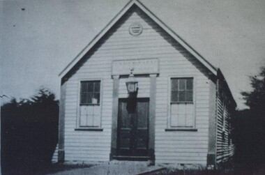
Photograph - Card Box Photographs, Baptist Tabernacle, Sebastopol circa 1925
The tabernacle was located on the west side of Albert Street between Vickers and Walker Streets. It was demolished in 1930.baptist tabernacle, church, building, albert street, sebastopol