Showing 872 items matching "halls gap"
-
 Halls Gap & Grampians Historical Society
Photograph - B/W
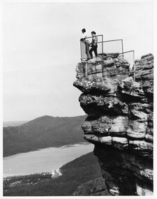
... Halls Gap & Grampians Historical Society Centennial Hall ...The two men are standing at The Pinnacle Lookout, overlooking Bellfield Reservoir in the Fyans ValleyTwo men standing behind cyclone wire three panel fence. Man on left is wearing a white shirt and long pants, the other in a checked shirt and long dark pants. They are on top of a large rocky outcrop overlooking a body of water and another mountain range scenery, lookouts -
 Halls Gap & Grampians Historical Society
Photograph - B/W
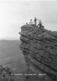
... Halls Gap & Grampians Historical Society Centennial Hall ...Photograph is taken at the Pinnacle in the Wonderland Range. The valley below is the Fyans Valley.Three men and a woman laying, sitting and standing on top of a high rocky outcrop. The woman and two men wear hats and the man standing is holding a stick. A mountain range can be seen opposite them with a valley far below, between the two ranges. A group of buildings can be seen in the valley. The style of dress worn by the people suggests early 1900s.The Pinnacle Wonderland Grampiansscenery, wonderland range -
 Halls Gap & Grampians Historical Society
Photograph - Photocopy
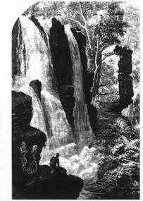
... Halls Gap & Grampians Historical Society Centennial Hall ...large waterfall. In the front foreground on the left are three people, two men and a woman. One man rests against the rocks. A woman stands beside him looking towards the waterfall whilst the third man is kneeling, looking over the edge of the ledge on which they are standing, down towards the falling water. On the right hand side many ferns are growingscenery, waterfalls -
 Halls Gap & Grampians Historical Society
Photograph - B/W
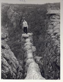
... Halls Gap & Grampians Historical Society Centennial Hall ...Photo is of the 'Nerve Test' and is a tourism promotion photo taken by the Victorian Railways. Photo shows woman standing at end of narrow ,rocky ledge. Large rock formations flank ledge on both sides. Woman is wearing black pants and a cardigan.scenery, wonderland range -
 Halls Gap & Grampians Historical Society... Halls Gap & Grampians Historical Society Centennial Hall ...
 -
Halls Gap & Grampians Historical Society... Halls Gap & Grampians Historical Society Centennial Hall ...
-
Halls Gap & Grampians Historical Society... Halls Gap & Grampians Historical Society Centennial Hall ...
-
Halls Gap & Grampians Historical Society... Halls Gap & Grampians Historical Society Centennial Hall ...
-
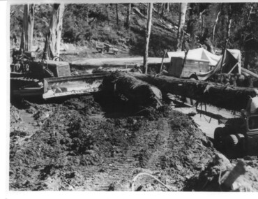 Kiewa Valley Historical Society
Photograph, logging at McKay Creek, Logging at McKay Creek, c1950's
This photograph was probably taken at the site of McKay Creek Power Station. Excavation of this site did not commence until 1951 but road access(a narrow track) was provided in 1948 and widened in 1954. The logs would have been milled for timber at the State Electricity Commission's mill at Howman's Gap and thus provided a much needed source of timber for construction of camps and houses as there was a general of shortage of this commodity. Because of trouble with landslides in this area, a decision was made to place the machine hall of the power station underground instead of on the surface. Restricted financial resources and the repositioning of the power station retarded construction activities and it was not completed until early 1961.. An excellent pictorial record of the general working conditions, type of machinery and vehicles in use in the 1950/s.Black and white photograph showing logging equipment, fallen logs.Handwritten on the back of the photograph "Logging at McKay Creek)logging, mckay creek, timber, machinery -
Port Melbourne Historical & Preservation Society
Photograph - Photograph -Centenary Bridge stairway, Port Melbourne, 1991
Taken by Alison Kelly during the demolition years for 'Bayside' developmentColour photograph of Centenary Bridge stairway (west, beach side) through the gap under the bridge can be seen what remains of the Port Melbourne railway shunting yard. Mounted on grey paper.centenary bridge, built environment - civic, transport, alison kelly -
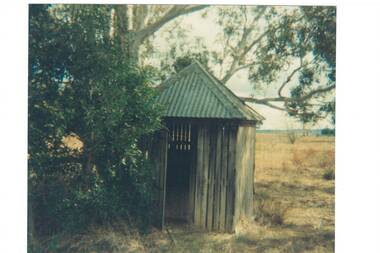 Buninyong & District Historical Society
Photograph - Original Photograph, Old toilet in Buninyong Cemetery, 1976
historic, buildingLost building, destroyed in a "burn-off."Colour photo, Old toilet in Buninyong Cemetery, Small shed, corrugated iron peaked roof, wooden slat walls with gaps, wooden door ajar, under a tree.toilet, shed, cemetery -
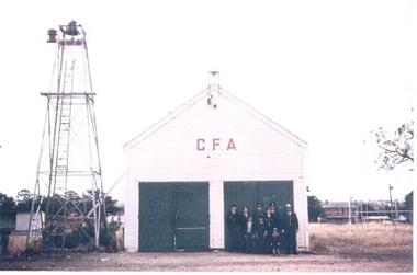 Hume City Civic Collection
Photograph, Early 1970s
The old Sunbury CFA station was situated in Evans Street where part of the Sunbury Shopping Square has been built. It was opened on that site in 1914. In 1969 a newer fire station was built in Evans Street on the opposite side of the road and closer to Macedon Street. From 1969 until 1978 the old fire station became a scout hall. In the early 2000s two new fire stations were built away from the main shopping area. One was built in Jackson Street, opposite the Ball Court Hotel and the other one was built on the corner of Gap Road and Elizabeth Drive. By locating them out of the immediate shopping centre which had become quite busy, it meant that access in and out of the new stations was quicker. The butter factory in Horne Street is on the RHS and the former public tennis courts are on the LHS of the photograph.A coloured photograph of the CFA firemen standing outside the former CFA building. The bell tower is on the LHS of the building.country fire authority, fire fighters, sunbury fire station, butter factory, tennis courts, george evans collection -
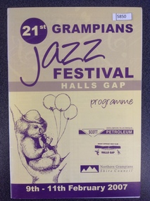 Stawell Historical Society Inc
Book, Hall Gap, 21st Grampians Jazz Festival, 2007
... Hall Gap... grampians stawell Program 21st Grampians Jazz Festival Book Hall Gap ...Programstawell -
Unions Ballarat
Deeper Leads: New Approaches to Victorian Goldfields History, Reeves, Keir, 2007
This book fills some gaps in the narrative of goldfields' history. The author addresses social and cultural significance of the goldfields' history.Relevant to the history of gold mining in Australia.Paper; book. Front cover: background is black and white. Picture of soil horizons.Front cover: title and editors' names.btlc, ballarat trades hall, ballarat trades and labour council, australian history, goldfields, gold, gold mining, social history, eureka stockade -
 Mt Dandenong & District Historical Society Inc.
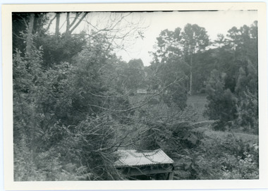
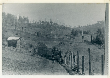
Photograph, View from George Barber's Home To His Stables
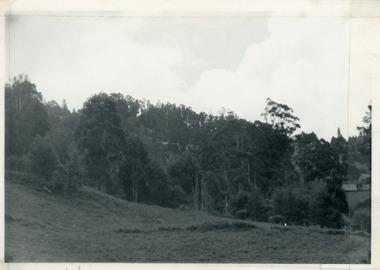
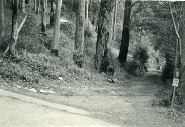
John Lundy-Clarke grew up in the Kalorama/Mt Dandenong area and later in life (1972-74) began to write a comprehensive history of the area working from an original settlement map in an effort to cover all areas. This photograph was taken by John Lundy-Clarke in 1973 to show changes to the environment sine 1905.Black and white photograph with tangled bush and small shed in foreground looking towards a cleared area. Handwritten description on reverse written by John Lundy-ClarkeView from Barbers drive to his stables close to where 1905 picture was taken. Stables in foreground. Looking towards Gap. Taken JLC November 1973.barbers road, john lundy-clarke, kalorama -
 Mt Dandenong & District Historical Society Inc.
Photograph, View of Kalorama Gap 1905
Kalorama Gap viewed from the South West in 1908. Ellis Jeeves' 'Mountjoy' is in the centre with the stables to the left. The raspberry patch belongs to Harry Walker and the building centre right to Edward Joseph Price. John Lundy-Clarke grew up in the Kalorama/Mt Dandenong area and later in life (1972-74) began to write a comprehensive history of the area working from an original settlement map in an effort to cover all areas.Black and white photograph showing an extensive raspberry crop in the foreground with a house and outbuilding in the centre and another dwelling centre right. Handwritten description on reverse by John Lundy-Clarke. 1908 view of Kalorama Gap taken from corner of Village Settlement LOTS 2 and 3 on Ridge (then Main Road) which crosses centre of picture with Walker’s driveway dropping left. Walker’s raspberry patch in foreground. “Mountjoy” in centre of picture with coaching stables on left. Price’s house and shop on right showing large cross room used by the Village Settlers for dancing. Mrs Hand’s “Beulah Tearooms” later Mt Dandenong North Post Office is above Price’s roof.kalorama gap, kalorama, harry walker, walker, edward joseph price, raspberry, mountjoy -
 Mt Dandenong & District Historical Society Inc.
Photograph, View Up Valley Towards Kalorama Gap 1973
John Lundy-Clarke grew up in the Kalorama/Mt Dandenong area and later in life (1972-74) began to write a comprehensive history of the area working from an original settlement map in an effort to cover all areas. This photograph would have been taken to show the changes in the area over the years. Kalorama Gap is now called Five Ways. 'Kia-Ora ' was a guest house built by George Barber. It is no longer standing.Black and white photograph showing a bush scene with a white car visible on the right. Handwritten inscription on reverse by John Lundy-Clarke1973 View up Valley towards Kalorama Gap from what was Crooks LOT 24. White car is on Barbers Road and site of “Kia Ora” is to right of it.kalorama, kalorama gap, five ways, barbers road, george barber, kia-ora -
 Mt Dandenong & District Historical Society Inc.
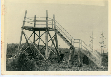
Photograph, Lookout On Top of Mount Olinda 1910, c1910
c1910 Lookout tower on the hill behind tthe school at Olinda.This shows the first one built. It was followed by a covered lookout. This position lost its value when the trees grew high. The descriptive text on the reverse of this photograph was hand written by John Lundy-Clarke.The lookout on the top of Mt Olinda 1910. This one was the first one it was followed by a covered one but the position lost its value with the growth of trees in the area. It is looking towards what is now Kalorama and the Jeeves clearing in the gap can be seen at the extreme left. lookout, tower, mt olinda, mount olinda -
 Mt Dandenong & District Historical Society Inc.
Photograph, View From George Barber's Home On Olinda Creek Towards The Gap. c1905, 1905
Black and white photograph showing view towards The Gap (Jeeves Saddle), (Five Ways) taken c1905. Detailed inscription on back handwritten by John Lundy-Clarke in 1973.1905 (c ) view from Barber’s home on Olinda Creek, towards the Gap, then known as Jeeves Saddle. Barber’s stable in foreground. “Shiloah” Complex centre right. Tait’s house in gully just left of centre. Logan’s house can just be seen under magnifier at top of same gully near line of Barber’s Road. “Kalorama” just below lowest portion of Gap skyline with Barnes (Paynters) house “Iona” to its left. Photo copied 1973. JLC. george barber, shiloah, kalorama, iona, olinda creek, the gap, jeeves saddle, tait, paynter, barber -
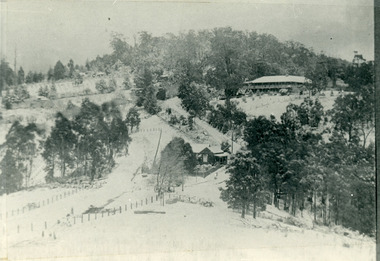
 Mt Dandenong & District Historical Society Inc.
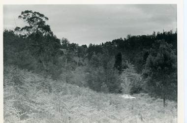
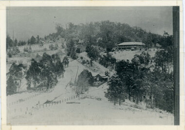
Photograph, Kalorama Gap Under Snow 1921, 1921
View of Kalorama Gap under snow taken in 1921. Mountjoy Guest House is at top right and Beulah Tea Rooms is in the centre. This photograph has a detailed inscription on the back handwritten by John Lundy-Clarke in 1974.Kalorama Gap under snow 1921 The leafless elm trees are low in the centre and the dual nature of the nearer one can be clearly seen, two small suckers of the older farther tree being twisted together in 1898 by Fred Jeeves. The older tree was planted 1880. Mrs Hands shop can be clearly seen, which was the Mount Dandenong North Post Office. The old Main Road runs up the centre of the picture and turns to the right and disappears behind “Mountjoy” the big guest house built by Paynters in 1905 and sold to Ellis Jeeves 1908, whose family ran it till 1943. At the bend of the road behind the big pine tree and the dark blackwood can be seen faintly the gable of Price’s house that contained the first shop on the mount. Above it is H Walker’s cottage on Ridge Road that still exists, his homestead is on the left of the picture on the same level. Below this house and to the left can be seen Ted Prices hay and corn store. The present estate agency lies between these two buildings, on the road which had recently been built. This can be seen winding from the lower left corner of picture to the left of the elms. The CRB had recently fenced the road and this is clearly seen as it circles behind trees in the left centre. Barber’s Road crosses CRB Road to the left of the dray under the leafless elm and the Coach Road dives down to the right just behind the pair of blackwoods to right of the elms. The picture was taken from just above the boundary of Isaac Jeeves’s selection Crown Allotment “C” (Jeeves Saddle) which stretched across the Gap to the other side of Mrs Hand’s shop, monopolising the gap from 1871 to 1879. Price’s house remains partly as the small house – “Mirra Laken”. kalorama gap, fiveways, post office, mountjoy, guest house, snow -
 Mt Dandenong & District Historical Society Inc.
Photograph, Post Office and 'Mountjoy', Mt. Dandenong North, 1913
Rose Series post card #182Copy of Rose Series postcard #182 showing Kalorama Gap in 1913. Haystacks in foreground with Mountjoy Guest House and Beulah Tea Rooms/Mt Dandenong North Post Office in centre. This photograph has a detailed inscription on the back handwritten by John Lundy-Clarke in 1974.Kalorama Gap in 1913 The elm trees are in the centre of the picture. One of these is really two as two suckers of the further tree were twisted together by Fred Jeeves in 1898 and grew as one tree. The other was planted in 1880. The shop is the shop of Mrs Eliza Hand and daughter Florence. The closed in far end of the verandah was the Mount Dandenong North Post Office. The large house is “Mountjoy” owned and run by the Jeeves Family from 1908 till 1943. It was built in 1905 by the Paynters who sold to Ellis Jeeves in 1908.He moved his line of coaches from “Kalorama” his old homestead and housed the horses in a line of stables behind “Mountjoy”. Price’s house, which contained their shop, the first one on the mountain, opened 1906, can be seen faintly behind the pine tree opposite the bend in the road, which was the main road then and now is Ridge Road. The Price’s house just shows in two tiny pieces, one on each side of the pine tree half way up. The house to the right of and high up the pine tree is Walker’s cottage which exists today opposite Jack Kidd’s home at the far edge of Lt 2 Village Settlement and was between Main Road and Barbers Road which runs down the left behind the elms. Walker’s homestead can be seen near left edge of picture 2/3 way up. The roof of the Methodist Church shows among trees left of picture. This, like Mrs Hand’s shop was built on portions separated from Isaac Jeeves’ Selection “C” known as Jeeves Saddle. kalorama gap, five ways, mountjoy, john lundy-clarke, beulah tea rooms, post office, fred jeeves, paynter, jeeves, frederick jeeves, price, walker, jack kidd -
 Mt Dandenong & District Historical Society Inc.
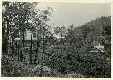
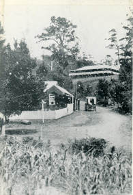
Photograph, 1908 View of Kalorama Gap From the Main Road, 1908
View of the Kalorama Gap from main Road (now Ridge Road), looking across Walker's raspberry patch with Mountjoy coaching stables on the LHS and Mountjoy Guest House in centre. Price's house and shop on the RHS.mountjoy, walker, raspberry, coach, stables -
 Mt Dandenong & District Historical Society Inc.
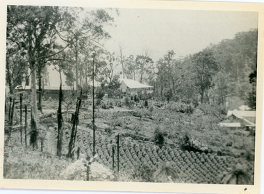
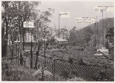
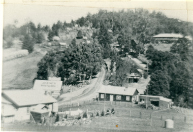
Photograph, 1908 View of the Kalorama Gap from Main Road With Labelling, 1908
Photograph with labels attached to front identifying buildings. View of the Kalorama Gap from main Road (now Ridge Road), looking across Walker's raspberry patch with Mountjoy coaching stables on the LHS and Mountjoy Guest House in centre. Price's house and shop on the RHS. This photograph has a detailed inscription on the back handwritten by John Lundy-Clarke in 1974.1908 View of the Kalorama Gap from main Road – now Ridge Road above Lot 2 of the Village Settlement. Looking across Walker’s raspberry patch with “Mountjoy” coaching stables on left. “Mountjoy” in centre. Prices house and shop on right with Hands “Beulah Tearooms” above Prices roof. On hillside beyond Hand’s is the slope now taken up by Kalorama Terrace. Walker’s well, then newly dug is in lower right hand corner below the tree fern head. Mt Kalorama is the hill top right. Track leaving Main Road left is Walker’s entrance drive.kalorama, kalorama gap, walker, beulah tea rooms, price, hand, mountjoy, mt kalorama -
 Mt Dandenong & District Historical Society Inc.
Photograph, View from 'Forest Edge', 1973
Photograph taken in 1973 from the property 'Forest Edge', the home of early settler George Barber. This photograph has a detailed inscription on the back handwritten by John Lundy-Clarke in 1973.Taken November 1973 by JLC. View looking from “Forest Edge” George Barber’s old home towards Price’s Lot 18. Gap on right skyline. Broadways house centre on Lot 18. Lot 25 in foreground recently cleared by Merchant Builders. Kia Ora site centre left. forest edge, george barber, price, kia ora -
 Mt Dandenong & District Historical Society Inc.
Photograph, Kalorama Gap in 1927, 1927
View of the Kalorama Gap (FiveWays) in 1927. Buildings shown are Jeeves' Garage, FiveWays Cafe, Nicholl's Store, Mountjoy. CRB Main Road, Ridge Road, Old Coach Road and barber's Road also visible. This photograph has a detailed inscription on the back handwritten by John Lundy-Clarke in 1974. The Kalorama Gap in 1927. Showing Jeeves Garage Fiveways Cafe Nicholls Store 'Mountjoy' C.R.B Main Rd Center Ridge Road Right of Center Old Coach Road lower right corner behind shed Barber's Road going left through clump of trees in center kalorama gap, kalorama, fiveways, fiveways cafe, jeeves, jeeves garage, garage, nicholls store, mountjoy, barbers road, old coach road, ridge road, main road, crb road -
 Mt Dandenong & District Historical Society Inc.
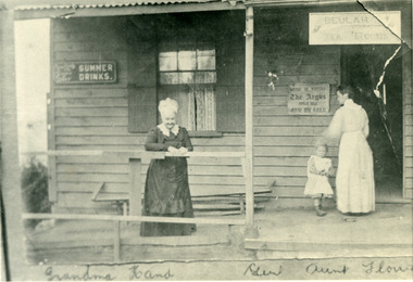
Photograph, Eliza Hand on the Verandah of her Shop 1907, 1907
1907 photoghraph of Eliza Hand (Grandma Hand), Florence Hand (Aunt Florrie) and little Gert on the verandah of the Beulah Tea Rooms at FiveWays (The Gap). This photograph has a detailed inscription on the back handwritten by John Lundy-Clarke in 1974.1907. Eliza Hand on the verandah of her shop at Kalorama gap with her daughter Florence. Opened as "Beulah Tearooms" it was made a post office in 1909 and Florence Hand became post mistress. It remained active till 1923 when, the building having been sold to Miss McPhee she built the Fiveways store alongside and moved the post office to another room. The verandah was pulled down but the room is still there (1974) facing Ridge Road at the west end of the complex. Eliza died 1918. Florence died 1968.beulah tea rooms, fiveways, the gap, florence hand, eliza hand, miss mcphee, post office -
 Mt Dandenong & District Historical Society Inc.
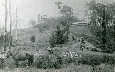
Photograph, The Busy Corner, 1907
View of Kalorama gap taken in 1907 showing Eliza Hand outside Beulah Tea Rooms, Briartys Coach, Dodd's Grocery cart and Meat Cutting cart. In foreground Fred Jeeves is standing and Theo Hand on hay. Mountjoy is in the background.This photograph has a detailed inscription on the back handwritten by John Lundy-Clarke in 1974.The Kalorama Gap in 1907. The coach road comes from right behind old stump. The shop was Hand's Beulah Tea Rooms soon to become the Mt Dandenong North Post Office. Big woman in black was Mrs Hand. wagon was Dodd's Grocery cart. "Mountjoy" on hilltop. The wagon with man was the first coach on the mount (Briartys). Small cart was Dodd's meat cutting cart. Horse at sledge was "Blossom" boy at her head was Fred Jeeves. Boy on sledge was Theo hand. Elm trees in centre of picture with Prices sign advertising shop and newsagency above them.mountjoy, beulah tea rooms, fred jeeves, theo hand, dodd's grocery cart, cart, coach, briartys -
 Mt Dandenong & District Historical Society Inc.
Photograph, The Gap Under Snow 1921, 1921
Snow scene looking up through The Gap (FiveWays) with Mountjoy Guest House on the hill to the right. The shop and post office are seen in the centre of the picture. This photograph has a detailed inscription on the back handwritten by John Lundy-Clarke in 1974.The Gap under snow 1921. “Mountjoy” on hill. New CRB road formation (unmetalled) comes into picture lower left corner, passes left of dray under the elms, then circles around behind the trees behind Miss Hands shop and home and Post Office (Mt Dandenong North) to pass out of picture left in centre of picture. It passes between Ted Prices Hay & Corn store and Walker’s house where the Estate Agency was later placed. Main Road then in centre of picture bend right behind Mountjoy. Price’s house and shop behind the blackwood left of road bend. CRB cuts across Barbers left of Elm trees.john lundy-clarke, kalorama, mountjoy, mountjoy, the gap, post office, mt dandenong north, snow -
 Mt Dandenong & District Historical Society Inc.
Photograph, The Wagon Road, c1970s
The old Wagon Road built 1876-1878. This photograph has a detailed inscription on the back handwritten by John Lundy-Clarke in 1974.The Wagon Road. Built 1876 – 8. The first settler’s road in the Ranges as apart from Dray Tracks. Was built through Jeeves Selection, Crown Allotment “C” named “Jeeves saddle” and removed the monopoly held over travel through the Gap. jeeves saddle, kalorama, road, wagon road, john lundy-clarke -
 Mt Dandenong & District Historical Society Inc.
Photograph, The Gap at Kalorama 1913, 1913
1913 scene looking up to Mountjoy Guest House at the Kalorama Gap (FiveWays). Post Office and tea rooms with white picket fence. Jeeves Coach on the road. This photograph has a detailed inscription on the back handwritten by John Lundy-Clarke in 1974. The Gap Kalorama 1913. ‘Mountjoy’ guest house. Mount Dandenong North Post Office. Jeeves coach.fiveways, mountjoy, post office, mt dandenong north, the gap, jeeves, coach