Showing 126301 items
matching main-road
-
 Eltham District Historical Society Inc
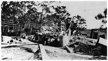
Negative - Photograph, Construction of the new concrete bridge over the Diamond Creek on Main Road, Eltham, c.May 1926
Construction of the new concrete bridge over the Diamond Creek on Main Road, Eltham, c.May 1926. Viewed from northern approach looking south east towards Eltham Park (Eltham Lower Park), showing the power lines that used to run in front of the park. The original long suspension bridge over the Diamond Creek on Main Road at Eltham collapsed during flooding of the Diamond Creek on October 13 and 14, 1923. The original bridge was built around 1840 for the coach road when Cobb & Co.'s coach was the only conveyance between Eltham and Melbourne. Widespread damage was done in Melbourne and surrounding areas by floods resulting from the overflow of the Yarra at many points along its banks. A temporary bridge rigged up was severely damaged by the flooding of the creek and was closed to vehicular traffic in April 1924. A new concrete bridge was constructed to replace it and by May 1926 all the concrete piles and abutments had been completed. The bridge was finally completed and opened for traffic in September 1926, almost three years after it initially collapsed.This photo forms part of a collection of photographs gathered by the Shire of Eltham for their centenary project book,"Pioneers and Painters: 100 years of the Shire of Eltham" by Alan Marshall (1971). The collection of over 500 images is held in partnership between Eltham District Historical Society and Yarra Plenty Regional Library (Eltham Library) and is now formally known as the 'The Shire of Eltham Pioneers Photograph Collection.' It is significant in being the first community sourced collection representing the places and people of the Shire's first one hundred years.Digital image 4 x 5 inch B&W Negshire of eltham pioneers photograph collection, bridge, bridge construction, cement mixer, diamond creek (creek), eltham, eltham lower park, eltham south, main road bridge -
 Tatura Irrigation & Wartime Camps Museum
Photograph, Goulburn Waranga Main Channel Construction, 1957
Photo taken by the photographer for Victoria State Rivers and Water Supply Commission of the Goulburn Waranga main channel in 1957.Large black and white photograph - dry mounted to cream board. Channel excavation scene - with excavator operating in mid distance, tractor with rooter in foreground.Below photo: "Goulburn Waranga Main Channel Construction / Channel excavation in progress / 200 W. Bucyrus Dragline, D.8 Caterpillar Tractor with rooter with "Gradall"goulburn, waranga, irrigation, photo, victoria state rivers and water supply commission -
 Glen Eira Historical Society
Album - Album page, Orrong Road, Circa 1972
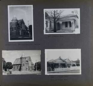
This photograph is part of the Caulfield Historical Album 1972. This album was created in approximately 1972 as part of a project by the Caulfield Historical Society to assist in identifying buildings worthy of preservation. The album is related to a Survey the Caulfield Historical Society developed in collaboration with the National Trust of Australia (Victoria) and Caulfield City Council to identify historic buildings within the City of Caulfield that warranted the protection of a National Trust Classification. Principal photographer thought to be Trevor Hart, member of Caulfield Historical Society. Most photographs were taken between 1966-1972 with a small number of photographs being older and from unknown sources. All photographs are black and white except where stated, with 386 photographs over 198 pages. Victorian Heritage Database H0704 FORMER UNION CHURCH 84-86 ORRONG ROAD ELSTERNWICK https://vhd.heritagecouncil.vic.gov.au/places/428 The Former Union Church, Elsternwick, designed by the architect George de Lacy Evans, and erected in 1889-90 is a building of historical and architectural significance for the following reasons:- (1) it is a rare and well- developed example of the early French Gothic manner as popularised through the muscular Victorian re-interpretation of English architect William Burgess, which in turn were derived from the publications of EE Viollet-le-Duc. Other Victorian cases of detailing derived from Viollet-le-Duc include Barwon Park (1868), the Presbyterian Church at Skipton (1871), the Bourke Street West Police Station by Bindley and Brittingham (PWD) dating from 1888-9 and the Lutheran Manse, East Melbourne by JAB Koch (1890). However, none of these buildings relates closely in form to the Union Church, Elsternwick. The only building which has been identified as closely comparable is The Bairnsdale Court House by AJ Macdonald (PWD) which dates from 1892. (2) the use of bright red brickwork is of significance, as the Former Union Church is believed to be only the second church building in Victoria to employ this material as a matter of conscious choice. Amongst red brick churches, it is thought to be preceded only by Reed, Henderson And Smart's Sacred Heart (1884), a Renaissance inspired design. (3) the building is believed to be a rare, possibly unique, surviving example of a church building erected for dual use by the Congregationalists and Baptists. In 1894 it was bought by the Congregationalists and continued as a Congregational Church until the formation of the Uniting Church.Page 165 of Photograph Album with four photographs, two of a church with the other two of houses on Orrong Road.Handwritten: ELSTERNWICK CONGREGATIONAL CHURCH [under top left photo] / 82 ORRONG ROAD [under top right photo] / 663-1 ORRONG ROAD / SEMI - DETACHED PAIR / 165 [bottom left]trevor hart, elsternwick congregational church, king street, orrong road, church, elsternwick, red brick, former union church, early french gothic style, architects, george de lacy evans, baptist church, conical towers, houses -
 Eltham District Historical Society Inc
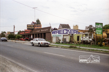
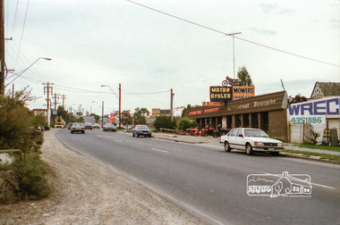
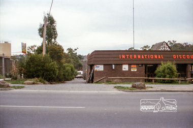
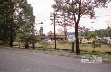
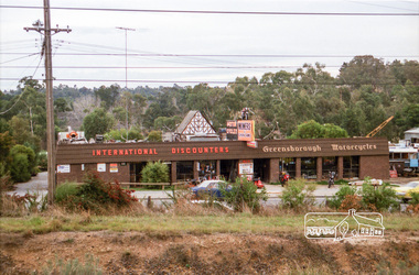
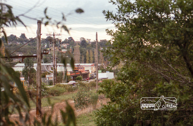
Photograph, Industrial development, Para Road, Briar Hill, c.1984, 1996
Views of industrial sites and shop fronts on Para Road, Briar Hill including the business 'Greensborough Motorcycles'. Para Road, Briar Hill is parallel to the Hurstbridge Railway Line. The building 'Greensborough Motorcycles' was destroyed by fire in the early 2000s.Roll of 35mm colour negative film, 4 stripsKodak CP 100 5094briar hill, greensborough, greensborough motorcycles, hutchinson's, industry, international discounters, para road -
 Eltham District Historical Society Inc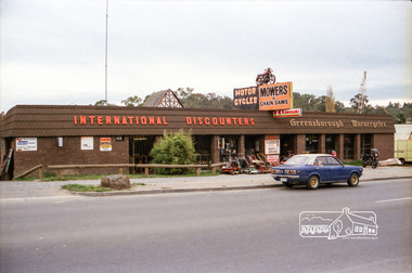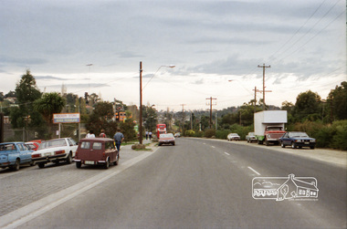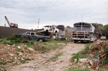
Negative - Photograph, Industrial development, Para Road, Briar Hill, c.1984
Views of industrial sites and shop fronts on Para Road, Briar Hill including the business 'Greensborough Motorcycles'. Para Road, Briar Hill is parallel to the Hurstbridge Railway Line. The building 'Greensborough Motorcycles' was destroyed by fire in the early 2000s.Roll of 35mm colour negative film, 4 stripsKodak CP 100 5094briar hill, greensborough, greensborough motorcycles, hutchinson's, industry, international discounters, para road, business -
 Eltham District Historical Society Inc
Photograph, Industrial development, Para Road, Briar Hill, c.1984, 1996
Views of industrial sites and shop fronts on Para Road, Briar Hill including the business 'Greensborough Motorcycles'. Para Road, Briar Hill is parallel to the Hurstbridge Railway Line. The building 'Greensborough Motorcycles' was destroyed by fire in the early 2000s.Roll of 35mm colour negative film, 4 stripsKodak CP 100 5094briar hill, greensborough, greensborough motorcycles, hutchinson's, industry, international discounters, para road -
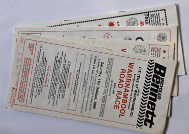 Warrnambool and District Historical Society Inc.
Programme - Four Programmes of Melbourne to Warrnambool Men's Cycle Race, Warrnambool Citizens' Road Race Committee, Warrnambool Road Race, 1980s
Melbourne to Warrnambool Men's Cycle Race programmes.1 One sheet of paper folded into eight pages with printed red and black text and advertisements. .2 Twelve pages containing red and black printed text and advertisements. Loose sheet containing handwritten comments. .3 Twelve pages containing red and black printed text and advertisements. .4 Eight pages containing red and black printed text and advertisements.non-fictionMelbourne to Warrnambool Men's Cycle Race programmesmelbourne to warrnambool men's cycle race, warrnambool sporting events -
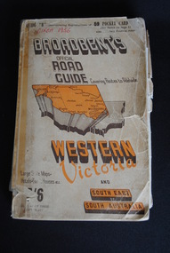 Anglesea and District Historical Society
Road Directory, Broadbent's Official Road Guides Company, Broadbent's Official Road Guide Western Victoria, 1956
Contains maps and advertisements for Western Victoria in 1956 as well as some of South-East of South Australia. 240 pages. Fold out maps included.Circa 1956maps, advertisements, broadbent -
Healesville Sanctuary Heritage Centre
Newspaper, Mobil Road Guide, Mobil Road Guide to the Sir Colin MacKenzie Sanctuary Healesville, 1950
Map and description of some animals in Sanctuary.Photocopynon-fictionMap and description of some animals in Sanctuary.1950s -
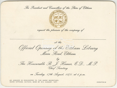 Eltham District Historical Society Inc
Invitation, The President and Councillors of the Shire of Eltham request the pleasure of the company of __ to the Official opening of the Eltham Library, Main Road, Eltham by The Honourable R.J. Hamer, E.D., M.P. Chief Secretary on Tuesday, 17th August, 1971, at 6 p.m, 1971
The Eltham Library was located at the southern end of the newly constructed southern wing of the Shire Offices at 895 Main Road. The first dedicated library in the shire was the Children's Library built by the Eltham War Memorial Trust (now the Eltham War Memorial Hall). Funds were raised by volunteers to purchase books, the land and construct the building. This library initially opened in the Eltham Public Hall on the corner of Main Road and Arthur Street around 1948. The Children’s Library building was opened in 1961 but the transfer to the Eltham Council of the War Memorial Trust land and buildings in 1965 saw the closure of the children's library, which held over 2,000 books that were then transferred to all the schools in the shire which had participated in the monthly book exchange of boxes of books by use of the railways, bus companies and private cars. In late 1966 the children’s library service was integrated into the Heideberg Regional Library Service and the building was officially renamed the Eltham War Memorial Hall. The Brinkkotter house in Dudley Street became the first of the general library services in Eltham with shelving from the old Heidelberg City Library, staff borrowed form the Heidelberg Library and some use of the 1941 Shire Office in Main Road. By 1971 the 1964 Shire Office had the southern extension added and the Library was located on the lower level with Engineering and Planning on the level above. By 1986 this library was experiencing overcrowding from lack of space and equipment needs. With Federal Government assistance, Council was able to design and build a new library which was located in the Eltham Common and opened in May 1994.Background workings for the funding of a Public Hall at Eltham. The funding was provided by public subscription and the money loaned to Council to build the hall. The hall was part of the new Eltham Shire offices located at the corner of Main Road and Arthur Street. A similar funding approach was used a few years later to provide for the Eltham War Memorial located on the opposite side of Main Road.Printed card 10.5 x 15.7 cmeltham library, eltham library opening, eltham shire council, opening ceremony, r.j. hamer, shire of eltham -
 Eltham District Historical Society Inc
Negative - Photograph, Burgoyne family outside J.N. Burgoyne's Store, Main Road, Eltham, Vic, 1940
The store built in 1925 was located on Main Road just south of Bridge Street (present day No. 820 Main Road). An extension was added to the right in 1939. The store was built in late 1925 at the same time as Mr C. Nicholls’s new store was constructed. Both were considered modern shops, and an improvement on most, business establishments of the time. Mr. Nicholls’s store included alongside it a modern, weatherboard villa residence. Mr. Burgoyne’s store incorporated the post and telegraph office, which was operated by John Neville Burgoyne’s half-aunt, Miss Anne Hunniford until her death in 1928 at which time J.N. Burgoyne became postmaster. The unsealed footpath in front is reasonably extensive as not visible is a concrete kerb and channel which was laid from the Post Office to John Street during Nov-Dec 1926. Footpath construction in front of Burgoyne’s store commenced August 1942. The extension to the right of the store was erected in 1939 for a new telephone exchange adjacent to the store and post office. A continuous telephone service operated by Mr Burgoyne and his family commenced operation 18 November 1939. Approximately 70 extensions were routed through the new exchange, 40 of which were transferred from the Greensborough Exchange. Entry to the exchange was via a separate door on Main Road or via the shop. The public telephone was initially mounted on the wall but later moved to the street. Cross Ref: 0701 of the store c.1934This photo forms part of a collection of photographs gathered by the Shire of Eltham for their centenary project book,"Pioneers and Painters: 100 years of the Shire of Eltham" by Alan Marshall (1971). The collection of over 500 images is held in partnership between Eltham District Historical Society and Yarra Plenty Regional Library (Eltham Library) and is now formally known as the 'The Shire of Eltham Pioneers Photograph Collection.' It is significant in being the first community sourced collection representing the places and people of the Shire's first one hundred years.Digital image 4 x 5 inch B&W Negshire of eltham pioneers photograph collection, burgoyne's shop, eltham, main road, post office, shops -
 Eltham District Historical Society Inc
Negative - Photograph, Tom Prior, Main Road near Eltham Railway Station, c.1910
View looking south along Main Road, Eltham from near present day Luck Street. On the immediate right is a fence with the words “Hot Water” painted on it followed by William J Capewell’s butcher shop, then the slaughter yard and saleyards with the entrance access to the railway station. Contained within the saleyards facing the street, a small shelter with the name H.H. Clark upon it. Horace Harold Clark was the son of Eltham State School’s first Head Teacher, David George Clark. As well as being a farmer, he was an Estate Agent and conducted auction sales, presumably from this shelter. The large weatherboard building on the corner (opposite present-day Arthur Street) with signs for Summer Drinks and Hot Water painted on the side is Luther and Ada Haley’s General Store and Bakery, built 1902. This was the first building in what is now Eltham’s present shopping town centre. Haley previously ran the General Store and Bakery on the corner of Main Road and York Street until his lease expired and the premises were bought by Mrs Sarah Burgoyne in 1902. The store later was known as Staff's Store. In the distance approximately mid-way between the Butcher shop and the Bakery are the tops of what appears to be two cypress trees, which could well be the trees in front of the Shillinglaw Cottage facing Main Road. On the eastern (left) side of Main Street is Haley’s Paddock, which was used on occasions for community picnics. Capable of holding 10,000 people, with ample shade and hilly surroundings it was an ideal place for any community gathering such as the State Schools’ Picnic in 1904. Picture dated as c.1910 based on similar picture published in the Weekly Times, Feb. 1912. Kerb and channelling added 1923. Cross Ref: 610 (looking north), 611 (later stage), 613. Same as 705 (though in better condition)This photo forms part of a collection of photographs gathered by the Shire of Eltham for their centenary project book,"Pioneers and Painters: 100 years of the Shire of Eltham" by Alan Marshall (1971). The collection of over 500 images is held in partnership between Eltham District Historical Society and Yarra Plenty Regional Library (Eltham Library) and is now formally known as the 'The Shire of Eltham Pioneers Photograph Collection.' It is significant in being the first community sourced collection representing the places and people of the Shire's first one hundred years.Digital image 4 x 5 inch B&W Neg 120 format B&W negative (spare)shire of eltham pioneers photograph collection, eltham, main road, butcher, eltham railway station, railway station, w.j. capewell, baker, eltham town centre, general store, luther haley, reynolds prior collection, shops, haley's paddock, hot water, m.m. clark, sign, summer drinks, eltham sale yards, eltham slaughter yard, staffs general store -
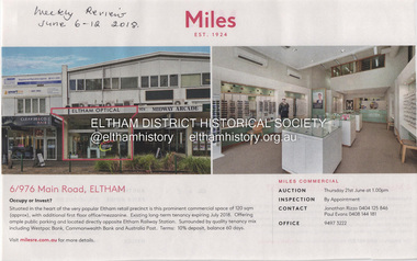 Eltham District Historical Society Inc
Document - Property Binder, 976 Main Road, Eltham
Newspaper advertisement: Diamond Valley Leader, 2 April 2008, Midway Arcade complex. Newspaper advertisement: Weekly Review, 6-12 June 2018, Miles real estate, 6/976 Main Road Eltham. Newspaper advertising feature: The Age, 22 December 2020, Traditional Italian goodness to cool off in summer, When gelato 'gluttony' comes in 36 flavours.main road, eltham, property, houses, shops, businesses, midway arcade eltham, eltham optical, miles real estate, augustus gelatery, paul vernuccio, joe molinaro -
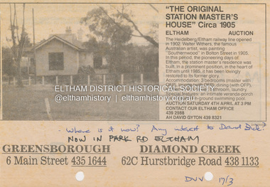 Eltham District Historical Society Inc
Document - Property Binder, 58 Park Road, Eltham (previously 967 Main Road, Eltham), 17 Mar 1992
The Original Station Master's House, Circa 1905, Eltham Auction; Diamond Valley News, March 17, 1992 The advertisement states the house is circa 1905 which is approximately correct. When the railway first came to Eltham in 1902 there was no appointed Stationmaster. The Guard on the train was the general oddsbody who did everything including sell tickets and station master duties. There was some discontent about this situation. It was probaly a few years before a permanent stationmaster was appointed but no reference to that has yet come to light. The house form photos dated in 1983 certainly had the appearance of an Edwardian style (1901-1910). The advertisement also states the house was in the centre of Eltham till 1985 before it was shifted from its original site to 58 Park Road.. The auction date is scheduled for Saturday April 4th - which would have been 1992. Essentially the house was sold in 1986 for $1 to save it from demolition and was then relocated to 58 Park Road. A Bill McGilvray was Stationmaster and lived in the house in the 1960s. A check of the 1968 Electoral Roll (via Ancestry) shows William John McGillivray, Station Master at the Station Residence, Eltham. Also at the same address in 1968, Marjorie Jean McGillivray, home duties, Station Residence, Eltham and Dianne Marjorie McGillivray, teacher, Main Road, Eltham. From the available records digitised, William first appears at the Station Residence in 1963. William and family were still in the residence in 1977 but by 1980 William, still Station Master, was living in Bible Street, so not sure who was in residence if anyone between 1980-1986. A property report shows the site at 58 Park Road was sold in 1983 and the relocated house on the site was then sold in 1992, then 2000 and most recently in April 2022. 58 park road, 967 main road, auction, auction sale, businesses, eltham, eltham railway station, houses, main road, park road, property, real estate advertisement, station masters house, station master's house eltham -
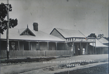
 Ballarat Heritage Services
Photograph - Black and White, Savoia House and Spring Creek Hotel
Now known as the Savoia Hotel, the original Savoia House is still present behind a new brick front. Black and white photograph of Savoia House and Spring Creek Hotel, Main Road, Hepburn Springs. savoia house, savoia hotel, spring creek hotel, k.c.b. mclaoughlin, hotels, hepburn springs -
 Ballarat Heritage Services
Photograph - Photograph - Black and White, Savoia House and Spring Creek Hotel
Now known as the Savoia Hotel, the original Savoia House is still present behind a new brick front in Hepburn Springs Black and white photograph of Savoia House and Spring Creek Hotel, Main Road, Hepburn Springs. Savoia House K.C.B. Keeps Cool Beer McLoughlin's Spring Creek Hotel. Savoia House and Spring Creek Hotel, Hepburnsavoia house, savoia hotel, spring creek hotel, hotels, hepburn springs, mclaughlin -
 Kew Historical Society Inc
Photograph, Stuart Tompkins Studio, Electricity Supply Poles, Burke Road, Kew, 1965
Research provided by Stuart Tompkins Studio, Box Hill, into alternatives for median strip street lighting to be used in Burke Road, Kew. The photographers identified variants in different suburbs appropriate to Kew's needs.The series from which the photograph is drawn provides a snapshot by a commercial photographic studio of each named vicinity in 1965 as well as providing examples of public works infrastructure being commissioned by local government in the 1960s. The photos originally formed part of the Engineering Department's files in the City of Kew before being donated to the kew Historical Society.Electricity Supply Poles, Burke Road, Kew, 1965. This photograph of Burke Road, Kew was taken just north of Kilby and Doncaster Roads looking north. Stuart Tompkins Studio provided the photograph for the Kew City Council. In the photograph are a number of electricity supply poles that have been erected in the median strip, in addition to some new poles on each footpath. The nearest wooden pole is stated to be 13.5″ in diameter. The electricity poles in Burke Road required Kew Council to investigate comparable designs in other Melbourne municipalities. [There are three copies of this photograph in the Collection.] Typed inscription on reverse: "Electricity Supply Poles. Photographed for Kew City Council 8/2/65. No.5 Burke Road - Kew, just north of Kilby and Doncaster Roads looking north. Some of seven poles already erected in median strip. Shows also some new poles erected on each footpath. Nearest wooden pole 13 1/2" dia." Studio stamp: "Stuart Tompkins Studio. 547 Station Street, Box Hill. WX1439."stuart tompkins studio, street lighting, south road (moorabin) 1965 -
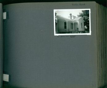 Glen Eira Historical Society
Album - Album page, Bealiba Road, Circa 1972
This photograph is part of the Caulfield Historical Album 1972. This album was created in approximately 1972 as part of a project by the Caulfield Historical Society to assist in identifying buildings worthy of preservation. The album is related to a Survey the Caulfield Historical Society developed in collaboration with the National Trust of Australia (Victoria) and Caulfield City Council to identify historic buildings within the City of Caulfield that warranted the protection of a National Trust Classification. Principal photographer thought to be Trevor Hart, member of Caulfield Historical Society. Most photographs were taken between 1966-1972 with a small number of photographs being older and from unknown sources. All photographs are black and white except where stated, with 386 photographs over 198 pages.Page 38 of Photograph Album with one landscape photograph of a timber house at 87 Bealiba Road.Handwritten: Bealiba Road [top right hand corner] / 87 Bealiba Road [underneath photograph] / 38 [bottom right]trevor hart, caulfield south, bealiba road, verandah, edwardian, woodworking, towers, chimneys, weatherboard houses -
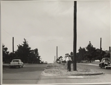
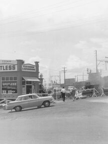 Ringwood and District Historical Society
Photograph, Maroondah Highway East, Ringwood- 1964. Water main repair work on the north-east corner of Maroondah Hwy and Warrandyte Road
Black and white photographWritten on back of photograph: "New water main, corner Warrandyte Rd. and Maroondah Highway. 1964." Building on corner occupied by 'Spotless Cleaners & Launderers'. -
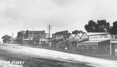 Ringwood and District Historical Society
Photograph, Maroondah Highway Central, Ringwood. Main Street looking west from Warrandyte Road- c1920
Black and white photograph (3 copies- 2 large, 1 small postcard)Written on back of photograph: "Main St Ringwood, c1920. Taken at the corner of Warrandyte Rd, looking west." All buildings in centre demolished for Eastland. -
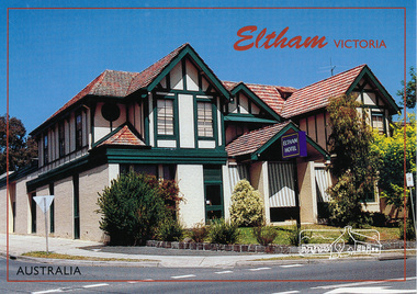 Eltham District Historical Society Inc
Postcard, McKenzie Photography, Eltham Hotel, Eltham, Victoria, Australia, 2015c
... main-road ...Postcard of Eltham Hotel, cnr Main Road and Pitt Street viewed from Main Road looking towards Pitt Street. Mel: 21 J7eltham-hotel, main-road, pitt-street, eltham -
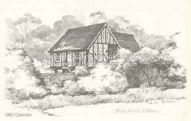 Eltham District Historical Society Inc
Calendar, Bill Caldwell, Sketch (reprint): Main Road, Eltham, Bill Caldwell n.d, c.1981
One of a series of sketches commissioned by Neville Emerson of Neville Emerson Real Estate, originally for use as christmas cards. EDHS does not hold a Christmas card of this image which was also used on the Wiregrass Gallery calendar for 1982. Whilst titled Main Road, Eltham, the house featured is that of Matcham Skipper which is raised on stilits due to the propensity of the Diamond Creek to flood. The actual address for the house is Dalton Street.Illustration from 1982 calendarart, artist, bill caldwell, fay bridge collection, neville emerson real estate, sketches, wiregrass gallery calendar, matcham skipper, dalton street