Showing 2734 items
matching maps of goldfields
-
 Federation University Historical Collection
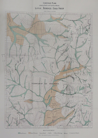
Map - Report, H.S. Whitelaw, Report on the Little Bendigo or Nerrina Gold-Field, Ballarat, 1901, 1901
Blue soft covered book. Includes Contour plan of the Little Bendigo Goldfieldlittle bendigo, nerrena, nerrina, h.s. whitelaw -
 Federation University Historical Collection
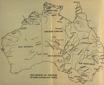
Map, Australia Showing Position of Some Australian Tribes, c1945, c1945
Digitised directly from "The Australian Aborigines: How to understand them" by A.P. ElkinMap of Australia showing states, river system and some Aboriginal Tribes.aboriginal, aborigines, kurnai, worworung, wongaibon, wiradjuri, dieri, wakelbura, pittapitta, waramunga, binbinga, anula, mara, waral, mulluk, larakia, worora, djaru, karadjerri, kogara, wongaii, pankala, tabalde, buandie -
 Federation University Historical Collection
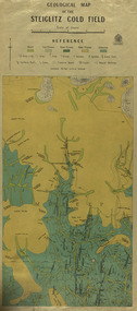
Map, Geological Map of The Stieglitz Gold Field, 1940
At the bottom of the 2nd page, there is text that reads "Geologically and topographically surveyed in 1909 by W.H. Ferguson, Assistant Field Geologist. Published 1940."Rectangular geological map edged in masking tape showing Steiglitz, Victoria. Scale 48 chains to 4 inches.steiglitz, geology, geological map, north albion, moreep, mining, mine, caribald reef, durdidwarrah, gilbraltar hill, mount pleasant gully, township of steiglitz, w.h. ferguson, garibaldi reef, yankee gully, kinglock mine engine shaft, herbert werner frederick de nully, albion gully, virago reef, mulrooney's reef -
 Federation University Historical Collection
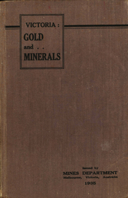
Book, Victoria: Gold and Minerals, 1935, 1935
Hard cover book. Fold out map showing auriferous areas and mineral localities in Victoria, 1935victoria, gold, minerals, 1935, geological map, hydrolic sluicing, panning, pneumatic drill, puddling machine, bendigo, coal mine, wonthaggi, yallourn, jamieson valley, geological school, melbourne university, mount buffalo, electric power station, briquette factory, mines department, george brown, secretary of mines, e.j. hogan, minister of mines, mining -
 Federation University Historical Collection
Photograph - coloured, Department of Lands and Survey, Portion of Victoria showing auriferous areas and mineral localities, 1935, 1935
... E.J. Barker Library (top floor) Mount Helen goldfields Map ...Map included with book "Victoria: Gold and Minerals" issued by Mines Department Victoria, 1935Fold out coloured mapYellow mark indicating depositsvictoria, auriferous areas, mineral localities, department of mines, tin, antimony, copper, silver lead, tungsten, manganese, platinum, iron -
 Federation University Historical Collection
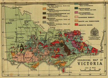
Photograph - colour, William Baragwanath, Department of Mines: Geological map of Victoria, c1935
Photograph included in book "Victoria: Gold and Minerals" issued by Mines Department Victoria, 1935Photographmap, department of mines, victoria, key to land formations, time periods, jurassic, geological map -
 Federation University Historical Collection
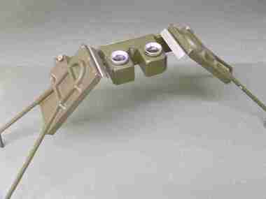
Instrument - Scientific Instruments, Universal Stereoscope
Initially made for and used by the military forces. Subsequently acquired (as army surplus equipment?) by the Ballarat School of Mines. Used in Surveying classes.A stereoscope arranged for positioning over a horizontal surface stored in a sturdy grey wood carry case. Spare set of mirrors attached to inside of box lid.scientific instruments, surveying, ballarat school of mines, stereoscope, map reading -
 Federation University Historical Collection
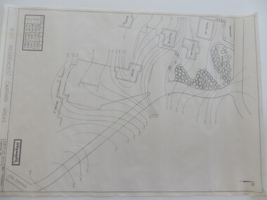
Plan - Contour tracings, Ballarat University College residence carparks and detail survey of Mt Helen campus, 1991/1992
3 ink on tracing paper survey maps .1) Detail survey Mt Helen campus 1992 .2) Top residence car park 1991 .3) BUC residences' car park 1991ink on tracing paper, b.u.c surveys, transpotr, ballarat college of advanced education, mount helen campus, carpark, student residences -
 Federation University Historical Collection
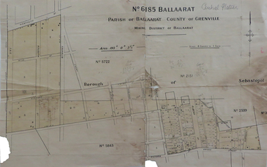
Map, No 6185 Ballaarat Parish of Ballaarat County of Grenville, not dated
... E.J. Barker Library (top floor) Mount Helen goldfields map ...Printed map with pencil inscriptionsmap, parish of ballaarat, grenville county, sebastopol, central company engine house, wesleyan reserve, victoria street, yarrowee street, charlotte st, kyle street -
 Federation University Historical Collection
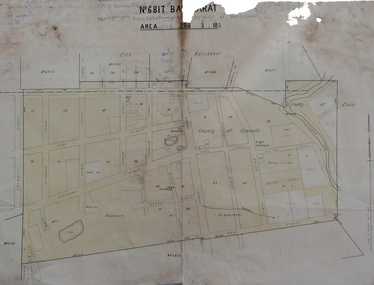
Map, No 6817 Ballaarat, Parish of Ballaarat, Mining District of Ballaarat, c1908
... E.J. Barker Library (top floor) Mount Helen goldfields map ...Printed map with pencil inscriptions on recto and versomap, mining districts, mining district of ballaarat -
 Federation University Historical Collection
Map, Lintons Pre-emptive Section, 1872, 1872
... E.J. Barker Library (top floor) Mount Helen goldfields map ...Printed map with coloured shading by F. W Niven Lydiard Street, Ballaratmap, mining districts, lintons claim, lintons diggings, f w niven, nivens steam lithographic machine, f.w. niven -
 Federation University Historical Collection
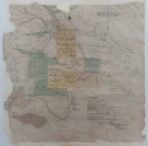
Map, Plan showing Locality of Reported Gold Find District of Tavula, 1935
... E.J. Barker Library (top floor) Mount Helen goldfields map ...Map with coloured shading on paper backed onto linen showing Crown Indian Settlement, Tovatova, Koro, Devotamap, devota, koro, crown indian settlemt, tovatova, tavua -
 Federation University Historical Collection
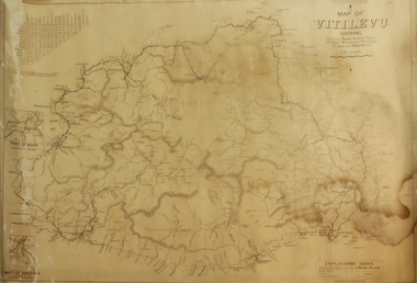
Map, Map of Vitilevu showing vehicular roads, native tracks, villages, provinces, 1935
... E.J. Barker Library (top floor) Mount Helen goldfields map ...Printed map on paper backed onto linen with small inset maps of Nandi and Singatoka map, vitilevu, singatoka, nandi -
 Federation University Historical Collection
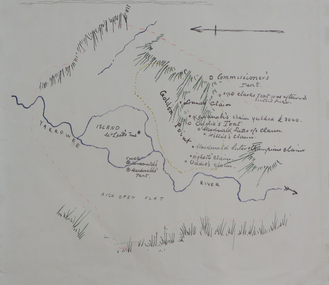
Plan, Dunn's Map of Early Gold Diggers at Golden Point, Ballarat, not dated
... E.J. Barker Library (top floor) Mount Helen goldfields dunn ...Hand drawn map in colour showing Yarrowee River and claims including James Oddie and Highett.dunn, dunn's map, comissioner's tent, oddie's claim, highett's claim, macdonald, suter & co claim, james oddie, golden point, gold discovery -
 Federation University Historical Collection
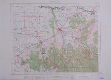
Map, Wangaratta, not dated
Printed colour map on paperwangaratta, broken river, ovens river, benalla, euroa -
 Federation University Historical Collection
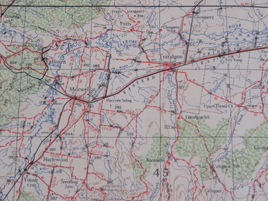
Map, Warragul, 1942, not dated
... E.J. Barker Library (top floor) Mount Helen goldfields ...printed colour mapwarragul -
 Federation University Historical Collection
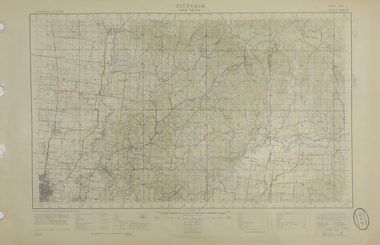
Map, Yan Yean, 1935, 05/1935
... E.J. Barker Library (top floor) Mount Helen goldfields yan ...Printed colour map on paperyan yean -
 Federation University Historical Collection
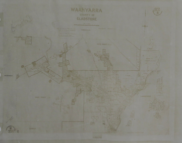
Map, Waanyarra, not dated
... E.J. Barker Library (top floor) Mount Helen goldfields ...Photocopy of mapwaanyarra -
Federation University Historical Collection
Book, George Brown, Prospectors' Guide (Victoria), 1936, 1936
Brown soft covered book with pullout map showing auriferous areas of Victoria. prospecting, gold, geology, quartz reefs, indicators, ballarat indicators, miners' rights, mining leases, forest regulations, equipment, gold cradle, puddling machine, sluice box, whim, whip, california pump, cradle, mining, tools, mining laws -
 Federation University Historical Collection
Book, The Old Pioneers' Memorial History of Melbourne From the Discovery of Port Phillip to the World War, 1924
Blue hard covered book of 494 pages. Images, and a large plan of prominent burials in the Melbourne Old Cemetery, and a Map of Melbourne. melbourne, melbourne cemetery, melbourne old cemetery, john batman, edmund hobson, batman's map, st francis' church, james balfour, mrs hornbrook, paddy's market, wilson hall, working men's college, henry kendall, le souef's cottage, world war one, westernport, melbourne cup, hoddle, collingwood, south melbourne, prahran, richmond, kew, brunswick, coburg, preston, hawthorn, camberwell, nunawading, doncaster, st kilda, brighton, sandringham, cheltenham, caulfield, oalkleigh, footscray, sunshine, north melbourne, carlton, ballarat school of art library, ballarat technical art school, book plate, library plate, hume and hovell's overland journey 1824-5, major mtichell's overland journey, australia felix, booplate, aborigine, aboriginal, captain cook, arthur phillip, isaac smith, george bass, matthew flinders, john murray, catain baudain, captain collins, edward henty, portalnd, map od melbourne in 1938, john pascoe fawkner, the "enterprise: and fawkner's first home, old colonists' homes, rushall crescent north fitszroy, richard bourke, the old melbourne post offfice, old governmnt house, toorak, latrobe's house at jolimont, first melbourne land sale, melbourne water supply, peter henry smith, victorian legislative council opening, map of melbourne and collingwood, prince's bridge, crossing the rivers by punt, f.a> rucker, canvas city emerald hill, arrival of the gold escort in melbourne, the yarra, queen's wharf, tall ships, old st james, mary e. budd, st francis church, michael carr, meolbourne city mission, state library of victoria, melbourne public library, bourke street, angus mcmilan, methodist ladies college, ormond college, armistance celebrations, robert russell, mia mia, theatre royal bouke st, melbourne from flaggstaff hill, federal coffee palace collins st, lord melbourne, melbourne mint, old melbourne town hall, robert russell's melbourne and yarra falls, mandevalle hall, point lansdale lighthouse, wilson's promontory, margaret m. ward cole, williamstown, flinders st melbourne, queenscliff battery, broadmeadows soldiers' camp, embarkation of first troops on the 'ceramic', general monsash, ian hamilton, general bridges, victorian war memorial, national war memorial, st kilda pier, first melbourne cup, hoddle's grid, albert park, melbourne mechanic's institute, st kilda toll gate, munted policeman, springthorpe memorial, james bonwick, mornane's paddock, victorian railways melbourne and surburban lines, carlton gardens, thomas napier, wiliam westgarth, george augustus robinson, william lonsdale, elizabeth mary batman, peomena frances darling batman, dig tree, exhibition of 1854, exhibition of 1866, exhibition buildings, geelong harbour, jubilee lake, port campbell, warrnambool, queenscliff lightboat, batman's first house -
Federation University Historical Collection
Booklet, Little Desert National Park and Wail State Forest Proposed Management Plan, 1991, 11/1991
Grey soft covered report of 80 pages. Includes a pull out map.little desert national park, wait state forest, management plan, horsham, department of conservation and environment, rod gowans, don spence, wimmera river, threatened plants, fauna, flora, birds, mammals, wergaia, scarred trees, mounds, pest plants, pest animals, tourism and recreation, timber, grazing, conservation -
Federation University Historical Collection
Book, Business, Service & Street Directory: Ballarat, Hepburn and Golden Plains Shires, 2011, 2011
Soft covered directory with advertisments, maps, business listings and community services. The cover featurs the Ballarat Botanical Gardens.directory, street directory, business directory, ballarat, hepburn, golden plains -
Federation University Historical Collection
Book, Business, Service & Street Directory: Ballarat, Hepburn and Golden Plains Shires, 2008-9, 2008
Soft covered directory with advertisments, maps, business listings and community services. The cover featurs the Ballarat Avenue of Honour.directory, street directory, business directory, ballarat, hepburn, golden plains -
 Federation University Historical Collection
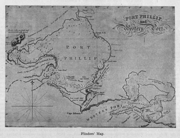
Image, Matthew Flinders' Map of Port Phillip
Scanned from "The Old Pioneers' Memorial History of Melbourne From the Discovery of Port Phillip to the World War".matthew flinders, flinders map, port phillip bay -
 Federation University Historical Collection
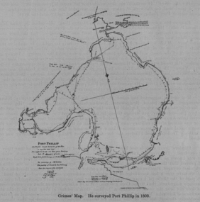
Image, Survey of Port Phillip as Mapped by Grimes
Scanned from "The Old Pioneers' Memorial History of Melbourne From the Discovery of Port Phillip to the World War".port phillip bay, grimes -
 Federation University Historical Collection
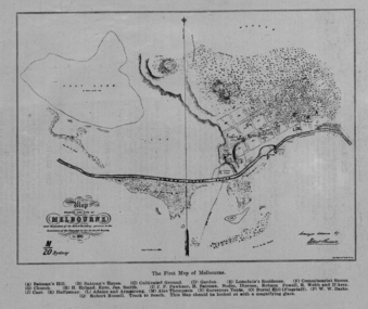
Image, The First Map of Melbourne, 1837
Scanned from "The Old Pioneers' Memorial History of Melbourne From the Discovery of Port Phillip to the World War".First map of Melbourne showing the location of Batman's Hill, Batman's House, Lonsdale's Residence, Commissarist Stores, location of John Falwkner, R. Webb, D'Acry, Carr, Diprose, Nodin, Robson, Alex Thompson, Surveyors tents, Burial Hill (AKA Flagstaff Hill)port phillip bay, batman's hill, batman's house, lonsdale's residence, commissarist stores, john fawkner, r. webb, d'acry, carr, diprose, nodin, robson, alex thompson, surveyors tents, burial hill, flagstaff hill -
 Federation University Historical Collection
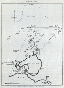
Image, Batman's Map of Port Phillip
Scanned from "The Old Pioneers' Memorial History of Melbourne From the Discovery of Port Phillip to the World War". It is a facsimile map from the House of Commons Reports of Committee.John Batman's map of Port Phillip showing Dutigalla (Batman's Tract), a township reserve, open plains, public common reserve, fresh water"A tract of country [called?] by the native chief of Southern Ausralia to be John Batman 6th June 1935."port phillip bay, john batman, melbourne, iramoo, r. sarsh, river sarsh, river batman, yarra river -
Federation University Historical Collection
Report, Report of Visit to Pumped Storage and Other Instalment in Germany, 1959, 1958
Graham Beanland is a former Principal of the Ballarat School of Mines. The report was prepared as the result of an overseas scholarshipTyped report by Graham H. Beanland. Includes original photographs, and the following sites that were visited - Geesthact, Schluchsee, Brauweiler, Rommerskirchen, Fortuna, Birsfelden, Geesthact Pumped Storage Station. A coloured map of Baden-Wurttemburg is included. graham beanland, geesthacht, schluchsee, brauweile, rommerskirchen, fortuna, birsfelden, geesthact pumped storage station, pumped storage -
 Federation University Historical Collection
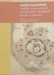
Book, Walata Tyamateetj: A guide to government records about Aboriginal people in Victoria, 2014, 2014
Ochre and yellow covered book of 87 pages with quality photgraphs of public records.non-fictionaboriginal mission stations, plan, aboringal, aborigine, aboriginal records, public record office victoria, national archives of australia, jim berg, port phillip, assimilation, chief protector of aborigines, aboriginal protectorates, board for the protection of aborigines, native police corp, edward stone parker, goulbourn river protectoratewesternport district, gunai-kurnai, coranderrk aboriginal station, lake tyers aboriginal station, antwerp primary school, wimmera river, framlingham aboriginal station, william thomas, map, charles tyers, f.p. strickland, ebernezer -
Federation University Historical Collection
Magazine, Ararat: The Guide, 2000-2001
Yellow and blue soft covered Ararat Community Directoryararat, community directory, gwenda allgood, paul hooper, pat mcaloon, steve shannon, peter o'rorke, ted millear, geoff king, bill braithwaite, ian couper, ian manley, annette newton, lesley harvie, j ward, david hawker, dianne hadden, bruce chamberaine, joe helper, john mcquilten, denis napthine, roger hallam, ararat advertiser, ararat community college, ararat map, grampians soaring club, ararat gaol, ararat town hall, gum san museum, chinese