Showing 4627 items
matching melbourne - maps
-
 4th/19th Prince of Wales's Light Horse Regiment Unit History Room
Maps, Major & Mrs Holt's Battle Map of Gallipoli, 2000
... Macleod melbourne Maps Gallipoli. Holt 97809585229662 Brochure ...Brochure containing battle field maps of Gallipoli campaign. Designed as a guide for visitors97809585229662maps, gallipoli. holt -
 Eltham District Historical Society Inc
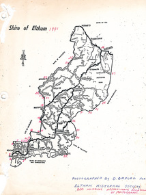
Map, Shire of Eltham (boundaries), 1991
Key to a collection of 35 photos taken by Doug Orford at 35 specific locations along the exact boundary of the then Shire of Eltham. -
 Eltham District Historical Society Inc
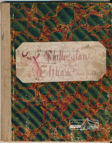
Book, Exercise Book, 1890
Exercise book of William Shillinglaw. Filled with writing exercises and some math problems and map drawings. May have been used as a homework book. All pages headed with day and date. William was one 8 children who attended Eltham Primary School. He was born in 1878 and attended the school between 1883 and 1890 having started there at the age of 4 years and 2 months in April 1882. He left the school in 1890 when 12 years of age. Dates obtained from EPS school attendance rolls. Exercise book last entry is dated June 16th, 1891. One of five items relating to the Shillinglaw Family collectionThe book was owned by William Shillinglaw. This family were pioneer settlers in the Eltham area. William was one of 8 siblings to attend Eltham Primary School. This workbook is a rare local example of the practical classroom education process in the late 1880s and early 1890s.Hardcover with marbled decorative cover with hand made name plate pasted on; 58 pagesCover: ? Shillinglaw Eltham June 17 1891shillinglaw family collection, william shillinglaw, eltham primary school, exercise book -
 Eltham District Historical Society Inc
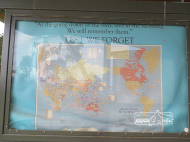
Photograph, Liz Pidgeon, Moor-Rul Viewing Platform Panel: Lest We Forget, 10 August 2016
... melbourne Coloured map of the world on blue including the words ...Coloured map of the world on blue including the words for the "Lest We Forget" lament. The Moor-Rul Viewing Platform, part of the Kangaroo Ground War Memorial Park opened in April 2007. Eight double-sided interpretation panels on the Moor-rul viewing platform highlight the area's Aboriginal and European history of the area and also details of local geology, flora and fauna. These panels feature high quality graphic design and professionally written text. The subjects covered are: ''Womin Je Ka" Welcome The Kulin Nation Singing, Dancing, Ceremony, Celebration This Country, My Home The Highland Taken Auld Lang Syne "Same Land Different Views" Working the Land Food from the Earth or "Earth's Harvest" Lest We Forget, "And with the going down of the Sun .... (3 panels) This Black Earth Those other indigenous inhabitants - Kangaroo Ground's Wildlife Silent Witnesses - Kangaroo Ground's White Manna Gums Belonging A Place of Reverence and A Tower of Strength Souce: EDHS Newsletter No 173 March 2007. As part of a program to acknowledge the Anzac Centenary Nillumbik Shire Council partnered with Yarra Plenty Regional Library to provide a bus tour with commentary of local sites of significance: Shire of Nillumbik World War One Memorials tour, 10 August 2016. These included Eltham township, the Shire of Eltham War Memorial at Kangaroo Ground, Christmas Hills war memorial, Hurstbridge memorial recreation park and finshed at Eltham Library to view the Writing the War exhibtion at Eltham Library Community Gallery. Born Digitalworld war 1, war memorials, shire of nillumbik, moor-rul viewing platform, kangaroo ground, shire of eltham war memorial, interpretative signage, interpretation panel, map, display panel -
 Eltham District Historical Society Inc
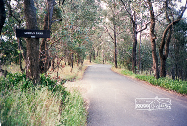
Photograph, Ardean Park, 315 Flat Rock Rd, Hurstbridge
Sold by Fletchers 3 Dec 2015 for $1.26m. See https://www.realestate.com.au/sold/property-house-vic-hurstbridge-121193850 Google Streetview Feb 2014 https://www.google.com.au/maps/@-37.6455525,145.2071828,3a,49.4y,333.82h,88.64t/data=!3m6!1e1!3m4!1sr2PfMo3UeXV_fqSDYToiuA!2e0!7i13312!8i6656Roll of 35mm colour negative film, 2 stripsKodak GA 100 5095shire of eltham, roads, flatrock road, hurstbridge, ardean park, cowan -
 Eltham District Historical Society Inc
Photograph, Liz Pidgeon, Heritage Excursion; Eltham Lower Park Walk and Talk, 1 July 2017, 1 July 2017
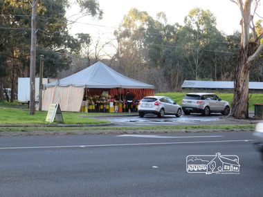
Temporary flower vendor set up in a tent opposite Eltham Lower Park. The flower seller sets up on weekends and offers a convenient drive through service for customers. Goolge maps in February 2021 identified this site as Fleur De Feliss Roadside Store. Heritage Excursion - Saturday 1st July - Eltham Lower Park - Walk and Talk Eltham Lower Park has played an important part in the history of our area since the early days of European settlement when it was used by local residents as an informal racecourse. Prior to that its location at the junction of the Diamond Creek and the Yarra River made it an important meeting place for the Wurundjeri people. The park combines formal elements and sporting facilities with remnant bushland that is of environmental significance. It is home to sporting and horse riding clubs, popular play spaces and the Diamond Valley Miniature Railway, which attracts large numbers of visitors. The park will be the venue for our July excursion which will comprise a walk of about 3.5 km around the park and adjacent areas. Along the way we will discuss the history and natural history of the area. The path along the creek and the river provides a pleasant and scenic walk. This walk on Saturday 1st July is about 3.5 km in length and will take 2 to 2.5 hours. It will start at 2pm at the Main Road car park at the front of the park. (Melway ref 21 H 10). Newsletter No., 234, June 2017 Born Digitalheritage excursion, activities, eltham district historical society, eltham lower park, roadside store, flower vendor, fleur de feliss, tent, drive through, drive thru -
 Eltham District Historical Society Inc
Photograph, Liz Pidgeon, Heritage Excursion; Eltham Lower Park Walk and Talk, 1 July 2017, 1 July 2017
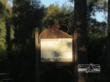
Sign at the front of the park which includes a map. Newsletter No., 234, June 2017 Heritage Excursion - Saturday 1st July - Eltham Lower Park - Walk and Talk Eltham Lower Park has played an important part in the history of our area since the early days of European settlement when it was used by local residents as an informal racecourse. Prior to that its location at the junction of the Diamond Creek and the Yarra River made it an important meeting place for the Wurundjeri people. The park combines formal elements and sporting facilities with remnant bushland that is of environmental significance. It is home to sporting and horse riding clubs, popular play spaces and the Diamond Valley Miniature Railway, which attracts large numbers of visitors. The park will be the venue for our July excursion which will comprise a walk of about 3.5 km around the park and adjacent areas. Along the way we will discuss the history and natural history of the area. The path along the creek and the river provides a pleasant and scenic walk. This walk on Saturday 1st July is about 3.5 km in length and will take 2 to 2.5 hours. It will start at 2pm at the Main Road car park at the front of the park. (Melway ref 21 H 10). Born Digitalelection day, heritage excursion, activities, eltham district historical society, eltham lower park, sign -
 Eltham District Historical Society Inc
Photograph, Liz Pidgeon, Heritage Excursion; Eltham Lower Park Walk and Talk, 1 July 2017, 1 July 2017
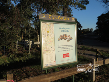
Civic Guide sign near the entrance of Eltham Lower Park with a map of the local area and an advertisement for Eltham College Newsletter No., 234, June 2017 Heritage Excursion - Saturday 1st July - Eltham Lower Park - Walk and Talk Eltham Lower Park has played an important part in the history of our area since the early days of European settlement when it was used by local residents as an informal racecourse. Prior to that its location at the junction of the Diamond Creek and the Yarra River made it an important meeting place for the Wurundjeri people. The park combines formal elements and sporting facilities with remnant bushland that is of environmental significance. It is home to sporting and horse riding clubs, popular play spaces and the Diamond Valley Miniature Railway, which attracts large numbers of visitors. The park will be the venue for our July excursion which will comprise a walk of about 3.5 km around the park and adjacent areas. Along the way we will discuss the history and natural history of the area. The path along the creek and the river provides a pleasant and scenic walk. This walk on Saturday 1st July is about 3.5 km in length and will take 2 to 2.5 hours. It will start at 2pm at the Main Road car park at the front of the park. (Melway ref 21 H 10). Born Digitalheritage excursion, activities, eltham district historical society, eltham lower park, civic guide, eltham college, sign -
 Eltham District Historical Society Inc
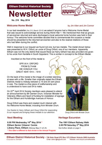
Newsletter, Newsletter, No. 216 May 2014
Contents: • Welcome Home Medal by Jim Allen and Jim Connor • Next Meeting • Heritage Excursion – The 1901 Eltham Railway Walk • May Meeting – Maps, Manuscripts and Menus; telling stories via heritage collections (Liz Pidgeon) • May Excursion – The 1901 Eltham Railway Walk • Subscriptions • Vera Addison • Vale John Cohen OAM 19/9/1919-18/3/2014 • Mayoral Chain of Office • Eltham Library – 20th Anniversary • St Margaret’s Church Eltham • Office Bearers 2014-2015 • And Also • Contacts for the Eltham District Historical Society The Shire of Eltham Historical Society was formed in October 1967. The first newsletter of the Society was issued May 1978 and has been published continuously ever since on a bi-monthly basis. With the cessation of the Shire of Eltham in late 1994, the Society's name was revised to Eltham District Historical Society and this name first appeared with issue No. 103, July 1995. The collection of the Society's newsletters provides a valuable resource on the history of the Society's activities, office bearers and committee members, guest speakers and subjects of historical interest pertinent to the former Shire of Eltham and the Eltham District.A4 photocopied newsletter distributed to membersnewsletter, eltham district historical society, shire of eltham historical society -
 Eltham District Historical Society Inc
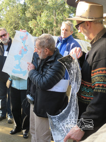
Photograph, Liz Pidgeon, Heritage Excursion; Eltham Lower Park Walk and Talk, 1 July 2017, 1 July 2017
Local Historian Russell Yeoman and EDHS President Jim Connor with a map and aerial photograph of the area the heritage walk will cover. Newsletter No., 234, June 2017 Heritage Excursion - Saturday 1st July - Eltham Lower Park - Walk and Talk Eltham Lower Park has played an important part in the history of our area since the early days of European settlement when it was used by local residents as an informal racecourse. Prior to that its location at the junction of the Diamond Creek and the Yarra River made it an important meeting place for the Wurundjeri people. The park combines formal elements and sporting facilities with remnant bushland that is of environmental significance. It is home to sporting and horse riding clubs, popular play spaces and the Diamond Valley Miniature Railway, which attracts large numbers of visitors. The park will be the venue for our July excursion which will comprise a walk of about 3.5 km around the park and adjacent areas. Along the way we will discuss the history and natural history of the area. The path along the creek and the river provides a pleasant and scenic walk. This walk on Saturday 1st July is about 3.5 km in length and will take 2 to 2.5 hours. It will start at 2pm at the Main Road car park at the front of the park. (Melway ref 21 H 10). Born Digitalheritage excursion, activities, eltham district historical society, eltham lower park, russell yeoman, jim connor, guide -
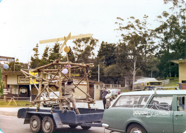
 Eltham District Historical Society Inc
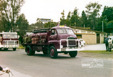
Photograph, Eltham Fire Brigade, Eltham Community Festival Parade, Main Road opposite Wingrove Park, 4 August 1978, 04/08/1978
Eltham Community Festival, 4-13 August 1978 Newsletter No. 3 September 1978 Eltham Community Festival. This year’s Eltham Community Festival was held from August 4th to 13th. The society was involved with the Warrandyte Historical Society in arranging an exhibition at the Community Centre and also provided notes and a map for a self-guided walking tour of historic buildings and locations around Eltham. Copies of notes will continue to be available from the Eltham Shire Offices and the tour may be under-taken at any time. The exhibition was divided into two sections. The Eltham Society displayed early photographs associated with the walking tour, whilst the Warrandyte Society showed their photographs and artefacts of the Warrandyte gold era. An outstanding feature was the large "blow-up" photos of early Warrandyte. Colour photographeltham, main road, eltham festival, alan whitmore estate agents, shell service station, mount pleasant road, parade, parade float, wingrove park, fire brigrade -
 Eltham District Historical Society Inc
Photograph, 2nd Eltham Sea Scouts, Eltham Parade, Main Road opposite Wingrove Park, August 1978, 04/08/1978
Eltham Community Festival, 4-13 August 1978 Newsletter No. 3 September 1978 Eltham Community Festival. This year’s Eltham Community Festival was held from August 4th to 13th. The society was involved with the Warrandyte Historical Society in arranging an exhibition at the Community Centre and also provided notes and a map for a self-guided walking tour of historic buildings and locations around Eltham. Copies of notes will continue to be available from the Eltham Shire Offices and the tour may be under-taken at any time. The exhibition was divided into two sections. The Eltham Society displayed early photographs associated with the walking tour, whilst the Warrandyte Society showed their photographs and artefacts of the Warrandyte gold era. An outstanding feature was the large "blow-up" photos of early Warrandyte. Two colour photographseltham, main road, eltham festival, alan whitmore estate agents, shell service station, mount pleasant road, parade, parade float, wingrove park, 2nd eltham sea scouts -
 Eltham District Historical Society Inc
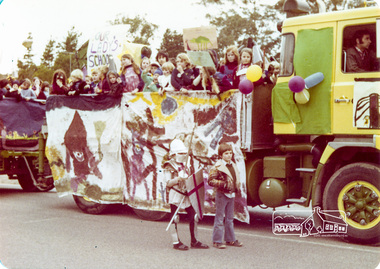
Photograph, Our Lady's School, Eltham Community Festival Parade, Main Road opposite Wingrove Park, 4 August 1978, 04/08/1978
Eltham Community Festival, 4-13 August 1978 Newsletter No. 3 September 1978 Eltham Community Festival. This year’s Eltham Community Festival was held from August 4th to 13th. The society was involved with the Warrandyte Historical Society in arranging an exhibition at the Community Centre and also provided notes and a map for a self-guided walking tour of historic buildings and locations around Eltham. Copies of notes will continue to be available from the Eltham Shire Offices and the tour may be under-taken at any time. The exhibition was divided into two sections. The Eltham Society displayed early photographs associated with the walking tour, whilst the Warrandyte Society showed their photographs and artefacts of the Warrandyte gold era. An outstanding feature was the large "blow-up" photos of early Warrandyte. Colour photographeltham, main road, eltham festival, alan whitmore estate agents, shell service station, mount pleasant road, parade, parade float, wingrove park, our ladys school -
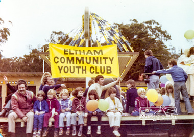 Eltham District Historical Society Inc
Photograph, Eltham Community Youth Club, Eltham Community Festival Parade, Main Road opposite Wingrove Park, 4 August 1978, 04/08/1978
Eltham Community Festival, 4-13 August 1978 Newsletter No. 3 September 1978 Eltham Community Festival. This year’s Eltham Community Festival was held from August 4th to 13th. The society was involved with the Warrandyte Historical Society in arranging an exhibition at the Community Centre and also provided notes and a map for a self-guided walking tour of historic buildings and locations around Eltham. Copies of notes will continue to be available from the Eltham Shire Offices and the tour may be under-taken at any time. The exhibition was divided into two sections. The Eltham Society displayed early photographs associated with the walking tour, whilst the Warrandyte Society showed their photographs and artefacts of the Warrandyte gold era. An outstanding feature was the large "blow-up" photos of early Warrandyte. Colour photographeltham, main road, eltham festival, alan whitmore estate agents, shell service station, mount pleasant road, parade, parade float, wingrove park -
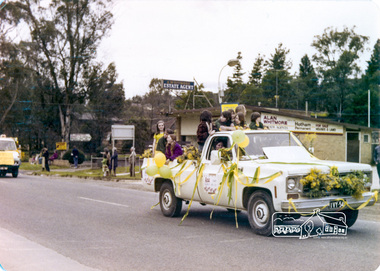 Eltham District Historical Society Inc
Photograph, Eltham Community Festival Parade, Main Road opposite Wingrove Park, 4 August 1978, 04/08/1978
Eltham Community Festival, 4-13 August 1978 Newsletter No. 3 September 1978 Eltham Community Festival. This year’s Eltham Community Festival was held from August 4th to 13th. The society was involved with the Warrandyte Historical Society in arranging an exhibition at the Community Centre and also provided notes and a map for a self-guided walking tour of historic buildings and locations around Eltham. Copies of notes will continue to be available from the Eltham Shire Offices and the tour may be under-taken at any time. The exhibition was divided into two sections. The Eltham Society displayed early photographs associated with the walking tour, whilst the Warrandyte Society showed their photographs and artefacts of the Warrandyte gold era. An outstanding feature was the large "blow-up" photos of early Warrandyte. Colour photographeltham, main road, eltham festival, alan whitmore estate agents, shell service station, mount pleasant road, parade, parade float, wingrove park -
 Eltham District Historical Society Inc
Photograph, Country Womens Association Montmorency, Eltham Community Festival Parade, Main Road opposite Wingrove Park, 4 August 1978, 04/08/1978
Eltham Community Festival, 4-13 August 1978 Second photo of 5 ladies very motion blurred but ladies named are L to R: Edi Levi, Joyce Finster, Thelma Smith, Jean Spencer, Norma Williams. Newsletter No. 3 September 1978 Eltham Community Festival. This year’s Eltham Community Festival was held from August 4th to 13th. The society was involved with the Warrandyte Historical Society in arranging an exhibition at the Community Centre and also provided notes and a map for a self-guided walking tour of historic buildings and locations around Eltham. Copies of notes will continue to be available from the Eltham Shire Offices and the tour may be under-taken at any time. The exhibition was divided into two sections. The Eltham Society displayed early photographs associated with the walking tour, whilst the Warrandyte Society showed their photographs and artefacts of the Warrandyte gold era. An outstanding feature was the large "blow-up" photos of early Warrandyte. Two colour photographs (one very blurry but with members names on it)eltham, main road, eltham festival, alan whitmore estate agents, shell service station, mount pleasant road, parade, parade float, wingrove park, country women's association, montmorency, edi levi, joyce finster, thelma smith, jean spencer, norma williams -
 Eltham District Historical Society Inc
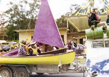
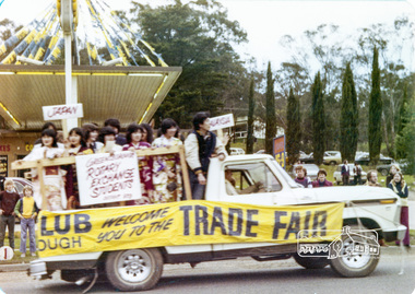
Photograph, Rotary Exchange Students, Eltham Community Festival Parade, Main Road opposite Wingrove Park, 4 August 1978, 04/08/1978
Eltham Community Festival, 4-13 August 1978 Second photo of 5 ladies very motion blurred but ladies named are L to R: Edi Levi, Joyce Finster, Thelma Smith, Jean Spencer, Norma Williams. Newsletter No. 3 September 1978 Eltham Community Festival. This year’s Eltham Community Festival was held from August 4th to 13th. The society was involved with the Warrandyte Historical Society in arranging an exhibition at the Community Centre and also provided notes and a map for a self-guided walking tour of historic buildings and locations around Eltham. Copies of notes will continue to be available from the Eltham Shire Offices and the tour may be under-taken at any time. The exhibition was divided into two sections. The Eltham Society displayed early photographs associated with the walking tour, whilst the Warrandyte Society showed their photographs and artefacts of the Warrandyte gold era. An outstanding feature was the large "blow-up" photos of early Warrandyte. Colour photographeltham, main road, eltham festival, alan whitmore estate agents, shell service station, mount pleasant road, parade, parade float, wingrove park, rotary -
 Eltham District Historical Society Inc
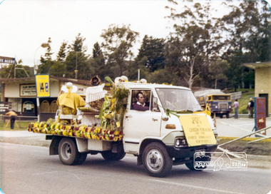
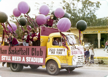
Photograph, Eltham Basketball Club, Eltham Community Festival Parade, Main Road opposite Wingrove Park, 4 August 1978, 04/08/1978
Eltham Community Festival, 4-13 August 1978 Newsletter No. 3 September 1978 Eltham Community Festival. This year’s Eltham Community Festival was held from August 4th to 13th. The society was involved with the Warrandyte Historical Society in arranging an exhibition at the Community Centre and also provided notes and a map for a self-guided walking tour of historic buildings and locations around Eltham. Copies of notes will continue to be available from the Eltham Shire Offices and the tour may be under-taken at any time. The exhibition was divided into two sections. The Eltham Society displayed early photographs associated with the walking tour, whilst the Warrandyte Society showed their photographs and artefacts of the Warrandyte gold era. An outstanding feature was the large "blow-up" photos of early Warrandyte. Colour photographeltham, main road, eltham festival, alan whitmore estate agents, shell service station, mount pleasant road, parade, parade float, wingrove park, eltham basketball club -
 Eltham District Historical Society Inc
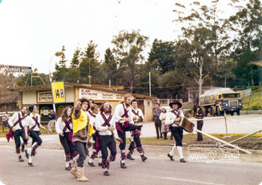
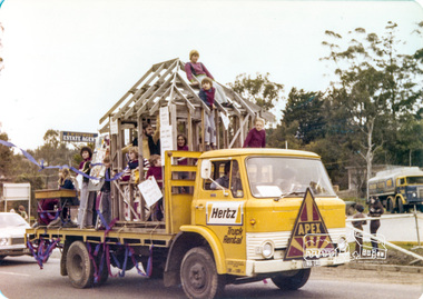
Photograph, Apex, Eltham Parade, Eltham Community Festival Parade, Main Road opposite Wingrove Park, 4 August 1978, 04/08/1978
Eltham Community Festival, 4-13 August 1978 Newsletter No. 3 September 1978 Eltham Community Festival. This year’s Eltham Community Festival was held from August 4th to 13th. The society was involved with the Warrandyte Historical Society in arranging an exhibition at the Community Centre and also provided notes and a map for a self-guided walking tour of historic buildings and locations around Eltham. Copies of notes will continue to be available from the Eltham Shire Offices and the tour may be under-taken at any time. The exhibition was divided into two sections. The Eltham Society displayed early photographs associated with the walking tour, whilst the Warrandyte Society showed their photographs and artefacts of the Warrandyte gold era. An outstanding feature was the large "blow-up" photos of early Warrandyte. Colour photographeltham, main road, eltham festival, alan whitmore estate agents, shell service station, mount pleasant road, parade, parade float, wingrove park, apex -
 Eltham District Historical Society Inc
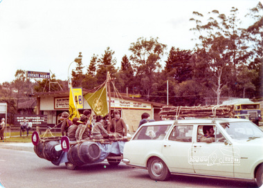
Photograph, !st Eltham Scouts and Cubs, Eltham Community Festival Parade, Main Road opposite Wingrove Park, 4 August 1978, 04/08/1978
Eltham Community Festival, 4-13 August 1978 Newsletter No. 3 September 1978 Eltham Community Festival. This year’s Eltham Community Festival was held from August 4th to 13th. The society was involved with the Warrandyte Historical Society in arranging an exhibition at the Community Centre and also provided notes and a map for a self-guided walking tour of historic buildings and locations around Eltham. Copies of notes will continue to be available from the Eltham Shire Offices and the tour may be under-taken at any time. The exhibition was divided into two sections. The Eltham Society displayed early photographs associated with the walking tour, whilst the Warrandyte Society showed their photographs and artefacts of the Warrandyte gold era. An outstanding feature was the large "blow-up" photos of early Warrandyte. Colour photographeltham, main road, eltham festival, alan whitmore estate agents, shell service station, mount pleasant road, parade, parade float, wingrove park, !st eltham scouts -
 Eltham District Historical Society Inc
Photograph, Montmorency Scouts, Eltham Community Festival Parade, Main Road opposite Wingrove Park, 4 August 1978, 04/08/1978
Eltham Community Festival, 4-13 August 1978 Newsletter No. 3 September 1978 Eltham Community Festival. This year’s Eltham Community Festival was held from August 4th to 13th. The society was involved with the Warrandyte Historical Society in arranging an exhibition at the Community Centre and also provided notes and a map for a self-guided walking tour of historic buildings and locations around Eltham. Copies of notes will continue to be available from the Eltham Shire Offices and the tour may be under-taken at any time. The exhibition was divided into two sections. The Eltham Society displayed early photographs associated with the walking tour, whilst the Warrandyte Society showed their photographs and artefacts of the Warrandyte gold era. An outstanding feature was the large "blow-up" photos of early Warrandyte. Colour photographeltham, main road, eltham festival, alan whitmore estate agents, shell service station, mount pleasant road, parade, parade float, wingrove park -
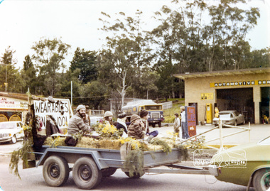 Eltham District Historical Society Inc
Photograph, Wearables Yarn Wool, Eltham Community Festival Parade, Main Road opposite Wingrove Park, 4 August 1978, 04/08/1978
Eltham Community Festival, 4-13 August 1978 Newsletter No. 3 September 1978 Eltham Community Festival. This year’s Eltham Community Festival was held from August 4th to 13th. The society was involved with the Warrandyte Historical Society in arranging an exhibition at the Community Centre and also provided notes and a map for a self-guided walking tour of historic buildings and locations around Eltham. Copies of notes will continue to be available from the Eltham Shire Offices and the tour may be under-taken at any time. The exhibition was divided into two sections. The Eltham Society displayed early photographs associated with the walking tour, whilst the Warrandyte Society showed their photographs and artefacts of the Warrandyte gold era. An outstanding feature was the large "blow-up" photos of early Warrandyte. Colour photographeltham, main road, eltham festival, alan whitmore estate agents, shell service station, mount pleasant road, parade, parade float, wingrove park -
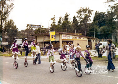 Eltham District Historical Society Inc
Photograph, Mono cyclists, Eltham Parade, Eltham Community Festival Parade, Main Road opposite Wingrove Park, 4 August 1978, 04/08/1978
Eltham Community Festival, 4-13 August 1978 Newsletter No. 3 September 1978 Eltham Community Festival. This year’s Eltham Community Festival was held from August 4th to 13th. The society was involved with the Warrandyte Historical Society in arranging an exhibition at the Community Centre and also provided notes and a map for a self-guided walking tour of historic buildings and locations around Eltham. Copies of notes will continue to be available from the Eltham Shire Offices and the tour may be under-taken at any time. The exhibition was divided into two sections. The Eltham Society displayed early photographs associated with the walking tour, whilst the Warrandyte Society showed their photographs and artefacts of the Warrandyte gold era. An outstanding feature was the large "blow-up" photos of early Warrandyte. Colour photographeltham, main road, eltham festival, alan whitmore estate agents, shell service station, mount pleasant road, parade, parade float, wingrove park -
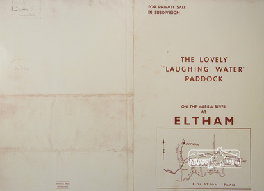 Eltham District Historical Society Inc
Photograph, For Private Sale in Subdivisions; The Lovely "Laughing Water" Paddock on the Yarra River at Eltham
Private sale of the "Laughing Water" paddock in subdivision; 5 river frontages with weatherboard villa on Lot 8; 6 woodland blocks of 5 and 6 acres. Sole Agent: Edward Haughton, 379 Collins Street, Melbourne Location plan and subdivision mapA3 colour photographic print from digital image of sales brochure and A4 reproduction of price listlaughing waters, edward haughton, real estate agent, eltham -
 Eltham District Historical Society Inc
Newsletter, Newsletter, No. 97 July 1994
Contents: • Next meeting, Main Road, Eltham; Filling in the Map • July Meeting • The Shire of Eltham 1871-1994? • The New Eltham Library • The Warrandyte Mystery Tour May 29th 1994 by Bettina Woodburn • Should we do some forward planning on the past for the future? By Harry Gilham • Other News The Shire of Eltham Historical Society was formed in October 1967. The first newsletter of the Society was issued May 1978 and has been published continuously ever since on a bi-monthly basis. With the cessation of the Shire of Eltham in late 1994, the Society's name was revised to Eltham District Historical Society and this name first appeared with issue No. 103, July 1995. The collection of the Society's newsletters provides a valuable resource on the history of the Society's activities, office bearers and committee members, guest speakers and subjects of historical interest pertinent to the former Shire of Eltham and the Eltham District.A4 photocopied newsletter distributed to membersnewsletter, eltham district historical society, shire of eltham historical society -
 Eltham District Historical Society Inc
Newsletter, Newsletter, No. 98 September 1994
Contents: • Next meeting, Main Road, Eltham; Filling in the Map • July Meeting • The Shire of Eltham 1871-1994? • The New Eltham Library • The Warrandyte Mystery Tour May 29th 1994 by Bettina Woodburn • Should we do some forward planning on the past for the future? By Harry Gilham • Other News The Shire of Eltham Historical Society was formed in October 1967. The first newsletter of the Society was issued May 1978 and has been published continuously ever since on a bi-monthly basis. With the cessation of the Shire of Eltham in late 1994, the Society's name was revised to Eltham District Historical Society and this name first appeared with issue No. 103, July 1995. The collection of the Society's newsletters provides a valuable resource on the history of the Society's activities, office bearers and committee members, guest speakers and subjects of historical interest pertinent to the former Shire of Eltham and the Eltham District.A4 photocopied newsletter distributed to membersnewsletter, eltham district historical society, shire of eltham historical society -
 Eltham District Historical Society Inc
Newsletter, Newsletter, No. 129 November 1999
Contents: • Next meeting, The Society’s Map Collection; Introduced by Russell Yeoman • November Meeting • Christmas Function • Society Activities • Tarcoola Press • Museum Open Day • Aboriginal Cultural Heritage Workshop • The Shire of Eltham War memorial, Kangaroo Ground • Other News Items The Shire of Eltham Historical Society was formed in October 1967. The first newsletter of the Society was issued May 1978 and has been published continuously ever since on a bi-monthly basis. With the cessation of the Shire of Eltham in late 1994, the Society's name was revised to Eltham District Historical Society and this name first appeared with issue No. 103, July 1995. The collection of the Society's newsletters provides a valuable resource on the history of the Society's activities, office bearers and committee members, guest speakers and subjects of historical interest pertinent to the former Shire of Eltham and the Eltham District.A4 photocopied newsletter distributed to membersnewsletter, eltham district historical society, shire of eltham historical society -
 Eltham District Historical Society Inc
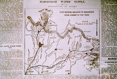
Photograph, Map showing the Maroondah system
Photograph of newspaper article (extract)maroondah dam, maroondah aqueduct -
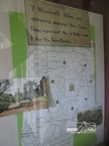 Eltham District Historical Society Inc
Photograph, Kangaroo Ground War Memorial Park: Photo display, 10 August 2016
Display in glass cabinet at the base of the stairs at the tower at Kangaroo Ground. 7 windmill palms are growing around the tower. They represent 6 states and 1 for the Territories with map and photo. As part of a program to acknowledge the Anzac Centenary Nillumbik Shire Council partnered with Yarra Plenty Regional Library to provide a bus tour with commentary of local sites of significance. These included Eltham township, the Shire of Eltham War Memorial at Kangaroo Ground, Christmas Hills, Hurstbridge memorial recreation park and finished at Eltham Library to view the Writing the War exhibtion at Eltham Library Community Gallery. Born Digitalworld war 1, war memorials, shire of nillumbik, heritage display, shire of eltham war memorial, kangaroo ground