Showing 25281 items
matching north-coombes
-
 Melbourne Tram Museum
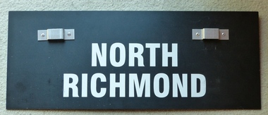
Sign, Yarra Trams, "St Kilda Beach", "North Richmond", c2010
Auxiliary board or sign for the front of tramcars providing destination details - using heavy stiff plastic black board, with the words "St Kilda Beach" on one side and "North Richmond" on the other. Letters formed from white plastic adhesive material. Would have been used on the route 78 service. Has two aluminium pressed metal lugs on either pop riveted to the board.trams, tramways, sign, north richmond, yarra trams, st kilda beach -
 Mission to Seafarers Victoria
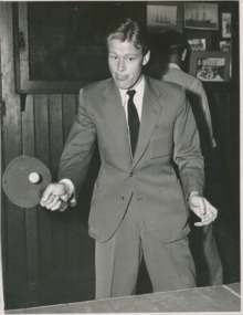
Photograph, Argus newspaper, John N. Thompson, a teenager from North Shields, England, plays table tennis, February 1952
One of three images featured in an article, published in the Argus in 1952, about the lonely life of a sailor and the entertainment at the Mission to Seamen Melbourne. The legend for the picture mentions : "John N. Thompson, a teenager from North Shields, England, plays table tennis."An identifiable image of a visiting seafarer at the Mission to Seamen, Melbourne in the 1950s. In the background we can see some photographs of crews and ships that are still in the collection.Black and white gloss photographic print depicting a young man in suit playing table tennis in the Mission to Seafarers on verso: indigo blue ink stamp : COPYRIGHT PHOTOGRAPH .../ .../ The Argus MELBOURNE AUSTRALIA / Negative no [in pencil] AG991(B) Reference No [ blank] At lwr right corner in pencil: "PH-8"table tennis, seafarer, shore leave, ping pong, sports, games, mission to seamen, seaman's mission, mission to seafarers, john n. thompson, north shields, england, sailors, costume, flinders street, ship crew, argus -
 Melbourne Tram Museum
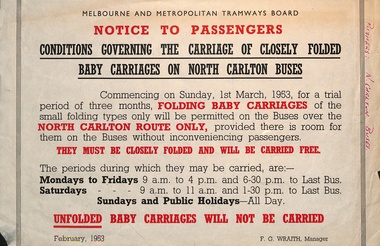
Document - Notice to Passengers, Melbourne & Metropolitan Tramways Board (MMTB), "Baby carriages on North Carlton buses", Feb 1963
Notice to passengers about the conditions of carriage of closely folded baby carriages on North Carlton buses, commencing 1/3/1953 - on trial for 3 months, carried free during off-peak hours. Signed F G Wraith as Manager.Yields information about the carriage of baby carriages on buses.Notice - printed on special size paper.Has in red ink on right hand edge "pushers N Carlton buses"tramways, buses, baby carriages, north carlton -
 Melbourne Tram Museum
Document - Notice to Passengers, Melbourne & Metropolitan Tramways Board (MMTB), "Baby carriages on North Carlton buses", Feb 1953
Notice to passengers about the conditions of carriage of closely folded baby carriages on North Carlton buses, commencing 1/3/1953 - on trial for 3 months, carried free during off-peak hours. Signed F G Wraith as Manager.Yields information about the carriage of baby carriages on buses.Notice - printed on special size paper.Has in red ink on right hand edge "pushers N Carlton buses"tramways, buses, baby carriages, north carlton -
 Lara RSL Sub Branch
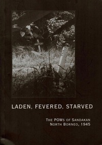
Book, Orders of Service Sandakan, Laden, Fevered, Starved the POWs Of Sandakan North Borneo, 1945, 1999
Publication of Book on the Death Marches from Sandakan Borneo in 1945. Of 2700 prisoners, 6 survived Book and Booklets on the memorial Service held in March of 1999 commemorating the Borneo Death Marches of the POWs From Sandakan North Borneo. Memorial Service honouring those who died and survived the Death Marches in 1999! book, 4 Orders of Service Booklets 23 Coloured photos of memorial services Emails on A4 paper Book - Laden, Fevered , Starved The POWs of Sandakan North Borneo Sandakan Memorial Park Order of Ceremony Opening of the Commemorative Pavilion Order of Service Dedication of the Sanadakan Memorial Labuan War Cemetery Order of Service Ranau Order of Service Kranji War Cemetery Changi Memorial Chapel Orders of Service death march, sandakan borneo labuan ranau kranji, owen campbell -
 Stawell Historical Society Inc
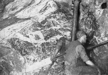
Photograph, Magdala-Cum-Moonlight Mine Looking North West & with 2 miners using a modern rock drill 1902
Mining Scene of Drilling in Underground Magdala-Cum-Moonlight Mine 1902. A stope in rich stone looking North West. Some of the miners on the Magdala mine had early versions of the modern rock drill. Two of the miners are pictured here drilling in the rock face.Two miners underground working a rock drill stawell mining -
 Melbourne Tram Museum
Pamphlet, The Met, "North East Travel Come Aboard - Bundoora - RMIT Route 86", Oct. 1995
Folded full colour printed on glossy paper pamphlet titled "North East Travel Come Aboard - Bundoora - RMIT Route 86" for the opening of the Bundoora tramway extension 12 October 1995, with a complimentary ticket. Gives details of the extension to the RMIT Campus at Bundoora, associated bus routes and the companies operating them, RMIT launch celebrations, and a map. Published by The Met, has logos. Two copies held.trams, tramways, bundoora, route 86, opening, rmit -
 Melbourne Tram Museum
Photograph - Digital Image, Kevin O'Reilly, Kew Junction from the north east, towards the city, c1930's
Image from CD (Compact Diskette for use in computers) - see Reg Item 135. Image titled "Kew Junction' on CD, of looking Kew Junction from the north east, towards the city, shows the Kew railway station precinct. Has a inbound W class tram picking up passengers at the Kew Post Office. A summer day. Possibly late 1920's, early 1930's.trams, tramways, kew, kew junction, kew post office, high st -
 Lakes Entrance Historical Society
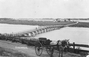
Postcard - North Arm bridge. Lakes Entrance Victoria c1900, Cooper Alexander, 1900c
CunninghameSepia coloured postcard of first bridge over North Arm, showing view of town buildings, including Club Hotel; sand hummocks; Cunninghame Arm; die back of melaleuca on sand flats. In foreground post and rail fence beside road, two wheeled horse drawn vehicle, jinker, with grey horse standing in shafts. Ten or eleven people standing on bridge. Lakes Entrance Victoriatopography, bridges, transport -
 Eltham District Historical Society Inc
Negative - Photograph, Unidentified residential street, possibly Eltham North, c. Oct. 1989
View of rollover kerbing and residential streetscape with plantings on the nature strip. Previous frame was Looking north along Ryans Road at intersection with Kerrie Crescent, Eltham. This was the last frame on the roll of film. There are two slide transparencies shot at the same time Cross Ref: 04174 and 04175Roll of 35mm colour negative film, 1 stripsFuji 100eltham north, houses, residential, streets, streetscape, unidentified, infrastructure -
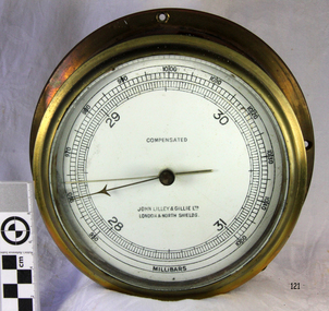 Flagstaff Hill Maritime Museum and Village
Instrument - Barometer, 1952
Mr John Wilson Gillie was born on the 31st of March 1864. On the 31st of July 1880 he was apprenticed for four years to J.J. Wilson and Sons, Nautical Instrument Makers of Sunderland. Following the apprenticeship he spent six months to a year as an ‘improver’ in Glasgow, and then started a new company ‘Wilson and Gillie’ in North Shields. At this time sail had just given way to steam and wooden ships to steel, and the railways were competing with colliers for the carrying of coal from the North East of England to London and the South. In 1858 only seven out of 44 shipyards on the Tyne were using iron, but by 1862 there were ten, employing around 4,000 men. These changes had a significant effect on nautical instrument manufacturers, as the magnetic compass for a wooden sailing vessel was very simple and required little in the way of compensation. For steel vessels much more was required and this was a period of great development, both in the compass bowl and the binnacle in which it was housed. In 1870 Sir William Thomson (later Lord Kelvin) designed his dry card standard compass, which completely replaced all previous designs. Wilson and Gillie started as agents for the Thomson compass, but later J.W. Gillie, using similar principles, redesigned the compass suspension and patented the ‘UNIT’ standard compass. It became popular with local shipowners and shipbuilders. In 1910 the firm of John Lilley and Son (which had been established in London in 1812), found themselves in financial difficulties and were saved with the help of John Wilson Gillie, who established, on the 8th of August 1911, a new firm of John Lilley and Son Limited. John Lilley and Son had been the sole London agents for Sir William Thomson, a very enviable position during this period, when the Thomson compass led the field. Unfortunately, Mr. Lilley had quarreled with the Glasgow company, who withdrew the agency and established their own branch in London (later to become Kelvin White and Hutton). On November 7th 1913, the firm of John Lilley and Son Limited of London amalgamated with Wilson and Gillie of North Shields, and after this date instruments manufactured by the two companies bore the name John Lilley and Son Limited of London and North Shields. During the 1930s many of the London nautical instrument makers were in difficulties, including John Lilley and Son Limited and Reynolds and Son, Dobbie and Clyde Limited, and Mr. J.W. Gillie arranged an amalgamation between these two companies. The new firm became Lilley and Reynolds Limited. In 1943, with estate duties in mind, the North Shields company was reconstituted and took the name of John Lilley and Gillie Limited, although the shareholders, directors and personnel remained unchanged In the early 1970s Lilley and Gillie developed close links with Observator in Rotterdam, who manufactured one of the first fully reliable transmitting magnetic compass systems. The Observator shareholders, Holland America Line, bought the share capital of John Lilley and Gillie Limited., but retained all the personnel and the directors. Tug Melbourne: The barometer was salvaged from a 496-ton tug that had been built in 1952 and had sunk in Port Philip Bay on the 9th of August 1972 after a collision with the SS Nieuw Holland, in 1973 it had been raised and scraped at this time the barometer was salvaged. The tug had been renamed from the Howard Smith to the “Melbourne” after the Adelaide Steamship Co was taken over by Howard Smith& Co, who were heavily involved in towage, salvage and the stevedoring industries in 1961.The significance is that the item was on a vessel that was evolved in a serious collision in Port Philip Bay in 1972. It is linked with the activities of the Port at that time and helps to form a picture of what the maritime industries that operated from Port Melbourne were like and the activities that stevedore and towage companies underwent.Ship Barometer, in brass caseInscribed "Compensated" , "John Lilley & Gillie Ltd London & North Shields." and "Millibars".flagstaff hill, warrnambool, shipwrecked coast, flagstaff hill maritime museum, maritime museum, shipwreck coast, flagstaff hill maritime village, great ocean road, barometer, ship's barometer, weather instrument, john lilley & gillie ltd, shipwreck artefact, the tigboat melbourne, north shields, howard smith, the melbourne, salvage -
 Greensborough Historical Society
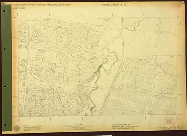
Map, Melbourne and Metropolitan Board of Works. Survey Division, MMBW, Yarra 2500 / 15.22. Eltham North. Allendale Road, 1979_08
Melbourne and Metropolitan Board of Works. Yarra 2500 [base map] 15.22. Eltham North, Allendale Road. Parish of Nillumbik. Municipalities of Eltham 238 and Diamond Valley 257. Prominent streets include: Allendale Road, Godber Road and Ryans Road. Features include the Diamond Creek.MMBW Map in 1:2500 [scale] series. Cream parchment with green tape reinforcing on edges and punched holes on left edge.mmbw, melbourne and metropolitan board of works, shire of diamond valley, nillumbik, eltham - maps -
 Greensborough Historical Society
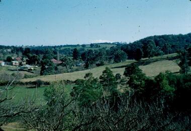
Photograph - Digital Image, Blackjack from the north west, 1954_
Blackjack from the north west. The Blackjack property, house and acres of fruit orchards ran down to the Plenty River off Hume Street Greensborough and was the home of the Robinson family to late 1956. The photographs were taken as slides by Frank Robinson and digitised by his son James in 2015.Digital copy of colour photograph.blackjack, robinson family -
 Greensborough Historical Society
Poster - Planning Document, Shire of Diamond Valley et al, Subdivision Plan # 1044 - Parish of Nillumbik, County Bourke, Crown Allotment B Section 12, Eltham North, 1981-1987
Subdivision Plan # 1044 - Parish of Nillumbik, County Bourke, Crown Allotment B Section 12, Eltham North. This subdivision plan includes Weidlich Road and St Clems Street. The developer for this subdivision is Taunton Developments and the Surveyors are Fisher Cleeland Turner & Dwyer Vic, Surveyors and Engineers.An example of hard copy subdivision plans from the Greensborough area. Mainly from the Shire of Diamond Valley era (1964-1994).Plan (single sided) mounted on heavy card. Stamped and handwritten Council permissions, dates and other details. subdivision plans, shire of diamond valley, taunton developments -
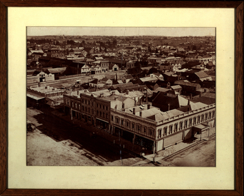 Federation University Historical Collection
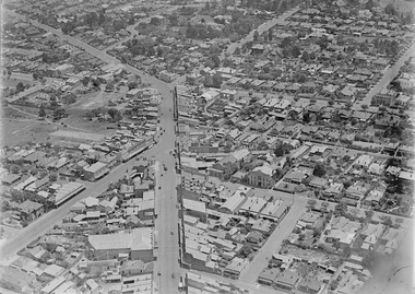
Photograph - Sepia, Ballarat Looking North over Sturt Street and Armstrong Street, 1878
Framed sepia photograph showing Ballarat looking north over Sturt Street from Armstrong Street. The photograph was taken soon after the tower of the Ballarat Town Hall was built. Businesses shown in the photograph include Criterion House, W. Proctor Coach Builder, Lestor's Family Hotel, City Shoing Forge, Tattersall's Hotel, Burke's Hotel, Hislop's Hotel, Bell and Wright's Timber Yard, Mrs Binstedballarat, sturt street, armstrong street, ballarat town hall, ballarat townscape, william bardwell, fotobiennale -
 Linton and District Historical Society Inc
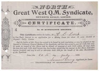
Certificate - Mining Lease, North Great West Q.M. Syndicate, Bryant's Gully, Linton, 1899, 1899
Grey paper, black printing, headed North Great West Q.M. Syndicate, dated 24th July 1899, signed Samuel Devy. Decorative design printed in left hand margin. Number "4" on certificate. Serrated left edge of certificate suggests it was detached from a booklet or form. The certificate was issued to A. C. Cork and entitled him to a one-tenth interest in an application for a mining lease at Bryant's Gully, Linton.mining, leases, north great west q.m. syndicate, bryant's gully, linton, a.c. cork -
 Melbourne Tram Museum
Document, Peter Duckett, "North Melbourne electric Tramway and Lighting Company", late 1940's?
Manuscript - 3 foolscap typed - 1st page a title page, titled "North Melbourne electric Tramway and Lighting Company", written by Peter Duckett. Not dated, possibly late 1940's. Outlines the history of the formation of the company, the routes, track construction, depot, power house, car barn, rolling stock, tramcars, overhead and take over by the MMTB - "what is now one of the worlds finest electric tramway undertakings."trams, tramways, nmetl, essendon, keilor rd, saltwater river, track construction, essendon depot, power station -
 Stawell Historical Society Inc
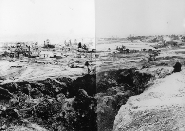
Photograph, View from Big Hill Looking North to Newington Road
Mining Scene. In foreground is Scotts Open Cut, on the left is the Great Northern mine, behind that is the Oriental Mine and the two shafts of the North Cross mines. On the upper right is the Magdala Mine. The mines on the horizon could be the Prince Alfred, Prince Patrick, Newington and Pleasant Creek or Little Newington Mine.B/W Scene Man sitting above open cut, looking at buildings and poppet headsstawell, gold mining -
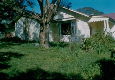
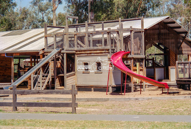
 Eltham District Historical Society Inc
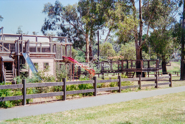
Negative - Photograph, Eltham North Adventure Playground, Wattletree Road, Eltham, 1998c
A community group project steered by Bambi McLean led to the construction of the Eltham North Adventure Playground which opened off Wattletree Road in 1995. The structure was mainly wooden and included an undercover element with slides and areas to climb. It was destroyed by fire in 2017. A new adventure playground was built in 2018.Roll of 35mm colour negative film, 8 strips and associated 10 x 15 cm colour printKodak Gold 100-5north eltham, north eltham adventure playground, wattletree road -
 Eltham District Historical Society Inc
Negative - Photograph, Eltham North Adventure Playground, Wattletree Road, Eltham, 1998c
A community group project steered by Bambi McLean led to the construction of the Eltham North Adventure Playground which opened off Wattletree Road in 1995. The structure was mainly wooden and included an undercover element with slides and areas to climb. It was destroyed by fire in 2017. A new adventure playground was built in 2018.Roll of 35mm colour negative film, 8 strips and associated 10 x 15 cm colour printKodak Gold 100-5north eltham, north eltham adventure playground, wattletree road -
Bendigo Historical Society Inc.
Archive - MCCOLL, RANKIN AND STANISTREET COLLECTION: NORTH DEBORAH GMC N L - MINE BOX, 1940's
Mining box. Metal box, painted dark blue, formerly box number 474 - Now North Deborah Mining Box 19. Tag affixed to front 'box 474'. North Deborah written on brown paper label on the front of the box. Box contains various documents relating to the North Deborah Mine. Documents are individually catalogued within box.North Deborah on labelmining, business, north deborah mining box 19, mccoll, rankin & stanistreet, north deborah gmc n l, gold mining, mining box -
 Greensborough Historical Society
Photograph - Digital image, Frank Robinson, Looking north from the top orchard of Blackjack, 1954_
Looking north from the top orchard of Blackjack. The Blackjack property, house and acres of fruit orchards ran down to the Plenty River off Hume Street Greensborough and was the home of the Robinson family to late 1956. The photographs were taken as slides by Frank Robinson and digitised by his son James in 2015.Digital copy of colour photograph.blackjack, robinson family -
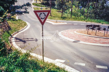 Eltham District Historical Society Inc
Photograph, Looking north along Ryans Road at intersection with Kerrie Crescent, Eltham, c.October 1989, 1989
Ryans Road was reconstructed and sealed to the north of Kerrie Crescent in 1983. Roundabout and southern reconstruction added later. This photo is probably shortly after construction of roundabout (before 1991 when Doug Orford photographed all the Shire boundaries as roundabout was well planted at that stage) Cross Ref: 04070 and 01878-25Roll of 35mm colour negative film, 1 stripsFuji 100eltham north, kerrie crescent, round about, ryans road, streets -
 Ringwood and District Historical Society
Photographs, 1979-80 MMBW pipe line project at Hubbard Reserve, North Ringwood � Compressor unit in backyard
Part of a 43-photo record of the MMBW�s engineering feat in drilling a 12 inch pipe line up to 40 feet deep through rock hardened by volcanic action associated with geological fault that occurs along the line. The work took place from October 1979 to May 1980 on the southern boundary of Hubbard Reserve, North Ringwood. The collection was presented to the Ringwood Historical Research Group by J Clarke on 9th June 1980.E560 N23 Jan 1980 A43 Compressor unit in backyard of 39 Burlock Avenue -
 Ringwood and District Historical Society
Photographs, 1979-80 MMBW pipe line project at Hubbard Reserve, North Ringwood � Work on boring mole pit
Part of a 43-photo record of the MMBW�s engineering feat in drilling a 12 inch pipe line up to 40 feet deep through rock hardened by volcanic action associated with geological fault that occurs along the line. The work took place from October 1979 to May 1980 on the southern boundary of Hubbard Reserve, North Ringwood. The collection was presented to the Ringwood Historical Research Group by J Clarke on 9th June 1980.E560 N22Jan 1980 A43 Work on mole boring pit in 39 Burlock Avenue backyard -
 Ringwood and District Historical Society
Photographs, 1979-80 MMBW pipe line project at Hubbard Reserve, North Ringwood � Filling at 29 Burlock Avenue
Part of a 43-photo record of the MMBW�s engineering feat in drilling a 12 inch pipe line up to 40 feet deep through rock hardened by volcanic action associated with geological fault that occurs along the line. The work took place from October 1979 to May 1980 on the southern boundary of Hubbard Reserve, North Ringwood. The collection was presented to the Ringwood Historical Research Group by J Clarke on 9th June 1980.E560 N10 Dec 1979 A43 Filling at 29 Burlock Avenue -
 Ringwood and District Historical Society
Photographs, 1979-80 MMBW pipe line project at Hubbard Reserve, North Ringwood � Filling behind 29 Burlock Avenue just off sewer line
Part of a 43-photo record of the MMBW�s engineering feat in drilling a 12 inch pipe line up to 40 feet deep through rock hardened by volcanic action associated with geological fault that occurs along the line. The work took place from October 1979 to May 1980 on the southern boundary of Hubbard Reserve, North Ringwood. The collection was presented to the Ringwood Historical Research Group by J Clarke on 9th June 1980.E560 N9 Dec 1979 A43 Filling behind 29 Burlock Avenue just off sewer line -
 Ringwood and District Historical Society
Photographs, 1979-80 MMBW pipe line project at Hubbard Reserve, North Ringwood � Filling at 29 Burlock Avenue
Part of a 43-photo record of the MMBW�s engineering feat in drilling a 12 inch pipe line up to 40 feet deep through rock hardened by volcanic action associated with geological fault that occurs along the line. The work took place from October 1979 to May 1980 on the southern boundary of Hubbard Reserve, North Ringwood. The collection was presented to the Ringwood Historical Research Group by J Clarke on 9th June 1980.E560 N11 Dec 1979 A43 Filling at 29 Burlock Avenue -
 Ringwood and District Historical Society
Photographs, 1979-80 MMBW pipe line project at Hubbard Reserve, North Ringwood � Closeup of revolving airwinch near Hibberd's house
Part of a 43-photo record of the MMBW�s engineering feat in drilling a 12 inch pipe line up to 40 feet deep through rock hardened by volcanic action associated with geological fault that occurs along the line. The work took place from October 1979 to May 1980 on the southern boundary of Hubbard Reserve, North Ringwood. The collection was presented to the Ringwood Historical Research Group by J Clarke on 9th June 1980.E560 N31 Jan 1980 A43 Closeup of revolving airwinch near Hibberd's house -
 Ringwood and District Historical Society
Photographs, 1979-80 MMBW pipe line project at Hubbard Reserve, North Ringwood � Grating over hole in Chalkley's 41 Burlock Avenue
Part of a 43-photo record of the MMBW�s engineering feat in drilling a 12 inch pipe line up to 40 feet deep through rock hardened by volcanic action associated with geological fault that occurs along the line. The work took place from October 1979 to May 1980 on the southern boundary of Hubbard Reserve, North Ringwood. The collection was presented to the Ringwood Historical Research Group by J Clarke on 9th June 1980.E560 N25 Jan 1980 A43 Grating over hole 37 feet deep in Chalkley's 41 Burlock Avenue (lot 8)