Showing 2630 items
matching otway-reef
-
 Bendigo Historical Society Inc.
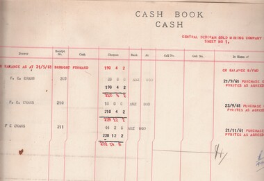
Book - MCCOLL, RANKIN AND STANISTREET COLLECTION: SHARE TRANSFER JOURNAL ALL COMPANIES, 1957/60
Book; Cloth bound loose leaf folder contains tabbed dividers for many mining companies, but, most are empty - Nell Gwynne Reef No Liability sheet No. 4. North Deborah Mining Company N.L. sheets 120-158. North Deborah Mining Co. N.L. (contributing) 64/69. Typewritten sheets. Share Transfer Journal - all companies.MCCOLL RANKIN & STANISTREETorganisation, industry, accounting., mccoll rankin & stanistreet -
 Bendigo Historical Society Inc.
Document - LANSELL'S BIG 180 MINE - PRODUCTION NOTES FOR LANSELL'S 180 MINE
Two handwritten pages of production for Lansell's 180 Mine on the New Chum Reef. Notes give the name of the mine, depth, year, ounces of gold produced and remarks. Mentioned are: Early Workings, Weymouth, Wittschieler & Co, Lansell's 180, Lansell's Estate, Endeavour Co (South Block), J. N. Macartney. Both pages are almost the same. They are page No 111.document, gold, lansell's big 180 mine, lansell's big 180 mine, production notes for lansell's 180 mine, weymouth, wittschieler, ballerstedt & co, lansell's 180, lansell's estate. endeavour co (south block), j n macartney, production statistics b m n l page 111, bendigo goldfields history & production, general index of coys & reefs -
Bendigo Historical Society Inc.
Document - NEW CHUM RAILWAY MINE - NOTES ON THE NEW CHUM RAILWAY MINE
Handwritten notes on the New Chum Railway Mine on the New Chum Line of Reef. Notes include depth of shaft, (At the time, the New Chum Railway Mine and the Victoria Quartz were the deepest in the world), size of lease, locality, plant, engine houses, crushing battery, early history, where the best gold was found, prominence, total gold production and dividends.document, gold, new chum railway mine, new chum railway mine, notes on the new chum railway mine, victoria quartz, great extended hustler's coy, w d c denovan, mr piper, rourke & henderson's claim, young chum reef, thorpe's reef, shenandoah reef, mines dept. special edition australian mining standard 1/6/1899, mines dept booklet bendigo goldfield geo brown 1936, annals of bendigo mining sections 1880 to 1910, a richardson -
Bendigo Historical Society Inc.
Map - NEW CHUM & VICTORIA LINES OF REEF - PLAN OF NEW CHUM & VICTORIA LINES OF REEF
Two pages of a Plan of New Chum & Victoria Lines of Reef, compiled by G. W. Hart. Taken from J. N. Macartney's G'Fields Registry for 1871. Plan shows leases from High Street to California Gully. Location of the Manchester Arms, British & American Hotel and the Quartz Miners Arms are shown. Townships of Long Gully and Ironbark are shown.map, goldfields, new chum & victoria lines of reef, plan of new chum & victoria lines of reef, victoria catharine g m coy, thornton & co, extd victoria reef g m co, ural tribute compy, nil desperandum compy, koch, north victoria g m co, danger hill coy, north endeavour coy, wheadon & co, pilot co, north energetic co, energetic compy, endeavour company, hercules co, victoria gold mines compy, iron duke g m co, golden fleece united, ballerstedt, alfred co, confidence co, prince alfred co, canterbury co, advance co, wells, humboldt co, adventure co, try me well, sterry & co, gibbs & ballerstedt, handy andy, wells?, south adventure co, w rae, victoria reef quartz m co, myra co, jackson, wybrants, burrows & sterry, new chum & victoria tribute, old chum co, ballerstedt, lazarus, watson, koch & hildebrand, lansell & hunt, dennis, abe lincoln co, bonati & co, ellesmere co, moore late menzies, british co, british tribute co, garibaldi, c c co, new chum trib, dobson & co, young chum co, little chum co, old chum co, new chum trib, little chum trib, g w hart, j n macartney's g'fields registry for 1871, manchester arms, british & american, quartz miners arms -
Bendigo Historical Society Inc.
Document - TYSON'S LINE
Hand written notes on writing paper. The Tyson's Line, known for a great part of its length as the Flora. It is noteworthy for two mines, the Tyson's Reef and the Thanet. Water was a problem on this line. A Worthington pump, which was installed to combat the water, fell down the shaft. Second page is missing. Ref: A. M. S. Sp. Ed. 1-6-1899.mine, gold, tyson's line and flora, tyson's line, the flora, tyson's reef mine, thanet mine, eldorado co, worthington pump, a m s sp ed 1/6/1899 -
Bendigo Historical Society Inc.
Document - RED WHITE & BLUE EXTENDED - NOTES ON THE RED WHITE & BLUE EXTENDED MINE
Handwritten notes on the Red White & Blue Extended on the Sheepshead line of Reef. 1891 - 1918 and 16/1/1941 to 1/3/1942. Sill of Shaft 893' 0''. Depth of Shaft 1045 feet. Production 1891 - 1903 564 tons for 147 ozs. Legal Manager - J. Stanistreet, Manager - J. L. Lawrie, 1941 to 1942 - No Production.document, gold, red white & blue extended, red white & blue extended, sheepshead line, j stanistreet, j l lawrie -
 Bendigo Historical Society Inc.
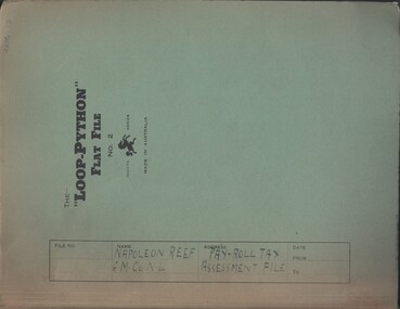
Document - MCCOLL, RANKIN AND STANISTREET COLLECTION: NAPOLEON REEF GOLD MINING CO. N.L, 1941-1950
Documents: Napoleon Reef Gold Mining Co Pay Roll Tax Assessment File, Loop Python Flat File containing Payroll Tax Exemption Certificates and Return of Wages Paid (Annual) from 1941 - 1950, Also a Payroll Tax Refund notification dated 3 March 1944, Markings: File Name written in ink on front cover.organization, business, industrial - mining, mccoll rankin & stanistreet, mining, gold mining, napoleon reef -
 Bendigo Historical Society Inc.
Memorabilia - Miniature Cricket Stumps
Possibly from 17th May 1884 to commemorate North Bendigo Cricket Club winning the Cricket Trophy for that year. From TROVE : A banquet in connection with the above cricket club was celebrated at the Johnson's Reef Hotel last evening. There were about 50 people present. Mr. W. M'Lean, on behalf of the donors of the cricket trophy, presented the handsome claret jug to the president of the North Bendigo Club. Band has J. R C 84 - 13 on back - Possibly J.R (Johnsons Reef) C 84 (Circa 84 - 1884 ) 13 on back possible the number of the player it was given to.3 8cm wooden stick all held by a metal band . The sticks/bales are pointed at the end.J.R. C84 - 13 on backcricket, cricket history, north bendigo cricket club, 1884 -
 Warrnambool and District Historical Society Inc.
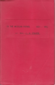
Booklet, On the Western Patrol, Mid 20th century
This is the story told by the Rev. C. Fraser of his two years as a Home Missionary of the Presbyterian Church in the Otway Ranges in 1891-2. The area covered was from Lorne to Peterborough. The booklet includes the names and activities of many settlers of the time and a description of the wreck of the Newfield. This book is of interest to researchers looking for information on the Otway Ranges settlers at the end of the 19th century. It includes names and events and gives an interesting insight into life in the Otway Ranges in the 1890s. This is a small booklet of 44 pages with a red cover and the title printed in black on the front cover. The pages have been stapled together. There are no photographs or illustrations. Front Cover: ‘On the Western Patrol 1891-1892 by Rev. C.A. Fraser’presbyterian church, home missions otway ranges, warrnambool, rev. c. fraser -
 Warrnambool and District Historical Society Inc.
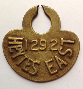
Functional object - Tag, cow Heytesbury East, late 20th century
The Heytesbury Settlement Scheme in the area west of Colac and bordering the Otway Ranges. The Settlement was established in 1960 as a dairying area and was one of the largest post World War Two farming settlements. This cow tag has been broken at the top and detached from the animal.The item is of some interest as coming from the Heytesbuty Settlement. Dairying is of major importance in the Warrnambool area and this extends to the Heytesbury area. These cow tags have now been superseded by more improved technological equipment. This is a brass cow tag. It is semi-circular with a ring top, broken or worn through at the top. ‘1292’ ‘Heytes East’ heytesbury settlement scheme, cow tag -
 City of Moorabbin Historical Society (Operating the Box Cottage Museum)
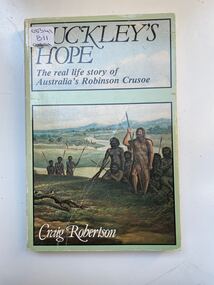
Book, Globe Press Pty. Ltd, Buckley's hope : the story of Australia's wild white man, 1981
A small soft cover book with a blue/green cover,on the front cover is a painting of early Australia with Indigenous Australians hunting with spears alongside them is a European with long unkept hair and a beard dressed in animal skins,on the back cover is text by the author giving a brief outline of the book.buckley, sorrento, robinson crusoe, port phillip, van diemen's land, colonialism, 1840, convicts, indigenous tribes. -
 Stawell Historical Society Inc
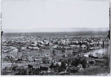
Photograph, View of Stawell from Big Hill April 1874 showing mines centered on north end of Main Street -- 2 Photos
From left Shire Hall Pleasant Creek in distance, Mathers & Franklin, Stawell Coach Factory, Coffee Palace, Christ Church of England Church Hill, Mechanics Institute, Temperance Hotel, Matherson Cross Reef Hotel.Black and White Holtermann photograph of Stawell from Big Hill with mining in foreground. 1874 Site of fire in Main and Street Patrick Street 22 April 1874 visible in centre of photograph.mining, panorama, streetscape -
 Flagstaff Hill Maritime Museum and Village
Bracket, On or before 1889, when the Newfield was built
This bracket was recovered from the wreck of the Newfield. The barque Newfield left Liverpool on 1st June 1892 with a cargo of 1850 tons of fine rock salt for Brisbane. About six weeks later the ship ran into very heavy weather approaching the Australian coast. On 28th August at about 9pm her master, Captain George Scott, observed between the heavy squalls the Cape Otway light on the mainland of Victoria, but due apparently to a navigational error (the chronometers were incorrect), he mistook it for Cape Wickham on King Island, some 40 miles south. He altered course to the north expecting to run through the western entrance of Bass Strait, but instead, at about 1:30am, the ship ran aground about about 100 yards from shore, one mile east of Curdies River. The vessel struck heavily three times before grounding on an inner shoal with six feet of water in the holds. The Newfield remained upright on the reef with sails set for a considerable time as the wind slowly ripped the canvas to shreds and the sea battered the hull to pieces. Seventeen men survived the shipwreck but the captain and eight of his crew perishedFlagstaff Hill’s collection of artefacts from the Newfield is significant for its association with the shipwreck Newfield, which is listed on the Victorian Heritage Registry. The collection is significant because of the relationship between the objects. The Newfield collection is archaeologically significant as the remains of an international cargo ship. The Newfield collection is historically significant for representing aspects of Victoria’s shipping history and its association with the shipwreck.‘L’ bracket, copper, 3 holes on one side, 2 holes on the other1893, shipwrecks, shipwrecked coast, flagstaff hill, flagstaff hill maritime museum, maritime museum, shipwrecked artefact, flagstaff hill maritime village, shipwreck coast, warrnambool, newfield, 1892, 28 august 1892, port campbell, nineteenth century, victorian shipwrecks, barque, norma bracken, peterborough, 29 august 1892, peter ronald, curdies river, bracket -
 Flagstaff Hill Maritime Museum and Village
Functional object - Porthole, Before June 1892, when the Newfield sailed for Brisbane
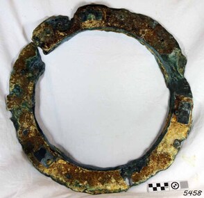
This porthole frame was recovered from the wreck of the Newfield. The barque Newfield left Liverpool on 1st June 1892 with a cargo of 1850 tons of fine rock salt for Brisbane. About six weeks later the ship ran into very heavy weather approaching the Australian coast. On 28th August at about 9pm her master, Captain George Scott, observed between the heavy squalls the Cape Otway light on the mainland of Victoria, but due apparently to a navigational error (the chronometers were incorrect), he mistook it for Cape Wickham on King Island, some 40 miles south. He altered course to the north expecting to run through the western entrance of Bass Strait, but instead, at about 1:30am, the ship ran aground about about 100 yards from shore, one mile east of Curdies River. The vessel struck heavily three times before grounding on an inner shoal with six feet of water in the holds. The Newfield remained upright on the reef with sails set for a considerable time as the wind slowly ripped the canvas to shreds and the sea battered the hull to pieces. Seventeen men survived the shipwreck but the captain and eight of his crew perished.Flagstaff Hill’s collection of artefacts from the Newfield is significant for its association with the shipwreck Newfield, which is listed on the Victorian Heritage Registry. The collection is significant because of the relationship between the objects. The Newfield collection is archaeologically significant as the remains of an international cargo ship. The Newfield collection is historically significant for representing aspects of Victoria’s shipping history and its association with the shipwreck.A porthole frame from the wreck of the Newfield. The porthole and glass are missing. It is encrusted, cracked and eroded. There are 8 retaining bolt holes with the remnants of 7 bolts remaining. On the inside are the remains of the hinge flange and the two release screws. Restored, good condition.warrnambool, shipwrecked coast, flagstaff hill, flagstaff hill maritime museum, maritime museum, shipwreck coast, flagstaff hill maritime village, shipwrecked artefact, 1892, 1893, 28 august 1892, 29 august 1892, barque, curdie's river, newfield, nineteenth century, peter ronald, peterborough, port campbell, porthole, porthole frame, shipwrecks, victorian shipwrecks -
 Flagstaff Hill Maritime Museum and Village
Functional object - Porthole, On or before 1889, when the Newfield was built
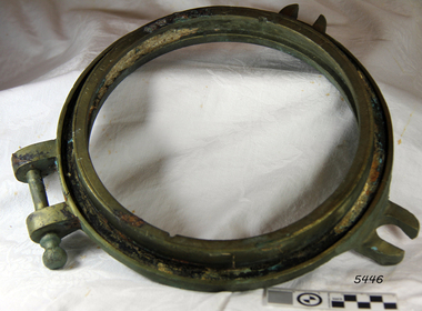
This small porthole was recovered from the wreck of the Newfield. The barque Newfield left Liverpool on 1st June 1892 with a cargo of 1850 tons of fine rock salt for Brisbane. About six weeks later the ship ran into very heavy weather approaching the Australian coast. On 28th August at about 9pm her master, Captain George Scott, observed between the heavy squalls the Cape Otway light on the mainland of Victoria, but due apparently to a navigational error (the chronometers were incorrect), he mistook it for Cape Wickham on King Island, some 40 miles south. He altered course to the north expecting to run through the western entrance of Bass Strait, but instead, at about 1:30am, the ship ran aground about about 100 yards from shore, one mile east of Curdies River. The vessel struck heavily three times before grounding on an inner shoal with six feet of water in the holds. The Newfield remained upright on the reef with sails set for a considerable time as the wind slowly ripped the canvas to shreds and the sea battered the hull to pieces. Seventeen men survived the shipwreck but the captain and eight of his crew perished.Flagstaff Hill’s collection of artefacts from the Newfield is significant for its association with the shipwreck Newfield, which is listed on the Victorian Heritage Registry. The collection is significant because of the relationship between the objects. The Newfield collection is archaeologically significant as the remains of an international cargo ship. The Newfield collection is historically significant for representing aspects of Victoria’s shipping history and its association with the shipwreckSmall porthole frame (inner), from the wreck of the Newfield. Glass missing, brass with 2 screw dogs lugs and one hinge. Restored, good condition.warrnambool, shipwrecked coast, flagstaff hill, flagstaff hill maritime museum, maritime museum, shipwreck coast, flagstaff hill maritime village, shipwrecked artefact, 1892, 1893, 28 august 1892, 29 august 1892, barque, curdie's river, newfield, nineteenth century, peter ronald, peterborough, port campbell, porthole, shipwrecks, victorian shipwrecks -
 The Beechworth Burke Museum
Photograph - Photograph - Reproduction, c1900
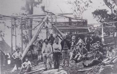
Depicted are a group of men standing in front of a wooden structure. The men wear attire appropriate to the 1920s. This photos is of the shows miners at the Homeward Bound Mine in Hillsborough. The Homeward Bound reef was discovered in 1865 and was worked continuously until 1880. This image is significant as it shows how Victorians worked during the gold rush era. A black and white rectangular photograph depicting 21 separate men, either standing or sitting around a wooden structure. Each man wears the typical attire for gold mining in the 1900s. A horse appears behind a man on the right side of the photograph.The background shows a wooden structure of a mine and the Australian gumtree 7855 /mining, group photo, burke museum, beechworth, photograph, hillsborough, mine, homeward bound mine -
 Bendigo Historical Society Inc.
Document - CHRISTMAS REEF GOLD MINING CO. COLLECTION: LETTER OF INCORPORATION
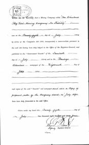
Document certifying that the Christmas Reef Gold Mining Company No Liability was on the 25th day of July 1894, by virtue of the companies Act 1890, incorporated. Copies of notice in Gazette. Signed Deputy Registrar General Edward Daniel ? Also, handwritten note Principal nuggets (sic ) found on Bendigo G. Mackay's History of Bendigo - lists nuggets found in the early 1850's.bendigo, mining, christmas reef gold mining -
Bendigo Historical Society Inc.
Map - MAP: VIRGINIA MINE GARDEN GULLY LINE OF REEF
Map of Virginia Mine on the Garden Gully line of reef, Eaglehawk, transverse section. Shaft, levels and Garden Gully anticlinal axial line drawn. Key shows types of formations - quartz, spurs, sandstone, slate, cleavage, lava. This map forms part of the Geological Survey of Victoria, Structure of Bendigo Goldfield report, No. 47, 1923. H.Herman, late Director of Geological Survey.Geological Survey Victoria, Geological Survey Office, Bendigo.bendigo, gold mining, virgina mine eaglehawk, eaglehawk, bendigo, gold mining, virginia mine, garden gully line of reef. -
 Bendigo Historical Society Inc.
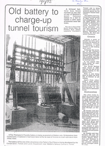
Newspaper - LONG GULLY HISTORY GROUP COLLECTION: 10 HEAD BATTERY
Copy of a newspaper article titled Old battery to charge-up tunnel tourism. Date written on the paper is 11/1/85. The Thompson's Foundry Battery was re-erected in the Parkin's Reef Reserve after being used at Bola Creek near the NSW border. A team of volunteers and a Grant had it moved to Maldon where it was set up and the area made attractive for tourists.bendigo, history, long gully history group, the long gully history group - 10 head battery, thompson's foundry battery, parkin's reef reserve, conservation forests and lands department, carman's tunnel, north british mine, parkins reef, carman's tunnel committee, dr doug kemsley, prospectors' and miners' association of victoria, mr ken garden -
 Bendigo Historical Society Inc.
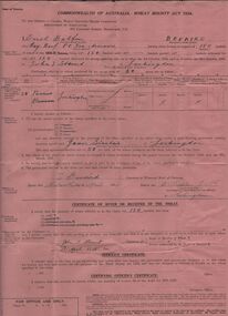
Document - ERROL BOVAIRD COLLECTION: WHEAT BOUNTY CLAIM
The John Bovaird Collection : Commonwealth of Australia Wheat Bounty Act 1934 State of Victoria Claim for Payment. By Errol Balfour Bovaird of May Reef PO via Avonmore. Regarding 150 bushels delivered for sale to John T Stewart of Lockington. Wheat produced on 50 acres : Allotment 25 Parish of Pannoo Bamawm. Dated 13/4/1935. Pink paper.agriculture, farm, wheat crop -
 Bendigo Historical Society Inc.
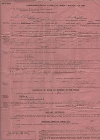
Document - ERROL BOVAIRD COLLECTION: WHEAT BOUNTY CLAIM
The John Bovaird Collection. Commonwealth of Australia Wheat Bounty Act 1934 State of Victoria Claim for Payment. By Errol Balfour Bovaird of May Reef PO via Avonmore. Regarding 96 bushels delivered for sale to R. Anderson of Lockington. Wheat produced on 50 acres : Allotment 25 Parish of Pannoo Bamawm. Dated 13/4/1935. Pink paper.agriculture, farm, wheat crop -
 Bendigo Historical Society Inc.
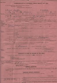
Document - ERROL BOVAIRD COLLECTION: WHEAT BOUNTY CLAIM
The John Bovaird Collection. Commonwealth of Australia Wheat Bounty Act 1934 State of Victoria Claim for Payment. By Errol Balfour Bovaird of May Reef PO via Avonmore. Regarding 96 bushels delivered for sale to R. G. Anderson of Lockington. Wheat produced on 50 acres : Allotment 25 Parish of Pannoo Bamawm. Dated 13/4/1935. Pink paper.agriculture, farm, wheat crop -
 Bendigo Historical Society Inc.
Document - ERROL BOVAIRD COLLECTION: WHEAT BOUNTY CLAIM
The John Bovaird Collection. Commonwealth of Australia Wheat Bounty Act 1934 State of Victoria Claim for Payment. By Errol Balfour Bovaird of May Reef PO via Avonmore. Regarding 96 bushels delivered for sale to Henry Jackson of Lockington. Wheat produced on 50 acres : Allotment 25 Parish of Pannoo Bamawm. Dated 13/4/1935. Pink paper.agriculture, farm, wheat crop -
Bendigo Historical Society Inc.
Document - MINING REPORTS - JOHNSONS REEF EXT'D G M C MINE MANAGER'S REPORT
Handwritten extracts from the Johnsons Reef Ext'd G. M. C. Mine Manager, Wm. Stubbs Report dated Aug. 7th 1888, 12-2-1895 and Aug 2nd 1892. Report mentions an accident caused by the trucker neglecting to fasten the truck in the cage, cost of sinking the shaft and selling a second-hand whip-pole to Mr. Liddle for one pound.document, gold, mining reports, mining reports, johnsons reef ext'd g m c mine manager's report, wm stubbs, j stubbs, the constellation coy, mr liddle -
Bendigo Historical Society Inc.
Book - HISTORIC GUIDE TO BENDIGO
Historic Guide to Bendigo. 5401 has Four(4) loose slips of paper at the front. Maps are in the back.The map of the goldfields shows Streets, Lines of Reef, and Principal shafts. Recommended for tourists, students, prospectors and historians. Produced by the Bendigo Branch of The Royal Historical Society of Victoria, which was compiled from material supplied by members, and edited by H. J. G. Biggs.Produced by the Bendigo Branch of The Royal Historical Society of Victoria, which was compiled from material supplied by members, and edited by H. J. G. Biggs.bendigo, history, city history. the goldfields. -
 Bendigo Historical Society Inc.
Document - BENDIGO - SHEEP RUN TO GOLDEN CITY
Seven pages typewritten documents on the history of Bendigo titled Bendigo - Sheep Run to Golden City. Chapters: Golden Beginnings, Bendigo-The Name, The Founding of a City, Quartz Reefing, Gold Decline, Bendigo-The City, A City for All, A Spectacle of Delights for the Visitor, Bendigo-City of Progress. Authored by Felicity Kingerlee, Assistant Secretary, Royal Historical Society of Victoria, Bendigo Branch.bendigo, history -
Bendigo Historical Society Inc.
Document - NEW CHUM RAILWAY MINE - NOTES ON THE NEW CHUM RAILWAY MINE
Three type d copies of notes on the New Chum Railway Mine on the New Chum Line of Reef. Notes include depth of shaft (4,318 feet), Size of lease, locality, plant - includes poppet legs,winding engine, two engine houses, crushing battery, early history, where the best gold was found, prominence, total gold production and dividends.document, gold, new chum railway mine, new chum railway mine, notes on the new chum railway mine, w d c denovan, mr piper, rourke & henderson's claim, mines dept special edition australian mining standard 1/6/1899, mines dept booklet 'bendigo goldfield' g brown 1936, 'annals of bendigo' mining sections 1890 to 1910, a richardson -
 Bendigo Historical Society Inc.
Document - MCCOLL, RANKIN AND STANISTREET COLLECTION: NAPOLEON REEF GOLD MINING CO. N.L, 1940 - 1952
Document: Napoleon Reef Gold Mining Company Minute Book, Handwritten minutes of meetings of the mine directors from 9 May 1940 - 26 March 1942, Minutes of ordinary general meetings of shareholders 4 August 1942 - 19 December 1952, Minutes signed by A.Mackay (Chairman), final entry on page 102 is a typed resolution relating to voluntary liquidation.organization, business, industrial - mining, mccoll rankin & stanistreet, mining, gold mining, napoleon reef -
 Daylesford & District Historical Society
print of artwork, 1882 comet sighted near Daylesford, circa 1887
A super comet known as the 'Great September Comet' and renowned by some to be the brightest comet ever seen. Visible by the naked eye in the Southern skies in 1882. Depicts visual record of a local sighting by early settlers of a special astronomical event in the Daylesford area in the 1880's.A print of art work depicting a man and woman near their hut in forest clearing, looking up to comet in sky. Rectangular shape, sepia colour and adhered on card. On front bottom; THE COMET of 1882 as seen from Sailors Creek near Daylesford Sept 6 at 4.30am. On back; Donated by O.Bell Musk Vale written in ink. Olive Bell of Bells Reef Road family hist Mathew Bell written in pencil. At bottom written in ink; Seen at 4.30a.m Sept 6 1882astronomy, comets, daylesford, sailors creek, bell, bell family -
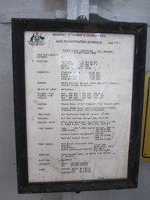 Parks Victoria - Point Hicks Lightstation
Schedule, ‘Aids to Navigation Schedule'
‘Aids to Navigation’ schedule. The schedule, dated 1985, is displayed in a black-painted wooden frame attached to the wall of the lantern room. It is presented on the Commonwealth of Australia letterhead and appears to be typed. The Cape Otway lantern room also retains an ‘Aids to Navigation’ schedule of the same date and type. The Point Hicks schedule has first level contributory significance for its historic value and provenance to the lighthouse.Aids to navigation schedule. Framed in black painted timber. Screwed to wall of lighthouse.Yes