Showing 1134 items
matching survey map
-
 Bendigo Historical Society Inc.
Map - JACK FLYNN COLLECTION: BET BET, 18/08/1931
... at the Department of Lands and Survey, Melbourne. 18.8.31 Map: Parish of Bet ...Map: Parish of Bet Bet, Counties of Gladstone and Talbot . Parish plan.By Authority H.J. Green Govt, Printer. Photo Lithographed at the Department of Lands and Survey, Melbourne. 18.8.31map, gladstone, parish plan, bet bet, counties of gladstone and talbot. -
 Bendigo Historical Society Inc.
Map - JACK FLYNN COLLECTION: KARA KARA, 1932
... Inc. History House 11 Mackenzie Street Bendigo goldfields MAP ...Map: County of Kara Kara, map sheet showing the whole of the County of Kara Kara and all of the Parishes within. Scale 2 miles to 1 inch.By Authority: W.M. Houston, Government Printer Melbourne. Department of Lands and Survey, Melbourne, 1958map, kara kara, county, kara kara -
 Bendigo Historical Society Inc.
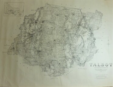
Map - JACK FLYNN COLLECTION: TALBOT, 1937
... Inc. History House 11 Mackenzie Street Bendigo goldfields MAP ...Map: County of Talbot, map sheet showing the whole of the County of Talbot and all of the Parishes within. Scale 2 Miles to 1 inch.By Authority: A.C. Brooks, Government Printer, Melbourne. Department of Lands and Survey Melbourne. 1959map, talbot, county, talbot -
 Bendigo Historical Society Inc.
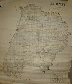
Map - JACK FLYNN COLLECTION: RODNEY, Revised in 1935
Map: County of Rodney, map sheet showing the whole of the County of Rodney and all of the Parishes within.Drawn at the Department of Lands and Survey, Melbourne. Revised to 1935map, rodney, parish plan, rodney -
 Bendigo Historical Society Inc.
Map - JACK FLYNN COLLECTION: HUNTLY, August 1954
Map: Parish of Huntly, County of Bendigo. Parish plan.By Authority W.M. Houston, Government Printer. Drawn and Reproduced at the Dept, of Lands and Survey, Melbourne, Victoria. August 1954.map, bendigo, parish plan, huntly -
 Bendigo Historical Society Inc.
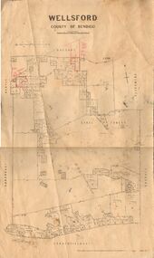
Map - JACK FLYNN COLLECTION: WELLSFORD, 2/11/1914
Map: Parish of Wellsford, County of Bendigo. Parish plan.Photo-Lithographed at the Department of Lands and Survey Melbourne By H.J. Butson. 2-.11.14map, bendigo, parish plan, wellsford -
 Bendigo Historical Society Inc.
Map - JACK FLYNN COLLECTION: GOORNONG, August 1953
Map: Township of Goornong, Parish of Goornong, County of Bendigo. Parish plan.By Authority W.M. Houston. Government Printer. Drawn and Reproduced at the Dept., of Lands and Survey, Melbourne, Victoria. August 1953map, bendigo, township, goornong -
 Bendigo Historical Society Inc.
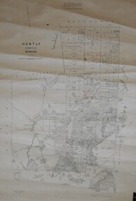
Map - JACK FLYNN COLLECTION: HUNTLY, 12.03.1932
... -Lithographed at the Dept., of Lands and Survey, Melbourne. 12.3.32 Map ...Map: Township of Huntly, Parish of Huntly , County of Bendigo. Parish plan. Western and South Riding Division on Main St. (Main Northern Highway) - written in ink below name of map.BY Authority H.J. Green. Photo-Lithographed at the Dept., of Lands and Survey, Melbourne. 12.3.32map, bendigo, township, huntly -
 Bendigo Historical Society Inc.
Map - JACK FLYNN COLLECTION: COUNTY OF GLADSTONE, 1934
Map: County of Gladstone, map sheet showing the whole of the County and the Parishes within. Scale 2 Miles to 1 inch.Engraved at the Department of Lands and Survey Melbourne. 1958. By Authority of W.M. Houston, Government Printermap, gladstone, parish plan, gladstone -
 Bendigo Historical Society Inc.
Map - JACK FLYNN COLLECTION: YARRAYNE, 6/01/1932
... Inc. History House 11 Mackenzie Street Bendigo goldfields MAP ...Map: Parish of Yarrayne, County of Bendigo. Parish plan.By Authority, H.J. Green, Govt., Printer. Photo-Lithographed at the Department of Lands and Survey, Melbourne. 5.1.32.map, bendigo, parish plan, yarrayne -
 Bendigo Historical Society Inc.
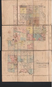
Map - JACK FLYNN COLLECTION: WOODSTOCK, 27/03/75
Map: Parish of Woodstock , County of Bendigo. Parish plan.Photo-Lithographed at the Department of Lands and Survey Melbourne by J. Noone. 27.3.79map, bendigo, parish plan, woodstock -
 Bendigo Historical Society Inc.
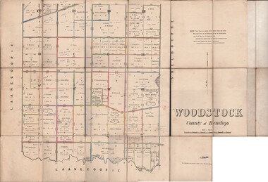
Map - JACK FLYNN COLLECTION: WOODSTOCK, 4/07/1935
... Inc. History House 11 Mackenzie Street Bendigo goldfields MAP ...Map: Parish of Woodstock, County of Bendigo. Parish plan.By Authority H.J. Green. Govt Printer. Drawn and Reproduced at the Dept of Lands and Survey, Melbourne Victoria. 4.7.35map, bendigo, parish plan, woodstock -
 Bendigo Historical Society Inc.
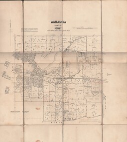
Map - JACK FLYNN COLLECTION: WARANGA, 1959
... and survey. Melbourne 1959. Map: Parish of Waranga, County of Rodney ...Map: Parish of Waranga, County of Rodney. Parish plan.By Authority. A.C. Brooks. Government Printer Melbourne. Drawn and Reproduced at the Department of lands and survey. Melbourne 1959.map, rodney, parish plan, waranga -
 Bendigo Historical Society Inc.
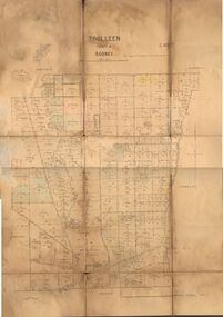
Map - JACK FLYNN COLLECTION: TOOLLEEN, 25/05.1926
Map: Parish of Toolleen, County of Rodney. Parish plan.By Authority, H.J. Green. Govt., Printer. Photo-Lithographed at the Department of Lands and Survey Melbourne. W. J. Butson 25.5.26.map, rodney, parish plan, toolleen -
 Bendigo Historical Society Inc.
Map - LOCAL AREA PLANS, See above
... dated December 27 1872, Road survey of Toolleen Map LOCAL AREA ...Map: Compilation of maps: Village of Redcastle dated april 14 1861, Township of Yarraberb dated 14 July 1874, Hamlet of White Hills dated December 27 1872, Road survey of Toolleenmap, parish plan, redcastle, yarraberb, white hills, toolleen -
Bendigo Historical Society Inc.
Document - MAP INDEX SHEETS, No dates on item
Map index sheets for Military survey Inch to the Mile scale maps.Covering Victoria , Tasmania, Northern Territory,Queensland and New South Wales. There are Four sheets numbered 9156 a, b , c and d. These are photocopied sheets, NOT originalsdocument, map index sheets, inch to the mile index sheets -
 Bendigo Historical Society Inc.
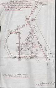
Plan - MCCOLL, RANKIN AND STANISTREET COLLECTION: PLAN OF SURVEY OF DAM SITE, 1941
McColl Rankin & Stanistreet, Plan of Survey of Dam site, Part of Crown Allotment 98 Section C, City of Bendigo, Parish of Sandhurst, County of Bendigo. Signed by Garnet G Birch 1 Feb 1941. 33.5 x 43. Attached is a Copy of Field notes, Dam Site in Crown Allotment 198 Sec. City of Bendigo, Parish of Sandhurst. True Meridian, County of Bendigo, Area 0A 1R 16P. Signed Garnet G Birch, 1/2/1941. Drawn in red and black pen. 20.8 x 33. Both maps are for Deborah Extended Gold Mining Co. No Liabilityorganization, mining, deborah extended gold mining co nl, mccoll rankin & stanistreet, plan of survey of dam site -
Bendigo Historical Society Inc.
Map - MANDURANG, 8/10/1887
Parish of Mandurang, County of Bendigo. Traced from a re-survey of the Parish of Mandurang by Mr. Geo. Black 8/10.1887 ( number 158 in Map Cupboard 1)map, bendigo, parish plan, mandurang, re-survey, couny of bendigo -
Bendigo Historical Society Inc.
Map - MAP PORTION OF BENDIGO GOLDFIELD, Circa 1912
Map: Portion of Bendigo Goldfield showing Sheepshead, Deborah, Garden Gully, Paddy's Gully and Derby lines of reef. Showing statistical records of all the Companies on these lines. Issued by Wood and McNair, Sharebrokers, Bendigo and Eaglehawk. The map illustrates the main lines of reef as they appeared with mines and details of their calls and dividends as well as gold produced. Drawn by mining surveyor and geologist William Henry Cundy, who trained and worked for the Tasmanian Mines Department until 1893, when he moved and settled in Bendigo. Cundy was responsible for the surveying of the southern end of the field of Diamond Hill and beyond.topic, mining, companies, bendigo goldfield, sheepshead , deborah, garden gully, paddy's gully derby, wood and mcnair -
Bendigo Historical Society Inc.
Map - VICTORIA, Circa 1926
Map: Map showing Counties, including Railway lines and Geographic features. Compiled and engraved at the Department of Lands and Survey Melbourne, Revised October 1926 ( number 184 in Map Cupboard 1)map, victoria, counties, counties of victoria, geographic features -
Bendigo Historical Society Inc.
Map - VICTORIA HILL AREA, May 1971
Map: Bendigo Historical Society feature plan. There are 3 of these plans, one is without feature names and one has several places highlighted in pencil. Compiled by AHQ Survey Regiment, CMF Increment ( number 181 in Map Cupboard 1)map, bendigo, mining plan, victoria hill, bendigo historical society -
 Monbulk RSL Sub Branch
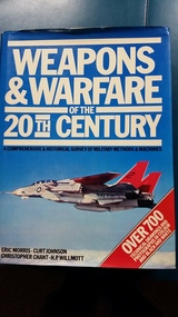
book, Eric Morris, Curt Johnson, Christopher Chant, H P Willmott, Weapons and warfare of the twentieth century, 1975
A panoramic survey of the fighting man and his weapons in the twentieth centuryIndex, ill, maps, p.475.non-fictionA panoramic survey of the fighting man and his weapons in the twentieth centurymilitary weapons - history, air warfare - history -
 Bay Steamers Maritime Museum
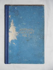
Book, Eyre and Spotiswoode, Australian Directory Volume 1, 1907
... -fiction Australia hydrography charts survey navigation anchorage ...Very significant part of Victorian maritime heritageLight blue cloth hard cover book of 890 pagesInside front cover, handwritten in black calligraphy pen "Hartley F Watson / presented by Capt. Glossop [?] R.N. 1919 / Garden Island, Sydney NSW" Also inside front cover handwritten in blue biro "To MICHAEL WOOD TOPSL SCHOONER 'ALMA DOEPEL' / with COMPLIMENTS HARTLEY F. (BILL) WATSON / c/o R.Y.C.V W'TOWN VIC"non-fiction, australia, hydrography, charts, survey, navigation, anchorage, maps, coast, maritime, marine -
 Bendigo Historical Society Inc.
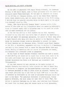
Document - MAJOR MITCHELL AND MOUNT ALEXANDER
Typed notes mentioning the naming of Mount Alexander, Coliban, Campaspe and who named them. Also the origins of the names.document, major mitchell and mount alexander, tommy-came-last, the major mitchell tourist trail, major general john byng, phillip of macedonia, alexander the great, henty s, surveyor davidson, alexander mollison, george augustus robinson, william morton, mr charles hotson ebden, john randell, public library of melbourne, les blake, governor burke, phillip parker king, crown solicitor henry field gurner, arthur phillip, hume, australia felix expedition, l blake, place names of victoria, g brenmer, booklet for secondary schools, m cannon, historical records of victoria vol 1, j h l cumpston, thomas mitchell surveyor general and explorer, h f gurner, chronicle of port phillip, t l mitchell, three expeditions into the interior of eastern australia, a f mollison, an overlanding diary, w l morton, adventures of a pioneer, m s 5188, itinerary from the journal of the exploring expedition returning from portland bay, m s 5189, mitchell's 1837 map, j o randell, pastoral settlement in northern victoria vol 1, pastoral settlement in northern victoria vol 2, records of the victorian archaeological survey number 5, journals of george augustus robinson, t c sargent, some peninsular names in australia felix, w h wells, a geographical dictionary or gazetteer of the australian colonies -
Moorabbin Air Museum
Map (item) - Map - Puckapunyal Range Area Victoria
Military Survey 1:25,000 Zone 7 First Edition -
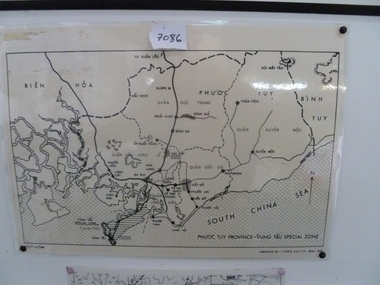 National Vietnam Veterans Museum (NVVM)
Map, Map of Phuoc Tuy Province - Vung Tau Special Zone, 1/05/1968 12:00:00 AM
... of Phuoc Tuy Province - Vung Tau Special Zone Map Map Topo Survey ...Laminated map of Phuoc Tuy Province - Vung Tau special zone. Oulne of hamlets and military bases.AFV/F7-12/1188map, vung tau, 1 atf, 1 alsg -
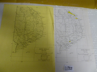 National Vietnam Veterans Museum (NVVM)
Map, 1983 (exact)
Two maps of South Vietnam dated 1954-1975. One on plain paper, one on yellow papermaps, south vietnam -
 St Kilda Historical Society
Photograph - Photo map, 28/01/1951
One of a series of photo-maps produced for the Department of Crown Lands and Survey (1857-1983). For correlation with a current map, and access to other historical photo maps of Victoria, see the Historic Photo-Maps Index published by the Department of Environment, Land, Water and Planning at https://services.land.vic.gov.au/DELWPmaps/historical-photomaps/Black and white aerial photograph1424-45 SECRET 534 Run 18 Lens 12" Melbourne Metropolitan 12150 28.1.51 M639albert park, st kilda junction, st kilda pier, catani gardens, st kilda, prahran, albert park lake, 1951, middle park, st kilda beach, windsor -
 St Kilda Historical Society
Photograph - Photo map, 17/01/1951
One of a series of photo-maps produced for the Department of Crown Lands and Survey (1857-1983). For correlation with a current map, and access to other historical photo maps of Victoria, see the Historic Photo-Maps Index published by the Department of Environment, Land, Water and Planning at https://services.land.vic.gov.au/DELWPmaps/historical-photomaps/Black and white aerial photograph1414-21 538 Run 19 Lens 12" Melbourne Metropolitan 12150 17.1.51 M586st kilda, st kilda botanical gardens, peanut farm, elwood, 1951, point ormond, elwood canal, st kilda beach -
 St Kilda Historical Society
Photograph - Photo map, 28/01/1951
One of a series of photo-maps produced for the Department of Crown Lands and Survey (1857-1983). For correlation with a current map, and access to other historical photo maps of Victoria, see the Historic Photo-Maps Index published by the Department of Environment, Land, Water and Planning at https://services.land.vic.gov.au/DELWPmaps/historical-photomaps/Black and white aerial photograph1424-118 534 Run 20 Lens 12" Melbourne Metropolitan 12150 18.1.51M639elwood, point ormond, elwood park, elsternwick park, elwood beach, 1951