Showing 4549 items matching "the avenue"
-
 Camberwell Historical Society
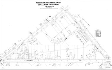
Map (Item) - MMBW map, Melbourne and Metropolitan Board of Works, Melbourne and Metropolitan Board of Works - Shire of Boroondara and Camberwell - Detail Plan no. 1851, July 1904
Lithographer JEM, exd. JWD, July 1904, no. 81, 40P. 15W.melbourne and metropolitan board of works, map, camberwell, cartography -
 Ringwood and District Historical Society
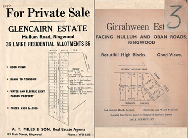
Document - Folder, Land Sale Advertisement, Glencairn Estate and Girrahween Estate, Ringwood - circa 1950s
Single sided advertisement for private sale of residential allotments - undated, circa 1950s.Subdivisions include Mullum Mullum Road,Glen Cairn Avenue (Glencairn), Oban Road, and Norman Avenue (later Hugh Street). Agent - A.T. Miles & Son, 175 Main Street, Ringwood, Phone WU 6215. -
 Kew Historical Society Inc
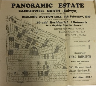
Plan - Subdivision Plan, Panoramic Estate, Camberwell North (Balwyn), 1939, 1939
Subdivision plan advertised as the Panoramic Estate, Balwyn, showing lots for sale in the following streets: Bulleen Road, Macedon Avenue, The Moor, Sunburst Avenue, Doncaster Road, Fortuna Avenue, Longview Road, The Nook, and Touring Avenue.Single page subdivision plan of the Panoramic Estate in Camberwell North (Balwyn); offered for sale in 1939Nilsubdivision plans - balwyn (vic), panoramic estate - camberwell north - balwyn (vic) -
 Hymettus Cottage & Garden Ballarat
Photograph, Nathalia Avenue of Honour, 2006
Photograph of the Nathalia WWI Avenue of Honour taken in 2006 by avenue researcher Michael Taffe. The Nathalia avenue consists of Australian native trees known as Kurrajongs. This photograph forms part of a large collection of images of Avenues of Honour at Hymettus, Ballarat from Michael Taffe's twenty-five years of research into the avenues leading to his PhD ' First World War Avenues of Honour: Social History through the Landscape.'. nathalia, avenue of honour, ballarat, phd, michael taffe, social history, landscape, kurrajongs, -
 Vision Australia
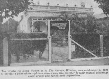
Photograph - Image, Women's Hostel (Egremont) in Windsor newspaper cutting
The AFB were aware that accommodation options for blind people were limited and sought to open a hostel to assist with this.The first hostel opened in Lara Street, South Yarra but could not meet demand. In 1926, a suitable property 'Egremont' at 54 The Avenue, Windsor, came on the market. The price was £2650. Lack of funds to purchase seemed an insurmountable barrier. With assistance from the Trustees of the Edward Wilson Estate and the Felton Bequest a deposit of £650 was raised. In a huge step of faith the Committee took out a mortgage of £2000. The interest on the mortgage and its repayments weighed heavily on the Committee. The Avenue, as 'Egremont' was commonly termed, was also a seven roomed house. Mr Paterson and the Architect, Mr Parkes of Oakley and Parkes, immediately began planning an extension, fourteen single bedrooms were added. They were filled from the Waiting List. A Windsor Auxiliary was formed and worked to reduce the mortgage of £2000. An active programme of dances, card evenings, theatre nights and the like took place under the leadership of Mrs. Robertson. The Auxiliary also took an interest in the boarders, arranging entertainment and social activity. £1500. was still owed in 1930. Living side by side is no easy task for a group of people, and the Hostel meeting minute books are filled with stories of disputes over wireless sets, telephones, hot water bottles and wardrobes. In 1958, with rising costs and the growth of aged care centres, the Hostel was closed and the house sold to a succession of private buyers. In 2016 it still stands and has been refurbished as a guest house.B/W copy of newspaper photographThe hostel for blind women at 54 The Avenue, Windsor was established in 1926 to provide a place where sightless women may live together to their mutual advantage under proper and sympathetic supervision. The Windsor Hostel was sold in 1958. This building still stands today and has been refurbished.egremont, blind womens hostel, tilly aston -
 Southern Sherbrooke Historical Society Inc.
Information folder - Lysterfield Avenue Of Honour
Folder containing items pertaining to Lysterfield Avenue Of Honour. Contents: -typescript, Details of servicemen for whom trees were planted in the Lysterfield Avenue of Honour, 1919 -letter, Heather Ronald to Edmund Williams, re. Lysterfield Avenue of Honour, dated 31st May 1994 -Shire of Sherbrooke Council meeting agenda item, 1st February 1994, inc. 2-page summary, letter E. Williams to Shire dated 13th October 1993, hand-drawn map of area, letter E. Williams to Shire dated 10th September 1993, letter E. Williams to Shire dated 24th June 1993, copy of page from Rowville-Lysterfield Community News. -Program of Events for dedication of Avenue of Honour, 25th February 1995, Knox Historical Society. -Invitation to dedication of Avenue of Honour from Knox HS to Susan Heywood-Downard and members of Southern Sherbrooke Historical Society -
Kew Historical Society Inc
Plan - Camberwell Panorama Estate, 1923
Subdivision plans and real estate flyers/brochures reveal a number of aspects of urban development and history. The Kew Historical Society's collection of these plans, as well as advertisements extracted from magazines, cover key aspects of community development and architectural history of Kew and Kew Eat as well as surrounding suburbs. While most of the plans in the collection were gifted to the Society by the former City of Kew, a number of other plans and advertisements have been donated by individuals, of which this is an example.Promotional brochure for the Camberwell Panorama Estate. The four page bifold handout advertises 216 home sites bounded by Bulleen Road, The Nook, Fortuna Avenue, and Doncaster Road. Other streets in the subdivision include: Sunburst Avenue, The Moor, and Macedon Avenue. The brochure has been damaged at some time in the past and so masking tape obscures the tram on page 1. Page 2 includes the plan of the subdivision, page 3 information about the site and a locality plan, while page 4 includes photographs and terms of sale. subdivision plans -- balwyn north (vic.), camberwell panorama estate -
 Ringwood and District Historical Society
Photographs, 1979-80 MMBW pipe line project at Hubbard Reserve, North Ringwood � Work on boring mole pit
Part of a 43-photo record of the MMBW�s engineering feat in drilling a 12 inch pipe line up to 40 feet deep through rock hardened by volcanic action associated with geological fault that occurs along the line. The work took place from October 1979 to May 1980 on the southern boundary of Hubbard Reserve, North Ringwood. The collection was presented to the Ringwood Historical Research Group by J Clarke on 9th June 1980.E560 N22Jan 1980 A43 Work on mole boring pit in 39 Burlock Avenue backyard -
Tatura Irrigation & Wartime Camps Museum
Photograph - original, Groom and Beckwith Garage, c 1920's
Original photograph of Groom and Beckwith Garage, Hogan Street, Tatura. Harry Beckwith 3rd from left.Black and white photograph of group of 6 men outside garage.on back: donated by Mrs Beckwith, Alexander Avenue, Tatura. 1986. Football scores and other numbersharry beckwith, groom and beckwith garage -
 Greensborough Historical Society
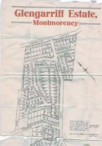
Map, Glengarriff Estate Montmorency, 1938c
Estate Agent's plan of Glengarriff Estate, Montmorency, covering LPs 11334 and 11451. Bordered by Sherbourne Avenue, Calrossie Avenue, Montmorency Station and Price AvenueColour photocopy of subdivision map, on two A3 sheets glengarriff estate montmorency, sherbourne avenue montmorency, calrossie avenue montmorency, price avenue montmorency, montmorency station -
 Emerald Museum & Nobelius Heritage Park
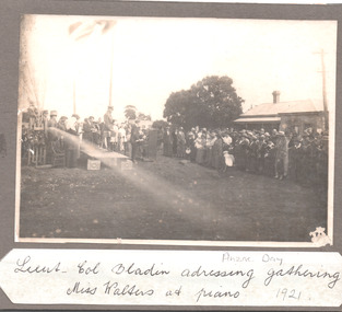
Mounted Photograph, 25/4/1921
The object is historically and socially significant as it shows the opening of Heroes Avenue (Avenue of Honor) three years after the end of Word War I. The trees planted in the Avenue came from the Nobelius Nursery.Photograph mounted on card of the opening of Heroes Avenue, Emerald on ANZAC Day 1921. Showing Lieutenant-Colonel Bladin addressing the gathering.Lieu-Col Bladin adressing gathering Miss Waters at piano. ANZAC Day 1921anzac, heroes avenue, avenue of honor, emerald -
 Ringwood and District Historical Society
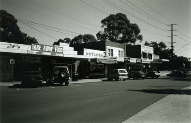
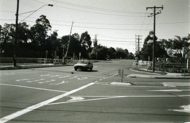
Photograph-B&W, Joan Walker, East Ringwood 2000-Railway Avenue looking East to the junction of Victoria Street, 2000
... East Ringwood 2000-Railway Avenue looking East to the ...East Ringwood 2000-Railway Avenue looking East to the junction of Victoria Street- B&W Photo from Album 6501 -
 Ringwood and District Historical Society
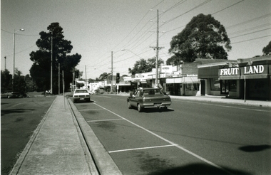
Photograph-B&W, Joan Walker, East Ringwood 2000- Railway Avenue looking West opposite the Railway Station, 2000
... the Railway Station ...East Ringwood 2000- Railway Avenue looking West opposite the Railway Station- B&W Photo from Album 6501 -
 Ringwood and District Historical Society
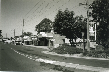
Photograph-B&W, Joan Walker, East Ringwood 2000-Railway Avenue looking East from Laurence Grove, 2000
East Ringwood 2000-Railway Avenue looking East from Laurence Grove- B&W Photo from Album 6501 -
 Ringwood and District Historical Society
Photograph-B&W, Joan Walker, East Ringwood 2000-Railway Avenue looking East from Laurence Grove, 2000
East Ringwood 2000-Railway Avenue looking East from Laurence Grove- B&W Photo from Album 6501 -
 Ringwood and District Historical Society
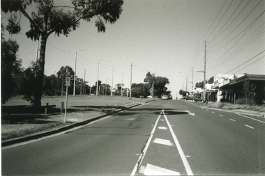
Photograph-B&W, Joan Walker, East Ringwood 2000-Railway Avenue Looking East from Dublin Road, 2000
East Ringwood 2000-Railway Avenue Looking East from Dublin Road- B&W Photo from Album 6501 -
 Ringwood and District Historical Society
Photograph-B&W, Joan Walker, East Ringwood 2000-Railway Crossing and the corner of Dublin Road & Railway Avenue, 2000
East Ringwood 2000-Railway Crossing and the corner of Dublin Road & Railway Avenue- B&W Photo from Album 6501 -
 Victorian Interpretive Projects Inc.
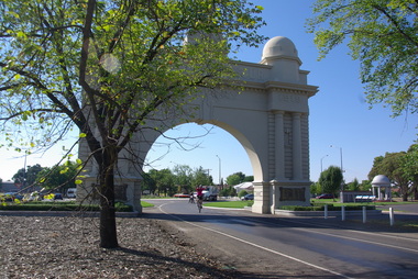
Photograph - Digital, Clare Gervasoni, Samuel Johnson and the 'Love Your Sister' team at the Ballarat Arch of Victory, 16/02/2013
Samuel Johnson is riding around Australia on a unicycle in an attempt to break a world record and raise money for the Garvan Institute (breakthrough medical research) . (www.loveyoursister.org) The Ballarat Courier (18/02/2013) reported: "Actor Samuel Johnson was humbled by the turnout and support in Ballarat for his epic unicycle ride about Australia. After an emotional farewell with sister Connie, who is terminally ill with cancer, Johnson reached Ballarat on day two of his Love Your Sister Ride – an attempt to break the Guinness World Record for the most distance travelled on a unicycle (15,000 kilometres), raise a million dollars for breast cancer research and spread the word for early detection."A unicylist in pink shirt travels under the Ballarat Arch of Victory at the entry to the Ballarat Avenue of Honour. The unicyclist is actor Samuel Johnson.ballarat avenue of honour, ballarat arch of victory, samuel johnson, love your sister, unicycle, cycle -
 Buninyong & District Historical Society
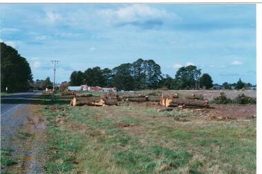
Photograph - Original Photograph, Mr. C.J. Brooks, Main street of Yendon from the West showing felled pine trees, September 1995
Social, historicalExample of the felling of trees for power company in the late twentieth centuryColour photo, of the Western outskirts of the township of Yendon showing 8-10 felled pine trees from the southern side of avenueyendon, moorabool shire, streetscape, felled pinetrees, powercor -
 Robin Boyd Foundation
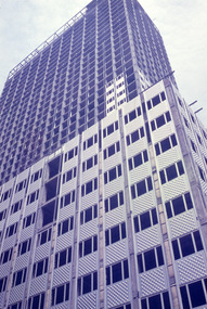
Slide, Robin Boyd, 1956-1957
Robin Boyd developed a close friendship with the founder of the Bauhaus in Weimar Germany, Walter Gropius, who had moved to the USA in the 1930s. Through this connection, Boyd was invited to be the Massachusetts Institute of Technology (MIT) Bemis Professor at the School in the North American academic year 1956-7. Robin and Patricia Boyd, with their youngest daughter Suzy, were based in Cambridge, Massachusetts for the year. Boyd gave some lectures at MIT and he was also invited to give lectures at many other universities, allowing him to travel widely within the USA, especially on the East Coast. This gave him the opportunity to meet architects like Frank Lloyd Wright, Eero Saarinen, Paul Rudolph and many others, and visit the offices of Skidmore, Owings and Merrill, and places like Taliesin and the General Motors Technical Center Detroit. On the way home, the Boyds visited London, Berlin, Paris and Le Corbusier’s Ronchamp Chapel in France.Colour slide in a mount. 660 Fifth Avenue, New York City, New York, USA, 1957. (Architects: Carson and Lundin.)Made in USA / Patented / 04819 / B (Handwritten) / Encircled 15 (Handwritten) / Encircled 21 (Handwritten)mit bemis professorship, mit, robin boyd, slide -
Whitehorse Historical Society Inc.
Document, Certificate of Title, 1924
Certificate of Title vo. 4824 fol. 964713, 19 February 1924, 5 Tyrrell Avenue Blackburn, owned by Samuel LuscombeCertificate of Title vo. 4824 fol. 964713, 19 February 1924, 5 Tyrrell Avenue Blackburn, owned by Samuel LuscombeCertificate of Title vo. 4824 fol. 964713, 19 February 1924, 5 Tyrrell Avenue Blackburn, owned by Samuel Luscombetyrrell avenue blackburn, no.5, luscombe, samuel, shire of blackburn and mitcham -
 Whitehorse Historical Society Inc.
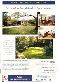
Document, 26 Penllyne Avenue, Vermont, 1/06/1998 12:00:00 AM
Auction brochure 26 Penllyne Avenue,Auction brochure 26 Penllyne Avenue, Vermont. Large allotment, brick veneer home auction June 1998. Built 1954.Auction brochure 26 Penllyne Avenue,auctions, penllyne avenue, vermont, no 26, cody first national real estate -
 Whitehorse Historical Society Inc.
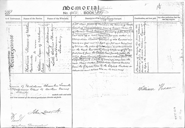
Legal record - Land Title, Land Memorial, 1860
Land Memorial No 963, Book 377, relating to transfer of land in Metropolitan Avenue, Nunawading from William Horan to William Loganhoran, william, logan, metropolitan avenue, nunawading, land sales -
 Whitehorse Historical Society Inc.
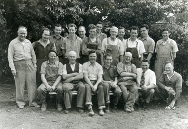
Photograph, Staff Swifts Foundry
Joe Swift made and donated the following items to the Mitcham Sub-Branch of the RSL.|1. RSL Badge outside the entrance doors from the main car park.|2. Legacy Badge inside the above doors.|3. Sword mounted on the East wall of the main hall.|It is thought that Swift's Foundry manufactured some items for Canberra War Museum and the above may have been replicas.Black and white photo of Staff at Swifts Foundry, Carween Avenue, Mitcham. Swifts made Commemorative Plaque for opening of Schwerkolt Cottage.swifts foundry, carween avenue, mitcham, cook, molly -
 Whitehorse Historical Society Inc.
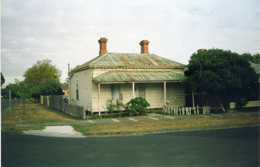
Photograph, 38 Haines St., Mitcham, 1/06/2002 12:00:00 AM
Coloured photo of House at 38 Haines St., Mitcham (corner of Victoria Avenue)in the process of being renovated. An example of an early residence.haines street., mitcham, no.38 -
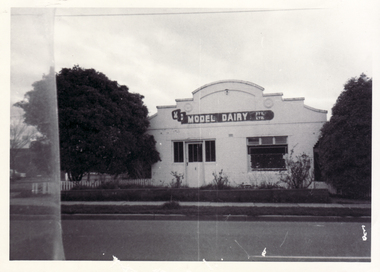 Whitehorse Historical Society Inc.
Photograph, Davin's Dairy, C.1977
Black and white photo of Davin's Dairy, corner Mitcham Road and Victoria Avenue, Mitcham. Dairy later bought by Model Dairy.davin's dairy, model dairy -
Whitehorse Historical Society Inc.
Document - Correspondence, Roads, 1937
Draft and copies of notice to move resolution for notice to be served for liability for cost of road construction for Vernal Avenue, Mitcham, March 1937.vernal avenue, mitcham, shire of blackburn and mitcham, road construction and maintenance -
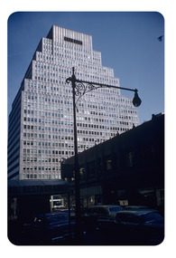 Robin Boyd Foundation
Slide, Robin Boyd, 1956-1957
Robin Boyd developed a close friendship with the founder of the Bauhaus in Weimar Germany, Walter Gropius, who had moved to the USA in the 1930s. Through this connection, Boyd was invited to be the Massachusetts Institute of Technology (MIT) Bemis Professor at the School in the North American academic year 1956-7. Robin and Patricia Boyd, with their youngest daughter Suzy, were based in Cambridge, Massachusetts for the year. Boyd gave some lectures at MIT and he was also invited to give lectures at many other universities, allowing him to travel widely within the USA, especially on the East Coast. This gave him the opportunity to meet architects like Frank Lloyd Wright, Eero Saarinen, Paul Rudolph and many others, and visit the offices of Skidmore, Owings and Merrill, and places like Taliesin and the General Motors Technical Center Detroit. On the way home, the Boyds visited London, Berlin, Paris and Le Corbusier’s Ronchamp Chapel in France.Colour slide in a mount. Colour slide in a mount. 99 Park Avenue, New York, USA (Architect: Emery Roth and Sons)Made in USA/ 04819/ D (Handwritten)/ Encircled 6 (Handwritten)mit bemis professorship, mit, robin boyd, slide -
![Terrace Houses [Doona Avenue]](/media/collectors/550653872162f11fb04854aa/items/5801bf73d0cdd103d038246a/item-media/5801bfe1d0cdd103d0386581/item-fit-380x285.jpg) Kew Historical Society Inc
Kew Historical Society IncWork on paper, Joy Stewart, Terrace Houses [Doona Avenue], c.1978
Sydney Joy (joy) Stewart (1925-2018) was a founding member of the Kew Historical Society, and during the 1970s its secretary. During her residence in Kew, she completed numerous property illustrations on commission. These ranged from preliminary sketches, including architectural details to finished pen & ink and wash illustrations on paper. On moving to Queensland, Joy Stewart donated the remaining property illustrations in her possession to the Kew Historical Society. In 1987-88, she fulfilled a commission by the Society of designs for a series of embroideries completed by residents during the Australian Bicentennial commemorations.Sydney Joy (Joy) Stewart was born in Melbourne 1925. She studied at Swinburne Technical College Art School from 1941-1945, then the National Gallery Art School 1946-1948. Her career included employment positions as a display artist, designer/painter, gallery assistant, and art teacher. Joy relocated to Cairns in 1981. Solo exhibitions in Melbourne and Cairns, including 'Done By Me' at Cairns Regional Gallery in 1999. Group exhibitions at Cairns Regional Gallery, 'The Fish John West Regrets, 1993' and 'Facets of Life' 1994. Joy Stewart died in Cairns in 2018.Two preliminary sketches of the terrace houses at 7 and 9 Doona Avenue, Kew. See 1980.0024 for a more complete monochrome drawing. Signed: "JStewart".joy stewart, doona avenue (kew) -
Canterbury History Group
Photograph - Eleanor and Rosemary Golding, 1944
Eleanor and Rosemary Golding aged 13 and 8 years in the garden of 12 Hopetoun Avenue, Canterbury, 1944. black and white photograph.canterbury, hopetoun avenue, golding family, guide groups