Showing 15145 items matching "view"
-
 Eltham District Historical Society Inc
Photograph, View from lounge room looking towards Pitt Street and Wattle Grove, 218 Pitt Street, Eltham, c.1985, 1985c
House was rented by Kim Tarpey between October 1983 and June 1985. It was one of the buildings originally part of Birds Orchard. Harold Bird was her landlord, a retired primary school teacher who, when she knew him was driving the mobile library bus. Her partner had him as a teacher at Montmorency Primary in grade 4. The house was next door to what is now a bushland reserve near the Pauline Toner Reserve. It was on the corner of Pitt and Arthur St - the driveway was near the roundabout and went off to the right of the driveway that now belongings to 220 Pitt street and which was bushland at the time. It was sold in 1985 and consequently demolished, a large house has replaced it. It was situated approximately where the front door of No. 218 is nowadays with the facade roughly in line with the now garage wall to the left of this front door.Digital file only - scanned from personal photo album on loan218 pitt street, eltham, houses, birds orchard, harold bird, kim tarpey, eucalyptus road -
 Eltham District Historical Society Inc
Photograph, View from back fence looking towards Pitt Street and Wattle Grove, 218 Pitt Street, Eltham, c.1985, 1985c
House was rented by Kim Tarpey between October 1983 and June 1985. It was one of the buildings originally part of Birds Orchard. Harold Bird was her landlord, a retired primary school teacher who, when she knew him was driving the mobile library bus. Her partner had him as a teacher at Montmorency Primary in grade 4. The house was next door to what is now a bushland reserve near the Pauline Toner Reserve. It was on the corner of Pitt and Arthur St - the driveway was near the roundabout and went off to the right of the driveway that now belongings to 220 Pitt street and which was bushland at the time. It was sold in 1985 and consequently demolished, a large house has replaced it. It was situated approximately where the front door of No. 218 is nowadays with the facade roughly in line with the now garage wall to the left of this front door.Digital file only - scanned from personal photo album on loan218 pitt street, eltham, houses, birds orchard, harold bird, kim tarpey, eucalyptus road -
 Eltham District Historical Society Inc
Photograph, View from back fence on to Eucalyptus Road. Pitt Street Reserve to the right, 18 Pitt Street, Eltham, c.1985, 1985c
House was rented by Kim Tarpey between October 1983 and June 1985. It was one of the buildings originally part of Birds Orchard. Harold Bird was her landlord, a retired primary school teacher who, when she knew him was driving the mobile library bus. Her partner had him as a teacher at Montmorency Primary in grade 4. The house was next door to what is now a bushland reserve near the Pauline Toner Reserve. It was on the corner of Pitt and Arthur St - the driveway was near the roundabout and went off to the right of the driveway that now belongings to 220 Pitt street and which was bushland at the time. It was sold in 1985 and consequently demolished, a large house has replaced it. It was situated approximately where the front door of No. 218 is nowadays with the facade roughly in line with the now garage wall to the left of this front door.Digital file only - scanned from personal photo album on loan218 pitt street, eltham, houses, birds orchard, harold bird, kim tarpey, eucalyptus road -
 Eltham District Historical Society Inc
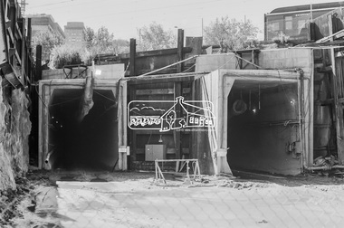
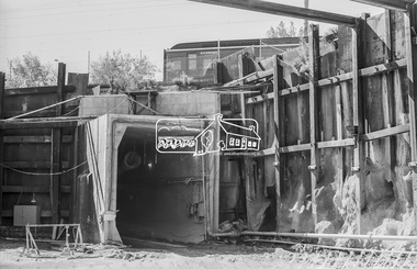
Photograph, George Coop, Open Day to view the Melbourne Underground Rail Loop (City Loop) construction, c.1980, 1983
Digital TIFF file Scan of 35mm Kodak Plus-X Pan black and white transparencycity loop, melbourne underground rail loop (murl), railway construction, tunnel -
 Eltham District Historical Society Inc
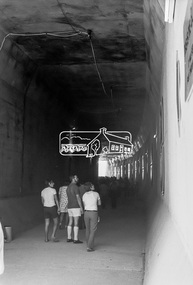
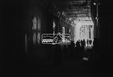
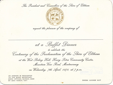
Card, Invitation to Buffet Dinner to celebrate the Centenary of the Proclamation of the Shire of Eltham at the West Riding Hall, Henry Petrie Community Centre, Mountain View Road, Montmorency, 7 April 1971, 1971
Originally donated in a photo album prepared by Doug and Gwen Orford of Historical Society trips.Invitation cardinvitation, activities, buffet dinner, henry petrie community centre, shire of eltham centenary -
 Eltham District Historical Society Inc
Photograph, View of Main Road from Eltham Shire Office, 895 Main Road, Eltham, 1967, 1967
35mm Colour positive transparency Mount - Agfacolor Service (Blue stepped)eltham shire office, main road -
 Eltham District Historical Society Inc
Photograph, View of Main Road from Eltham Shire Office, 895 Main Road, Eltham, 1967, 1967
35mm Colour positive transparency Mount - Agfacolor Service (Blue stepped)eltham shire office, main road -
 Eltham District Historical Society Inc
Photograph, View from Kangaroo Ground Tower, c.1966-c.1968, 1967c
35mm Colour positive transparency Mount - Agfacolor Service (Blue stepped)kangaroo ground, war memorial tower -
 Eltham District Historical Society Inc
Photograph, General view, Riverhill Drive, Lower Plenty, c.March 1981, 1981
Infrastructure features used by Eltham Shire Council in the construction of Riverhill Drive, Lower Plenty, c.March 198135mm colour positive transparency Kodak Kodachrome cardboard mountinfrastructure, lower plenty, riverhill drive, road construction, streets -
 Eltham District Historical Society Inc
Photograph, General view of Riverhill Drive showing pits, Lower Plenty, c.March 1981, 1981
Infrastructure features used by Eltham Shire Council in the construction of Riverhill Drive, Lower Plenty, c.March 198135mm colour positive transparency Kodak Kodachrome cardboard mountinfrastructure, lower plenty, riverhill drive, road construction, streets -
 Federation University Historical Collection
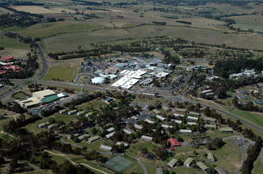
Photograph, Aerial View of the Mount Helen Campus
-
Federation University Historical Collection
Photograph, Aerial View of the Ballarat College of Advanced Education, 1986
Black and white photograph of the Mount Helen Campusmount helen campus, ballarat college of advanced education, aerial photograph, student residences -
Federation University Historical Collection
Photograph, View from Buninyong Lookout
buninyong lookout -
Federation University Historical Collection
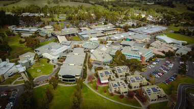
Photograph, Aerial View of Mount Helen Campus
Two aerial viewls of Mount Helen Campusaerial, mount helen campus, buildings -
Federation University Historical Collection
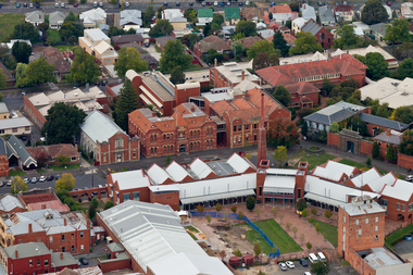
Photograph, View of the Ballarat School of Mines Campus, c1982
ballarat school of mines campus -
 Federation University Historical Collection
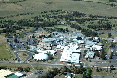
Photograph, Aerial View of Gippsland Campus, 2004
In 1989 Monash University took over the Gippsland Institute of Advanced Education to create Monash Gippsland Campus. In 2014 the University of Ballarat and the Churchill Campus of Monash University merged to become Federation University Australia.Photograph of the Federation University Gippsland Campus during its era as a campus of Monash University. gippsland campus collection, monash university gippsland campus, churchill, aerial -
 Federation University Historical Collection
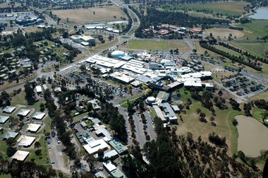
Photograph, Aerial View of Gippsland Campus looking over Northways, 2004
In 1989 Monash University took over the Gippsland Institute of Advanced Education to create Monash Gippsland Campus. In 2014 the University of Ballarat and the Churchill Campus of Monash University merged to become Federation University Australia.Photograph of the Federation University Gippsland Campus during its era as a campus of Monash University. gippsland campus collection, monash university gippsland campus, churchill, aerial, student residences -
 Federation University Historical Collection
Photograph, Aerial View of Gippsland Campus looking over the Student Residences, 2004
In 1989 Monash University took over the Gippsland Institute of Advanced Education to create Monash Gippsland Campus. In 2014 the University of Ballarat and the Churchill Campus of Monash University merged to become Federation University Australia.Photograph of the Federation University Gippsland Campus during its era as a campus of Monash University. gippsland campus collection, monash university gippsland campus, churchill, aerial, student residences -
 Federation University Historical Collection
Photograph, Aerial View of the Ballarat School of Mines
ballarat school of mines, smb, brew tower, administration building, ballarat technical art school, brewery building, former wesleyan church -
 Federation University Historical Collection
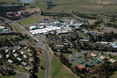
Photograph, Aerial View of Gippsland Campus, 07/06/2017
In 1989 Monash University took over the Gippsland Institute of Advanced Education to create Monash Gippsland Campus. In 2014 the University of Ballarat and the Churchill Campus of Monash University merged to become Federation University Australia.Photograph of the Federation University Gippsland Campuschurchill, aerial, gipps, gippsland campus -
 Phillip Island and District Historical Society Inc.
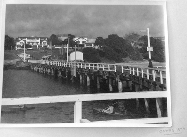
Photograph, View of Isle of Wight Hotel and Cowes jetty, 1974
Isle of Wight Hotel is no longer on this siteLarge black and white photo of the Cowes jetty, boat shed, car park, band rotunda and Isle of Wight Hotel in 1974Cowes 1974isle of wight hotel, cowes, photographs, cowes jetty, cowes jetty shed, band rotunda, cowes -
 Greensborough Historical Society
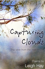
Book - Literary work, Leigh Hay et al, Capturing clouds: the view from the tree house. Poems by Leigh Hay, 2013
Leigh Hay is a local author. This is her first individual collection of poems.77p. black and white print, illustrationsfictionLeigh Hay is a local author. This is her first individual collection of poems.poetry, leigh hay -
 Greensborough Historical Society
Book - Literary work, Leigh Hay et al, Capturing clouds: the view from the tree house. Poems by Leigh Hay, 2013
Leigh Hay is a local author. This is her first individual collection of poems. Includes invitation to the launch of this book on July 13 2013.77p. black and white print, illustrations. Black and white flyer.fictionLeigh Hay is a local author. This is her first individual collection of poems. Includes invitation to the launch of this book on July 13 2013.poetry -
 Greensborough Historical Society
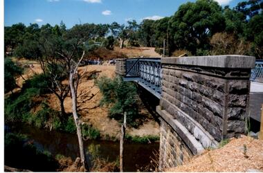
Photograph - Digital Image, Anne Paul, Opening of restored Old Lower Plenty Bridge 2001 - side view of bridge, 14/03/2001
The opening of the restored Old Lower Plenty Bridge, opened on 14/03/2001 by the Minister for Environment and Conservation Sherryl Garbutt MLA and Mayor of Banyule Cr Dale Peters. The project was jointly funded by Banyule Council and Parks Victoria. The restored bridge is the oldest remaining bridge in the former Shire of Eltham and forms part of the Plenty River Trail. This photograph shows the bridge from the side elevation, showing the bluestone and iron construction.Digital copy of colour photographlower plenty, lower plenty bridge, sherryl garbutt, dale peters, banyule council, parks victoria -
 Greensborough Historical Society
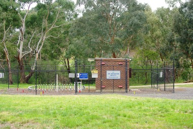
Photograph - Digital Image, Marilyn Smith, Air Navigation Facility, Montmorency, 2018. Long view, 04/12/2018
Air Navigation Facility, Palara Court Montmorency, is made up of a tower and brick building surrounded by wire fences. It is sited in parkland at the end of Palara Court close to the Plenty River Trail. Warning signs are placed on the fences, including: "This facility is provided for the control and guidance of aircraft".Digital copy of colour photographsair navigation facility, air control, palara court montmorency -
 Mission to Seafarers Victoria
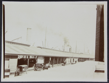
photograph - Photograph, Sepia, Australian Wharf view form the Siddeley Street mission
Australian wharf in the 1910s. On the rooftop we can read: -TED / HUDDART PARKER & CO. Inside the dock we can see barrels and bags. siddeley street institute, australian-wharf, huddart parker, walter richmond butler (1864–1949), goldsmith album