Showing 5706 items matching "view melbourne"
-
 Eltham District Historical Society Inc
Slide - Photograph, Army Map, Yan Yean (Part, 1934), c.Aug. 1990
Part of a presentation, "Roads and Byways of the Shire of Eltham", by Russell Yeoman to the 12 September 1990 Society meeting. Slides shown included copies of old photos and recent images ranging from the suburban streets of Eltham and Montmorency to the mountain roads of Kinglake. In the byways category are views of some iof the Shire's bicycle paths including then recently completed sections of the Main Yarra Trail at Lower Plenty.35mm colour positive transparency (1 of 37) Mount - Agfachrome Agfa CS System black 8 dotsinfrastructure, roads, map, shire of eltham -
 Eltham District Historical Society Inc
Slide - Photograph, View towards Garden Hill, Eltham-Yarra Glen Road, Kangaroo Ground, c.May 1988
Looking towards the Shire of Eltham Memorial Park on top of Garden Hill,, Eltham-Yarra Glen Road, Kangaroo Ground, c.May 1988. Viewed from near intersection of Kangaroo Ground-Warrandyte Road and Eltham-Yarra Glen Road35mm colour positive transparency (2 of 36) Mount - Kodak KodachromeProcess Date MAY 88Meltham-yarra glen road, kangaroo ground, shire of eltham memorial park, shire of eltham war memorial -
 Eltham District Historical Society Inc
Document - Series Listing, Fraser Faithfull et al, Series 48: Aerial Views of Shire & Newly Completed Library, May 1994, 23 colour photographs, 2000
Series consists of colour prints measuring from 215mm x 150mm up to 255mm x 200mm. Includes views of Sugarloaf Reservoir, Petty's Orchard, Residential Areas, Shire Offices and New Library.shire of eltham archives, series listing -
 Eltham District Historical Society Inc
Document - Series Listing, Fraser Faithfull et al, Series 49: Aerial Views of Shire & Newly Completed Library, May 1994, 22 colour negatives, 2000
Series consists of colour negatives recording views of Sugarloaf Reservoir, Petty's Orchard, Residential Areas, Shire Offices and New Library.shire of eltham archives, series listing -
 Eltham District Historical Society Inc
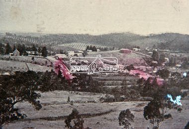
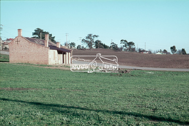
Slide, View overlooking Diamond Creek, 1907
... melbourne View overlooking Diamond Creek to the northeast, most ...View overlooking Diamond Creek to the northeast, most likely from near St John's Church, 190735 mm colour positive transparency of a newsprint image taken c.1970 Mount - Kodak Kodachrome Card13diamond creek township -
 Eltham District Historical Society Inc
Slide, View overlooking Diamond Creek, 1970
... melbourne View overlooking Diamond Creek to the northeast, most ...View overlooking Diamond Creek to the northeast, most likely from near St John's Church, 197035 mm colour positive transparency of a newsprint image taken c.1970 Mount - Kodak Kodachrome Card27diamond creek township -
 Eltham District Historical Society Inc
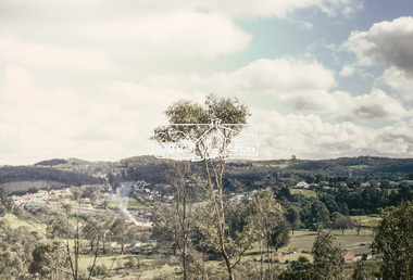
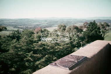
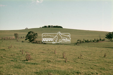
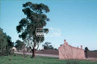
Slide, Shire of Eltham War Memorial Tower, Eltham-Yarra Glen Road, Kangaroo Ground, 24 Jul 1973
Looking east towards the tower across the western title of land purchased by Council 16 Feb. 1973 upon which the Moor-rul viewing platform and grasslands now stand.35 mm colour positive transparency Mount - Agfacolor Service (Blue)kangaroo ground, shire of eltham, war memorial tower, eltham-yarra glen road, shire of eltham war memorial -
 Eltham District Historical Society Inc
Slide, Shire of Eltham War Memorial Tower, Eltham-Yarra Glen Road, Kangaroo Ground, 24 Jul 1973
... melbourne Various views from each side of the tower lookout ...Various views from each side of the tower lookout. The Memorial Park and Shire of Eltham War Memorial tower are sited at was once known as Garden Hill and was reknowned for its panoramic views it offered tourists from the 1880s on. It was claimed that the full extent of the former Shire of Eltham could be looked upon from this viewpoint - and extending beyond.35 mm colour positive transparency x 7 Mount - Agfacolor Service (Blue)kangaroo ground, shire of eltham, war memorial tower, eltham-yarra glen road, shire of eltham war memorial -
 Eltham District Historical Society Inc
Slide, Shire of Eltham War Memorial Tower, Eltham-Yarra Glen Road, Kangaroo Ground, 24 Jul 1973
... melbourne Viewed from Eltham-Yarra Glen Road looking west from near ...Viewed from Eltham-Yarra Glen Road looking west from near Garden Hill Ct.35 mm colour positive transparency x 6 Mount - Agfacolor Service (Blue)kangaroo ground, shire of eltham, war memorial tower, eltham-yarra glen road, shire of eltham war memorial -
 Eltham District Historical Society Inc
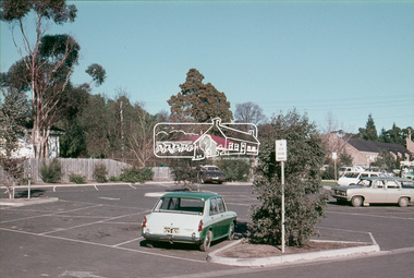
Slide, Pryor Street carpark, Eltham, 25 Jul 1973
... melbourne View through the Pryor Street carpark which ran between ...View through the Pryor Street carpark which ran between Luck and Pryor streets. The original Safeway supermarket is visible in the background off Pryor Street. Cars in the immediate vicinity are a Morris 100, and HD/HR Holden wagon and an HQ Holden35 mm colour positive transparency Mount - Agfacolor Service (Blue)eltham, pryor street, carparks, hd holden, hq holden, morris 1100, safeway supermarket, shopping centre, streets, hr holden, luck street -
 Eltham District Historical Society Inc
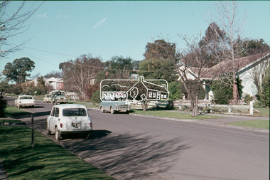
Slide, Luck Street, Eltham, 25 Jul 1973
... melbourne View looking east up Luck street from opposite the carpark ...View looking east up Luck street from opposite the carpark entrance35 mm colour positive transparency Mount - Agfacolor Service (Blue)eltham, shopping centre, streets, luck street, houses -
 Eltham District Historical Society Inc
Slide, Fernside Avenue Playground, Briar Hill, 25 Jul 1973
Construction of the playground in progress, viewed from Toorac Drive looking up to Fernside Avenue35 mm colour positive transparency Mount - Agfacolor Service (Blue)briar hill, fernside avenue, playground, toorac drive -
 Eltham District Historical Society Inc
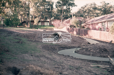
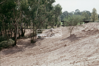
Slide, Construction of Eltham Town Park, 25 Jul 1973
Construction of Eltham Town Park; landscape has been scupltured and lakes formed. View looking up towards intersection of Bridge Street with Main Road. On the high side of Main Road is Garni Burges former home at the corner of Bridge Street then further to the left the former bakery on the corner of York Street. On the opposite corner is the feed store now the site of Le Pine Funerals. The park was later renamed Alistair Knox Park.35 mm colour positive transparency Mount - Agfacolor Service (Blue)Memorial Park 25 July 1973eltham, main road, alistair knox park, eltham town park, shillinglaw cottage, bridge street -
 Eltham District Historical Society Inc
Slide, Construction of Eltham Town Park, 25 Jul 1973
Construction of Eltham Town Park; landscape has been scupltured and lakes formed. View looking from near Shillinglaw Cottage south to Bridge Street. The park was later renamed Alistair Knox Park.35 mm colour positive transparency Mount - Agfacolor Service (Blue)Memorial Park 25 July 1973eltham, main road, alistair knox park, eltham town park, shillinglaw cottage, bridge street -
 Eltham District Historical Society Inc
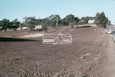
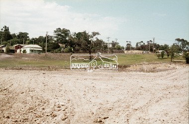
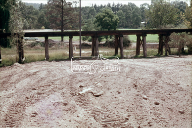
Slide, Construction of Eltham Town Park, 22 Feb 1974
Construction of Eltham Town Park, later renamed Alistair Knox Park. View looking towards the Eltham Trestle Bridge.35 mm colour positive transparency Mount - Agfacolor Service (Blue)alistair knox park, eltham town park, eltham trestle bridge -
 Eltham District Historical Society Inc
Slide, Construction of Eltham Town Park, 22 Feb 1974
Construction of Eltham Town Park, later renamed Alistair Knox Park. View looking towards the intersection of Main Road and Bridge Street. The lake body has been formed and young trees planted.35 mm colour positive transparency Mount - Agfacolor Service (Blue)alistair knox park, eltham town park, bridge street, main road -
 Eltham District Historical Society Inc
Slide, Construction of Eltham Town Park, 22 Feb 1974
Construction of Eltham Town Park, later renamed Alistair Knox Park. View looking across Shillinglaw Cottage and what was to be developed as the Eltham Town Common (now the site of the Eltham Library) across to the Eltham Town Park development.35 mm colour positive transparency Mount - Agfacolor Service (Blue)alistair knox park, eltham town park, eltham tip, eltham town common, shillinglaw cottage -
 Eltham District Historical Society Inc
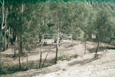
Slide, Construction of Eltham Town Park, 22 Feb 1974
Construction of Eltham Town Park, later renamed Alistair Knox Park. View looking across the front of Shillinglaw Cottage and what was to be developed as the Eltham Town Common (now the site of the Eltham Library) across to the Eltham Town Park development. To the right is the Eltham Trestle Bridge and to the left what was once the overflow site for the Susan Street Tip.35 mm colour positive transparency Mount - Agfacolor Service (Blue)alistair knox park, eltham town park, eltham tip, eltham town common, eltham trestle bridge -
 Eltham District Historical Society Inc
Slide, Construction of Eltham Town Park, 22 Feb 1974
Construction of Eltham Town Park, later renamed Alistair Knox Park. View looking up along Panther Place and Shillinglaw Cottage to Main Road.35 mm colour positive transparency Mount - Agfacolor Service (Blue)alistair knox park, eltham town park, main road, panther place, shillinglaw cottage -
 Eltham District Historical Society Inc
Slide, Construction of Eltham Town Park, 22 Feb 1974
Construction of Eltham Town Park, later renamed Alistair Knox Park. View looking towards Bridge Street and shows the Diamond Creek and formation of the Diamond Creek Trail.35 mm colour positive transparency Mount - Agfacolor Service (Blue)alistair knox park, eltham town park, bridge street bridge, diamond creek -
 Eltham District Historical Society Inc
Slide, Construction of Eltham Town Park, 22 Feb 1974
Construction of Eltham Town Park, later renamed Alistair Knox Park. View looking towards Bridge Street.35 mm colour positive transparency Mount - Agfacolor Service (Blue)alistair knox park, eltham town park, main road, bridge street -
 Eltham District Historical Society Inc
Slide, Construction of Eltham Town Park, 22 Feb 1974
Construction of Eltham Town Park, later renamed Alistair Knox Park. View looking up towards Main Road and the old bakery and feed store on opposite corners of York Street. The feed store is the present site of Le Pine Funerals.35 mm colour positive transparency Mount - Agfacolor Service (Blue)alistair knox park, eltham town park, main road -
 Eltham District Historical Society Inc
Slide, Construction of Eltham Town Park, 22 Feb 1974
Construction of Eltham Town Park, later renamed Alistair Knox Park. View looking towards the Eltham Trestle Bridge through to Central Park.35 mm colour positive transparency Mount - Agfacolor Service (Blue)alistair knox park, eltham town park, eltham trestle bridge, central park -
 Eltham District Historical Society Inc
Slide, Construction of Eltham Town Park, 22 Feb 1974
Construction of Eltham Town Park, later renamed Alistair Knox Park. View looking towards the Eltham Trestle Bridge through the trees.35 mm colour positive transparency Mount - Agfacolor Service (Blue)alistair knox park, eltham town park, eltham trestle bridge -
 Eltham District Historical Society Inc
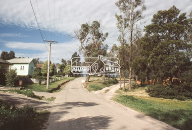
Slide, View looking northeast to turnabout near 10 McCarthy Grove, Montmorency, c.Oct. 1980
One of a series of images of roads and infrastructure taken by Eltham Shire Council Planning and Engineering officers. They provide perspective of the changes in housing styles and road development that began sweeping in from the mid 1970s with increasing urbanisation of what was once more outlying suburbs and regions.35 mm colour positive transparency Mount - Kodak Kodachrome CardProcessed Oct 1980houses, infrastructure, mccarthy grove, montmorency, roads -
 Eltham District Historical Society Inc
Slide, View looking southwest to turnabout near 9 McCarthy Grove, Montmorency, c.Oct. 1980
One of a series of images of roads and infrastructure taken by Eltham Shire Council Planning and Engineering officers. They provide perspective of the changes in housing styles and road development that began sweeping in from the mid 1970s with increasing urbanisation of what was once more outlying suburbs and regions.35 mm colour positive transparency Mount - Kodak Kodachrome CardProcessed Oct 1980houses, infrastructure, mccarthy grove, montmorency, roads -
 Eltham District Historical Society Inc
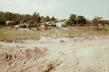
Slide, Maroondah Aqueduct, Research, Victoria, 22 Mar. 1981
... melbourne This view shows the area that would develop ...This view shows the area that would develop into the Research Industrial Estate. In centre distance though largely hidden by trees is the site of the Research Hall, which was later demolished and a new Eltham Little Theatre constructed in 1988 as a bicentennial project. The hills in the distance near the power lines now a housing estate.35 mm colour positive transparency (1 of 5) Mount - Agfachrome Agfa CS System black 8 dotsactivities, heritage excursion, maroondah aqueduct, research (vic.), shire of eltham historical society -
 Eltham District Historical Society Inc
Photograph, Kerb and channeling works, Beard Street and Main Road, Eltham, 3 Sep 1981
Roll of film taken by Eltham Shire Council officers of roads and houses in the Eltham East area, 3 September 1981 prior to construction of new water main; including views of existing damage to footpaths and gutters and general views of Beard Street. These images provide a perspective of housing estate developments and changes in housing styles and road development which began sweeping in from the mid 1970s with increasing urbanisation of what was once more outlying suburbs and regions.35mm colour positive transparency (1 of 28) Mount - Kodak Kodachrome Cardbeard street, eltham, footpaths and gutters, infrastructure, roads, main road