Showing 5238 items matching " 28"
-
 Bendigo Historical Society Inc.
Map - CAMPBELL COLLECTION: BENDIGO AND DISTRICT MAPS, 6-4-28
Map. Sedgwick, Parishes of Strathfieldsaye, Lyell, and Sedgwick. Scale 20 chains to 1 inch. Total area 5372 acres. Prepared in W.P.B. from C.L.and A. Plans by W.J.Galbraith 6-4-28. (number 400 in map cupboard 1)W.J.Galbraith.map, bendigo, agricultural lands -
 Federation University Historical Collection
Booklet, Back to Bacchus Marsh, 1930, 1930
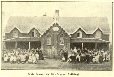
The 1930 Back to Bacchus Marsh celebrations were held on 23 to 28 October 1930. The committee were Cr L.M. Gugdale (president), A.W. Bond (General secretary), W. Grant Morton, J.G. Wells, Dr E. McDonald, Charles Dickie, G.H. Anderson, F.M. Crisp, W.R. Vigor. Bacchus Marsh State School No. 28 was established in 1851 as a National School in a rented building on the right-hand side of Bacchus Marsh-Melbourne Road, just beyond Woolpack Inn. Several willow trees mark the site. H.G. Ball was the first Head Teacher of the school, and the enrolmen towas 34. In 1854 Governor Charles Hotham visited the school. In 1855 two new schools, East and West, were recommended. School No. 28 closed in 1862 and the sitre was sold. The present school site was purchased in 1865 for 67 pounds. The cost of the building was 782 pounds. (Visions and Realisations, Vol 3., 1973) A clock purchased by public subscription was placed in the front of the building to the memory of scholars who served during World War One. (Back to Bacchus Marsh, 1930)Brown covered book of 44 pages. Contents include Bacchus Marsh and its soldiers, Red Cross, Lerderderg Gorge, Werribee Gorge, Lerderderg Park, Coimadai, Darely Firebrick Co., Myrniong, Underbank, Balliang, Rowsley, Parwan, schoosl, churches, Shire Council, Federal Milk Pty Ltd, Bacchus Marsh Milk, Old Maddingley Bridge Images include: * Bacchus Marsh looking east, 1930 * Bacchus Marsh Looking West, 1872 * Bacchus Marsh Looking West, 1930 * Aerial View of Bacchus Marsh Township looking east * Aerial View of Bacchus Marsh Township looking south * Bacchus Marsh Agricultural Society & Pastoral Society, 1893 (named), * Original Bacchus Marsh State School No 28 * Holy Trinity Bacchus Marsh * Bacchus Marsh Baptist Church * St Bernard's Catholic Church * Bacchus Marsh Methodist Church * St Andrew's Presbyterian Church Bacchus Marsh * View of Maddingley Park, showing Original Courthouse, 1890 * Werribee Gorge * Underbank Stud Farm * Ballarat State School Number 28. Signed 'C. Hodgson'bacchus marsh, maddingley, maddingley park, underbank, lerderderg park, coimadai, darely firebrick co., myrniong, balliang, rowsley, parwan, schoosl, churches, shire council, federal milk pty ltd, bacchus marsh milk, old maddingley bridge, police, police paddock, maddingley gates, crisp, mccormack, cain, harkness, howe, bence, mcdonald, mcfarlane, cosgrave, flagg, burnip, scott, lodge, cameron, vallance, bacchus marsh state school, bacchus marsh state school no 28., geology, r.w. thompson, lederderg gorge, weribee gorge, comadai, darley firebrick company -
 Melton City Libraries
Photograph, John Dowling, 1884
John Dowling and Bridget Dowling nee Keane's children were Mary born c1835 Died March 6 th 1909, Eliza born c1836 Died in Melton in 1869 and Ann born c1840/41 Died 8th October 1924 aged 84 years. Great Grandfather of Fred, Marjorie, Edna, A Bruce and Maxwell John Dowling was born in 1801and died on 28/4/1885 and Bridget Dowling nee Keane born 1803 died 12 July 1889 aged 86 yearsPhoto taken at Dungarvan, Kilkenny County, Ireland.Written on the back Dungarvan Kilkenny County Ireland rec 22/1/84 85 yrs old (might be the hand writing of William Daley) Died 28/4/1885 (hand writing unidentifiedlocal identities -
 Ballarat Tramway Museum
Negative - Set of 2, Wal Jack, 2/06/1935 12:00:00 AM
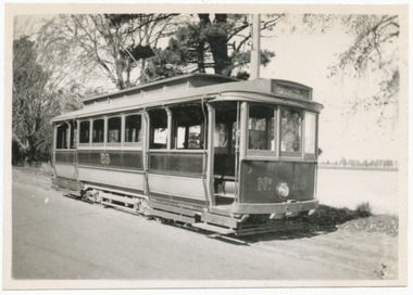
.1 Negative of a black and white photograph of Ballarat No. 28 near the SEC depot in Wendouree Parade, has Lake in the background. Tram in the ESCo colour scheme of Red and Cream/yellow - shows high bumper and small door and single step that was provided on opposite corners. Photo 2-6-1935. Alan Bradley advised in an e-mail 27/9/2006 that According to the rolling stock cards No. 28 was altered to the final one-man style and re-painted from red to green on 12/3/1938, the last Ballarat car to be so treated. 3566.2 - Digital image from the Wal Jack Ballarat Album of the same photograph as 3566.1 Rear of photo, image i2, dates the image as 2.6.1935. Image btm3566i3.jpg made from negative (N705) from within Wal Jack papers ex Keith Kings - (3200dpi - 19MB) scan - added 19/7/2019. Record Revised to updated for better images etc. 19/7/2019. See image i2 for rear of photograph. See image i3 for hi res scan of print. See image i4 for hi res scan of negative. On rear of .1 in ink "SEC Ballarat 5241, "No. 28 (read and cream) altered with steps at opposite corners only. Wendouree Parade 2.6.35" and has the number T5, within the Wal Jack stamp.trams, tramways, sec, esco, livery, colour schemes, tram 28 -
 Greensborough Historical Society
Photograph - Digital image, Marilyn Smith, Grave of Wilfred (Ted) and Rita Wieland, St Helena Cemetery, 28/07/2003
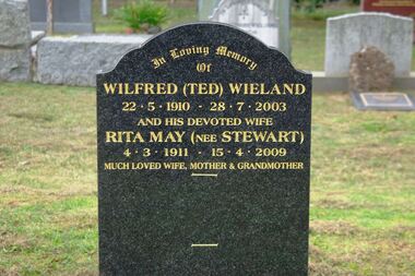
The Grave of Wilfred (Ted) Wieland (died 28/07/2003) and Rita May Wieland (nee Stewart) (died 15/04/2009), St Helena Cemetery.St Helena Cemetery was originally the burial place of the Beale family and friends. The first burials took place in the 1850s. There are now over 200 burials.Digital copy of colour photograph (grave)st helena cemetery, wieland family -
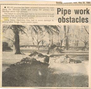 Bendigo Historical Society Inc.
Newspaper - CASTLEMAINE GAS COMPANY COLLECTION: BENDIGO ADVERTISER, 28/05/1984
Cut out from the Bendigo Advertiser of Monday May 28, 1984. ''Pipe work obstacles'' An old gas pipe has been renewed between the main along the Bendigo creek and Camp Hill primary and Bendigo senior high schools.newspaper, bendigo advertiser, gas related item -
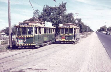 Ballarat Tramway Museum
Slide - 35mm slide/s, Keith Caldwell, 1963
Yields information about trams 28 and 18 at the Grey St loop on the Sebastopol line.Agfa colour slide, white cardboard mount, photo by Keith Caldwell during 1963 of: Trams 28 (Sebastopol) and 18 (Lydiard St Nth) crossing at the Grey St Loop, Albert St Sebastopol. No. 28 has a Twin Lakes sign and 18 a dancing at Civic Hall on their dash panels. No. 28 has a Georgette Ladies Salon roof advertisement.In ink "1963"tramways, trams, albert st, sebastopol, grey st loop, gray st, tram 28, tram 18 -
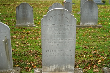 Greensborough Historical Society
Photograph - Digital image, Marilyn Smith, Grave of Francis, Henry and Bessie Wingrove, St Helena Cemetery, 28/05/1892
The Grave of Francis William Wingrove (died 28/05/1892), Henry Vivian Wingrove (died December 1855) and Bessie Wingrove (died 1955), St Helena Cemetery.St Helena Cemetery was originally the burial place of the Beale family and friends. The first burials took place in the 1850s. There are now over 200 burials.Digital copy of colour photograph (grave)st helena cemetery, wingrove family -
Friends of Ballarat Botanical Gardens History Group
Work on paper - Letter to Mr Ford from Doctor Ferdinand von Mueller 28/7/71, Topping the Blue Gum Tree, 28/7/71
This letter was written by Baron Ferdinand von Mueller, Melbourne Botanic Gardens to Mr Ford, Ballarat Town Clerk and is evidence of the advisory role von Mueller played, especially in the 1880's, in terms of the Ballarat Botanical Gardens.Doctor von Mueller was a valuable contributor to the development and planning of Ballarat Public Gardens. He visited Ballarat regularly and was also examiner for the Botany course at the Ballarat School of Mines.Photocopy of the original yellowed letter on two white sheetsPhotocopied letter written longhand in black ink. Left hand side in faint handwriting underlined, "Dr. Mueller, Topping the gum tree, 28/7/71".john garner, doctor, ballarat botanical gardens, melbourne botanic gardens, baron ferdinand von mueller, doctor von mueller, doctor mueller, mr ford town clerk, blue gum trees, botany course school of mines, george longley, benevolent home gardens, director melbourne botanic gardens, victorian government botanist., john garner collection, gardens, ballarat -
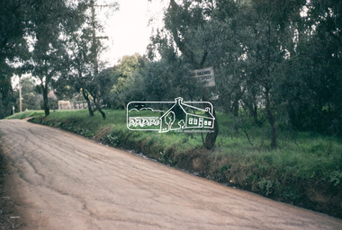
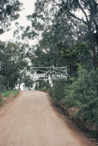
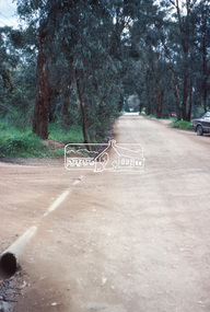
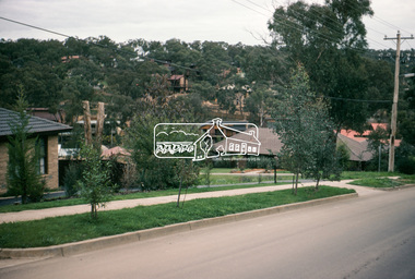
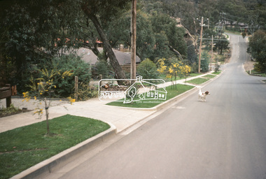
 Eltham District Historical Society Inc
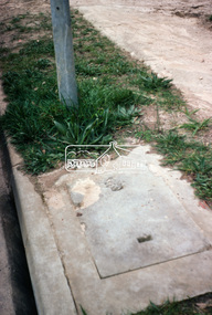
Photograph, Kerb and channeling works, Beard Street and Main Road, Eltham, 3 Sep 1981
Roll of film taken by Eltham Shire Council officers of roads and houses in the Eltham East area, 3 September 1981 prior to construction of new water main; including views of existing damage to footpaths and gutters and general views of Beard Street. These images provide a perspective of housing estate developments and changes in housing styles and road development which began sweeping in from the mid 1970s with increasing urbanisation of what was once more outlying suburbs and regions.35mm colour positive transparency (1 of 28) Mount - Kodak Kodachrome Cardbeard street, eltham, footpaths and gutters, infrastructure, roads, main road -
 Eltham District Historical Society Inc
Photograph, Beard Street, Eltham, 3 Sep 1981
Roll of film taken by Eltham Shire Council officers of roads and houses in the Eltham East area, 3 September 1981 prior to construction of new water main; including views of existing damage to footpaths and gutters and general views of Beard Street. These images provide a perspective of housing estate developments and changes in housing styles and road development which began sweeping in from the mid 1970s with increasing urbanisation of what was once more outlying suburbs and regions.35mm colour positive transparency (1 of 28) Mount - Kodak Kodachrome Cardbeard street, eltham, infrastructure, roads, horse, park road -
 Eltham District Historical Society Inc
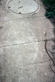
Photograph, Foothpath and kerb damage, Bainbridge Drive, Eltham, 3 Sep 1981
Roll of film taken by Eltham Shire Council officers of roads and houses in the Eltham East area, 3 September 1981 prior to construction of new water main; including views of existing damage to footpaths and gutters and general views of Beard Street. These images provide a perspective of housing estate developments and changes in housing styles and road development which began sweeping in from the mid 1970s with increasing urbanisation of what was once more outlying suburbs and regions.35mm colour positive transparency (1 of 28) Mount - Kodak Kodachrome Cardeltham, infrastructure, roads, bainbridge drive, footpaths and gutters -
 Eltham District Historical Society Inc
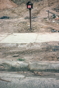
Photograph, Foothpath and kerb damage, Madine Way, Eltham, 3 Sep 1981
Roll of film taken by Eltham Shire Council officers of roads and houses in the Eltham East area, 3 September 1981 prior to construction of new water main; including views of existing damage to footpaths and gutters and general views of Beard Street. These images provide a perspective of housing estate developments and changes in housing styles and road development which began sweeping in from the mid 1970s with increasing urbanisation of what was once more outlying suburbs and regions.35mm colour positive transparency (1 of 28) Mount - Kodak Kodachrome Cardeltham, infrastructure, roads, footpaths and gutters, madine way -
 Eltham District Historical Society Inc
Photograph, Madine Way, Eltham, 3 Sep 1981
Roll of film taken by Eltham Shire Council officers of roads and houses in the Eltham East area, 3 September 1981 prior to construction of new water main; including views of existing damage to footpaths and gutters and general views of Beard Street. These images provide a perspective of housing estate developments and changes in housing styles and road development which began sweeping in from the mid 1970s with increasing urbanisation of what was once more outlying suburbs and regions.35mm colour positive transparency (1 of 28) Mount - Kodak Kodachrome Cardeltham, infrastructure, roads, madine way, tadema park -
 Eltham District Historical Society Inc
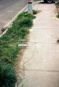
Photograph, Beard Street, Eltham, 3 Sep 1981
Roll of film taken by Eltham Shire Council officers of roads and houses in the Eltham East area, 3 September 1981 prior to construction of new water main; including views of existing damage to footpaths and gutters and general views of Beard Street. These images provide a perspective of housing estate developments and changes in housing styles and road development which began sweeping in from the mid 1970s with increasing urbanisation of what was once more outlying suburbs and regions.35mm colour positive transparency (1 of 28) Mount - Kodak Kodachrome Cardeltham, infrastructure, roads, beard street, frank street, shalbury avenue -
 Eltham District Historical Society Inc
Photograph, Beard Street, Eltham, 3 Sep 1981
Roll of film taken by Eltham Shire Council officers of roads and houses in the Eltham East area, 3 September 1981 prior to construction of new water main; including views of existing damage to footpaths and gutters and general views of Beard Street. These images provide a perspective of housing estate developments and changes in housing styles and road development which began sweeping in from the mid 1970s with increasing urbanisation of what was once more outlying suburbs and regions.35mm colour positive transparency (1 of 28) Mount - Kodak Kodachrome Cardeltham, infrastructure, roads, beard street -
 Eltham District Historical Society Inc
Photograph, Beard Street, Eltham, 3 Sep 1981
Roll of film taken by Eltham Shire Council officers of roads and houses in the Eltham East area, 3 September 1981 prior to construction of new water main; including views of existing damage to footpaths and gutters and general views of Beard Street. These images provide a perspective of housing estate developments and changes in housing styles and road development which began sweeping in from the mid 1970s with increasing urbanisation of what was once more outlying suburbs and regions.35mm colour positive transparency (1 of 28) Mount - Kodak Kodachrome Cardeltham, infrastructure, roads, beard street, frank street -
 Eltham District Historical Society Inc
Photograph, Beard Street, Eltham, 3 Sep 1981
Roll of film taken by Eltham Shire Council officers of roads and houses in the Eltham East area, 3 September 1981 prior to construction of new water main; including views of existing damage to footpaths and gutters and general views of Beard Street. These images provide a perspective of housing estate developments and changes in housing styles and road development which began sweeping in from the mid 1970s with increasing urbanisation of what was once more outlying suburbs and regions.35mm colour positive transparency (1 of 28) Mount - Kodak Kodachrome Cardeltham, infrastructure, roads, beard street, grove street, valonia drive, wycliffe crescent, livingstone road -
 Eltham District Historical Society Inc
Photograph, Beard Street, Eltham, 3 Sep 1981
Roll of film taken by Eltham Shire Council officers of roads and houses in the Eltham East area, 3 September 1981 prior to construction of new water main; including views of existing damage to footpaths and gutters and general views of Beard Street. These images provide a perspective of housing estate developments and changes in housing styles and road development which began sweeping in from the mid 1970s with increasing urbanisation of what was once more outlying suburbs and regions.35mm colour positive transparency (1 of 28) Mount - Kodak Kodachrome Cardeltham, infrastructure, roads, beard street -
 Eltham District Historical Society Inc
Photograph, Beard Street, Eltham, 3 Sep 1981
Roll of film taken by Eltham Shire Council officers of roads and houses in the Eltham East area, 3 September 1981 prior to construction of new water main; including views of existing damage to footpaths and gutters and general views of Beard Street. These images provide a perspective of housing estate developments and changes in housing styles and road development which began sweeping in from the mid 1970s with increasing urbanisation of what was once more outlying suburbs and regions.35mm colour positive transparency (1 of 28) Mount - Kodak Kodachrome Cardeltham, infrastructure, roads, beard street -
 Eltham District Historical Society Inc
Photograph, Water Main Pipe Track (Madine Way-Bainbridge Drive), Eltham, 3 Sep 1981
Roll of film taken by Eltham Shire Council officers of roads and houses in the Eltham East area, 3 September 1981 prior to construction of new water main; including views of existing damage to footpaths and gutters and general views of Beard Street. These images provide a perspective of housing estate developments and changes in housing styles and road development which began sweeping in from the mid 1970s with increasing urbanisation of what was once more outlying suburbs and regions.35mm colour positive transparency (1 of 28) Mount - Kodak Kodachrome Cardeltham, infrastructure, roads, bainbridge drive linear reserve, madine way, water main pipe track -
 Eltham District Historical Society Inc
Photograph, Water Main Pipe Track (Madine Way-Bainbridge Drive), Eltham, 3 Sep 1981
Roll of film taken by Eltham Shire Council officers of roads and houses in the Eltham East area, 3 September 1981 prior to construction of new water main; including views of existing damage to footpaths and gutters and general views of Beard Street. These images provide a perspective of housing estate developments and changes in housing styles and road development which began sweeping in from the mid 1970s with increasing urbanisation of what was once more outlying suburbs and regions.35mm colour positive transparency (1 of 28) Mount - Kodak Kodachrome Cardeltham, infrastructure, roads, bainbridge drive linear reserve, madine way, water main pipe track