Showing 917 items matching " railway park"
-
 Melbourne Tram Museum
Map, Melbourne & Metropolitan Tramways Board (MMTB), MMTB Route Maps, 1979
Series of colour maps for various tram and bus routes, dated 1979. Also contained, not scanned are letters, reports, and specifications for printing these maps for use in shelters etc. Some have the Transport Information Centre telephone printed on them. Some are finished with a plastic laminate finish on either one or both sides. Show the major cross streets, parks, schools, other tram routes, major stop numbers, and railway lines. See also item 3909 for another example of these. Trams 1 - City route guide - R9/77 - showing all route numbers and destinations that passed through the CBD. 2 - Bourke St tram routes - R4/77 - East Brunswick Blyth St and East Preston Tyler St and intermediate routes, routes 95, 96, 97, 90, 89 and 88. 3 - Malvern, East Malvern, Carnegie, and East Brighton Tram Routes (from St Kilda Junction) - R1/79 - shows routes 5, 3, 67, 66, 61, 62, and 64. 4 - Elizabeth St tram routes - R12/77 - Essendon Airport, West Maribyrnong, North Coburg lines, routes 50, 58, 60, 54, 57, 52. 49, 59, 18, 20 and 19 5 - Flinders St tram routes - R5/78 - North Balwyn, East Burwood, routes 48, 40, 41, Hartwell, 28, 74 and 75 6 - Kew - St Kilda Beach - R1/79 - Route 69. 7 - Mont - Albert City - R11/77, shows routes 43. 47. 45. 44 8 - St Kilda Rd Tram Routes R12/77 - details South Melbourne Beach, route 1 and route 2 and St Kilda Beach routes 15, 16, and 55 otherwise shows where the various routes branch off St Kilda Road 9 - Batman Ave tram routes - R9/77 - Wattle Park, North Richmond and Prahran - routes 70, 71, 78 and 79. 10 - Footscray - Moonee Ponds - R3/81 - Route 82 11 - Swanston St tram guide - R1/79 - lists all routes and route numbers that branch or cross Swanston St between Grattan St and St Kilda Junction. 12 - Toorak Camberwell and Glen Iris tram route with Camberwell Junction and Malvern Town Hall, R1/79, routes 8, 7, 6, 72, and 73 shown. 13 - West Preston - Beach tram routes - R12/77 - routes 10, 11, 9 and 12, 14 - William St tram routes - R12/77 - Route 55, 56, and 63 - South Melbourne Depot and Domain. Buses 1 - Footscray, Sunshine, Deer Park, Nth Altona & Fishermans Bend - R2/79 2 - Box Hill bus routes to Templestowe, Heidelberg & East Kew - R6/78 - notes superseded by R3/82 3 - Plan of Russell St Melbourne bus departure bays. 4 - Box Hill, Mitcham & Ringwood bus routes to East Doncaster & Warrandyte - R3/82 5 - City - Warrandyte & East Doncaster bus routes - R3/82 & R6/78 6 - Bulleen - City - Port Melbourne - Garden City Bus route - R6/78 7 - North Altona - City bus route - 11/78 8 - Clifton Hill - Elsternwick - R2/79 9 - La Trobe - Northland - West Heidelberg - City Bus Service via East Freeway - 11/79 and R3/81 10 - Box Hill, Mitcham & Ringwood Bus Routes to East Doncaster & Warrandyte - R10/84 - with the Metropolitan Transit logo.Yields information about tram and bus routes in late 1970s early 1980s.Book - brown comb binding, card and clear plastic covers containing both bound and unbound maps and documents.K C Painter on front cover in ink.tramways, mmtb, tram routes, maps, bus routes, route numbers, routes, route guide -
 Melbourne Tram Museum
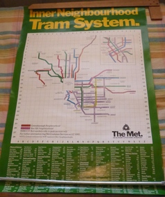
Poster, The Met, "Inner Neighbourhood tram system", mid 1980's
... of interest, sporting facilities, parks and gardens, railway stations... of interest, sporting facilities, parks and gardens, railway stations ...Poster, full colour printed on gloss paper titled "Inner Neighbourhood tram system", giving a diagrammatic Map of the tram system, suburbs, tram route destination names and route numbers and peak service route numbers. Has a separate section for the City area. Shows the routes that ran into the Greensborough and Box Hill Neighbourhoods. At the base of the map has The Met logo and name, a customer service number which has been glued over the printed number. At the base of the poster is a location guide for places of interest, sporting facilities, parks and gardens, railway stations etc.trams, tramways, the met, map, tickets, neighbourhood tickets, tramways -
 Bacchus Marsh & District Historical Society
Map, Maddingley Township, Parish of Parwan, circa 1890s
... , rivers, creeks, park lands, the railway line and Bacchus Marsh... are present in the map, These include the Bacchus Marsh Railway ...Maddingley is a locality or township within the broader township area of Bacchus Marsh. This map is not dated. However features in Maddingley which appeared in the 1880s and 1890s are present in the map, These include the Bacchus Marsh Railway Station and the Bacchus Marsh Showgrounds. The main residential and commercial area of Maddingley is shown on this map in an area bounded by Bacchus Street, Barry Street, Griffith Street and Maddingley Road. Other streets visible are Franklin Street, Inglis Street, Labilliere Street, McCrae Street, Moore Street and part of Station Street.A single page paper map showing land allotments, streets, rivers, creeks, park lands, the railway line and Bacchus Marsh railway station in the township of Maddingley. The map is pasted into a bound volume containing 76 maps or plans in total. bacchus marsh victoria maps, maddingley victoria maps, land use, maddingley victoria history -
 Canterbury History Group
Map - Canterbury Subdivisions
... Park Estate Great Railway Estate Grange Estate Map Canterbury ...A collection of 6 maps with notations showing the names and dates of land subdivision in Canterbury and surrounding suburbs.canterbury, logans estate, shrublands estate, claremount park estate, arklow hill estate, griffin estate, monomeath estate, mont albert park estate, great railway estate, grange estate -
 Stawell Historical Society Inc
Photograph, Aerial Photos of Stawell from a Hot Air Balloon 1985 -- 12 Photos
Series of 12 Aerial Photos of Stawell. Hot Air Balloon 1985. Photos taken during hot air balloon rides May & June 1935. The rides left from land near leisure complex, Houston St and Newington Rd corner. The rides first over Stawell and drifted towards the Black Range. This vacant site is now the location of Stawell indoor heated and outdoor pools. 1 & 2. Setting up balloon. 3. North Park Area Lamont St. 4. Netball & Tennis courts Athletic track. 5 Wimmera St, Trotting track & Drive-in Scallan St. & Main St. 6. State School 502 Jenning-Campbell & Houston St's. 7 Ligar St. crosses Campbell & Houston St's. 8. Ord St, 502 School yard. 9. Central Park Napier, Wakeham & Shirreff St's also Railway & Foot Bridge. 10. Central Park. 11. Sloane St. on left Trotting track & Drive-in. 12. The Old Lake oval. Series of twelve photos mostly consisting of aerial photos and two of a large balloon on the ground. stawell -
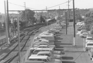
 Ringwood and District Historical Society
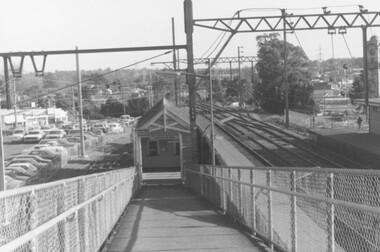
Photograph, Ringwood Railway Station - ramp leading down to No. 2 platform looking west, combined with the station car park bordering Station St
Black and White PhotographDesciption of location on rear of photo -
 Eltham District Historical Society Inc
Photograph, Old dairy on the Brinkkotter farm, Research, Vic, Jul. 2001
The original St Mary’s Roman Catholic Church (1865-1912) was built of clay brick with buttress walls and a slate roof on the corner of Fordhams Road and Maria Street (Main Road), Eltham South, opposite the present-day Wingrove Park. It was blessed on September 3, 1865. With the arrival of the railway in 1901 and the town centre moving closer to the station, the decision was made to relocate the site of the church to its present-day location on Henry Street at the corner of Main Road. A new timber weatherboard church, also called St Mary's was erected and blessed on October 13, 1912. The church and land cost £1,400 (Evelyn Observer). The original brick church was demolished in the 1920s and the bricks and windows were recycled to build a dairy on the Brinkkotter farm at Research. The timber church was destroyed by fire in 1961 and a new modern architectural (1960s) style church was erected in its place and named Our Lady of Help Christians Church.Colour photographresearch (vic.), brinkkotter, catholic church, eltham, roman catholic church, st marys catholic church -
 Ringwood and District Historical Society
Photograph, Ringwood Railway Yards
... Ringwood railway yards and car park 1984...Ringwood railway yards and car park 1984 Black and White ...Black and White PhotographRingwood railway yards and car park 1984 -
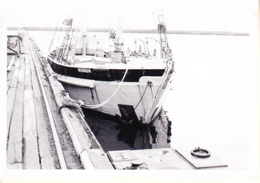 Flagstaff Hill Maritime Museum and Village
Photograph - Vessels, Sail and Steam Ships, c. 1972-1975
Andy Clapham owned and operated a boat yard on the Maribyrnong River in Footscray, Victoria. The river runs into Port Phillip Bay (sometimes known as Hobson’s bay) at Williamstown, an area with a history of trades associated with the shipping and construction industry. Andy Clapham’s photographs include those of the Reginald M and one of Polly Woodside, another vessel restored and used as a maritime exhibition. Andy Clapham’s letter of 1972 was posted in a and envelope with an early Australian decimal currency stamp showing the profile portrait of Queen Elizabeth II, and valued at 7 cent. Andy offered invaluable advice to the Flagstaff Hill Historic Park Planning Board regarding the purchase a vessel suitable for use as an exhibit once Flagstaff Hill was opened. The Planning Board was set up by the Warrnambool Chamber of Commerce and approved by the City Council and State Government. Flagstaff Hill was investigating vessels in Adelaide and Tasmania as well as Melbourne. Andy looked at several vessels in 1972-1973. He also serviced the Reginald M among other vessels belonging to Captain Julian Dyson of Yarra Ferries, who had casually offered the vessel to Flagstaff Hill as a price that was unattainable at the time. Flagstaff Hill later requested photographs of the hull to discern the dimensions and also the condition of the timbers as well as wanting advice on its seafaring capability. In 1972 the Flagstaff Hill Historic Park Planning Board – Chairman J. (John) S. Lindsay (1972-1980), Secretary J. (James) Mark – wrote a letter of appreciation to Mr A. (Andy) Clapham of 3 Charles Street Footscray ... “Dear Mr. Clapham, The Board has asked me to write to you to express our appreciation for the assistance you have offered us through our Chairman John Lindsay. The information you have already given us has been invaluable, in that is shows us that we have not been setting out to do something that is impossible. We look forward to receiving further information from you as it becomes available and we appreciate that you must be busy enough without our problems. Members of our Board hope to call and see you on a trip to Melbourne in the near future. The Board is optimistic about the future of Flagstaff Hill as a Maritime Museum and look forward to you visiting Warrnambool to examine what we believe will be an ideal site. Yours faithfully, James Mark.” ABOUT the vessel “Reginald M” The vessel “Reginald M” was a two-masted, timber coastal vessel built by John Henry Murch in Birkenhead, Port of Adelaide, South Australia. It was named after Reginald Murch. (It was occasionally referred to as the Reginald “Emm”). Its construction took approximately 6 months using many materials and fittings from salvage yards. It is believed that the keep was hewn from two telegraph poles! Reginald M was launched at Largs Bay in 1922. Reginald M was approximately 30 metres long and was fore-to-aft ketch rigged with an ‘auxiliary’ motor to support any loss of sail power. The Reginald M was built to service the coastal ports of South Australia to Port Victoria on the York Peninsular, Spencer Gulf. It freighted cargo from port to port cheaply and efficiently. It had a very shallow draft and a flat bottom, enabling it to come close to shore and sit high and dry at low tide, or to be beached on the sand. It could easily skim over reefs due to its flat bottom. Wagons could be loaded and unloaded directly from the side of the vessel. Over the years her cargo included guano, barley, wool, horses, cattle, timber, explosives, potatoes, shell grit and gypsum. The Murch brothers from Port Adelaide were owners of the Reginald M and Richard Murch as the Captain. On April 9, 1931, Reginald M weathered a large storm in St. Vincents Gulf, SA, suffering much damage; the mast snapped and the crew laboured for four hours to free it up by severing the mast and rigging. The crew patched it up and slowly returned to Port Adelaide with only a portion of the insured cargo being damaged. The crew members at that time were owner Mr John Henry Murch of Wells Street Largs Bay, Skipper Mr R Murch – John’s brother, Murray – son of Captain Murch and Seaman John Smith. At some stage it seems that the Reginald M was used as a Customs vessel “H.M.C. No. 3, Pt Adelaide” as shown in a photograph in Flagstaff Hill’s collection. In 1969 Reginald M’s last freight trip left Marion Bay, carrying grain, wool and explosives. In late 1970 it was sold to the Mount Lyall Mining and Railway Clompany and used as a barge to carry explosives. In 1972 The Navy League of Strahan, Tasmania, purchased the vessel for use by the Strahan Sea Cadet Unit at Macquarie Harbour; it was renamed “T.S. Macquarie”. (This plan did not come to pass.) In 1974 Mr Andrew Rennie of East Brighton, Melbourne, brought Reginald M for shipping purposes, He sailed it from Strahan to Melbourne, planning to use it for pleasure sailing. The Reginald M was later sold at auction to Captain Julian Dyson, owner of Yarra Passenger Ferries in Melbourne. Later in 1975 funds became available to Flagstaff Hill Maritime Village to purchase the Reginald M. It was then restored and used as an exhibit here for many hears. Flagstaff Hill’s collection also includes various objects related to the Reginald M: - Photographs of Reginald M over the years in various aspects of its use - a life buoy with the inscription of “Pt. Adelaide” - helm section that was removed and replaced during restoration - a bullet found in pieces of timber during the 1979 restoration ABOUT THE POLLY WOODSIDE On the bow in the Polly Woodside's photograph is the word "RONA". the Polly Woodside was built at Belfast in 1885. In 1904 the vessel was sold to A.H. Turnbull of New Zealand and renamed "RONA". The letter and photographs are significant for their association with the Reginald M, an Australian built coastal trader now on the Australian Register of Historic Vessels (number HV000562). The letter and photographs are also significant as part of both the history of Flagstaff Hill and the history of the vessel “Reginald M” that has been on display in the lake for many years. Objects retained from this boat are included in Flagstaff Hill’s collection of maritime history.Packet with photographs and negatives in a KODAK envelope. The photographs are of two sail and steam vessels; twelve (12) black and white photographs of the 'Reginald M', and one (1) colour photograph of the Polly Woodside, plus six (6) negative strips. Included int he packet is a letter in stamped and postmarked envelope addressed to Mr A Clapham of Footscray. The envelope postmarked 9 Dec 1972, with the Warrnambool postcode 3280, A 7c Australian postage stamp in attached to the envelope. They are associated with Flagstaff Hill’s acquisition of the vessel “Reginald M”. Envelope "9 DEC 1972 / 3280" Postage stamp "7c" "Australia" Inscriptions on one Reginald M;; "REGINALD M" and "Pt ADELAIDE H.M.C. No. 3" Inscriptions of the Polly Woodside; "RONA / MSC" "MHI / NO. 1" Ball point ink, reverse of photograph "POLLY WOODSIDE"flagstaff hill, warrnambool, shipwrecked coast, flagstaff hill maritime museum, maritime museum, shipwreck coast, flagstaff hill maritime village, great ocean road, vessel reginald m, reginald emm, t. s. macquarie, h.m.c. no. 3, pt adelaide, australian register of historic vessels (number hv000562), boat building trade, jack murch, john henry murch, birkenhead, port adelaide sa, largs bay sa, coastal trader south australia, 1920 ketch reginald m, marion bay produce, mount lyall mining and railway company, navy league of strahan, tasmania, melbourne ferry company, flagstaff hill historic park planning board, john lindsay, james mark, andy clapham of footscray, andy clapham boat builder, kodak photograph packet envelope, kodak super-size prints, kodak australia pty ltd, australian postage stamp 1972 - 7c -
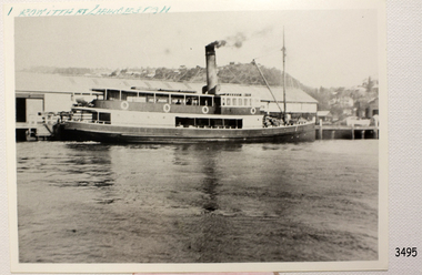 Flagstaff Hill Maritime Museum and Village
Photograph - Vessel, Steam Ship, S.S. Rowitta, Early 20th century
... along Pertobe Road, through the Surfside Caravan Park and over... along Pertobe Road, through the Surfside Caravan Park and over ...The subject of this photograph is the S.S.Rowilla, a passenger steam ferry built in Hobart for use in Tasmania's rivers, the Derwent and the Tamar. The photograph shows her docked at the Charles Street Wharf in Launceston. The S.S. Rowitta was built by Purdon & Featherstone, at Battery Point, Hobart (Tasmania) in 1909 from Huon Pine and Kauri planking. Her final configuration included three masts and a ship rig. S.S. Rowitta took its first voyage from Hobart to Launceston in 1909 and operated for 30 years as a passenger ferry on the Tamar and Derwent Rivers. She also served as a freighter, an army supply ship, a luxury charter ferry and a floating restaurant as well as a prawn boat at Lakes Entrance. (She has also been named “Sorrento” and “Tarkarri”.). In the very early days of Flagstaff Hill ‘Rowitta’ was purchased from Lakes Entrance by Warrnambool City Council and the Victorian State Government for $20,000. The Rowitta had a hull configuration very similar to a local boat named the SPECULANT, which played a key role in the Port of Warrnambool in the early 1900s. The Speculant was the largest ship ever registered with Warrnambool as her home port. Local owner and trader P J McGennan & Co, (Peter McGennan) used her as a freight carrier to Melbourne and timber trader between New Zealand and Victoria. She sunk at Cape Otway in 1911 on a voyage to Melbourne. In 1974 Rowitta was delivered to Port Fairy and then later sailed to Warrnambool’s Breakwater where she was lifted out of Lady Bay and loaded onto the back of a long transport truck and slowly and carefully driven along Pertobe Road, through the Surfside Caravan Park and over the railway line, into Flagstaff Hill’s Maritime Village. Transfer arrangements were coordinated by Jack Morse, of Morse Engineering, a member of the Flagstaff Hill Planning Board, and Ken Goyen, a local crane operator. The ‘Rowitta’ was originally acquired to be rebuilt to match the original SPECULANT. When finances became tight in 1976 a review of all plans ended in the decision to restore the “Rowitta” to her original configuration. She was then restored, renamed the original name of “Rowitta” and installed in the Village’s Harbour Lake to become one of the popular vessels on display for visitors to enjoy. It was the decision of the Advisory Committee to Flagstaff Hill to have Rowitta demolished in April 2015 due to extensive deterioration. Items associated with the Rowitta continue to be held in Flagstaff Hill Maritime Village’s Collection.The photograph of the passenger ferry S.S. Rowitta.is significant for its association with Tasmanian history from the early to mid-1900s. It is also connected to the history of the Rowitta, which was a large exhibit on display at Flagstaff Hill Maritime Village from the museum’s early beginnings until the vessel’s end of life 40 years later. The Rowitta represents the importance of coastal traders to transport, trade and communication along the coast of Victoria, between states, and in Australia before rail and motor vehicles. The vessel was an example of a ferry built in the early 20th century that served many different roles over its lifetime of over 100 years. Black and white photograph of the steamship S.S. Rowitta at Charles Street Wharf, Launceston. It shows the vessel docked at the Charles Street Wharf in Launceston. Smoke is coming from its funnel and there are people on board. There is a handwritten inscription on the top edge of the photograph. The vessel was built in 1909 by Purdon & Featherstone, Hobart. Blue-green handwriting on top left margin "ROWITTA AT LAUNCESTON"flagstaff hill, warrnambool, shipwrecked-coast, flagstaff-hill, flagstaff-hill-maritime-museum, maritime-museum, shipwreck-coast, flagstaff-hill-maritime-village, photograph, s.s. rowitta, charles street wharf,, launceston., purdon & featherstone, rowitta, tarkarri, speculant, purdon & featherstone of hobart, passenger ferry 1909, sorrento -
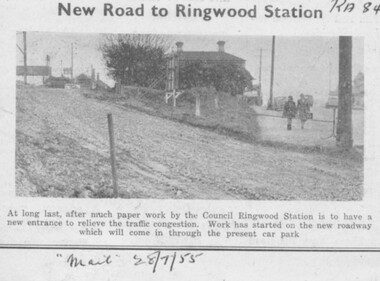 Ringwood and District Historical Society
Newspaper, Ringwood Mail newspaper clipping 28/07/1955 - Construction of new traffic entrance to Ringwood Railway Station
Small newspaper clipping containing photograph and textHeading reads, "New Road to Ringwood Station" Printed below photograph, "At long last, after much paper work by the Council Ringwood Station is to have a new entrance to relieve the traffic congestion. Work has started on the new roadway which will come in through the present car park". "Mail 28/7/55". -
 Bendigo Historical Society Inc.
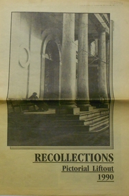
Newspaper - PETER ELLIS COLLECTION: RECOLLECTIONS PICTORIAL LIFTOUT
Historical lift out. Newspaper. Titled RECOLLECTIONS Pictorial Lift out 1990.1 looking down Mitchell St. from Railway Bridge. 2 Original railway station viewed from Mitchell St. bridge. 3 The great extended Hustlers mine. 4 1873 photo recently extended town hall with corn exchange at front left. 5 looking north westerly from city rec reserve at royal hustlers. 6 children play on mullock heap in front of a view of westerly quarter of Sandhurst. 7 Bank of Victoria, Mitchell St. left is Bendigo's original post office. 8 Looking down from what is now Rosalind Park. Shamrock Hotel can be seen on corner of Williamson St. and Pall Mall. This photo predates the construction of post office and law courts. 9 girl eating fairy floss. 10 4 kids on 1 horse in procession. 11 monkey and pedal car, a novelty attraction 1940's. 12 pony rides. 13 flying horses (ride). 14 processions past city hall. 15 Original ANZ bank corner Williamson St. & Pall Mall. 16 Chinese Dragons Bendigo Easter Fair 1940's. 17 City Hall viewed from Bull St. 18 City Hall original ceiling. 19 new town hall 1861. Mike Butcher, local historian. 21 Interior plan of city hall (ground floor) 22 circa 1920's 23 Tattered fragment original architect's drawing. 24 original assembly room. 25 Camp Hill PS Shamrock hotel without top story 27 shop with signage advertising Bushells, Bex and Swallow's Biscuits. 28 View from where fountain is now. 29 Hargreaves St. Looking south, now Hargreaves mall. Horse drawn water tank watering down road. 30 Central Deborah Gold mine poppet head. 31 Borough town hall, tram ways. 32 Original ANZ Bank corner Williamson St. and Pall Mall, demolished in mid 1960's. 33 Bush's store corner Williamson and Myer streets.34 Men on boat, don't know what or where. 35 Shearers. 36 men on a three wheeled bike. 37 4 Gold miners with shovels. 38 6pm closing, no trade Sundays, no women in main bar. 39 Peaceful scene Castlemaine 1940's Photographer Alan Doney. 40 Qantas Jet the City of Bendigo Tullamarine Airport. BCV-8 camera man & Advertiser photographer. 41 Ladies. 42 Tennis -> men and women (women in hats). 43 Sandhurst footy team. 44 Early school photos.bendigo, history, photographic history -
 Ballarat Tramway Museum
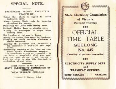
Photograph - Digital image, State Electricity Commission of Victoria (SECV), "Official Timetable Geelong No. 45"
Digital image or copy of the SEC "Official Timetable Geelong No. 45", 16 image files - 32 pages, giving details of the fares, transfers, luggage or parcels, lost property, times of each tram on the Belmont (1), Chilwell (2), East Geelong (3), Eastern Park (4), Newtown (5), North (6), West Geelong (7). Gives details of railway station trams, transfer ticket arrangements, depot workings and the night signs carried out each tram. Based on the 4d max fare, it is a circa 1949 timetable - see reference. See also Reg Item 5629 for Timetable No. 39, c1943 and 8552 for a photocopy of No. 47, March 1953 and 9821 for a photocopy of No. 46. See BTM document, "SEC fare changes - by law references etc.doc, dated 3/9/2006.trams, tramways, geelong, timetables -
 Ringwood and District Historical Society
Document - Research Notes, Richard Carter, Land Subdivisions in Ringwood 1890-1950
Handwritten table listing main local pre-1950s subdivisions in the Ringwood area, with estate names, streets, number of allotments for sale, and where known, vendor agent, LP (Lodged Plan) title registration number, and auction/sale date, some with sale price.Pg1 RINGWOOD STATION ESTATE LP3070 (Year?) Station Street, William Street (now Kendall Street), Wantirna Road, Station Street Pg1 RINGWOOD TOWNSHIP ESTATE LP5577 (1913) Station Road (now Warrandyte Road), Pratt Street (part now Aird Street), Whitehorse Road Pg2 RINGWOOD ORCHARD ESTATE LP4315 (1914) Brysons Road, Hillcrest Road, Anzac Avenue, Sulva Road Pg3 RINGWOOD RAILWAY ESTATE LP7522 (1918) Whitehorse Road (now Mount Dandenong Road), Dublin Road, Freeman Street, Patterson Street, Bona Street Pg4 THE RINGWOOD ESTATE LP7578 (1919) Warrandyte Road, Hobart Street, Paxton Street, Arnold Street Pg5 GARDEN FARMS ESTATE (LP?) (1919) Canterbury Road, Armstrong Road, Bungalook Road, Orchard Road, Bayswater Road (now Mountain Highway) Pg6 THE RINGWOOD ESTATE (SECOND SUB-DIVISION) LP7604 (1919) Warrandyte Road, Tamar Street, Derwent Street, Mersey Street Pg7 RINGWOOD STATION ESTATE LP7703 (1919) Bedford Road, Williams Grove (now Lena Grove) Pg8 RINGWOOD TOWNSHIP ESTATE LP8198 (1919) Wantirna Road, Ellison Street, Haig Street, Greenwood Avenue Pg9 EASTFIELD ESTATE (LP?) (1920) Eastfield Road, Longview Road, Pleasant Rise, The Mount Pg10 ELECTRIC RAILWAY ESTATE RINGWOOD LP9473 (1922) Campbell Street, Myrtle Avenue, George Street (now Tudor Court), Henry Street (now Myrtle Avenue), Williams Grove (now Lena Grove) Pg11 RINGWOOD PARK ESTATE LP7884 (1922 - two stages) Wonga Road (now Loughnan Road), William Street, Andrew Street, Harrison Street Pg12 HEATHMONT STATION ESTATE LP11009 (Date? - after 1922) Lisgoold Street, Viviani Crescent, Balrour Avenue, Station Street (now part Heathmont Road and part Wainui Street) Pg13 RINGWOOD RAILWAY ESTATE LP10507 (1923) Whitehorse Road, Sherbrooke Avenue, Burwood Avenue, Bonview Avenue, Heatherbrae Avenue, Grant Crescent Pg14 GARDEN HOMES ESTATE (LP?) (1923) Mullum Road, The Centreway, Wattle Crescent (now Wattle Avenue) Reserve Crescent (now Reserve Road) Pg15 DUBLIN ROAD ESTATE LP11993 (1923) Alexandra Road, Vonadawn Avenue, Green Street, Wood Street, Howard Avenue, Bedford Road, Dublin Road Pg16 CARLINGA ESTATE RINGWOOD LP9620 (1923) Bourke Street, Bond Street, Ringwood Street Pg17 PRATT'S JUNCTION ESTATE (LP?) (1923) Junction Street, Georges Road, Oliver Street, Whitehorse Road Pg18 EAST RINGWOOD ESTATE LP10492 (1923) Bona Street, Patterson Street, Miller Grove, Fairview Avenue, Eastfield Road, Whitehorse Road (now Mount Dandenong Road) Pg19 COLEMAN'S HEATHMONT ESTATE LP9974 (1923) Canterbury Road, Bedford Road, Alvena Crescent, Coleman Street, Leonard Street (now Royal Avenue) Pg20 RINGWOOD HEIGHTS ESTATE LP10506 (1924) Whitehorse Road, Bonview Avenue, Grant Crescent, Hillcrest Avenue, Heatherbrae Avenue, Margaret Street, Mary Street Pg21 EAST RINGWOOD STATION ESTATE LP10551 (1924) Knaith Road, Wenwood Street, Lois Street, Victoria Street, Station Street (now Railway Avenue) Pg22 GRAND VIEW ESTATE LP11019 (1924) Whitehorse Road, Rupert Street, Herbert Street, Leonard Street Pg23 RINGWOOD RAILWAY ESTATE & RINGWOOD HEIGHTS ESTATE - FINAL SECTIONS LP10506 & LP10507 (1924) Whitehorse Road, Sherbrooke Avenue, Burwood Avenue, Bonview Avenue, Heatherbrae Avenue, Margaret Street, Mary Street, Grant Crescent Pg24 RINGWOOD EAST ELECTRIC STATION ESTATE (LP?) (1924) Railway Parade (now Patterrson Street), Federal Road, Howship Avenue (part now French Street), Dublin Road, Rosedale Crescent Pg25 BEDFORD PARK (now Ringwood Secondary College) (LP?) (1924) Bedford Road, Adams Street, Anderson Street, Joyce Street, Graham Road Pg26 CROWN JEWEL ESTATE LP11645 (Private sales after 1924) Mount Dandenong Road, Mirabel Avenue, Valda Avenue, Evon Avenue, Velma Grove Pg27 GRAND CENTRAL ESTATE LP10917 (1925) Heathmont Road, Great Ryrie Street, Douglas Street, Garden Street, Bellevue Avenue Pg28 RINGWOOD (unnamed estate - 1926) Nelson Street, Seymour Street, Whitehorse Road Pg29 EAST RINGWOOD RAILWAY STATION ESTATE (YEAR? - 25 shops 60 villas) Railway Avenue, Dublin Road, Lawrence Grove, Stanley Avenue, Knaith Road Pg30 CHARM VIEW ESTATE (LP?) (year? - after 1926) Canterbury Road, Heathmont Road, Dickasons Road, Bennjett Avenue, Orchid Street Pg31 SUNBEAM ESTATE LP12150 (Circa 1925) Govt Road (now Old Lilydale Road), Sunbeam Avenue, Holland Road, Everard Street (now Everard Road) Pg32 FAIRVIEW ESTATE EAST RINGWOOD LP10853 (Circa 1924) Eastfield Road, Patterson Street, Margaret Street (now Short Street) Pg33 EAST RINGWOOD TOWNSHIP ESTATE LP3025 (Circa 1924 - 35 allotments) Mount Dandenong Road, Grey Street, Eastfield Road Pg34 EAST RINGWOOD TOWNSHIP ESTATE LP3025 (Circa 1924 - 49 allotments) and STATE SCHOOL ESTATE (26 allotments) and EAST RINGWOOD STATION ESTATE (14 shop sites) Mount Dandenong Road, Grety Street, Dunn Street, Eastfield Road, King Street, Holland Road, Dublin Road, Patterson Street, Bona Street Pg35 EAST RINGWOOD CENTRAL ESTATE LP17004 (1948) Knaith Road, Shasta Avenue, Talofa Avenue, Russet Road, Dublin Road Pg36 WARE ESTATE LP43360 (1958) Ware Crescent, Davey Drive, Grey Road (now Grey Street), Mount Dandenong Road Pg37 Lot 57 Kendall Street LP3070 (1939) £75.0.0 Pg37 Lot 14 LP7346 (year?) £225 Pg37 Lot 8 WHITE HORSE ESTATE LP14010 (year?) Maroondah Hwy, Seymour Street £98.9.0 Pg37 Lots 4-14 incl. LP10902 (year?) £300 Pg37 Lots 69&70 LP2216 (1939) Bedford Road, Pitt Street £500 Pg37 Lots 60&70 LP2216 (year?) £460 Pg37 MOUNTAIN VIEW ESTATE LP10902 (1936) Lots 1&2, 19-22 Wantirna Road, Daisy Street £50 Pg38 RAILWAY STATION ESTATE RINGWOOD EAST LP7522 (1925) Lots 16 to 19 £250 Pg38 RINGWOOD PARK ESTATE (LP?) (1924) Lot 112 Munro Street £230 Pg38 RINGWOOD TOWNSHIP ESTATE (LP?) (1925) Lot 57 Wantirna Road £850 Pg38 ELECTRIC RAILWAY ESTATE LP9473 (1925) Lot 98 & 99 £180 (30/- foot) Pg38 ELECTRIC RAILWAY ESTATE LP9473 (year?) Lot 100 £233.12.6 incl improvements (£2.12.6 foot) Pg38 Lot 22&23 Bedford Road Heathmont (LP & year?) £675 incl improvements Pg39 Lot 9 Mullum Mullum Road LP8221 (1923) £150 Pg39 Lot 27 Haig Street LP8198 (1925) £825 Pg39 Lot 56 Haig Street cnr Wantirna Road LP8198 (1923) £171 Pg39 Lots 3 & 4 Loughnan Road LP9626 (192?) £147 Pg39 Lots 98 & 99 Myrtle Avenue LP9473 (1925) £180 Pg39 Lots 80 & 81 Myrtle Avenue LP9473 (1929) £150 Pg39 Lot 30 Sherbrooke Avenue LP10507 (1926) £700 incl improvements Pg40 Lot 10 (year?) LP7703 £750 Pg40 Lot 36 (year?) LP7522 £25 Pg40 Lot 38 Pitt Street LP2216 (year?) £350 Pg40 Lot 7 Dublin Road cnr Green Street LP11993 (year?) £300 -
 Eltham District Historical Society Inc
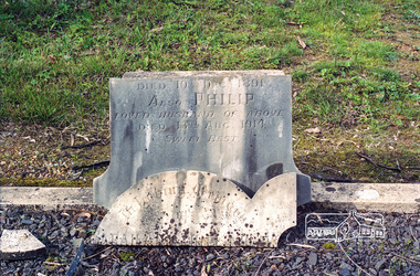
Negative - Photograph, Harry Gilham, Grave of Sarah and Phillip Shillinglaw, Eltham Cemetery, Victoria, Sep 2009
Philip Shillinglaw and his wife Sarah came to Eltham in 1882. Their property "Wattle Brae" originally encompassed present-day Eltham Central Park and part of Eltham Library, extending north to include Andrew Park and the site of the railway station. An early photo shows that much of it was planted for crops. They also had cows; in 1913 Philip wrote to the local paper complaining about an earlier report that one of them had been killed on the railway line. "I give an emphatic denial to the report. It is not true." Their house Shillinglaw Cottage (built by George Stebbings) still exists, though it was moved with funding from local residents in 1963-64 when faced with demolition to make room for new Council Offices. Philip was actively involved with the Methodist Church as preacher, Church Steward and Sunday School teacher. A Sunday School picnic and a sports carnival were held on his paddock. Eight of his children attended Eltham Primary School. In 1908 he ploughed part of the schoolyard (possibly for use as a garden) free of charge. When Philip died in 1914, his funeral was described as one of the largest ever seen in Eltham. He and Sarah are buried in Eltham Cemetery. In Loving Memory of Sarah Ann Shillinglaw Died 10th Dec. 1891 Also Phillip Loved husband of above Died 18th Aug. 1914 Sweet BestRoll of 35mm colour negative film, 6 stripsKodak GC 400-9eltham cemetery, gravestones, phillip shillinglaw, sarah ann shillinglaw -
 Melbourne Tram Museum
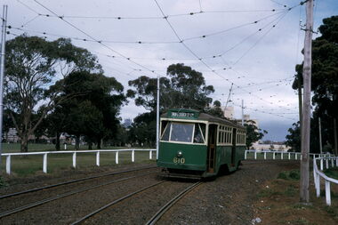
Slide - Y1 610 - Royal Park line, Warren Doubleday, August 1971
... reversing at the Royal Park crossover with the railway station... reversing at the Royal Park crossover with the railway station ...Set of two photos of Y1 class tram No. 610 on a tour on the Royal Park line August 1971. The second photo shows the tram reversing at the Royal Park crossover with the railway station in the background. Note the open ballast style track and railway style weighted point lever.Yields information about the Royal Park tram line.Set of two Kodachrome cardboard mounted slides.tramways, tramcars, y1 class, tram 610, royal park, railways -
 Eltham District Historical Society Inc
Film - Video (VHS), Nillumbik Shire Council, The Nillumbik Story, 1996
PART 1 – NILLUMBIK (00:00-07:17) Opening features various scenes around Nillumbik Shire. For 40,000 years Nillumbik was the home of the Wurundjeri people. Robert Hoddle gave the district its name. Jock Ryan, then president of Nillumbik Historical Society discusses the names Nillumbik and Diamond Creek. In the late 1830s white occupation began with gold found in Warrandyte in 1851 and 12 years later at Diamond Creek -the Diamond Reef which led to the Caledonian gold rush. Jock Ryan discusses the Diamond Creek mine, which was thriving until it burnt out in 1915. Large numbers of workmen moved into area in late 1870s to construct the Maroondah Aqueduct. With growing population of Melbourne, the nearby Yan Yean system had severely disrupted the flow of the Plenty River, forcing the closure of three flour mills there. The aqueduct came to the rescue carrying water 66km from Healesville to Preston. When the Diamond Creek gold mine burnt down the local economy suffered but fruit growing industry had already been established and Diamond Creek became a thriving fruit growing centre. Interview with Jack Powell, a long-time fruiterer at St Andrews market, his family had lived in the area for a hundred years, 3 to 4 generations, “a lot of hard work”. By the time the railway arrived fruit growing was no longer competitive. The railway brought the city closer and day trippers. The Green Wedge separates the shire from the more densely developed neighbours such as Whittlesea, Doncaster, Templestowe, Bulleen and Greensborough. Population at the time (1996) was 19,000 but links to the past remain strong. Mudbrick houses along the Heritage Trail The saving of Shillinglaw Cottage from demolition in 1963 and relocation brick by brick. PART 2 – ENVIRONMENT (07:18-14:44) Peter Brock (with Bev Brock in background) at St Andrews market discusses his childhood growing up in the district and the environment and the values it instilled upon him and his own family. The Brocks have been in the district since the 1860s. Nillumbik Shire responsible for managing three catchment areas; Diamond Creek, Arthurs Creek and Watsons Creek. Follows the course of the Diamond Creek commencing in Kinglake through the district to its confluence with the Yarra River at Eltham at Eltham Lower Park. Highlights Eltham Lower Park community revegetation program and the newly constructed (1996) viewing platform built of new and recycled timbers at the confluence of the Diamond Creek and Yarra River. Also featured are outdoor recreation on the river and at Eltham Lower Park including the Diamond Valley miniature railway. Sugarloaf reservoir and recreational activities and fishing. Aerial view of Memorial Park and Shire of Eltham War Memorial tower at Garden Hill, Kangaroo Ground. Significant tourism opportunities for the shire with 3 million potential day-trippers in metropolitan Melbourne. Council and community working together to find a way to promote the shires natural and artistic assets. At Arthurs Creek, the Brock family and neighbours working together to take care of their waterway. Peter Brock’s uncle, Sandy Brock talks about environmental management and the Arthurs Creek Landcare group and actions to eradicate blackberry problem. Having previously planted Cypress rows they are replacing them with indigenous species to improve the water supply, keeping cattle out of the creek bed to improve the quality downstream flowing into the Yarra. Eltham East Primary School Band playing “All things bright and beautiful” merges into scenes of the bushland sanctuary set aside by the school in 1980 with unidentified teacher discusses the sanctuary and their education program and school children’s comments. Plight of a family of Wedgetail eagles nesting in the path of a developer’s bulldozer at North Warrandyte and actions to save their nesting areas. PART 3 – ARTS (14:45-22:00) Arts and Jazz festival at Montsalvat featuring interviews with Sigmund Jorgensen discussing Montsalvat and its principles. Also Matcham Skipper. Clifton Pugh’s funeral at Montsalvat and his legacy at Dunmoochin near Cottlesbridge with artists in residence, at the time, Chicago artist Charles Reddington who discusses the benefits of the experience. An unidentified female artist also talks about the program and why people are drawn to the area. Unidentified man on street talking about the amount of talent in the area, artists, poets, musicians, authors. Artist Ming Mackay (1918-2009) interviewed talking about the people she mixes with on “the Hill”. Works of local artists are displayed Eltham Library Community Gallery and Wiregrass gallery with a new coffee shop at the Wiregrass making it an even more popular destination. Music at St Andrews Hotel (may be a little bit country) and the Saturday market where likely to hear anything. Sellers and patrons at the market asked about what attracts them to the market and where they came from. Scenes of poets/authors giving readings. CREDITS Music by John Greenfield from the CD Sweet Rain “The Snow Tree”, Uncle Music UNC 2001 Cameras - David Mirabella and Peter Farragher Editor – Olwyn Jones Written and Produced by Jason Cameron A Jason Cameron Proction for Nillumbik ShireProvides a record of the relatively newly created Shire of Nillumbik at the time and the features and attactions of the shire in its people arts, culture and environmentVHS Cassette (five copies) DVD (one copy) Converted to MP4 file format 0:22:00, 1.60GBvideo recording, arthurs creek, arthurs creek landcare group, artists, artists in residence, arts, arts festival, authors, blackberry, brock family, bulldozer, bulleen, bushland sanctuary, caledonian gold rush, charles reddington, clifton pugh, cottlesbridge, cypress rows, developer, diamond creek, diamond creek mine, diamond reef, diamond valley miniature railway, doncaster, dunmoochin, education program, eeps, eltham, eltham east primary school, eltham east primary school band, eltham library community gallery, eltham lower park, environment, fishing, flour mill, fruit growing, fruiterer, garden hill, gold mining, green wedge, greensborough, heritage trail, hurstbridge railway line, jazz festival, jock ryan, kangaroo ground, kangaroo ground tower, kinglake, maroondah aqueduct, matcham skipper, memorial park, ming mackay (1918-2009), montsalvat, mudbrick houses, music, musicians, nesting area, nillumbik historical society, nillumbik shire, north warrandyte, old timer, orchards, peter brock, plenty river, poets, population, recreation, recreational activities, revegetation, robert hoddle, sandy brock, shillinglaw cottage, shire of eltham war memorial, sigmund jorgensen, st andrews hotel, st andrews market, sugarloaf reservoir, templestowe, the hill, tourism, viewing platform, warrandyte, water catchment area, watsons creek, wedgetail eagle, whittlesea, wiregrass gallery, wurundjeri, yarra river, jack powell -
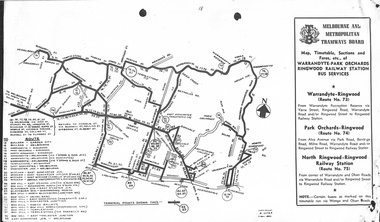 Ringwood and District Historical Society
Pamphlet, Information on revised Bus ticketing arrangements from Warrandyte, Park Orchards or North Ringwood to Ringwood Railway Station Copyright 1963
Bi-fold map, timetable and fare structure for the Melbourne and Metropolitan Tramways Board, introduced as from November 1962 -
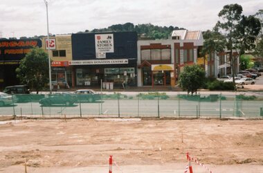 Ringwood and District Historical Society
Photograph, Ringwood Railway Precinct with northside shops showing car park where Adelaide St was located in 2009
-
Glen Eira Historical Society
Document - TOURS
There are two copies of the Discover Caulfield guide produced by the Caulfield Historical Society. One from 1982 which contains twelve pages, seven of which are typed and the last five a continuation of the guide added later, hand-written. The other is a modern typed version of the same document, including information at the end that "Notes prepared by R. Ballantyne, 25th July, 1982, updated by Betty Snowball, 1992 and Gladys Vallati 4th August, 1995". They both detail a pictorial tours of the mansions and gardens in the City of Caulfield, similar but not identical.caulfield, mansions, gardens, homes, ‘lirrewa’, lirrewa grove, caulfield city hall, smith sydney, ‘halstead’, bambra road, halstead road, caulfield historical society, messrs. upton and smith, civic establishments, dickson james dr., houses, national trust, st. stephen’s church, balaclava road, gothic (revival) architecture, messrs. haddon and henderson, st. aloysius, archbishop of melbourne mannix dr., caulfield park, hawthorn road, inkerman road, kambrook road, paddy’s swamp, cannizzo philip, caulfield city council, trams, orrong road, grimwade house, ‘harleston’, grimwade frederick sheppard, primary schools, caulfield art centre, ‘stanmark’, art galleries, ‘craigellachie’, person william, pearson eliza, francis newton mr., greenmeadows gardens, milburn grove, greenmeadows house, lempriere john, mayors, ‘glenfern’, boyd john captain, boyd martin, ‘myoora’, alma road, ‘bagatelle’, christian thomas, henderson anketell, flats, building construction, ‘burreel’, kooyong road, burreel avenue, francis john, stephen sidney, allan george l., ‘royston’, renwick s. mrs., sargood frederick sir., ‘glen eira’, ricketson henry, caulfield hospital, royal southern memorial hospital, caulfield general medical centre, ‘ripponlea’, reed and barnes, architects, towers, rippon emma, rippon thomas, guilfoyle william, employees, ‘the village houses’, regent street, st. george’s road, cottages, bent thomas sir., jones louisa mrs., nathan benjamin, ‘anselm’, glenferrie street, queen anne style, haddon robert, historical buildings, princes’ park, ‘glenmore’, watts thomas, more hugh, glenhuntly road, gates, villas, ‘hopetoun’, hopetoun street, webb charles, hopetoun hospital, harleston park, allison street, langdon montague, langdon harry joseph, ‘tarqua’, ‘labassa’, manor grove, koch john, robertson a. w., wagner john, ‘ontario’, trinity congregational church, grange road, glen huntly, churches, greek orthodox church, ‘fairfield hall’, north road, younger james, glenhuntly post office, smith alfred, smith anne, methodist church, ‘lambros the cobbler’, railways, ballantyne r., snowball betty, kahlyn private hospital, ‘kynaston’, st. mary’s jubilee school, festivals and celebrations, st. mary’s anglican church, church of england, bishop moorhouse, joynt donoman, elsternwick post office, elsternwick, elsternwick bowling club, elsternwick rsl, caulfield grammar school, davis henry rev., selwyn street, elsternwick railway station, glen eira road, barnett r. j. rev., tudor court, world war 1914-1918, ‘fairhaven’, hope george, caulfield library, plaques, cannons, ‘janvec joinery’, parkside street, ‘parkside court’, clarence street, ‘streetscene’, grange road, greenhouses, vallati gladys -
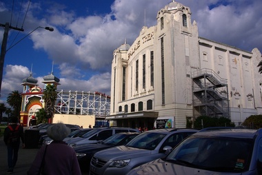 Ballarat Heritage Services
Photograph - Digital Photograph, Palais Theatre and Luna Park St Kilda triangle, c2010
... railway roller coaster Digital Image Palais Theatre and Luna Park ...Digital Imagest kilda, triange, palais, theatre, luna, luna park, scenic railway, roller coaster -
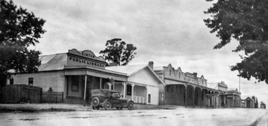 Linton and District Historical Society Inc
Photograph, Linton Public Library, Sussex Street, Linton, between 1927 and 1932
The photograph is dated to between 1927 and 1932, as the Nelson house has been renovated (this happened in 1927). Dan Cornish sold his shoe shop in 1932 (it became Murrell's newsagency). Black and white image which shows buildings in Sussex Street, Linton. The building in the foreground, the Linton Public Library, has a car parked in front of it. Other buildings are the house owned by the Nelson family, the Railway Hotel, Dan Cornish's shoe shop and the weighbridge. A gas lamp is attached to the verandah of the library building. The library building still has the curvilinear parapet which is shown in a photo of the building taken between1901 and 1914.linton public library, nelson premises, railway hotel, dan cornish shoe shop, weighbridge -
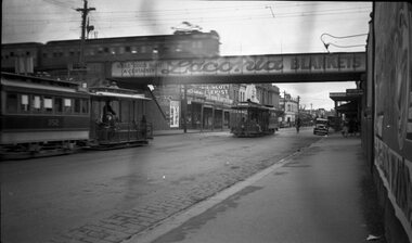 Melbourne Tram Museum
Negative - Cable trams - Johnston St Collingwood, Wal Larsen, 15/4/1939
... passing under railway bridge at Victoria Park". Written on back... "Collingwood cable trams passing under railway bridge at Victoria Park ...Photograph of two cable tram sets; one with trailer 532 westbound in Johnston St Collingwood about to pass under the railway bridge, with a Tait set on the top and another cable tram set eastbound. The bridge has an advert for Laconia Blankets and R. L. Scott Chemist. Photographer, Wal Larsen, 15/4/1939.Yields information about the Johnston St cable trams on the last day of the Collingwood line.Negative of cable tram, and black and white print.Written on rear of album print "Collingwood cable trams passing under railway bridge at Victoria Park". Written on back of print "Collingwood route, Johnston St, Clifton Hill train, passing over top, last day of running 15th April 1939, Photo Wal Larsen" Has number "No. 12 CI" and in pencil "172" in top right hand corner.trams, tramways, cable trams, johnston st, collingwood, railway, bridges, tram 532 -
 Melbourne Tram Museum
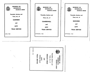
Ephemera - Timetable, Melbourne & Metropolitan Tramways Board (MMTB), Set of 30 MMTB tram timetables, 1962
Demonstrates a set of MMTB 1962 timetables.Set of 30 MMTB tram timetables, folded sheets, 4 fold, providing timetables for specific routes, day of week giving information on tram times at the terminus, sections and fares, running times. Some signed by W. J. Richards as Acting Traffic Manager, or R. C. Drummond as Traffic Manager. Route Numbers not given on cover, generally given on inside. Where a All night service was applicable, shown as well. .1 - Burwood - City - 9/1962 .2 - Camberwell - City - 9/1962 .3 - Carnegie - City - 6/1962 .4 - Domain Rd - City - 10/1962 .5 - East Brighton - City - 6/1962 .6 - East Coburg - city - 9/1962 .7 - East Malvern - Darling Rd - City 27/5/1962 .8 - East Preston - City - 11/1962 .9 - Essendon Aerodrome - City - July 1962 .10 - Essendon (Matthews Ave) - City - 7/1962 .11 - Glen Iris - City - 8/1962 .12 - Hawthorn - Spencer St - 7/1962 .13 - Kew Cotham Rd - St Kilda Beach - 8/1962 .14 - Malvern Burke Rd - City - 8/1962 .15 - Mont Albert - City - 7/1962 .16 - Moreland - City - 9/1962 .17 - West Coburg - City 7/1962. .18 - North Balwyn - Spencer St - 7/1962 .19 - North Coburg - City - 6/1962 - has Sunday only Fawkner Railway station service on rear - 6/1962 .20 - North Richmond - Prahran and St Kilda Beach - 7/1962 .21 - Northcote (via St Georges Rd) - City - 7/1962 .22 - Prahran - City - 7/1962 .23 - South Melbourne and St Kilda Beach - City - 6/1962 .24 - St Kilda Beach - City - - 9/1962 .25 - Toorak - City - 8/1962 .26 - Wattle Park - Elgar Rd - City - 9/1962 .27 - West Maribyrnong - City - 7/1962 .28 - West Preston - City - 6/1962 .29 - West Coburg - City - 10/1962 ,30 - East Preston - City - 7/1962Some have "Robert Wilson" stamp on the covers.trams, tramways, timetables, tickets, fares, mmtb, all night services -
 Ringwood and District Historical Society
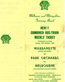
Pamphlet, Information on revised Bus-Train ticketing arrangements from Warrandyte or Park Orchards to Melbourne via Ringwood Railway Station
Bi-fold advertisement for the Melbourne and Metropolitan Tramways Board, introduced as from Sunday, 19th October, 1969 -
 Sunbury Family History and Heritage Society Inc.
Photograph, Hay shed, c1960s
The hay shed was sited on railway land fronting onto Evans Street and near Station Street. Retail shops including Harris Scarf now occupy the site. The pine trees in the background were along Horne Street.The hay was stored in this building before being transported.Cereal growing was one of the agricultural activities carried out in the Sunbury area.A scanned print of an old black and white photograph of a corrugated shed with hay bales stacked at the rear of the building. A 1960s sedan car is parked in front of the building and there is a smaller shed in the background.hay shed, railways, sunbury station, evans street, horne street -
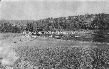 Eltham District Historical Society Inc
Photograph, Trestle Bridge, Eltham, c.1910
Most likely an F-Class 2-4-0 Steam Locomotive pushing carriage about to cross the Eltham Railway Trestle Bridge heading towards Greensborough, viewed from what was later Eltham Common and site of the re-located Shillinglaw Cottage (1964) and Eltham Library (1994). On the far side of the track on what is present day Central Park oval is a crop field. The railway was commenced in 1900 and passed through the middle of the Shillinglaw Farm. Here it passes through the farm paddocks. The train station at Eltham opened in 1902. Colour photocopy of original photo print (on loan?) 25.5 x 39 cm mounted on coreflutePencil mark at bottom "(c) 1910"eltham, trestle bridge, bridges, shillinglaw farm, f-class 2-4-0 steam locomotive, eltham railway trestle bridge, eltham trestle bridge, railway bridge, steam locomotive -
 Chelsea & District Historical Society Inc
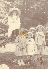
Photograph - The Brown Children, 1910
Doris, Alex, George and Jean are the grandchildren of Mr Hugh Brown. Hugh Brown (1830-1930), born in Ireland, arrived in Adelaide in 1855 and in the Mordialloc district in 1856. Mr Brown brought land in 1866 and built his farmhouse “Pine Vale” in 1870 near the site of the present Mordialloc Secondary College (then part of the property) and extended his property when the swampland was made open for selection in 1871. The property was a market garden and orchard. Hugh Brown married Zillah Baxter (1866) and they had six sons, five living to adulthood. The Brown family increased their land holding until they held a major part of the farmland between Mordialloc Creek to almost the Aspendale Railway Station. The property was a market garden and orchard. Mr Brown took an active interest in the public life of the community, a Justice of the Peace; Councillor of Dandenong Shire for over 30 years, was twice Shire President; and a founding member of the Mordialloc Mechanics Institute. Black and white studio photo of the Brown children standing on a tee-tree in Attenbourgh Park, Mordialloc.Doris, Alex, Jean, Georgehugh brown, mordialloc, jean brown, zillah brown, doris brown, alex brown, attenbourgh park -
 Melbourne Tram Museum
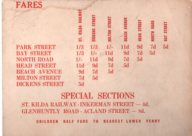
Poster, Victorian Railways (VR), St Kilda - Brighton Electric Tramway - Fares
Card sheet or poster detailing sectional fares on the St Kilda - Brighton Electric Street Railway or tramway from St Kilda Station to Park St Brighton. Lists two special sections and details Children's fares - half fare to nearest penny. Undated.Yields information about the fares on the St Kilda Brighton electric tramway.Printed card sheet, red ink on off manila card.tramways, fares, vr, st kilda brighton electric tramway -
Port Melbourne Historical & Preservation Society
Photograph, GRAHAM ST. PORT MELB
The rockery and buildings in this area of Graham Street were demolished in the 1970s when the Graham Street overpass was constructed.View of ornamental reserve (rockery) in Graham Street with buildings in the background. The decorative lights of the Maskell & McNab Memorial are visible within the rockery.graham street, parks and gardens, frederick william maskell, james mcnab, maskell & mcnab memorial, windsor railway accident