Showing 1011 items matching "bay st"
-
 Queenscliffe Maritime Museum
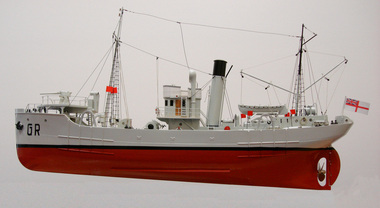
Leisure object - Model Ship, HMAS Goorangai
The H M A S Goorangai was struck by the M V 'Duntroon' on the night of 20/11/1940 in the South Channel of Port Phillip Bay. All 24 crew members of the Goorangai were lost.Model of 'Goorangai" G Rduntroon, port phillip bay, ship models -
 Queenscliffe Maritime Museum
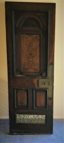
Functional object - Door from SS Edina, 1854
A ships relic from a well known Screw Steam vessel SS Edina which operated in Port Phillip for many yearsA door from bay steamer SS Edinass edina, salvage, bay steamers of port phillip -
 Queenscliffe Maritime Museum
Vehicle - Jubilee Yacht Freelance J25
Hand built by Noel Higgs of Higgs Brothers Boat Builders in Geelong in 1938Holding 3-4 people, the Jubilee is a stable, all-weather 18 foot day boat, locally designed and made for Port Phillip Bay. It’s a one-design class and, although some are newer than others, the first one ever built is still sailing and still competitive on the water!Yacht Jubilee Freelance J25boat, boat building, noel higgs, geelong -
 Queenscliffe Maritime Museum
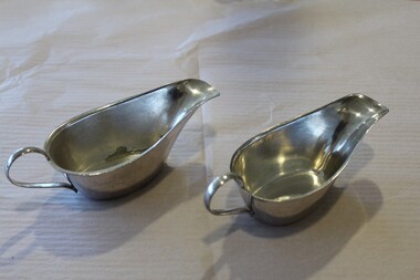
Domestic object - Silverware from Pilot Vessel Wyuna
Her role as a pilot cutter was to sail with pilots on board to meet ships entering Port Phillip Bay. Pilots would be transferred by the Wyuna's workboat to the vessel requiring pilotage while it was stopped dead in the water, with shelter provided by the vessel itself. In the early 1970s the pilot service started using fast launches to allow pilots to board while ships were still underway, and in 1979 the Wyuna was sold to the Australian Maritime College in Launceston, Tasmania as a training vessel. Wyuna served in Port Phillip as a pilot tender Significant vessel served in Port Phillip Pilot ServiceSilverware from Pilot Boat Wyuna: Salt & Pepper Pots [6] - 5 with blue glass inserts, Small spoons [3], Gravy boats [1], nutcracker [1], Plate cover [1]T.S.M.V. WYUNA on pots and gravy boats and oval spoon, P.P.P.S. on two round spoons. Makers mark on round spoonswyuna, pilots, silverware -
 Queenscliffe Maritime Museum
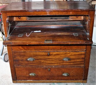
Furniture - Captain's Desk
On August 23rd, 1949, S. S. TIME was on voyage from Sydney to Melbourne with a cargo of sugar (3,000 tons), timber, general cargo and coal, when she was wrecked on Corsair Rock, entrance of Port Philip Bay. Read more at wreck site: https://wrecksite.eu/wreck.aspx?57395The remnants of the Time remained as a landmark for over 10 years before a storm sent her remains to the bottom. http://home.vicnet.net.au/~maav/diary3.htmCaptain's desk from the SSW Timess tme, shipwrecks, salvage, furniture -
 Queenscliffe Maritime Museum
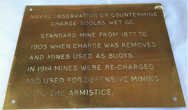
Plaque - Plaque, brass inscribed with Naval countermine information
Found in garden shed of Mr Harry Barratt [WWI Gallipoli] and donated by his grandson. In 1877 Swan island was designed to defend shipping in Port Phillip and Hobson's Bays. The scheme, involving massive expenditure, comprised a forward defence system of forts at Port Phillip heads dominated by Fort Queenscliff and South Channel Fort (artificial island), and a network of coastal batteries. Some development of fortification had occurred in the 1850s, but it was the impetus of the Jervois-Scratchley reports which led to major work being undertaken in the 1880s. The overall defence plan involved a combination of guns, mines (known as electric torpedo) and ships to defend the entrance to Port Phillip Bay. Swan Island Fort would be used to protect the minefields in the harbour, Naval observation countermine charge 500lbs wet G.C Standard mine from 1877 to 1905 when charge was removed and mines used as buoys. In 1914 mines were recharged and used for defensive mining until Armistice.Brass plaque inscribed with information on naval countermineNaval observation or countermine charge 500lbs wet G.C. Standard mine from 1877 to 1905 when charge was removed and mines used as buoys. In 1914 mines were recharged and used for defensive mining until the Armistice.sea mine, plaque, pre wwi, naval countermine, swan island -
 Queenscliffe Maritime Museum
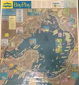
Poster - Poster Port Phillip leisure activities
Issued to encourage Victorians to learn about Port Phillip and its recreational potential Local contextLarge colour Poster with drawings of Port Phillip leisure activities Department of Youth, Sport and Recreationport phillip, bay play, youth sport and recreation -
 Queenscliffe Maritime Museum
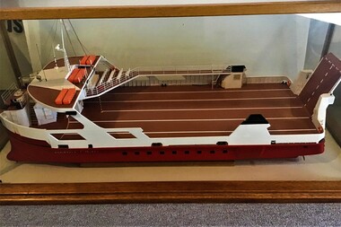
Leisure object - Model Boat
The Peninsula Princess is a single ended roll-on/roll-off vehicle ferry owned by Peninsula Searoad Transport of Victoria, Australia. It operated between the heads of Port Phillip Bay between the towns of Queenscliff and Sorrento from 1987 to 1993. It was replaced by the MV Queenscliff. Scale Model of Peninsula Princess, the first car ferry to operate between Queenscliff and Sorrento in wood and glass display casecar ferry, sorrento, queenscliff -
Queenscliffe Maritime Museum
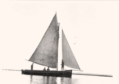
Vehicle - Yacht hull
Seen as an excellent recreation for a maritime power, racing or cruising in purpose-built vessels became increasingly popular in Britain from the beginning of the 19th century. Some immigrants brought their enthusiasms to Port Phillip Bay, holding the first regatta in 1838. The Devil Afloat, the first unequivocal pleasure yacht, arrived a year later. Regattas were organised intermittently, featuring wagers on both rowing and sailing races. The Victoria Yacht Club, founded in 1856, soon folded, but another club of that name was established in 1872 and became the Royal Yacht Club of Victoria based at Williamstown. The Albert Park Yacht Club also began on the newly improved lagoon in 1872, other clubs soon followed and inter-club regattas were organised. In the 1880s the popularity of larger yachts built for cruising, as well as for racing, increased. Sailing in smaller boats consolidated in the first three decades of the 20th century, with several more clubs formed. After the great storm of 1932 destroyed many yachts the fleet was rebuilt with new designs such as Charles Peel's Jubilee One-Design Class dinghies.Jubilee yachts were popular in Port Phillip between 1930 to 1970. In later years, they were later made of fibreglass.Timber hull of a Jubilee class yacht J82 named FLASH. jubilee yacht, timber hull -
 Queenscliffe Maritime Museum
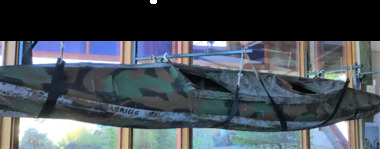
Vehicle - Kayak, Commandos
The remarkable story when 74 soldiers fought in vain to save the lives of their mates off Portsea as 3 soldiers died. Tragically, Privates Roger Wood and Edward Meyer, and Warrant Officer George "Taffy" Drakopoulos, died. Please Note: "The Rip" is also known as "The Heads", which is a dangerous stretch of water connecting Port Phillip Bay and Bass Strait. This is the only entrance for all shipping into Port Phillip Bay and to and from the Port of Melbourne, Victoria, Australia.Kayak of a similar type as those used during the ill-fated army exercise with loss of life in the rip.rip disaster, commandos, kayak, military history - army -
Queenscliffe Maritime Museum
Ceramic - Saucer
Mark verified from Staffordshire Potteries websiteOwned by Bay steamers Ltd who operated in Port PhillipSaucer, vitreous china, white glaze; 1/4 broken offBay Steamers Ltd Melbourne - black crest John Maddock and Sons Ltd Englandchina, bayside steamers -
 Queenscliffe Maritime Museum
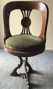
Furniture - Chair
The SS Edina's active service included the North Sea trade, ‘Crimean War’, ‘American Civil War’, Victoria’s west coast run, New Zealand to Melbourne trade, Queensland coastal trade, and of course, the Port Phillip Bay runs between the years 1880 to 1938.A saloon swivel timber chair with green velvet cushion and cast iron base from the SS Edinachair, steamers, ss edina -
Queenscliffe Maritime Museum
Vehicle - Dinghy sailing, carvel planked Swan Class
These craft were in use since the early 1900s in Swan BayCarvel planked swan class sailing dinghy designed for use in shallow Swan Bay.sailing, dinghy, carvel planked, swan bay -
Queenscliffe Maritime Museum
Functional object - Channel Marker - Colour Green
Ex Corio Bay green channel green lightSolar powered green channel marker lightchannel marker -
 Queenscliffe Maritime Museum
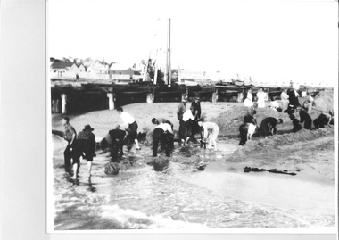
Photograph - Photo of sixteen men with shovels digging the channel, Photograph of boat channel creation series, 1934-36
QUEENSCLIFFE boat channel being dug out c1934-36Boat channel for fishing fleet protectionBlack & white photo of men with shovels digging the channel, aka The Cut, at the Bay end.Reverse - NILcommunity information, boat channel c1934-36, the cut -
 Queenscliffe Maritime Museum
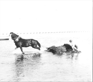
Photograph - Photo of a horse drawn dredge digging the channel aka The Cut, Photograph of boat channel creation series, 1934-36
QUEENSCLIFFE boat channel being dug out c1934-36Boat channel for fishing fleet protectionBlack & white photo of horse drawn sand dredge digging the channel, aka The Cut, at the Bay end.Reverse - NILcommunity information, boat channel c1934-36, the cut, horse drawn dredge -
 Queenscliffe Maritime Museum
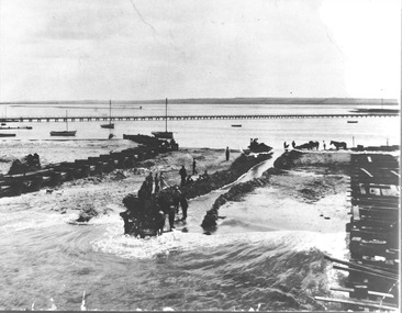
Photograph - Photo of The Cut's first flow between Port Phillip and Swan Bay, Photograph of boat channel creation series, 1934-36
QUEENSCLIFFE boat channel being dug out c1934-36Boat channel for fishing fleet protectionBlack & white photograph of the Boat Channel - The Cut's first flow connecting between the Swan Bay and Port Phillip. Reverse - NILcommunity information, boat channel c1934-36, the cut -
 Queenscliffe Maritime Museum
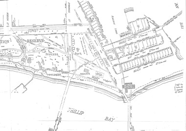
Map - Port Phillip Bay at Queenscliffe 1936, Map of Queenscliffe Parks & Foreshore, unknown
Queenscliffe life c1936Map of Queenscliffe in c1936copy of an L-shaped map of 1936 Queenscliffe foreshoreReverse - " nil ".historical references -
 Queenscliffe Maritime Museum
Photograph - Black & white photograph of the fishing boat ALMA c1931, Photo of the ALMA in Swan Bay, c1931
Trading clipper shipsAustralian coastal tradeBlack & white photograph of the fishing boat ALMA c1931Reverse - " NIL ".historical references -
 Queenscliffe Maritime Museum
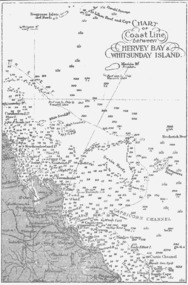
Map - B & W coastal map between Hervey Bay & Whitsunday Island, in Queensland, Coastal map, Queensland, between Whitsunday Island & Hervey Bay, Before donation in 1987
Australian coastal mapsAustralian coastal mapsCoastal 'soundings' map between Hervey Bay & Whitsunday Island, in Queensland, from an unknown book, pre-1987Reverse " NIL "old maps of australian coast -
 Queenscliffe Maritime Museum
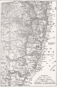
Map - B & W coastal map between Sydney & Brisbane, Australia, Coastal map, Queensland, between Whitsunday Island & Hervey Bay, Before donation in 1987
Australian coastal mapsAustralian coastal mapsCoastal 'soundings' map between Sydney & Brisbane, from an unknown book, pre-1987.Reverse " NIL "old maps of australian coast -
 Bendigo Historical Society Inc.
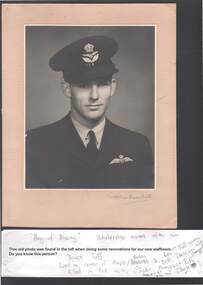
Photograph - GOLDEN SQUARE P.S. LAUREL ST. 1189 COLLECTION: BRUCE TUFF
black and white photo of Bruce Tuff: label on photo states e this old photo was found in the loft when doing some renovations for our new staffroom. Do you know this person ? Handwritten notes state e Bay of Biscay' scholarship named after him. Bruce Tuff, lived on corner of Maple/Panton St. killed in 2nd. WW. See attached document, where he baled out of his plane over the English Channel, to try to rescue his commanding officer whose plane had crashed. Written on paper insert: Sister Margaret Ruff, Harley st., Bendigo, now Elliott. Ken ?? Tuff younger, Beth Dungey - brother, Harkness St., Image shows young man, dressed in Airforce uniform. Head and shoulders portrait, mounted on buff board.education, primary, golden square laurel st p.s. -
 Bayside Gallery - Bayside City Council Art & Heritage Collection
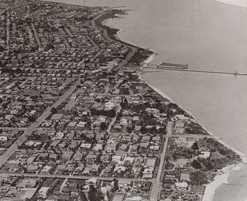
Photograph - gelatin silver photograph, Shaw-Ross Aviation Company, Airspy, Middle Brighton, 1935
brighton, middle brighton, aerial, photograph, airspy, shaw-ross aviation company, suburbs, sea baths, pier, dudley street, st ninian's road, st kilda street, brighton beach, port phillip bay -
 Bayside Gallery - Bayside City Council Art & Heritage Collection
Photograph, Department of Crown Lands and Survey, Victoria, Melbourne Project: Brighton and Elwood, 1976
The Department of Crown Lands and Survey (1857-1983) was responsible for the administration of survey and mapping and the sale, occupation and management of crown land throughout its existence. This aerial photograph shows parts of Brighton and Elwood and was taken on 1 December 1976brighton, elwood, department of crown lands and survey, aerial photograph, elsternwick park, point ormond, north road, ormond esplanade, st kilda street, glen huntly road, bayside, port phillip bay, map, cartographic material, melbourne project 1976 -
 Bayside Gallery - Bayside City Council Art & Heritage Collection
Photograph, Department of Crown Lands and Survey, Victoria, Melbourne Project: Brighton, 1976
The Department of Crown Lands and Survey (1857-1983) was responsible for the administration of survey and mapping and the sale, occupation and management of crown land throughout its existence. This aerial photograph shows parts of Brighton and was taken on 1 December 1976brighton, department of crown lands and survey, aerial photograph, bayside, port phillip bay, map, cartographic material, melbourne project 1976, brighton yacht club, middle brighton baths, north road, st kilda street, new street -
 Bayside Gallery - Bayside City Council Art & Heritage Collection
Photograph, Department of Crown Lands and Survey, Victoria, Brighton, Elwood and Elsternwick, c. 1965-71
The Department of Crown Lands and Survey (1857-1983) was responsible for the administration of survey and mapping and the sale, occupation and management of crown land throughout its existence. This aerial photograph shows parts of Brighton, Elwood and Elsternwick and was taken circa 1965-71.brighton, department of crown lands and survey, aerial photograph, bayside, port phillip bay, map, cartographic material, elwood, elsternwick, elsternwick park, elwood tram depot, elwood pier, new street, glen huntly road, st kilda street, nepean highway -
 Queenscliffe Maritime Museum
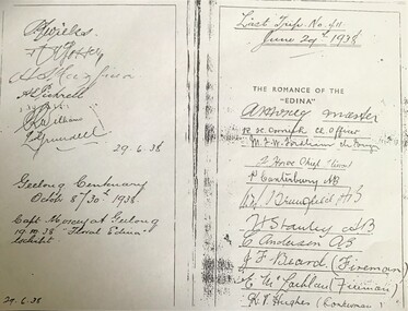
Document - copy of extract
Title: The romance of the "Edina" : the world's oldest screw-steamship : with chapters on the auxiliary steamship :Great Britain", and the Port Phillip Bay steamers past and present / by C. Dickson Gregory Author: Gregory, C. Dickson (Charles Dickson) Publication Information: Melbourne : Robertson & Mullens, 1935 Physical Description: xii, 84 p., [24] p. of plates : ill. ; 23 cm Series Link: Queenscliffe Maritime Museum General Note: Item no. Corporate Subject: Edina (Ship) Great Britain (Ship) Subject Term: Shipping -- Victoria Geographic Term: Port Phillip Bay Region (Vic.) -- History Format: Books Holds: 0 Copies: 2This iron hull single screw steamer had a long and distinguished carrier operating between 1853 and 1938. She served in the Crimean war carrying stores and horses to the Black Sea and later trading in the Mediterranean, and carrying cotton for the Confederate States in the American Civil War. Edina arrived in Melbourne under sail in March 1863 and was purchased by Stephen Henty for use from ports in western Victoria and later carried gold prospectors across the Tasman to New Zealand. After a refit in 1870 she was used in the coastal trade along the Queensland coast for Howard Smith until returning to Victoria and the Melbourne-Geelong trade as a cargo-passenger vessel. The Edina had two narrow escapes from destruction in 1898 and 1899 when she collided with other steamers, both being sunk. A further refit in 1917 altered her appearance with a new mast, funnel, bridge and promenade deck. By 1924 Edina had made over 12,000 Melbourne-Geelong passages and carried over one million people on the service. A further collision in July 1931 which sank the tug Hovell forced Edina onto a mudbank on Port Phillip Bay. She was taken out of service in 1938 but was later renamed Dinah and used as a lighter until 1958 when she was broken up and her remains used as land-fill.Extract from the book 'The Romance of the Edina' showing signatures of her last voyage crew in 1938.'The Romance of the Edina'ss edina, port phillip, steam ships -
 Queenscliffe Maritime Museum
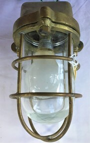
Functional object - Deck Light
The ship was built in 1953 by Ferguson Shipbuilders of Port Glasgow, Scotland for the Port Phillip Sea Pilots organisation as a pilot cutter. Her role as a pilot cutter was to sail with pilots on board to meet ships entering Port Phillip Bay. Pilots would be transferred by the Wyuna's workboat to the vessel requiring pilotage while it was stopped dead in the water, with shelter provided by the vessel itself.Brass Deck Light with globemv wyuna, port phillip pilot service -
 Queenscliffe Maritime Museum
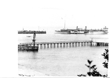
Photograph, Photographer unknown, 1903
The Hygeia was used built in 1890 and could carry 2000 passengers.It was used to transport passengers from Melbourne to Queenscliffe as well as English Royalty at times.RealismBlack & white photograph of the "HYGEIA" at Queenscliffe wharfHYGEIA 1903 on the reversesteam ship, "hygeia, queenscliffe wharf -
 Queenscliffe Maritime Museum
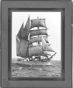
Photograph - Photograph of the "Southern Cross", Photographer unknown
An original, cardboard mounted, photograph of the sailing ship 'Southern Cross' under full sail at sea.Realism, historical, black & white photographAn original, cardboard mounted, photograph of the sailing ship 'Southern Cross' under full sail at sea.On the reverse - Miss C Hawk - Not now - 1 Madden Avenue Glenhuntley - 29 Potter Ave Rosebud 3934 - Gift from Miss Hawk"1985at sea, southern cross, sailing ship, in corio bay, 1916