Showing 925 items matching "diamond creek (creek)"
-
 Falls Creek Historical Society
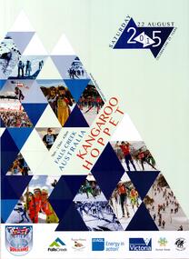
Poster - Kangaroo Hoppet 2015
The Kangaroo Hoppet is Australia’s premier long distance cross country ski race, and a member of the Worldloppet series of international cross country ski events. The first race at Falls Creek was held in 1979 under the name of “Australian Birkebeiner”. It was a 21km race with about 80 participants organised by the Birkebeiner Nordic Ski Club of Mount Beauty. The course started and finished at Falls Creek Alpine Resort and took participants out into the Bogong High Plains. After running the event for 10 years, it was decided they should become part of the Worldloppet series of marathon ski races. Representatives from the Birkebeiner Nordic Ski Club and the Australian Ski Federation attended the Worldloppet Annual Meeting in Finland in June 1990 to put the case for the acceptance of an Australian event into the Worldloppet series. Before being admitted, they had to demonstrate that the Birkebeiner Club could run a world class event, so three months later in August 1990 a 42km event named the Australian International Ski Marathon was held at Falls Creek together with a 21km Birkebeiner race and a 7km event called the Birkebeiner Lite. The event was approved by delegates from USA, Norway and Austria, in 1991 Australia became the 12th member of Worldloppet, with the condition that there had to be a name change. After some late night discussion allegedly involving red wine from North East Victoria the main event became the 42km Kangaroo Hoppet, with the minor events being the 21km Australian Birkebeiner, and 7km Joey Hoppet. In the winter of 1991, the first Kangaroo Hoppet was held. It was a great success and has been a regular fixture on the international ski calendar ever since. It features the main 42km event as well as a 21km event and a 7km event. The Hoppet brings the Australian snowfields to an international audience. In 2015 the Men's Winner was Valerio Leccardi from Switzerland in a time of 01:31:10.910. The winner of the Women's event was Maria Graefnings of Sweden in a time of 01:39:05.63. Due to the thick fog and extremely poor visibility, the course was shortened to two 18km laps to avoid the open areas of the Park and Heathy Spur.This poster is significant because it documents an event which brings international attention to Falls Creek and the surrounding region.A poster featuring a diamond pattern containing images of skiers. The date of the event is contained in two linked diamonds in the top right hand corner. Logos of AGL, Falls Creek All Season Alpine Resort, Alpine Shire, Tourism Victoria, Parks Victoria and the Birkebeiner Nordic Ski Club are across the bottom of the poster.Top Right: Saturday 22 August 2015 CELEBRATING 25 YEARS Within the diamond shapes: 7 km - 21km - 42 km FALLS CREEK AUSTRALIA KANGAROO HOPPET Below the skier: www.hoppet.com.au kangaroo hoppet, worldloppet events, falls creek, mt. beauty -
 Falls Creek Historical Society
Poster - Kangaroo Hoppet 2018
The Kangaroo Hoppet is Australia’s premier long distance cross country ski race, and a member of the Worldloppet series of international cross country ski events. The first race at Falls Creek was held in 1979 under the name of “Australian Birkebeiner”. It was a 21km race with about 80 participants organised by the Birkebeiner Nordic Ski Club of Mount Beauty. The course started and finished at Falls Creek Alpine Resort and took participants out into the Bogong High Plains. After running the event for 10 years, it was decided they should become part of the Worldloppet series of marathon ski races. Representatives from the Birkebeiner Nordic Ski Club and the Australian Ski Federation attended the Worldloppet Annual Meeting in Finland in June 1990 to put the case for the acceptance of an Australian event into the Worldloppet series. Before being admitted, they had to demonstrate that the Birkebeiner Club could run a world class event, so three months later in August 1990 a 42km event named the Australian International Ski Marathon was held at Falls Creek together with a 21km Birkebeiner race and a 7km event called the Birkebeiner Lite. The event was approved by delegates from USA, Norway and Austria, in 1991 Australia became the 12th member of Worldloppet, with the condition that there had to be a name change. After some late night discussion allegedly involving red wine from North East Victoria the main event became the 42km Kangaroo Hoppet, with the minor events being the 21km Australian Birkebeiner, and 7km Joey Hoppet. In the winter of 1991, the first Kangaroo Hoppet was held. It was a great success and has been a regular fixture on the international ski calendar ever since. It features the main 42km event as well as a 21km event and a 7km event. The Hoppet brings the Australian snowfields to an international audience. In 2018 the Men's Winner was Valerio Leccardi from Switzerland in a time of 1:39:55. The winner of the Women's event was Barbara Jezersek of Australia in a time of 1:52:59. This poster is significant because it documents an event which brings international attention to Falls Creek and the surrounding region.A poster featuring an aerial view of a Hoppet event with smaller image in diamond shapes on the right. Logos of Worldloppet, AGL, Falls Creek, Alpine Shire Council, Victorian State Government, the Birkebeiner Nordic Ski Club and FIS are across the bottom of the poster. Text: KANGAROO HOPPET 25 August 2018 FALLS CREEK AUSTRALIA 7 km 21 km 42 km Beside the logos: www.hoppet.com.au kangaroo hoppet, worldloppet events, falls creek, mt. beauty -
 Falls Creek Historical Society
Booklet - Falls Creek High Altitude Training Centre
A part of a yearly marketing and information material promoting Falls Creek region for the summer holidays. This item is important as it documents seasonal activities at Falls Creek Alpine ResortA4 size flyer for Falls Creek High Altitude Training Centre. Illustration of man running marathon front on with blue scribbled background and green scribbled ribbon. Text underneath image with green diamond graphics with black illustrations of various activities. skiing, ski, falls creek, victoria, school holidays, winter, snow, winter sport, 1990s, marketing, graphic design -
 Eltham District Historical Society Inc
Book, A Review and Appraisal of the Diamond Creek to Ringwood Study, volume 2, working paper, by Loder and Bayly, 1979
... A Review and Appraisal of the Diamond Creek to Ringwood... and appraisal of the Outer Ring Road Study Diamond Creek to Ringwood... and appraisal of the Outer Ring Road Study Diamond Creek to Ringwood ...Volume 2: Working papers. This report is a review and appraisal of the Outer Ring Road Study Diamond Creek to Ringwood prepared for The Road Planning Liaison Committee by the Joint Road Planning Group for the The City of Doncaster & Templestowe and The Shire of Eltham by Loder & Bayly Planning & Engineering Consultants. "This paper attempts to set a framework for an evaluation of the recommended road link between Diamond Creek and Ringwood." Various perspectives are examined. Includes fold out maps.91 p, maps, 27 cm.melbourne ring road, roads, freeways -
 Eltham District Historical Society Inc
Book, The Road Planning Liaison Committee, Outer Ring Study, Diamond Creek to Ringwood: Environmental Effects Statement, July 1979
... Outer Ring Study, Diamond Creek to Ringwood: Environmental... Planning Liaison Committee. The Outer Ring Study, Diamond Creek ...Prepared by The Road Planning Liaison Committee. The Outer Ring Study, Diamond Creek to Ringwood was a long term planning study carried out under the direction of the Road Planning Liaison Committee for the Government of Victoria. .. The basic aim of the .. Study was to determine the most appropriate future road system in the area between Diamond Creek and Ringwood, consistent with local and regional concerns and the environment of the area, with a view to seeking an emendment to the Metropolitan Planning Scheme to preserve the option to implement an appropriate road system some time in the future if this was considered necessary.non-fictionPrepared by The Road Planning Liaison Committee. The Outer Ring Study, Diamond Creek to Ringwood was a long term planning study carried out under the direction of the Road Planning Liaison Committee for the Government of Victoria. .. The basic aim of the .. Study was to determine the most appropriate future road system in the area between Diamond Creek and Ringwood, consistent with local and regional concerns and the environment of the area, with a view to seeking an emendment to the Metropolitan Planning Scheme to preserve the option to implement an appropriate road system some time in the future if this was considered necessary.roads, freeways, melbourne ring road -
 Eltham District Historical Society Inc
Book, The Joint Road Planning Group, Outer Ring Study, Diamond Creek to Ringwood: Technical Report Transport and Economic Evaluation, July 1979
... Outer Ring Study, Diamond Creek to Ringwood: Technical.... The Outer Ring Study, Diamond Creek to Ringwood was a long term ...Prepared for The Road Planning Liaison Committee by The Joint Road Planning Group. The Outer Ring Study, Diamond Creek to Ringwood was a long term planning study carried out under the direction of the Road Planning Liaison Committee for the Government of Victoria. .. The basic aim of the .. Study was to determine the most appropriate future road system in the area between Diamond Creek and Ringwood, consistent with local and regional concerns and the environment of the area, with a view to seeking an emendment to the Metropolitan Planning Scheme to preserve the option to implement an appropriate road system some time in the future if this was considered necessary. This technical report discusses, in detail, the transport and economic aspects of the investigation.. the techniques used take into account the long term implications of a range of possible travel cost policies and options and land use strategies.non-fictionPrepared for The Road Planning Liaison Committee by The Joint Road Planning Group. The Outer Ring Study, Diamond Creek to Ringwood was a long term planning study carried out under the direction of the Road Planning Liaison Committee for the Government of Victoria. .. The basic aim of the .. Study was to determine the most appropriate future road system in the area between Diamond Creek and Ringwood, consistent with local and regional concerns and the environment of the area, with a view to seeking an emendment to the Metropolitan Planning Scheme to preserve the option to implement an appropriate road system some time in the future if this was considered necessary. This technical report discusses, in detail, the transport and economic aspects of the investigation.. the techniques used take into account the long term implications of a range of possible travel cost policies and options and land use strategies.melbourne ring road, roads, freeways -
 Greensborough Historical Society
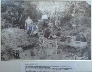
Photograph - Photograph (Framed), Early miners at work, 1850s
... diamond creek... possibly taken at Diamond Creek.... possibly taken at Diamond Creek. From the John Davidson collection ...Early miners at work caption reads: "The large bucket, called kibble, is used to pull up the unwanted debris, the smaller iron buckets are used to raise the alluvial material containing gold. This material is mixed with water in the puddling barrells (foreground) and poured into the cradle (left). The rocking motion causes the gold specks to sink to the bottom from where it is collected. The remaining material may then be hand washed in the gold pan held by the miner." This photograph possibly taken at Diamond Creek.From the John Davidson collection.Photograph in black plastic frame with typed caption on matte.john davidson, diamond creek, gold miners, mines and mining -
 Greensborough Historical Society
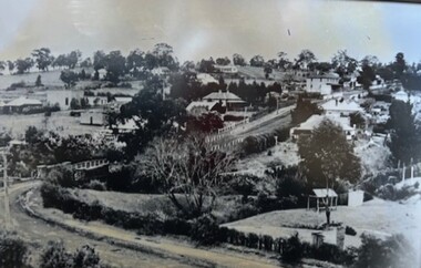
Photograph - Photograph (Framed), Greensborough from Diamond Creek Road
... Greensborough from Diamond Creek Road...Greensborough from Diamond Creek Road, includes a view... Diamond Creek Road, black and white....Greensborough from Diamond Creek Road, includes a view ...Greensborough from Diamond Creek Road, includes a view of lower Main Street and lower parkFrom the John Mackey collection. this item was displayed at the offices of Ryan, Mackey and Kelly, solicitors, Main Street Greensborough.Timber-framed photograph of view of Greensborough from Diamond Creek Road, black and white.greensborough, john mackey, blue stone bridge, marble hall -
 Eltham District Historical Society Inc
Photograph - Digital Photograph, Alan King, Reid family graves, Arthurs Creek Cemetery, 30 March 2008
... with Linton near Ballarat, the cemetery was renamed the Arthurs Creek... with Linton near Ballarat, the cemetery was renamed the Arthurs Creek ...The Arthurs Creek Cemetery was originally the private cemetery of pioneers Agnes and Patrick Reid. Published: Nillumbik Now and Then / Marguerite Marshall 2008; photographs Alan King with Marguerite Marshall.; p11 The Hazel Glen property, at Middle Hut Road, Arthurs Creek, which includes one of Victoria’s earliest pioneer buildings, was the forerunner to the Arthurs Creek and Doreen townships. At one time the Doreen Post Office and school were called Hazel Glen. The Hazel Glen State School No 945, before it was moved to its present site, stood on land to the south of Chapel Lane, which had been donated by Hazel Glen owner, William Reid. In May 1895 the post office was renamed Doreen to avoid confusion with the Reid’s address. The Arthurs Creek Cemetery was originally the private cemetery of Hazel Glen pioneers Agnes and Patrick Reid. The Reids with their eight children, arrived in Melbourne in April 1839. In 1844 Patrick Reid took over the licence to the Stewart Ponds run of 5120 acres (2072ha). Reid renamed it Hazel Glen, after Hazelden, the name of the Reid estate at Mearns in Renfrewshire, Scotland. Reid built a small cottage from local stone and hand-made bricks, with walls one yard (91 cm) thick, a flagstone floor and a shingle roof. Today two rooms and a store room survive as part of a larger house. Agnes died in 1847 aged 49, and was buried on a hill overlooking Hazel Glen, where it is said she had asked to be buried as it had been a favourite picnic spot.2 In 1858 Patrick died aged 74, and was buried near her. Their son William was to become Whittlesea Shire’s first president. From 1868 he was a Whittlesea Roads Board member, then a shire councillor until shortly before his death in 1923 aged 88. In 1865 the Reid’s burial area was no longer on their property, so it was declared a cemetery site. In 1867 it became the Linton Public Cemetery, being in the Linton Parish. However, to avoid confusion with Linton near Ballarat, the cemetery was renamed the Arthurs Creek Public Cemetery in 1926. Arthurs Creek was named after Henry Arthur, a pastoralist and public servant, who ran 1000 sheep lower down the Creek, from 1836 to 1841. It is believed he built his home at the end of today’s Challenger Street in Diamond Creek.This collection of almost 130 photos about places and people within the Shire of Nillumbik, an urban and rural municipality in Melbourne's north, contributes to an understanding of the history of the Shire. Published in 2008 immediately prior to the Black Saturday bushfires of February 7, 2009, it documents sites that were impacted, and in some cases destroyed by the fires. It includes photographs taken especially for the publication, creating a unique time capsule representing the Shire in the early 21st century. It remains the most recent comprehenesive publication devoted to the Shire's history connecting local residents to the past. agnes reid, arthurs creek cemetery, nillumbik now and then (marshall-king) collection, patrick reid, reid family -
 Eltham District Historical Society Inc
Photograph - Digital Photograph, Alan King, Golden King Mine poppet-head, Yarrambat Primary School, 1 February 2008
... , on the Greensborough–Diamond Creek Road. An annual agricultural show in Diamond..., on the Greensborough–Diamond Creek Road. An annual agricultural show in Diamond ...The Golden King Mine poppet-head stands at the school’s Yan Yean Road exit gate. Published: Nillumbik Now and Then / Marguerite Marshall 2008; photographs Alan King with Marguerite Marshall.; p23 Early Yarambat - Tanck's Corner Its early settlers, who in the 1840s were amongst the first non-Aboriginal people in the area, found life tough as they grazed their sheep and cattle. Yarrambat was then known as Tanck’s Corner or Reynolds Corner, after wood carter, Frederick Tanck, who owned land north of Ironbark Road, at the corner of Yan Yean Road, and Thomas Reynolds, owner of the opposite property. After Reynolds sold his land, the corner became known as Tanck’s Corner. In 1929 the district’s name was changed to Yarrambat, believed to mean ‘high hill’ in the Wurundjeri language. Tanck’s Corner was in the centre of gold-bearing country and the district is honeycombed with old tunnels and shafts. However although gold played a dominant role for decades, there was insufficient to develop a substantial township. Meat and agricultural produce made a greater impact. Until the mid-20th century the only substantial building was the primary school. The first gold rush occurred around 1860, the second after 1900; then during the Depression, the Government paid men to pan for gold. The first rush attracted hundreds of Chinese people to Smugglers Gully, who constructed round diggings to keep away spirits. Alluvial miners lived along the Plenty River in tents or humpies - some fenced with gardens - and some miners distilled their own ‘plonk’. It was a wild time and bushrangers - and later gangster Squizzy Taylor - were said to hide4 in the old Pioneer Tunnel in Dunne’s Gully between Heard Avenue and Pioneer Road. Mines opposite Tanck’s Corner included Beer’s Line, Golden Crown and Golden Stairs. Some of the big mines had batteries and stampers to process quartz. At first there was plenty of alluvial gold, as much as two ounces to the ton. At times gold was exposed after heavy rains so fossickers panned for gold around orchard irrigation trenches. Gold was mined until 1984 when Yarrambat’s last operating goldmine, the Golden King Mine, in North Oatlands Road, closed. The Clayton family operated it full-time, making a comfortable living and in the 1960s it was the only private family gold mine in Victoria.5 Gold was such an important part of Yarrambat’s history that a gold poppet-head is the Yarrambat Primary School’s logo. The Golden King Mine poppet-head stands at the school’s Yan Yean Road exit gate. However this school was built in 1988. The original school No 2054, at the corner of Ironbark and Yan Yean Roads, was opened in 1878 and modified to its present form in the 1920s. In 2000 it was relocated to the Heritage Museum at Yarrambat Park.7 The school, whose first head teacher was Charles Planner, consisted of one room with a three-roomed residence. The school was also the community centre. On Saturday nights it was crammed for dances or euchre parties, community singing or other social events. On Sundays, services for different denominations took turns each week. However the school had its teething problems. Parents accused Charles Planner of neglecting his duties and the school closed several times. When it closed in 1892, only church services continued. Social activities moved elsewhere, such as the tennis club to the Stuchbery tennis court opposite. A sports day and woodchop on Boxing Day around 1900 was held at the Evelyn Hill Hotel, also called Evelyn Arms and Tunnel Hill Hotel, on the Greensborough–Diamond Creek Road. An annual agricultural show in Diamond Creek paraded through the town, and New Year’s Day picnics at the Yan Yean Reservoir included highland dancing and competitions. Also popular were the Indian hawkers who visited every three months, selling trinkets, clothing and other items. One called Jimmy ‘Allem dem Bedi’, gave presents and told stories, played draughts and sold delicious curries he cooked over his camp fire at night.This collection of almost 130 photos about places and people within the Shire of Nillumbik, an urban and rural municipality in Melbourne's north, contributes to an understanding of the history of the Shire. Published in 2008 immediately prior to the Black Saturday bushfires of February 7, 2009, it documents sites that were impacted, and in some cases destroyed by the fires. It includes photographs taken especially for the publication, creating a unique time capsule representing the Shire in the early 21st century. It remains the most recent comprehenesive publication devoted to the Shire's history connecting local residents to the past. nillumbik now and then (marshall-king) collection, golden king mine, tanck's corner, yarrambat primary school -
 Eltham District Historical Society Inc
Photograph - Digital Photograph, Marguerite Marshall, Eltham Lower Park, 20 April 2008
... the Diamond Creek to the Yarra River.1 Before European settlement... the Diamond Creek to the Yarra River.1 Before European settlement ...Originally a race course, the park has brought the community together with a variety of activities. Published: Nillumbik Now and Then / Marguerite Marshall 2008; photographs Alan King with Marguerite Marshall.; p45 Once used for horse racing, which attracted visitors from Melbourne, the Eltham Lower Park has brought the community together with a wide range of activities. Horse riding is now enjoyed as a recreation in the park as are other sports. The park also includes the Diamond Valley Railway miniature trains and a sanctuary for the rare and vulnerable Eltham Copper Butterfly. Eltham Lower Park, with other parks, forms an almost continuous green band from Eltham’s centre, along the Diamond Creek to the Yarra River.1 Before European settlement the Wurundjeri people met on this land, particularly at the junction of the Diamond Creek with the Yarra River, which they called Birr-arung. This is commemorated by the sculpture, Not just a Pretty Place by Aleks Danko, winner of the 2000 Nillumbik Art in Public Places Award. The first European to settle here was probably Henry Foley, who in 1841 used it as part of his pastoral run. Foley sold his leasehold to Joseph Wilson in 1845, who soon after sold it to Frederick Falkiner. During the 1840s the future park was part of a government square mile (2.6 sqkm) reserve, north of the Yarra, within the Parish of Nillumbik, later named Eltham. Soon the land was used for horse racing after nearby residents cleared ten acres (4ha) in the early 1850s. A three-quarter of a mile (1.2km) race secured the winner the £10 Publican’s Prize. In response to popular demand, the newly formed Eltham District Road Board petitioned the Surveyor General of the Colony of Victoria, in 1856, for 36 acres (14.6ha) of crown land for a racecourse and recreation. By 1858 the Eltham races had become an institution. ‘Many skirmishes occurred and the way home was paved with temptation, with sly-grog for sale.3 In the early 1870s, two jockeys were sons of the police officer in charge of the Eltham Police Station, Miles S Lyons. Another ten acres (4ha) was added to the area in 1866 and 12 acres (4.8ha) – Hohnes Hill – in 1870. In 1866, two acres (0.8ha) on the creek banks became an animal pound with William Walsh the pound keeper in 1870, but this was later incorporated into the park. By 1877 the area was called a public park but horse racing and training continued into the 1920s. In the mid-1900s trotters were trained on a circuit road. In 1953 the Eltham Pony Club was established and used a cross-country course on Hohnes Hill. From the mid 1950s the club held the Eltham Easter Fair at the park, later to include a procession along Main Road from the town centre to the park. The park also attracted picnic parties and campers from the inner suburbs as did Wingrove Park, and businesses catering for visitors, sprang up on the opposite side of Main Road. Bus-loads of school children visited the park for Gould League bird days in the 1960s. In 1979 the Eltham Shire Council bought Lenister Farm, linking the park with the Yarra River. The Lenister Farm wetland includes a bird hide, viewing platform and interpretive signs.5 Pioneer Henry Stooke, later Road Board chairman, bought the 11 acres (4.5ha) - later to become Lenister Farm - from the Crown in 1862. Stooke never lived on this site and the two houses at Lenister Farm were built in the 20th century. Since its formation in 1871, the Council has controlled this crown land, which it named Eltham Park. But in the 1920s Eltham Council bought land near the town centre for a park, which it named Eltham Central Park. To avoid confusion the Council renamed Eltham Park, Eltham Lower Park. Since 2004 the Yarra footbridge has linked the park with the Yarra Valley Metropolitan Park and the Main Yarra Trail.This collection of almost 130 photos about places and people within the Shire of Nillumbik, an urban and rural municipality in Melbourne's north, contributes to an understanding of the history of the Shire. Published in 2008 immediately prior to the Black Saturday bushfires of February 7, 2009, it documents sites that were impacted, and in some cases destroyed by the fires. It includes photographs taken especially for the publication, creating a unique time capsule representing the Shire in the early 21st century. It remains the most recent comprehenesive publication devoted to the Shire's history connecting local residents to the past. nillumbik now and then (marshall-king) collection, eltham lower park, eltham park -
 Greensborough Historical Society
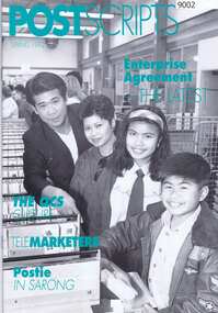
Magazine, Australia Post, Postscripts Spring 1992, 1992
... Diamond Creek Post Office... includes an article on Diamond Creek Post Ofice. ... includes an article on Diamond Creek Post Ofice. Diamond Creek Post ...The Australia Post Staff Journal contains work-related articles on postal services throughout Victoria. This edition includes an article on Diamond Creek Post Ofice. 32 p. magazine with black and green text and black and white photographs.diamond creek post office, postal services, australia post -
 Eltham District Historical Society Inc
Photograph - Digital Photograph, Marguerite Marshall, One Tree Hill Mine, Smiths Gully, 8 June 2006
... ) and Diamond Creek. There were also poorer bearing fields in Kangaroo...) and Diamond Creek. There were also poorer bearing fields in Kangaroo ...Gold was discovered on One Tree Hill in 1854. The site has been worked intermittently until fairly recent times. Published: Nillumbik Now and Then / Marguerite Marshall 2008; photographs Alan King with Marguerite Marshall.; p53 Though still a working mine, One Tree Hill Mine at Smiths Gully, now stands in a tranquil reserve surrounded by bush and native animals - in contrast to its heyday. In the mid 19th century, when the mine was part of the Caledonia Goldfields, hundreds of men in search of their fortune worked the alluvial gold in the Yarra River, its tributaries and the reefs that made up the goldfields. Miner Stan Bone, assisted by Wilfred Haywood, is the last of the independent gold miners in the area and still uses the quartz crushing battery as miners did when gold was first discovered in the area in 1851.1 Stan, who is the last of six generations of miners in his family, was aged 17 when he began mining on his father Alex’ mine, The Golden Crown in Yarrambat. These days, after blasting the gold-bearing rock in Mystery Reef, one of the four reefs at One Tree Hill, Stan transports it around five kilometres by tip truck to the Black Cameron Mine for crushing. There he uses water from the waterlogged mine, (which still contains gold), as the Happy Valley Creek at One Tree Hill is usually dry.2 The One Tree Hill Mine has been worked for close to a century since it opened around the late 1850s.3 The Swedish Reef was its most productive reef and one of the largest in the area. Around 1859, extractions included 204 ounces (5.8kg) of gold, won from 57 pounds (26kg) of stone.4 Then during World War Two, Stan’s uncle, Bill Wallace, and Alex Bone, closed the mine. In 1973, Stan, with his Uncle Bill, reopened the Black Cameron Mine and worked there until 1988. Stan resumed mining One Tree Hill in 1998. As late as the 1920s gold was picked up by chance! When crossing a gully on his way to vote at the St Andrews Primary School, Bill Joyce picked up some quartz containing gold. This site was to become the Black Cameron Mine. The Caledonia Diggings, named after Scotland’s ancient name by local Scots, began around Market Square (now Smiths Gully) and included Queenstown (St Andrews), Kingstown (Panton Hill) and Diamond Creek. There were also poorer bearing fields in Kangaroo Ground and Swipers Gully (now Research). * None of these compared in riches to the Ballarat and Bendigo fields5, but the Caledonia Diggings continued intermittently for close to 100 years. Gold was discovered in Victoria following a bid to stem the disappearance of much needed workmen to the New South Wales diggings. Several businessmen offered a reward of £200, for the discovery of gold within 200 miles (322 km) of Melbourne. Late in June 1851, gold was first discovered at Andersons Creek, Warrandyte. Then in 1854, George Boston and two other men discovered gold at Smiths Gully. Gold transformed the quiet districts, with a constant flow of families and vehicles on the dirt tracks en route to the Caledonia Diggings. Three thousand people worked the gullies in Market Square, including about 1000 Chinese miners. The square established its own police, mining warden, gold battery, school, shops and cemetery and grog flowed. Market Square flourished until the middle 1860s. Bullocks transported quartz from the Caledonia Goldfields to the crushing machinery at the Queenstown/St Andrews Battery, near Smiths Gully Cemetery. It was destroyed by bushfire in 1962. By the late 1850s, most early alluvial fields were in decline, but minor rushes continued until around 1900 and some until the early 1940s. Some miners did well, although most earned little from their hard labour in the harsh and primitive conditions.6 But according to historian, Mick Woiwod, the gold fields helped to democratise society, as individuals from all walks of life were forced to share experiences, and the ability to succeed, depended less on inherited wealth or social rank.This collection of almost 130 photos about places and people within the Shire of Nillumbik, an urban and rural municipality in Melbourne's north, contributes to an understanding of the history of the Shire. Published in 2008 immediately prior to the Black Saturday bushfires of February 7, 2009, it documents sites that were impacted, and in some cases destroyed by the fires. It includes photographs taken especially for the publication, creating a unique time capsule representing the Shire in the early 21st century. It remains the most recent comprehenesive publication devoted to the Shire's history connecting local residents to the past. nillumbik now and then (marshall-king) collection, gold mining, one tree hill mine, smiths gully -
 Eltham District Historical Society Inc
Photograph - Digital Photograph, Alan King, Ellis Cottage, Diamond Creek, 23 January 2008
... Ellis Cottage, Diamond Creek...Diamond Creek... pioneers of the Diamond Creek district and the benefactors... pioneers of the Diamond Creek district and the benefactors ...Built by William Ellis in 1865 of local uncut stone about 30cm thick, the cottage is now a museum and home to the Nillumbik Historical Society. Ellis Cottage is historically significant for its association with the Ellis family, who were pioneers of the Diamond Creek district and the benefactors of the notable Nillumbik Cemetery gateway. It illustrates the development of farming in the area. Ellis Cottage is historically and technically significant for its rare use of uncut local stone for building purposes. Covered under Heritage Overlay, Nillumbik Planning Scheme. National Estate Published: Nillumbik Now and Then / Marguerite Marshall 2008; photographs Alan King with Marguerite Marshall.; p79 Ellis Cottage, built by William Ellis, is a memorial to the courage of pioneers in the Diamond Valley area.1 Now a museum and home to the Nillumbik Historical Society, it is a fine example of an early settler’s house in Diamond Creek – and one of the few original buildings standing from the middle of the 19th century. It is a poor man’s cottage – typical of the dwellings of those who had to work hard to wrest a living in this district, because most of the land was not fertile enough for major forms of farming. The pretty stone cottage at 10 Nillumbik Square, built in 1865, is made of local uncut stone about one foot (30 cm) thick. It once stood near the centre of the 147 acres (59.4ha) Ellis bought in 1850. The property extended from Diamond Creek to Reynolds Road and from Perversi Avenue to the Wattle Glen School. It stood in the electoral parish of Nillumbik. The Nillumbik township (later called Diamond Creek) was not created until 1867. In 1912 the property was cut in half by the new railway to Hurstbridge. Ellis paid £147/10/- for the land - about three times what a Victorian farmer would usually earn in a year. Despite the poor quality soil Ellis became a very successful farmer with an orchard, vegetables and a dairy herd. Five years later, in 1855, Ellis bought 70 acres (28.3ha) from neighbour, Hugh Larimour. In 1857 Ellis bought 208 acres (84ha) at Yarra Glen. In 1877 he bought 122 acres (49.3ha) at Diamond Creek and later bought land at Greensborough and Woodstock. Ellis was born in 1815 at Blackawton, a small Devonshire village, and became a tenant farmer. It is not known why Ellis came out to Australia or settled in Diamond Creek. In 1847 he married Margaret Child at the Melbourne Presbyterian Church. Ellis and Child had no children and 18 years after the wedding, while probably living in Kangaroo Ground, Ellis built this small cottage. The simple cottage has a central hall and two rooms on each side. To maximise the small space the ceiling cavity was designed large enough to provide sleeping accommodation accessed via a ladder. Each room was heated by an open fireplace and the one in the kitchen was large enough to roast a sheep. A large cellar under the front room probably stored farm produce. Water came from a well as reticulated water did not arrive at Diamond Creek until 1914. In 1870 Ellis’ 22 year-old nephew Nathaniel joined him from England.2 Until 1890 they developed Ellis Park, praised in The Evelyn Observer, May 30,1890 as a model farm. Ellis had become wealthy, and on his death in 1896 his estate was valued at £9000. In his will he left £100 to construct memorial gates at the Nillumbik Cemetery where he was buried.3 Ellis left the farm to his second wife Louisa. As he had no children, upon her death the farm passed to Nathaniel, but he did not take it up. The farm was sold and leased several times until 1967, when engineer Phillip Lovitt bought the property and carried out major structural works. The Shire of Diamond Valley bought it in the 1980s and in 1989 restored it with the Nillumbik Historical Society. The stone walls of the cottage had been plastered with mud and straw mortar, which were removed as they were riddled with vermin. Doors, windows and a floor were replaced and the original roof of timber shingles had been replaced with slate. The well was too deeply cracked to be restored, so was used for a flower bed. Two mature Italian Cypresses at the entry are also heritage protected as they relate to similar trees planted at Shillinglaw Cottage and other early buildings in Nillumbik Shire.This collection of almost 130 photos about places and people within the Shire of Nillumbik, an urban and rural municipality in Melbourne's north, contributes to an understanding of the history of the Shire. Published in 2008 immediately prior to the Black Saturday bushfires of February 7, 2009, it documents sites that were impacted, and in some cases destroyed by the fires. It includes photographs taken especially for the publication, creating a unique time capsule representing the Shire in the early 21st century. It remains the most recent comprehenesive publication devoted to the Shire's history connecting local residents to the past. nillumbik now and then (marshall-king) collection, ellis cottage, diamond creek, nillumbik historical society, william ellis -
 Eltham District Historical Society Inc
Photograph - Digital Photograph, Alan King, Edendale Farm Homestead, 29 January 2008
... and the Diamond Creek. The homestead on the property was built in 1896... and the Diamond Creek. The homestead on the property was built in 1896 ...Edendale Farm is Nillumbik Shire Council's environment centre situated in Gastons Road, Eltham between the railway and the Diamond Creek. The homestead on the property was built in 1896 and is of historical significance, being the subject of a Heritage Overlay under the Nillumbik Planning Scheme. The Edendale property was originally part of an extensive land purchase in 1852 from the Crown by pioneer Eltham farmer Henry Stooke. He initially purchased 51 acres and later expanded his holdings by purchasing another three adjacent Crown allotments extending northerly from Josiah Holloway's Little Eltham subdivision. Despite clearing the land, Stooke did not build on this property, choosing to live on his property "Rosehill" at Lower Plenty. In 1896 Thomas Cool, Club Manager of the Victoria Coffee Palace in Melbourne purchased 7 acres of the original Stooke land and built the house now known as Edendale. Cool did not farm the land, instead using it as a gentleman’s residence, retiring to Eltham at weekends. In 1918 he purchased an additional 7 acres but in 1919 he sold the property. Later owners included J.W. Cox, the Gaston family and D. Mummery. In the 1980s the Eltham Shire Council purchased the site for use as a Council depot, but this use did not proceed. Subsequently, it was used as the Council pound. The Edendale Farm Pet Education and Retention Centre was established in the summer of 1988/1989 and was set up to replace the existing dog kennels with a high standard pet retention centre. The design style of the building was established to compliment the features of the existing house. It was equipped with 10 retention pens, a veterinary room and a pet education area where school children and other interested parties learnt about pet care procedures. It was later developed into a community farm and was run by an advisory committee and in 2000 it became an Environment Centre. In early 2006 an advisory committee was established for the development of a master plan for future development at Edendale Farm. The committee included Russell Yeoman, a former long-time shire planner and founding member of the Eltham District Historical Society. At the time of filming the Master Plan and future for Edendale was about continuing to develop Edendale as a centre of environment learning and looking at expanding displays and school program, running a lot more of life-long learning and workshops around sustainable living. Covered under Heritage Overlay, Nillumbik Planning Scheme. Published: Nillumbik Now and Then / Marguerite Marshall 2008; photographs Alan King with Marguerite Marshall.; p101 A sharp turn from busy Wattletree Road by the railway line, brings a surprise. Only 1.4 km from Eltham’s centre, sheep feed, blissfully unaware of the hectic suburban activity so close by. At the entrance to the 5.6ha Edendale Farm is another surprise. A work of art that looks like huge tree trunks transformed into bowler and top-hatted men. The Fences Act 1968 by Tony Trembath with Mark Cain and John Doyle, 1996, is classified by the National Trust of Australia as having Regional Significance. The title refers to a government act on disputes between neighbors over the placement of fences and boundaries. This takes a ‘wry swipe’ at a community divided by trivial squabbles. It also celebrates making do with limited resources.1 Further along on the left, the office wall is decorated with a massive Eltham Copper Butterfly, designed by Robert Tickner and made by school children with used plastic bottles and other waste material. Nillumbik Council runs Edendale as an Environmental Education Centre, to help preserve and enhance the local environment. As early as 1988 the former Eltham Shire Council realised Edendale’s importance in meeting people’s needs, particularly of children, to enjoy farmland. The centre, with the Eltham North Reserve to the north - including remnant bushland and open parkland - makes up the major part of the public open space for this area. The council considers this area will become increasingly important to the local community for recreational use.2 Educational programs aim to encourage community involvement to ensure the long-term rehabilitation and protection of natural bushland areas. Edendale is used by people of all ages - from school children to adults - for environmental programs and workshops, as well as for recreation, to enjoy the domestic animals and to picnic. Edendale is also home to the Environmental Works staff who manage reserves and roadsides and support Nillumbik Friends environmental groups. The Friends propagate plants at the nursery, which grows indigenous plants and sells these to the public.3 The centre demonstrates the sustainable living the farm teaches, with features like solar hot water and drive lighting and for the fireplace, logs of recycled cardboard. Edendale has had a varied history as a dog pound and even as a retreat for Thomas Cool, Club Manager of the Victoria Coffee Palace in Melbourne. His single-storey weatherboard house built in 1896, which still stands, was grander than most homes in Eltham. Although such buildings were common in many other parts of Melbourne, Eltham’s poverty and remoteness did not encourage such construction. The Victorian rectangular-shaped house, with a corrugated iron roof and veranda, has elegant large rooms, leadlight windows, ceiling roses, two bay windows and ornately carved wooden fireplace surrounds. Cool bought seven acres (2.8ha) from pioneer Eltham farmer Henry Stooke’s 200 acre (81ha) farm, which he had bought from the Crown in 1852. In 1918 Cool bought an extra seven acres (2.8ha) but in 1919 sold the estate to farmer John Cox. In 1933 Cox sold Edendale to Mrs Elizabeth Gaston, after whom the road leading to the centre was named. The property was owned by several Gaston family members, who called it Edendale, then by a police constable, Douglas Mummery, until the Shire of Eltham bought it in 1970. Oddly Edendale was known as Mummery’s for almost 20 years, although Mummery owned it only for a short time.4 The shire used Edendale as a dog pound until amalgamation with other municipalities in 1996. The pound then moved to the Yan Yean Road, Plenty site, which had been used by the former Diamond Valley Shire Council. To the west and north the centre is bounded by Diamond Creek and on the east by the Melbourne-Hurstbridge railway line. Part of the Research creek forms the centre’s southern boundary.This collection of almost 130 photos about places and people within the Shire of Nillumbik, an urban and rural municipality in Melbourne's north, contributes to an understanding of the history of the Shire. Published in 2008 immediately prior to the Black Saturday bushfires of February 7, 2009, it documents sites that were impacted, and in some cases destroyed by the fires. It includes photographs taken especially for the publication, creating a unique time capsule representing the Shire in the early 21st century. It remains the most recent comprehenesive publication devoted to the Shire's history connecting local residents to the past. nillumbik now and then (marshall-king) collection, edendale farm -
 Eltham District Historical Society Inc
Photograph - Digital Photograph, Alan King, Eltham Railway Trestle Bridge, 28 December 2007
... and Eltham up the Diamond Creek valley towards Queenstown... and Eltham up the Diamond Creek valley towards Queenstown ...Covered under National Trust of Australia (Victoria) State Significance and Heritage Overlay, Nillumbik Planning Scheme. Published: Nillumbik Now and Then / Marguerite Marshall 2008; photographs Alan King with Marguerite Marshall.; p103 The Eltham railway trestle bridge is the only one of its kind still regularly used in Melbourne’s metropolitan railway network. Opened in 1902, it is also one of Victoria’s very few timber rail bridges that still carries trains.1 The bridge is part of the railway line extension from Heidelberg - extended to Hurstbridge in 1912. This extension resulted in one of the greatest social changes experienced in Eltham Shire, as it considerably lessened its isolation attracting tourists, artists and suburban commuters particularly after World War Two.2 The bridge has been classified by the National Trust as historically, scientifically, aesthetically and socially significant at state level. But this has not always been recognised, and in 1977, locals fought to save it from destruction. The Victorian Railways proposed to replace the bridge with an earth embankment and large culverts to avoid maintenance problems and fire. This was rejected by the Eltham Council who protested that the bridge helped maintain the area’s rural character, historic link and beauty, as well as avoiding possible serious flooding on the flood plain if a culvert was blocked. The bridge stands as part of a National Trust classified landscape which includes the Alistair Knox Park, named after the local conservationist and architect who helped to make Eltham famous for its mud-brick houses. The landscape includes tall and spreading manna gums and candlebarks, and the historic Shillinglaw Cottage. Artist Walter Withers, one of the Heidelberg School of painters, painted the bridge early in the 20th century. The 38 span single-track railway bridge over creek and road has 34 timber-beam spans and four steel-joist spans, supported by four-pile timber piers and timber abutments. It has almost 200m of timber deck. All of the timbers have been replaced over the years, but the only change to the bridge’s character was the addition of pylons and wiring for electric trains in 1923. A petition for a railway to the shire was first made in 1883. A large deputation of local citizens to the Commissioner of Railways proposed a route passing through Alphington to midway between Greensborough and Eltham up the Diamond Creek valley towards Queenstown and Kinglake. As a result the Princes Bridge-Heidelberg Railway was opened in 1888. From 1888 locals demanded a railway extension. Kangaroo Ground farmers in particular, led by Shire Councillor and Member for Evelyn, Ewen Cameron, said it would assist local farmers and orchardists send their produce to the Melbourne market. In 1890, before the severe economic Depression, an extension of the line to Hurst’s Bridge (now Hurstbridge) was included in a new Railways Bill. The parliamentary delegations were regaled with a banquet at Hurst’s barn and entertained by the Diamond Creek Brass Band, but the extension was abandoned when the Depression struck in 1892-1893. The extension of the railway to Eltham, completed in 1902, was one of the few built in those hard times. That is why the Eltham timber-trestle railway bridge is a rare example of a broad-gauge rail bridge constructed between 1893 and 1910. At the opening, despite persistent drizzle, 300 children waving flags and banners were among the large crowd welcoming the first train, carrying official dignitaries, to Eltham. It had taken 24 years to bring the railway to Eltham. From then Eltham became a popular destination for outings. Mr Orford of Eltham recalled that after the railway came to Eltham ‘the craze for picnics on weekends and holidays began…. During the wattle season, wattle trains came to Eltham frequently. The visitors roamed the creek pulling great armfuls of wattle blossom to take back with them to Melbourne’.3 In 1926 the railway line was electrified as part of the metropolitan rail network. But the Victorian Railways decided not to complete the formerly planned Diamond Valley Railway to Queenstown (now St Andrews) and Kinglake.This collection of almost 130 photos about places and people within the Shire of Nillumbik, an urban and rural municipality in Melbourne's north, contributes to an understanding of the history of the Shire. Published in 2008 immediately prior to the Black Saturday bushfires of February 7, 2009, it documents sites that were impacted, and in some cases destroyed by the fires. It includes photographs taken especially for the publication, creating a unique time capsule representing the Shire in the early 21st century. It remains the most recent comprehenesive publication devoted to the Shire's history connecting local residents to the past. nillumbik now and then (marshall-king) collection, eltham railway trestle bridge, eltham trestle bridge -
 Eltham District Historical Society Inc
Photograph - Digital Photograph, Alan King, Monash Bridge, Hurstbridge, 23 January 2008
... Monash Bridge spans the Diamond Creek at Hurstbridge...Monash Bridge spans the Diamond Creek at Hurstbridge ...Monash Bridge spans the Diamond Creek at Hurstbridge. It was built in 1917 for the Shires of Heidelberg, Eltham and Whittlesea. It is considered Nillumbik Shire's finest engineered bridge and was construced by the engineering company of Sir John Monash. Covered under Heritage Overlay, Nillumbik Planning Scheme. Published: Nillumbik Now and Then / Marguerite Marshall 2008; photographs Alan King with Marguerite Marshall.; p117 Monash Bridge is considered the Shire’s finest engineered bridge and was constructed by the engineering company of that great Australian, Sir John Monash.1 The bridge spans Diamond Creek on the Hurstbridge-Arthurs Creek Road, linking Hurstbridge with Yarrambat and Arthurs Creek. Monash Bridge, also called Hurst’s Bridge, was built in 1917, by the Reinforced Concrete and Monier Pipe Construction Company Pty Ltd, for the Shires of Heidelberg, Eltham and Whittlesea. Although Monash was probably in action overseas during World War One when the bridge was designed and constructed, he evolved the basic design in the 1900s and it was a standard design for the firm. However J A Laing, a designer at the firm, was probably the designer, as his initials are on bridge drawings held by the Eltham District Historical Society.2 The bridge is an excellent early Australian example of an open spandrel reinforced concrete arch bridge and has a single span of 29 metres. It is unusual in Victoria, but similar to many reinforced concrete arch bridges in Europe and America, built from the late 19th century. In Victoria, Monash pioneered the use of reinforced concrete – then a revolutionary construction material. His company, Monash & Anderson, had the exclusive licence for the Monier patent for the system of reinforced concrete construction for Victoria and New South Wales. A well-known example of the Monier arch bridge is the Morell Bridge in South Yarra. The sweeping arch of the Monash Bridge combines grace and utility and blends with the surrounding rural landscape. Its design and construction have allowed it to carry increasing volumes of heavy traffic, but in modern times the one lane is considered by some to prevent easy passage through Hurstbridge. However others consider this an asset to deter too much more traffic, which would diminish Hurstbridge’s charming rural character.3 This is the third bridge across the Diamond Creek at this site. The original bridge was a log bridge upstream, constructed in the 1850s by early settler, Henry Hurst, after whom Hurstbridge was named. The bridge spanned the creek, where it divided his family’s property. In the 1880s a timber bridge replaced it, known as Hurst’s Bridge. However a more permanent bridge was considered necessary when the new railway arrived in 1912, bringing with it expectations of growth in the town and the surrounding fruit-growing district. Monash Bridge’s official opening on November 3, 1917 was a gala occasion, which took place before about 1000 spectators. Two who attended the opening had a particularly sound knowledge of the locality. One was Fred Hurst, Henry’s brother, who used to ford the creek at or near the bridge’s site more than 50 years before. The other was John McDonald of Arthurs Creek, who had built the old wooden bridge over the creek about 40 years earlier.4 Although John Monash was a fine engineer, his fame came from his brilliant war career, rather than from his engineering or his many other achievements. Monash was Corps Commander of the Australian Forces. His brilliance was recognised with his awards: Knight Grand Cross of the Order of St. Michael and St. George, and Knight Commander of the Bath. Monash was also decorated by the French, Belgian, and American Governments.5 After the war, Monash worked in many prominent civilian positions, the most notable as head of the Victorian State Electricity Commission. He was a leading and loved public figure, involved in many public and private organisations. He was president of the Australian Zionist Federation and involved in the Boy Scouts. Monash University is named after him. By the 1920s Monash was probably regarded as the greatest living Australian.6 Despite most of his life working as an administrator and leader, rather than a fighting soldier, he became integral to the ANZAC legend. Monash died in 1931.This collection of almost 130 photos about places and people within the Shire of Nillumbik, an urban and rural municipality in Melbourne's north, contributes to an understanding of the history of the Shire. Published in 2008 immediately prior to the Black Saturday bushfires of February 7, 2009, it documents sites that were impacted, and in some cases destroyed by the fires. It includes photographs taken especially for the publication, creating a unique time capsule representing the Shire in the early 21st century. It remains the most recent comprehenesive publication devoted to the Shire's history connecting local residents to the past. nillumbik now and then (marshall-king) collection, hurstbridge, monash bridge -
 Eltham District Historical Society Inc
Photograph - Digital Photograph, Marguerite Marshall, Alan Marshall by Marcus Skipper (1995) outside Eltham Library, Panther Place, Eltham, 11 October 2006
... , was buried in the Nillumbik Cemetery at Diamond Creek. Although..., was buried in the Nillumbik Cemetery at Diamond Creek. Although ...Sculture in bronze of Alan Marshall by Marcus Skipper, 1995 Alan Marshall, AM., O.B.E., Hon.LL,D. (1902-1984) was born at Noorat, Victoria and became one of Australia's most famous authors. His association with the Eltham area began in 1920 when he started his first job as a junior clerk at the Eltham Shire Offices, Kangaroo Ground. In the 1940's he spent some time living at Research. From 1955 he lived in Eltham for nearly 20 years. Disabilities resulting from polio as a young child did not prevent a wide range of experiences. Alan's occupations have been listed as clerk, night watchman, fortune teller, freelance journalist and author. He has been patron of many disadvantaged Children's Societies. Alan's books are numerous and include novels, short stories, children's books, history and travel. Among the best known are his autobiographies "I Can Jump Puddles" and "This is the Grass". Others include "These are My People", "Ourselves Writ Strange", "People of the Dreamtime"; "The Gay Provider" and "Wild Red Horses". In 1971 he wrote the Centenary History of the Shire of Eltham, "Pioneers and Painters". Covered under National Trust of Australia (Victoria), State significance. Published: Nillumbik Now and Then / Marguerite Marshall 2008; photographs Alan King with Marguerite Marshall.; p159 Outside the Eltham Library a bronze figure of a short one-legged man with a crutch invites people to the world of literature. The bronze statue, by Marcus Skipper, is of author Alan Marshall, who is famed for his autobiography I Can Jump Puddles, about growing up and overcoming the effects of polio. That plucky little boy later lived in the Nillumbik district for more than 50 years, and on his death in 1984, was buried in the Nillumbik Cemetery at Diamond Creek. Although a hugely successful author, his grave is modest with only a tiny boulder and simple bronze plaque on a grassed plot. From 1955 to 1972 Marshall lived in a tiny fibro-cement bungalow at the rear of a house at Park West Road, Eltham, owned by his older sister, Elsie McConnell. It was there that he wrote most of his autobiographical trilogy and his history of the former Eltham Shire, Pioneers and Painters. His long association with Eltham Shire began in 1918 when his family moved to Diamond Creek. Then in 1920 he began work as a junior clerk at the Eltham Shire Offices on Main Road, Kangaroo Ground near the Yarra Glen Road, while boarding at the hotel next door. Marshall later bought a block of land in Research, which had three bark huts. In one of these he wrote his first book These Are My People. He later sold the land but lived in a caravan there and in 1955 wrote I Can Jump Puddles.1 Proud of its citizen, the Eltham Shire named a park after Marshall at the corner of Main Road and Leanne Drive, Eltham. In 1985 the Shire initiated the Alan Marshall Short Story Award. It was Marshall’s early life in the country that taught him to live courageously in spite of his crippling polio, and he inspired many. This informed his writing – full of courage, championing the battler and love of the bush. Alan Marshall was born in 1902 at Noorat in Western Victoria, as the only son of Billy a drover, horse breaker, hawker and then general store owner. At the age of six, Marshall contracted infantile paralysis and was later hospitalised in Colac for 18 months. With his father’s encouragement, Marshall learnt to swim, wrestle and box, ride a bicycle (downhill), ride a horse and drive a car. Marshall won a scholarship to Stott’s Correspondence College to study accountancy. To help him continue his studies and find employment, his family bought 12 acres (4.8ha), in Ryans Road, Diamond Creek, opposite Windmill Court. There they ran cows, some poultry and an orchard. But life with a disability and during the Depression was hard for Marshall, who for 20 years, endured long periods of unemployment and loneliness and was often exploited at work.2 However, life improved in the 1930s, when he published short stories and articles in newspapers and magazines, including a column of advice to the lovelorn, which he wrote for nearly 20 years. At age 42 Marshall published his first book and in the next 30 years he published more than 20. His most successful book was I Can Jump Puddles, which sold more than three million copies internationally. It was made into a film, released in 1971, by Czechoslovakian director Karel Kachyna. Marshall was one of the first Australians to write about Aborigines who called him Gurrawilla - teller of tales - when he lived with them in Arnhem Land for eight months.3 In 1941 Marshall married Olive Dixon, with whom he had two daughters, Catherine and Jennifer. Marshall and Olive divorced in 1957. In 1972 Marshall was awarded an OBE for his work with the handicapped. He was also awarded an Honorary Doctor of Laws by Melbourne University, an Order of Australia for services to literature and the Soviet Order of Friendship of Peoples.This collection of almost 130 photos about places and people within the Shire of Nillumbik, an urban and rural municipality in Melbourne's north, contributes to an understanding of the history of the Shire. Published in 2008 immediately prior to the Black Saturday bushfires of February 7, 2009, it documents sites that were impacted, and in some cases destroyed by the fires. It includes photographs taken especially for the publication, creating a unique time capsule representing the Shire in the early 21st century. It remains the most recent comprehenesive publication devoted to the Shire's history connecting local residents to the past. nillumbik now and then (marshall-king) collection, alan marshall, art in public places, eltham, eltham library, marcus skipper, panther place, public art, sculpture -
 Eltham District Historical Society Inc
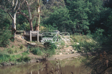
Slide - Photograph, Viewing platform near the confluence of Diamond Creek and Yarra River, c.Nov. 2001
... Viewing platform near the confluence of Diamond Creek and...diamond creek.... It is situated near Lenister Farm on the Diamond Creek trail.... It is situated near Lenister Farm on the Diamond Creek trail ...In October 1996 the viewing platform was opened. It is situated near Lenister Farm on the Diamond Creek trail. It was a joint project involving Nillumbik Shire Council, Skill Seekers Inc., Department of Natural resources and Environment and Department of Employment, Education, Training and Youth Affairs. The platform was officially opened by Don Cordell Chairman of Commissioners. Part of a slide show presentation "A Trip Down the Diamond Creek" by Russell Yeoman to the Eltham District Historical Society meeting of 14 Nov. 200135mm colour positive transparency Mount - Black and Whiteconfluence, diamond creek, yarra river, viewing platform -
 Eltham District Historical Society Inc
Photograph - Digital Photograph, Marguerite Marshall, Hawthorn hedges, Eltham-Yarra Glen Road, Kangaroo Ground, 3 October 2006
... and Diamond Creek. Until 1921, the Eltham-Yarra Glen Road beside... and Diamond Creek. Until 1921, the Eltham-Yarra Glen Road beside ...Hawthorn hedges are important reminders of Kangaroo Ground's Scottish heritage. They are Registered on the Victorian Heritage Register. They are "historically significant because the planting of hawthorn hedges reflects the adoption of Eurorpean farming techniques by the Kangaroo Ground population in the period following settlement and because the grid pattern of paddocks that the Hawthorn hedges define is very different to today's farm landscapes." Covered under Heritage Overlay, Nillumbik Planning Scheme. Published: Nillumbik Now and Then / Marguerite Marshall 2008; photographs Alan King with Marguerite Marshall.; p21 Hawthorn hedges bordering Kangaroo Ground’s gently rolling farmlands are important reminders of its Scottish heritage and are rare so close to Melbourne.1 As early as the 1840s newly arrived farmers from Scotland planted hawthorn hedges around their properties, to protect crops from the numerous kangaroos and wallabies. Many of these hedges survive today. These farmers had the good fortune to settle some of the most fertile land available for cropping in the Colony of Victoria. At that time the black volcanic soil could sustain an amazing two crops a year. By the mid 1850s, 500 acres (202ha) of wheat were growing in Kangaroo Ground. But the crops were threatened by kangaroos, which were so plentiful, that Surveyor-General, Robert Hoddle, named the district Kangaroo Ground in 1838. As post-and-rail fences proved inadequate barriers for the bounding kangaroos, the Scots planted hawthorn hedgerows as they had done in Scotland. Some also used the hedges to net birds, presumably for the table. Interestingly the farmers in the bordering townships of Panton Hill and Christmas Hills, did not plant hawthorn hedges around their properties. Perhaps it was because by the time they settled in the 1860s and 1870s most of the wildlife had been gunned down by residents.2 The canny Scots planted the hedges on public land outside their own farms, as the hedgerows could spread to about five yards (five m) in width. With this impenetrable barrier Kangaroo Ground’s industrious farmers flourished to gain the economic power that saw the Shire of Eltham governed from Kangaroo Ground for 79 years (1858-1937). The Scots jealously guarded their land, so hard to get in Scotland. That is why they refused to release any of it ‘for local roads to follow easier grades as was the case in surrounding districts where roads generally followed ridgelines or streams’.3 Instead the roads were built in accordance with the magnetic bearings of their first survey in 1847 whether that suited the steep topography or not. This could force traffic to diverge when wet through Greensborough and Diamond Creek. Until 1921, the Eltham-Yarra Glen Road beside Wellers Restaurant, ‘dipped down into the upper reaches of Stony Creek’.4 Later some corners were compulsorily cut for the increasing motor traffic. As late as the 1960s, corners were cut to form sweeping curves above and alongside the Kangaroo Ground Cemetery and opposite the Emergency Operations Centre. In the latter case, the farmers – understanding their hedgerows as important heritage – insisted upon their reinstatement to conform to the altered road alignment. Kangaroo Ground’s ancient manna gums also point to the district’s history and to that of the hedgerows. The Aboriginal people had transformed the original forests into grasslands with the fires they lit to attract kangaroos, (which the Scots were to exclude by planting hedgerows). But the Wurundjeri hunters left the gums (Eucalyptus vimminalis cygnetensis), on the grasslands as ‘stalking trees’ to hunt kangaroos. The hawthorn hedges in Kangaroo Ground were neglected for around 60 years from about the middle of the 20th century. Bushfires had created gaps and the hedgerows were not trimmed. Then in late 2005, local historian Mick Woiwod, formed a group to lobby the Nillumbik Shire to restore the hedges, which could last for many centuries. Some hedges in parts of Britain date back to AD 800.5 Although the original Scottish farmers have gone, the hedges are a reminder of when they flourished in the district, which has changed little in 150 years.This collection of almost 130 photos about places and people within the Shire of Nillumbik, an urban and rural municipality in Melbourne's north, contributes to an understanding of the history of the Shire. Published in 2008 immediately prior to the Black Saturday bushfires of February 7, 2009, it documents sites that were impacted, and in some cases destroyed by the fires. It includes photographs taken especially for the publication, creating a unique time capsule representing the Shire in the early 21st century. It remains the most recent comprehenesive publication devoted to the Shire's history connecting local residents to the past. nillumbik now and then (marshall-king) collection, eltham-yarra glen road, hawthorn hedgerow, kangaroo ground -
 Eltham District Historical Society Inc
Photograph - Digital Photograph, Alan King, Eltham Living and Learning Centre, 26 January 2008
... ) and stretching down to the Diamond Creek for £100. He contracted Benjamin...) and stretching down to the Diamond Creek for £100. He contracted Benjamin ...In 1857, tanner John Pearson purchased three and a half acres of land in Little Eltham, at the western end of Pitt Street, with a 70-foot frontage to Maria Street (Main Road) and stretching down to the Diamond Creek for £100. He contracted Benjamin Oliver Wallis to build house for him. Wallis, a mason by trade who originated from the Cornish village of Newlyn, migrated to Melbourne in 1853 and was shortly engaged by Richard Warren to build the Eltham Hotel, which opened in 1854. When Warren fell into financial difficulty in 1858, Wallis purchased the hotel. That same year, Pearson constructed a tannery below the house with access to the water in the Diamond Creek. When Pearson became bankrupt in 1867, Wallis similarly acquired the house from Pearson’s creditors in 1868 and lived there until his death in 1896. For some of this time the house was in the name of Wallis’s son Richard but following his death in 1888, ownership reverted to his father. It was purchased by retired teacher Richard Gilsenen in 1899. Gilsenen was made acting head teacher at the Eltham State School in 1906 following the sudden death of head teacher John Brown. In the 1950s the house was bought by retired engineer Dr Alfred Fitzpatrick and his wife Claire who made various modifications to house goats and poultry as well as structural modifications to the house. In the early 1970s, Eltham Shire Councillors Frank Maas and Don Maling proposed an extended communities’ activities program be set up and the Commonwealth Grants Commission was approached for financial assistance. In 1974 a $50,000 Commonwealth Grant was received by the Shire Council to acquire the Fitzpatrick property as part of the planning to establish an extended communities’ activities program. The Fitzpatricks moved next door and Claire taught at the new Living and Learning Centre, which began in 1975, one of the first community education centres in Victoria. Covered under Heritage Overlay, Nillumbik Planning Scheme. Published: Nillumbik Now and Then / Marguerite Marshall 2008; photographs Alan King with Marguerite Marshall.; p59 It’s a centre for sharing knowledge and friendship and it stands on the former hub of Eltham’s original township near Pitt Street. The Eltham Living and Learning Centre, with around 2000 participants a year, began in 1975 as one of the first Community Education Centres in Victoria. Classes ranging from macramé to wine making to environmental living have enriched the lives of thousands of people through the generosity of tutors sharing their skills free of charge. The centre’s heart is the brick cottage, built in 1858 by tanner John Pearson. He bought the three and a half acre (1.4ha) allotment fronting Maria Street (now Main Road) and stretching down to the Diamond Creek. The allotment formed part of a 316 acre (127.8ha) subdivision, owned by Josiah Holloway, called Little Eltham, north of the original Eltham Reserve.1 The allotment then passed through the hands of several speculators before it was sold to Pearson for £100 in 1857. Mr Pearson’s children attended the Eltham Primary School from 1864 to 1867. But creditors took possession of the property when his tannery folded in 1867. It was then sold to publican Benjamin Wallis, who owned the Eltham Hotel at the corner of Pitt Street and Main Road. In 1899 the property was bought by Richard Gilsenan, who became acting head teacher of the Eltham Primary State School in 1906. In the 1950s, retired engineer Dr Alfred Fitzpatrick and his wife Claire bought the property, and made structural changes. Claire, a journalist and community campaigner, modified and built pens for goats and poultry, a stable, a garage and planted fruit trees and a vegetable garden. In the early 1970s a young woman called Carina Hack approached Gwen Wesson at the Diamond Valley Learning Centre (Victoria’s first Community Education Centre) about starting a community centre. Following Wesson’s suggestion, Hack spoke to Shire President Alistair Knox ‘one bleak rainy afternoon, sipping hot drinks and discussing life’.2 Eltham Shire Councillors Frank Maas and Don Maling proposed a community activities program and the council received a $50,000 Commonwealth Government Grant for this venture.3 The Fitzpatricks sold their property to the council and moved next door and Claire taught at the new centre, which Hack named. Eltham obviously wanted such a centre as Hack recalls. ‘During the next two months we had about 50 volunteers working day, night and weekends, scrubbing down, plastering and painting walls, replacing floors, repairing fences, recycling furniture, sewing curtains and cushions, donating furniture, toys, equipment, clean-ing and gardening…’4 The first enrolment day saw a queue stretching up the driveway nearly to the gate and the first sessions attracted 270 people a week. Soon the outbuildings were converted into pottery studios and a large workshop. From 1979 the Eltham Art and Craft Market was held in the centre’s grounds and the Friends of the Centre ran it from 1980. A former program coordinator, Margaret Johnson, remembers enrolment day in the late 1970s and 1980s, when hundreds of people would queue – and some even camped overnight! Overnighters were greeted in the morning with fresh tea and toast. Another tradition was The Enrolment Day Cake with Recipe, given to volunteers. ‘One happy Enrolment Day fell on February 14 and let’s just say that St Valentine found some willing participants, paying $2 for a kiss.’5 Meanwhile the participants’ children could play at the Council Eltham Lower Park house in Hohnes Road, later in Susan Street. But the centre has had difficulties too. In 1990 a fire destroyed the stable and the police suspected arson. However the pavilion was built in its place.This collection of almost 130 photos about places and people within the Shire of Nillumbik, an urban and rural municipality in Melbourne's north, contributes to an understanding of the history of the Shire. Published in 2008 immediately prior to the Black Saturday bushfires of February 7, 2009, it documents sites that were impacted, and in some cases destroyed by the fires. It includes photographs taken especially for the publication, creating a unique time capsule representing the Shire in the early 21st century. It remains the most recent comprehenesive publication devoted to the Shire's history connecting local residents to the past. nillumbik now and then (marshall-king) collection, benjamin oliver wallis, claire fitzpatrick, don maling, dr alfred fitzpatrick, eltham living and learning centre, frank maas, john pearson, richard gilsenen, tannery -
 Eltham District Historical Society Inc
Photograph - Digital Photograph, Alan King, St Andrews Hotel, 2 February 2008
... Hill (formerly Kingstown), Research and Diamond Creek, from... Hill (formerly Kingstown), Research and Diamond Creek, from ...The c1860 St Andrews Hotel, with the c1930 additions, and the Canary Island Palm, and the surrounding site to the title boundaries are historically, socially and aesthetically significant to the Shire of Nillumbik. The St Andrews Hotel is historically significant because it may have given its name 'St Andrews' to the town (another suggestion is that the name came from St Andrews church) and for its connection to Ewen Hugh Cameron (1831-1915) the prosperous local farmer, member of the Eltham Roads Board/Shire Council and local MP. It is also significant as the oldest hotel building in the former Shire of Eltham, as one of the few surviving buildings connected with the Caledonian goldfields era and as one of a handful of early structures to have survived the 1960s bushfires; the additions and alterations to the hotel reflect its long life. The hotel is socially significant because it has served as an important meeting place for more than 160 years. The Canary Island Palm is historically significant as a rare example of exotic tree planting in this rural area. The tree is aesthetically and historically significant as a local landmark and for its contribution to the streetscape and landscape value. Covered under Heritage Overlay, Nillumbik Planning Scheme. Published: Nillumbik Now and Then / Marguerite Marshall 2008; photographs Alan King with Marguerite Marshall.; p71 Built around 1860, St Andrews Hotel has changed little since it first welcomed thirsty gold diggers from the Caledonia Goldfields. The timber building, with gabled roof, beamed ceilings and a massive fireplace, is Nillumbik Shire’s oldest hotel and has always been an important community centre, particularly in its early days. Fortunately, the hotel and the near-by Canary Island Palm Tree, which is quite rare in this area, survived the 1960s bushfires, along with a few other early buildings. St Andrews (formerly Queenstown) was founded on gold, as were Panton Hill (formerly Kingstown), Research and Diamond Creek, from the mid-1850s to the 1860s. But by the early 20th century common use changed the name Queenstown to St Andrews, possibly after this hotel or after the church or the mining district.1 The Caledonia Diggings were probably named by Scottish settlers after the Roman name for Scotland, despite this land bearing little similarity to their homeland.2 Queenstown, which was proclaimed as a township in 1861, was the gold-mining centre on the Upper Diamond and in the 1850s had up to 600 European inhabitants and a small camp of Chinese on the flats along the creek. Queenstown was the administrative centre of the Upper Diamond with three hotels, a brewery and a slaughterhouse.3 It is unclear which hotel was the district’s first, as distinct from the earliest unlicensed grog shops, some of which operated in tents. John Corke Knell was one of eight unlicensed storekeepers supplying drink to miners at Caledonia in 1857, named by Sgt. McNamara of the Caledonia Police Station.4 In February 1859, Knell apparently bought most of the present hotel’s site at the first township land sales. As he was a local storekeeper, he might have first established a store there.5 Knell and his wife Eliza were early licensees of the St Andrews Hotel. The hotel had eight bedrooms – including three for public use – and the dining-room seated 30 people. It is thought they named the hotel St Andrews after Eliza’s hometown of St Andrews in Scotland. St Andrews Hotel was an important local centre in several ways. In the same building the Knells also operated a post office and general store. In 1867 Mrs Knell was appointed Deputy Registrar of Births and Deaths for Queenstown. The hotel was also used to hold inquests into people’s deaths when the police residence became too small.6 The hotel also became a fashionable destination at Christmas for parties from Melbourne. In 1868, possibly following her husband’s death, Mrs Knell applied for a temporary licence, which was then transferred to Robert Smith after their marriage in 1869. But then, possibly after Robert’s death, Mrs Smith operated the hotel until 1892. This contradicts a report in The Evelyn Observer 1882 that JC Knells of the St Andrews Hotel was granted a publican’s licence in the Queenstown Police Court. At that time he was supposed to have been dead for around 14 years! Although Mrs Smith was a respected citizen, known for her geniality and as an ideal hostess, she had a minor brush with the law when she was fined ten shillings for not lighting a lamp outside her licensed premises.7 From 1892 several publicans owned the hotel including W Atkins, from 1895. In 1909 the licensee was apparently Mrs Smith’s son, Walter Knell, who held the licence until at least the 1920s. Not surprisingly, this old hotel has attracted romantic stories. Mrs Smith is said to be seen roaming the pub in her nightdress – even though she was buried in the Queenstown Cemetery in 1911.8 A musical The Hero of Queenstown, set in the hotel, was written and produced by local actor Reg Evans in the 1970s.This collection of almost 130 photos about places and people within the Shire of Nillumbik, an urban and rural municipality in Melbourne's north, contributes to an understanding of the history of the Shire. Published in 2008 immediately prior to the Black Saturday bushfires of February 7, 2009, it documents sites that were impacted, and in some cases destroyed by the fires. It includes photographs taken especially for the publication, creating a unique time capsule representing the Shire in the early 21st century. It remains the most recent comprehenesive publication devoted to the Shire's history connecting local residents to the past. nillumbik now and then (marshall-king) collection, st andrews hotel -
 Eltham District Historical Society Inc
Photograph - Digital Photograph, Marguerite Marshall, St John's Anglican Church, Diamond Creek, 7 September 2008
... St John's Anglican Church, Diamond Creek...Diamond Creek... of the Diamond Creek district. The church is historically, socially... of the Diamond Creek district. The church is historically, socially ...The building was designed by Charles Maplestone of Heidelberg, son-in-law to Anthony Beale of St Helena. Maplestone was a prominent architect who came out to Australia with his family in 1852. The foundation stone was laid by Mrs Isabella Maplestone on 11th November 1867. The bricklayers for the church were George Stebbing, H Limmer, H Spicer and a Mr Timm while Thomas Day was the stonemason. Another three years were to pass before sufficient money could be raised for its completion. It was opened by Bishop Perry on 1st November, 1870. The church bell which hung under a tree for 50 years until it was incorporated in the parish hall was brought out from England and presented by Charles Orme. In 1916, the estate of George Martin Pizzey left sufficient money to build the red brick hall, which still stands today (2023) though in January 1969 the hall and bell tower were badly damaged by bushfire. Coincidentally the former home of benefactor, George Pizzey was destroyed in the same fire. Of particular significance are the interior and exterior of the church, the Sunday school and hall with emphasis on pre-World War I fabric (excluding the 1990s additions) and the three coloured glass windows currently suspended in the 1990s entry foyer. In 2011 further alterations were made to the front of the Church. The church is historically significant because it was the oldest public building in the former Diamond Valley Shire, is amongst the oldest buildings in the Shire of Nillumbik and is associated with the early settlement of the Diamond Creek district. The church is historically, socially and spiritually significant because it has been a place of worship for over 150 years and continues to be, an important meeting place in the Shire. The church is aesthetically significant for the three stained glass windows executed by the noted stained glass manufacturers, Ferguson & Urie, as well as the supporting coloured glass windows in the church. The Sunday school & parish hall is architecturally significant because the hall is a well executed and preserved example of the work of noted church architects, North & Williams. It is historically significant because it is connected with local parishioner and Melbourne industrialist, George Pizzey, who bequeathed funds for its construction. Covered under Heritage Overlay, Nillumbik Planning Scheme. National Estate Ntionl Trust of Australia (Victoria) Local significance Published: Nillumbik Now and Then / Marguerite Marshall 2008; photographs Alan King with Marguerite Marshall.; p85 St John’s Anglican Church stands like a beacon on the hill on Main Street, Diamond Creek. Today the church has a large congregation, but its early years were marked by a small congregation struggling to find enough money to survive. It was gold in Diamond Creek that resulted in the building of this National Trust registered property.1 This church is far removed from William Wilson’s humble barn (later the Bowling Green) where the first Anglican church services were conducted – probably the first in the district.2 In the mid 19th century services were infrequent as the Rev Francis Hales, travelling on horseback, also conducted services elsewhere, including at Heidelberg, Coburg, Kinglake, Arthurs Creek, St Andrews and Kangaroo Ground. In 1860 Diamond Creek came under the jurisdiction of the Eltham Parish. Until the mid 1860s the Diamond Creek settlement included only about 20 families who were struggling farmers. But this changed when gold was found in 1862. Then the township grew to 200 families, including miners, civil administration workers and shopkeepers. The resulting growth of Church of England adherents prompted them to petition the Government in 1866 for land to build a church. The area chosen, on which the original building still stands, was at the centre of the proposed township. Today church leaders believe that this conspicuous location is one of the reasons for its exceptional growth. Prominent architect Charles Maplestone designed the building as he did the Presbyterian Church at Kangaroo Ground. St John’s, which is still intact, was built in the Gothic Revival style with the traditional rectangular plan of a central nave and sanctuary at the end. It is typical of small churches built in Victoria at that time, with polychromatic hand-made bricks, a porch, diagonal buttresses and a slate roof.3 The church was officially opened by Lord Bishop Perry on November 1, 1870. But during the next 40 years, due to the varying fortunes of gold mining, the church struggled to remain viable. In 1909 it separated from the Eltham Parish to form a parish with Greensborough. Life became more difficult with the privations of World War One. Then disaster struck in 1915 when fire destroyed the Diamond Creek Gold Mine, wiping out the major livelihood of most parishioners. However the church’s morale was lifted in 1916, when it received a bequest to build the red brick hall, from late parishioner and prominent leather manufacturer, George Pizzey. As prosperity grew, in 1924 the congregation separated from Greensborough, but they rejoined in the 1930s Depression. In the 1950s the wider population soared, impacting on St John’s, and it became a separate parish, becoming responsible for six churches at St Andrews, Hazel Glen, Hurstbridge, St Helena and Yarrambat. As parishioner numbers outgrew the building, extensions were added in 1989 and then in 1993, blending in well with the original building. Church members have made a huge contribution to the local community. John Ryan was a Heidelberg Shire Councillor for 25 years from 1931, Mayor in 1939 and headed several local sporting and other organisations. His son Jock became a clergyman and a local historian heading the Nillumbik Historical Society. Another parishioner, Dr Ted Cordner, came to Diamond Creek in 1920. One of his sons Donald, who was a local doctor, won the Brownlow Medal, was President of the Melbourne Cricket Club and President of the Melbourne Grammar School Council. Roy ‘Monty’ Vale was a state Liberal MP and was related to May Vale, a member of the Heidelberg School of Artists.4 In the early 21st century St John’s Anglican Church is one of the fastest growing congregations in Melbourne. References: St Johns Anglican Church complex, Sunday School and Parish Hall 61 Main Street DIAMOND CREEK, NILLUMBIK SHIRE. (2023, June 7). Retrieved from https://vhd.heritagecouncil.vic.gov.au/places/64023 Diamond Creek, VIC. – St John’s Anglican (2023, June 7). Retrieved from https://www.churchhistories.net.au/church-catalog/diamond-creek-vic-st-johns-anglican This collection of almost 130 photos about places and people within the Shire of Nillumbik, an urban and rural municipality in Melbourne's north, contributes to an understanding of the history of the Shire. Published in 2008 immediately prior to the Black Saturday bushfires of February 7, 2009, it documents sites that were impacted, and in some cases destroyed by the fires. It includes photographs taken especially for the publication, creating a unique time capsule representing the Shire in the early 21st century. It remains the most recent comprehenesive publication devoted to the Shire's history connecting local residents to the past. nillumbik now and then (marshall-king) collection, st john's anglican church, diamond creek -
 Eltham District Historical Society Inc
Photograph - Digital Photograph, Marguerite Marshall, Sutherland Home for Children, Diamond Creek, 27 September 2007
... Sutherland Home for Children, Diamond Creek...Diamond Creek... for Children at 14 Yan Yean Road, Diamond Creek, cared for thousands... for Children at 14 Yan Yean Road, Diamond Creek, cared for thousands ...The Sutherland Homes for Children on Yan Yean Road, Diamond Creek cared for thousands of children from when it was opened in 1912. The site closed for this purpose in 1991 and was sold and later developed for commercial and office purposes. Covered under Heritage Overlay, Nillumbik Planning Scheme. Published: Nillumbik Now and Then / Marguerite Marshall 2008; photographs Alan King with Marguerite Marshall.; p107 The Sutherland Homes for Children at 14 Yan Yean Road, Diamond Creek, cared for thousands of children since they opened in 1912, after beginning at La Trobe Street, Melbourne in 1908. In 1994 Sutherland Homes (then called Sutherland Child, Youth and Family Services) amalgamated with Berry Street Child and Family Welfare. Together as Berry Street Victoria, they formed Victoria’s largest independent provider of support and accommodation services for children, young people and families in crisis.1 However with the move from institutional to community care, the Diamond Creek site had not been used since 1991 and was sold to private purchasers in 1999. More than 2000 former residents, staff, neighbours and friends attended a farewell in February, 2000.2 The Sutherland Homes red-brick and stuccoed building in Diamond Creek (a rare design in the Eltham Shire), was opened in 1929 by Lord Somers, the Governor of Victoria. Destitute children lived in dormitories bathed in natural light through large windows. However in 1958 as the cottage–parent system replaced the dormitory system, the first of eight residential cottages accommodating ten to 12 children was built. The site also included Special School 3660 and a farm, and the children were able to form relationships with people outside Sutherland, by staying with holiday hosts. Children were originally placed at Sutherland because of extreme poverty, or because single parents could not cope. However later, most placements occurred due to family violence, abuse or neglect. The property was originally bought from the Crown in 1869 by Timothy Mahony. Later owner, Augusta Meglin, ran a 40-acre (16ha) farm there. In 1909 she bequeathed this, including the house, orchards, vegetable gardens, vineyards and the balance of her income to The Sutherland Homes for Neglected Children. Sutherland Homes’ founder, Selina Sutherland, was known as ‘New Zealand’s Florence Nightingale’. In 1888 she became Victoria’s first licensed ‘child rescuer’3 and was to rescue around 3000 waifs from Victoria’s streets and slums.4 Born in Scotland in 1839, Sutherland joined her sister, who had emigrated with her husband to New Zealand. Sutherland trained as a nurse and led the establishment of a public hospital at Masterton. In 1881, while holidaying in Melbourne, Sutherland was so touched by seeing young people living under Princes Bridge, that this determined her future work. Meanwhile Sutherland instigated the Melbourne District Nursing Society, (now Royal District Nursing Service). She also led the founding of The Victorian Neglected Children’s Aid Society (now Oz Child) and the Presbyterian Neglected Children’s Aid Society (now Kildonan). From 1894 Miss Sutherland was Melbourne’s best known woman and cut a distinctive figure, wearing an alpine hat with a prominent feather. In 1906 Prime Minister Alfred Deakin named her Melbourne’s most successful philanthropic worker. However she was to face some difficult times. That year she suffered severely from an injured shoulder and dizzy turns and was pressured to resign as Superintendent of The Victorian Neglected Children’s Aid Society. In 1908 the committee of management offered her 12 months leave with pay. Sutherland declined – but soon after, was dismissed. However she continued her work from Latrobe Street, Melbourne, with the help of Sister Ellen Sanderson and several committee members. Sutherland attempted to register her new organisation but the Victorian Neglected Children’s Aid Society objected to the government, alleging that Sutherland, because of increasing infirmity, was unable to satisfactorily carry out such duties. They accused her of cruelty and of intoxication. However the charges were not proven, so The Sutherland Homes for Neglected Children was registered.5 Sadly, in 1909 Sutherland died, the day she was to move the children to the ‘country property’ at Diamond Creek. At her death she owned less than £10. Today Berry Street recognises Sutherland’s enormous contribution to child welfare with a memorial and an annual Selina Sutherland Award, presented to an outstanding volunteer.This collection of almost 130 photos about places and people within the Shire of Nillumbik, an urban and rural municipality in Melbourne's north, contributes to an understanding of the history of the Shire. Published in 2008 immediately prior to the Black Saturday bushfires of February 7, 2009, it documents sites that were impacted, and in some cases destroyed by the fires. It includes photographs taken especially for the publication, creating a unique time capsule representing the Shire in the early 21st century. It remains the most recent comprehenesive publication devoted to the Shire's history connecting local residents to the past. nillumbik now and then (marshall-king) collection, diamond creek, sutherland home for children -
 Eltham District Historical Society Inc
Slide - Photograph, Sensory Integration Invention A, Cathy Smith (1999), Fergusons Paddock, Arthurs Creek Road, Hurstbridge, c.Nov. 2001
... presentation "A Trip Down the Diamond Creek" by Russell Yeoman... presentation "A Trip Down the Diamond Creek" by Russell Yeoman ...Sensory Integration Invention A, by Cathy Smith public art sculpture, commissioned by Nillumbik Shire Council, in Fergusons Paddock,12 Arthurs Creek Road Hurstbridge was officially unveiled in 1999. Councillors Penny Mullinar and Margaret Jennings in attendance. "Smith's work has strong references to humans' sensory and practical relationship with the land through the built environment. Wind entering the structure's tubing operates like a flute, generating sounds such as bird calls that resonate into the surrounding wetland areas." Source: Highlights from the Nillumbik Public Art Collection, NSC, n.d. Part of a slide show presentation "A Trip Down the Diamond Creek" by Russell Yeoman to the Eltham District Historical Society meeting of 14 Nov. 200135mm colour positive transparency Mount - Black and Whiteart in public places, arthurs creek road, cathy smith, ferguson's paddock, hurstbridge, public art, sensory integration invention a -
 Eltham District Historical Society Inc
Photograph - Digital Photograph, Alan King, Grave of Alan W. Marshall "Gurrawilla" 1902-1984, Nillumbik Cemetery, Diamond Creek, 23 January 2008
... Cemetery, Diamond Creek...Diamond Creek...Modest grave for at Nillumbik Cemetery, Diamond Creek...Modest grave for at Nillumbik Cemetery, Diamond Creek ...Modest grave for at Nillumbik Cemetery, Diamond Creek. Alan Marshall, A.M., O.B.E., HON., LL. D. (1902-1984) Alan Marshall was born at Noorat, Victoria and became one of Australia’s most famous authors. His association with the Eltham area began in 1920 when he started his first job as a junior clerk at the Eltham Shire Offices, Kangaroo Ground. In the 1940’s he spent sometime living in Research. From 1955 he lived in Eltham for nearly 20 years. Disabilities resulting from polio as a young child did not prevent a wide range of experiences. Alan’s occupations have been listed as clerk, night watchman, fortune teller, freelance journalist and author. He has been patron of many disadvantaged children’s societies. Alan’s books are numerous and include novel, short stories, children’s books, history and travel. Among the best known are his autobiographies “I can jump puddles” and “This is The Grass”. Others include “These are my people”, “Ourselves Writ Strange” and “Wild Red Horses”. In 1971 he wrote the centenary history of the Shire of Eltham, “Pioneers and Painters”. Published: Nillumbik Now and Then / Marguerite Marshall 2008; photographs Alan King with Marguerite Marshall.; p159This collection of almost 130 photos about places and people within the Shire of Nillumbik, an urban and rural municipality in Melbourne's north, contributes to an understanding of the history of the Shire. Published in 2008 immediately prior to the Black Saturday bushfires of February 7, 2009, it documents sites that were impacted, and in some cases destroyed by the fires. It includes photographs taken especially for the publication, creating a unique time capsule representing the Shire in the early 21st century. It remains the most recent comprehenesive publication devoted to the Shire's history connecting local residents to the past. nillumbik now and then (marshall-king) collection, alan marshall, diamond creek, nillumbik cemetery -
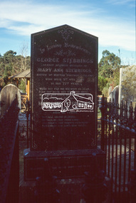 Eltham District Historical Society Inc
Slide - Photograph, Nillumbik Cemetery, 35 Main Street, Diamond Creek, 27 May 1990
... Nillumbik Cemetery, 35 Main Street, Diamond Creek... was interred at Diamond Creek on Sunday, 7th inst. Local Cemetery... was interred at Diamond Creek on Sunday, 7th inst. Local Cemetery ...George Stebbing arrived from England in 1857 and settled at Eltham after a short period at Kangaroo Ground. His occupation is often listed as a farmer but he built a number of important buildings between the late 1860’s and the 1880’s. Those remaining include Shillinglaw Cottage, St. Margaret’s Church, Uniting church (formerly Methodist Church) and House at 84 Pitt Street, Eltham. From 1871 to 1875 he was a member of the Eltham Shire Council. Evelyn Observer and Bourke East Record (Vic. : 1902 - 1917), Friday 12 March 1909, page 2 ELTHAM. (FROM OUR OWN CORRESPONDENT.) One of the oldest inhabitants of Eltham passed away during the early hours of Saturday last in the person of Mrs Mary Ann Stebbings. Her residence here covered a period of some-what over 50 years. She had been a widow for some time, her husband, the late Mr. Geo. Stebbings, having pre-deceased her some fourteen or fifteen years. During the later years of her life, she had resided with her niece, Mrs. Wm. Williams. She lived a very retired life and is said to have owned a considerable amount of property, local and suburban, at the time of her death, at the age of 82 years. She was interred at Diamond Creek on Sunday, 7th inst. Local Cemetery Excursion Sunday 27 May 1990 departed Eltham Shire Office at 9.30am and finish mid afternoon. Visits to Eltham , Kangaroo Ground, Queenstown (Smiths Gully), Nillumbik (Diamond Creek), St Katherines (St Helena) Hurst family graves at Hurstbridge and a little known early cemetery at Greensborough. Attended by 20 members. In each case we were introduced to the cemetery with a brief talk. At Eltham, Frank Burgoyne gave us the benefit of his knowledge as a member of the cemetery trust and at Kangaroo Ground, Bruce Ness spoke in a similar capacity. The lunch stop was at Hurstbridge where we visited the Hurst family graves. The President of Nillumbik Historical Society, Jock Ryan, joined us at the Nillumbik (Diamond Creek) cemetery. He travelled on to St Katherines, St Helena, where he talked on the history of the church and cemetery. 35mm colour positive transparency (1 of 23) Mount - Agfachrome Agfa CS System black 8 dotsshire of eltham historical society, cemetery excursion, graves, activities, cemeteries, george stebbing, george stebbings, mary ann stebbing, mary ann stebbings, nillumbik cemetery -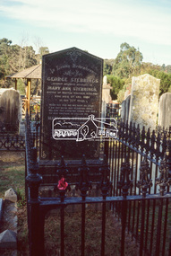
 Eltham District Historical Society Inc
Document - Folder, Miscellaneous newsclippings pertaining to Eltham Public Hall (henry Street and Arthur Street), 1903-1951
... Shires Advertiser and Diamond Creek Valley Advocate (Vic. : 1917... Shires Advertiser and Diamond Creek Valley Advocate (Vic. : 1917 ...CONCERT AT ELTHAM. (1902, June 20). Mercury and Weekly Courier (Vic. : 1878 - 1903), p. 3. Retrieved November 22, 2024, from http://nla.gov.au/nla.news-article58580761 NEW PUBLIC HALL AT ELTHAM. (1921, December 2). Eltham and Whittlesea Shires Advertiser and Diamond Creek Valley Advocate (Vic. : 1917 - 1922), p. 3 (MORNING.). Retrieved November 22, 2024, from http://nla.gov.au/nla.news-article57640472 ELTHAM HALL (1924, February 22). Advertiser (Hurstbridge, Vic. : 1922 - 1939), p. 3 (AFTERNOON). Retrieved November 22, 2024, from http://nla.gov.au/nla.news-article56656807 THE Eltham and Whittlesea Shires Advertiser AND Diamond Creek Valley Advocate (1925, February 6). Advertiser (Hurstbridge, Vic. : 1922 - 1939), p. 2 (AFTERNOON). Retrieved November 22, 2024, from http://nla.gov.au/nla.news-article56658074 ELTHAM PUBLIC HALL. (1927, January 21). Advertiser (Hurstbridge, Vic. : 1922 - 1939), p. 3 (AFTERNOON.). Retrieved November 22, 2024, from http://nla.gov.au/nla.news-article57754280 ELTHAM. (1927, January 28). Advertiser (Hurstbridge, Vic. : 1922 - 1939), p. 3 (AFTERNOON.). Retrieved November 22, 2024, from http://nla.gov.au/nla.news-article57754308 ELTHAM. (1929, February 15). Advertiser (Hurstbridge, Vic. : 1922 - 1939), p. 2 (AFTERNOON.). Retrieved November 22, 2024, from http://nla.gov.au/nla.news-article57759218 ELTHAM PUBLIC HALL. (1929, March 1). Advertiser (Hurstbridge, Vic. : 1922 - 1939), p. 3 (AFTERNOON.). Retrieved November 22, 2024, from http://nla.gov.au/nla.news-article57759343 Eltham Council; Items of Interest (1951, September), Heidelberger, p1 – Eltham Public Hall Committee granted Council approval to purchase two shop frontage blocks next to shire hall. Traces the earliest history of the Eltham Public Hall in Henry Streeteltham public hall, eltham shire hall, henry street, eltham rechabite hall, arthur street -
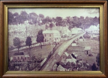 Greensborough Historical Society
Photograph - Photograph (Framed), St Helena and Diamond Creek Roads Greensborough 1889, 1889
... St Helena and Diamond Creek Roads Greensborough 1889... the corner of St Helena Road and Diamond Creek Roads. This copy has... the corner of St Helena Road and Diamond Creek Roads. This copy has ...A view of Greensborough township 1889, painted from the corner of St Helena Road and Diamond Creek Roads. This copy has been cropped from the original to show lower Main Street and Marble hall. The original of this painting is owned by Greensborough Primary School.From the John Mackey collection. this item was displayed at the offices of Ryan, Mackey and Kelly, solicitors, Main Street Greensborough.Small timber-framed photograph of road and houses, sepia.greensborough, main street greensborough, marble hall greensborough, arthur elliott, john mackey