Showing 3425 items
matching distance
-
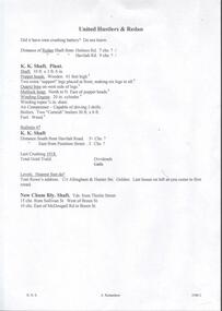
![Map, Ballarat and Gordons Lane Plan of Land required [for railway line work]](/media/collectors/5e461d8021ea67224c82f2a1/items/676ff3a62c3783fe00b96a8d/item-media/676ff4a42c3783fe00b96cb6/item-fit-380x285.jpg) Bacchus Marsh & District Historical Society
Bacchus Marsh & District Historical SocietyMap, Ballarat and Gordons Lane Plan of Land required [for railway line work]
The railway line from Melbourne to Bacchus Marsh was completed in February 1887. After this date work continued to extend the line to Ballan. This map indicates a portion of land only a few hundred metres west of the Bacchus Marsh railway station which would have been among the first stages of the line to Ballan to have been constructed. This suggests the date of this map to be in the late 1880s.Single page map showing land required for railway line work near Griffith Street, Bacchus Marsh. Scale 10 chains to 1 inch. Hand-written on the map are the exact distances between Bacchus Marsh and Gordons (Gordon) and between Bacchus Marsh and Melbourne as measured from the corner of Maddingley Road and Station Street. Distances recorded are in miles, chains and links. The land required for the railway works is marked in red ink and runs through an area known as Kennedy's Gully. Part of a set of maps which are pasted into a bound volume containing 76 maps or plans in total. High resolution digital image stored on BMDHS computer network. bacchus marsh victoria history, maddingley victoria history, railway lines -
 Flagstaff Hill Maritime Museum and Village
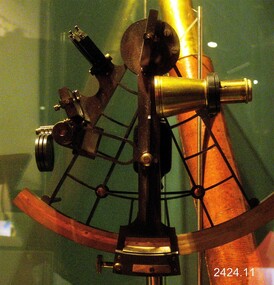
Instrument - Sextant, Late 20th Century
In 1941, the scientific instrument manufacturing firms of Henry Hughes & Son Ltd, London, England, and Kelvin Bottomley & Baird Ltd, Glasgow, Scotland, came together to form Kelvin & Hughes Ltd. Kelvin Company History: The origins of the company lie in the highly successful and strictly informal relationship between William Thomson (1824-1907), Professor of Natural Philosophy at Glasgow University from 1846-1899 and James White, a Glasgow optical maker. James White (1824-1884) founded the firm of James White, an optical instrument maker in Glasgow in 1850 and was involved in supplying and mending apparatus for Thomson university laboratory and working with him on experimental constructions. White was declared bankrupt in August 1861 and released several months later. In 1870, White was largely responsible for equipping William Thomson laboratory in the new University premises at Gilmore hill. From 1876, he was producing accurate compasses for metal ships to Thomson design during this period and this became an important part of his business in the last years of his life. He was also involved in the production of sophisticated-sounding machinery that Thomson had designed to address problems encountered laying cables at sea, helping to make possible the first transatlantic cable connection. At the same time, he continued to make a whole range of more conventional instruments such as telescopes, microscopes and surveying equipment. White's association with Thomson continued until he died. After his death, his business continued under the same name, being administered by Matthew Edwards (until 1891 when he left to set up his own company. Thomson who became Sir William Thomson and then Baron Kelvin of Largs in 1892, continued to maintain his interest in the business after James White's death. In 1884 raising most of the capital needed to construct and equip new workshops in Cambridge Street, Glasgow. At these premises, the company continued to make the compass Thomson had designed during the 1870s and to supply it in some quantity, especially to the Admiralty. At the same time, the firm became increasingly involved in the design, production and sale of electrical apparatus. In 1899, Lord Kelvin resigned from his University chair and became, in 1900, a director in the newly formed limited liability company Kelvin & James White Ltd which had acquired the business of James White. At the same time Kelvin's nephew, James Thomson Bottomley (1845-1926), joined the firm. In 1904, a London branch office was opened which by 1915 had become known as Kelvin, White & Hutton Ltd. Kelvin & James White Ltd underwent a further change of name in 1913, becoming Kelvin Bottomley & Baird Ltd. Hughes Company History: Henry Hughes & Sons were founded in 1838 in London as a maker of chronographic and scientific instruments. The firm was incorporated as “Henry Hughes & Sons Ltd” in 1903. In 1923, the company produced its first recording echo sounder and in 1935 a controlling interest in the company was acquired by S Smith & Son Ltd resulting in the development and production of marine and aircraft instruments. Following the London office's destruction in the Blitz of 1941, a collaboration was entered into with Kelvin, Bottomley & Baird Ltd resulting in the establishing “Marine Instruments Ltd”. Following the formal amalgamation of Kelvin, Bottomley & Baird Ltd and Henry Hughes & Sons Ltd in 1947 to form Kelvin & Hughes Ltd. Marine Instruments Ltd then acted as regional agents in the UK for Kelvin & Hughes Ltd who were essentially now a part of Smith's Industries Ltd founded in 1944 and the successors of S. Smith & Son Ltd. Kelvin & Hughes Ltd went on to develop various marine radar and echo sounders supplying the Ministry of Transport, and later the Ministry of Defence. The firm was liquidated in 1966 but the name was continued as Kelvin Hughes, a division of the Smiths Group. In 2002, Kelvin Hughes continues to produce and develop marine instruments for commercial and military. G. Falconer Company History: G Falconer (Hong Kong Ltd) appear to have had a retail presence in Hong Kong since 1885, according to the company website, and currently have a shop in the Peninsula Hotel. G Falconer was the Hong Kong selling agent for several British companies. Ross Ltd of 111 New Bond St London was one and the other was Kelvins Nautical Instruments. Falconers were primarily watchmakers, jewellers and diamond merchants.They were also agents for Admiralty Charts, Ross binoculars and telescopes, and sold English Silverware and High Class English Jewellery. In 1928 the company was operating from the Union Building opposite the Hong Kong general post office. It is unclear if the item is an original Sextant made by Kelvin prior to his amalgamation with Henry Hughes & Sons in 1941 as Kelvin appears to have only made compasses up to this date. If the Sextant can be established that it was made by Kelvin then it is very significant and a rare item made for and distributed through their Hong Kong selling agents G Falconer Ltd. There are many Sextants advertised for sale stating "Kelvin & Hughes 1917 model sextant". These can be regarded as replicas as the company was not formed until 1941 and production of marine instruments was not fully under way until after the war in 1947. Further investigation needs to be undertaken to accurately determine the provenance of this item. As the writer currently has the impression that the subject object was possibly made by Kelvin and Hughes in the mid to late 20th century or is a replica made by an unknown maker in the late 1970s. Purchased as an exhibition of marine navigational instruments for the Flagstaff Hill museum. The Sextant is a brass apparatus with filters and telescope lens, and comes with a wooden felt lined storage box. It is a doubly reflecting navigation instrument that measures the angular distance between two visible objects. The primary use of a sextant is to measure the angle between an astronomical object and the horizon for the purposes of celestial navigation.G Falconer and Co. Hong Kong (retailers of nautical equipmentflagstaff hill, warrnambool, shipwrecked-coast, flagstaff-hill, flagstaff-hill-maritime-museum, maritime-museum, shipwreck-coast, flagstaff-hill-maritime-village, sextant, kelvin & hughes ltd, hong kong, navigational instrument, g falconer, mariner's quadrants -
 Warrnambool and District Historical Society Inc.
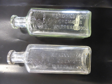
Bottle, R F Kennedy & Co x2, Early 20th century
These bottles were used in the Warrnambool pharmacy of R. F. Kennedy & Co. Richard Frank Kennedy (1826-1903) was born in England and came to Warrnambool in the early 1880s, establishing a pharmacy in Timor Street. This was a retail, wholesale and manufacturing business. In 1891 Kennedy erected a new building which was described as one of the most elegant and best-stocked chemist’s shops in Victoria. Kennedy was active in Warrnambool community affairs and was a foundation member of the Warrnambool Bowls Club, being its first Vice-President and an early President. His business continued on after his death, trading as ‘R.F.Kennedy and Co.’ Richard Frank Kennedy was one of the most significant businessmen in Warrnambool in the late 19th century. The products of his shop and factory were distributed all over Victoria and beyond. These bottles are good examples of the types used in the Kennedy pharmacy. They show the well-known Kennedy lighthouse symbol. Warrnambool still has two working lighthouses today. These are two clear glass chemist’s bottles. They are identical in size and shape. They have a rectangular-shaped body with rounded edges, a circular-shaped neck and a moulded top with an opening. There are no stoppers. The sides of the bottles have the Kennedy logo of a lighthouse on a rocky cliff on the coastline with ships in the distance and the name of the chemist (R.F.Kennedy). ‘2/3 viii’ ‘R.F.Kennedy & Co. Chemists Warrnambool’ ‘L 389 M’ ‘A.G.M.’ r.f.kennedy,, warrnambool chemist, chemists in warrnambool, history of warrnambool -
 Glenelg Shire Council Cultural Collection
Photograph - Photograph - Bentinck street, Portland, n.d
Black and white photo. View of Bentinck St., looking north. Taken from footpath outside Free Library Hall, lamppost, man standing on footpath. Mac's Hotel visible on left, building in the block between Gawler and Julia Sts., spire of All Saints can be seen in distance.Back: 'Bentinck Street Portland' - handwritten in black inkportland cbd, bentinck street, macs hotel -
 Flagstaff Hill Maritime Museum and Village
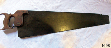
Saw
Handsaw with taper ground blade. Handle entirely enclosed and slotted to take heel of blade which is set in place with three brass rivets. Handle elaborately carved with fishtail and decorative curve. Short distance from toe is a small notch or nib. Has Buck London stamped on bladeflagstaff hill, warrnambool, shipwrecked-coast, flagstaff-hill, flagstaff-hill-maritime-museum, maritime-museum, shipwreck-coast, flagstaff-hill-maritime-village, handsaw -
 Bendigo Historical Society Inc.
Photograph - LITTLE 180 MINE, 1920
black and white photo: street scene, blue stone gutter, wooden electricity pole, adult female standing on road, middle distance. In background, poppet legs, tall chimney, building At left. Striped pole in centre. On back of photo ' Main street Bendigo, leading to mine/1920 'cottage, miners -
Bendigo Historical Society Inc.
Document - MINING REPORTS - MINING REPORTS - ST MUNGO, SHENANDOAH
Handwritten extracts mentioning the St. Mungo Battery, the Shenandoah, and the St. Mungo, E'hawk. Notes mention engine, boilers and engine & boiler housing. Also mentioned are gold yields, Dividends, Calls, battery and distance along the reef for the Shenandoah Mine and contractor erecting machinery at the St. Mungo Mine.document, gold, mining reports, mining reports, mining reports st mungo shenandoah, sec mines & water supply annual report, mining machinery report p 58 & 59, st. mungo battery, shenandoah, a m s 1/6/1899 page 37, st mungo mine, 'the federal australian' extracts from mining notes s'hurst -
 Bendigo Historical Society Inc.
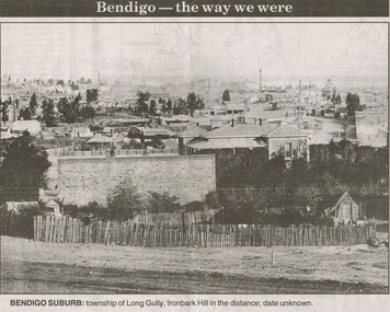
Newspaper - LONG GULLY HISTORY GROUP COLLECTION: BENDIGO - THE WAY WE WERE - LONG GULLY
Black and white photo from Bendigo - the way we were series in the Bendigo Advertiser, November 14, 2000. The photo shows the township of Long Gully, Ironbark Hill in the distance. Date unknown. The photo shows houses, mine chimneys, trees and a rough picket type fence in the foreground.bendigo, history, long gully history group, the long gully history group - bendigo - the way we were - long gully, bendigo advertiser 14/11/2000, ironbark hill -
 Stawell Historical Society Inc
Photograph, Cato Lake -- Willow Walk
Valentine Series No 1083 The Willows Victoria Park. This photo was possibly taken before the diving tower and change rooms were erected. The Victoria Park name was changed to Cato Park in 1930.Two original Valentine Series and one enlarged black and white photograph of Victoria Park later called Cato Park. The two Valentine Series No 1083 show the willows to the left and buildings hidden by trees in the distance surrounding the lake. The lake is very still and reflective of the trees around the lake.Valentine Series No 1083 The Willows, Victoria Park, Stawell on the back Valentines real phot series Valentine Publishing Co Melbourne & Sydney. written in pencil "Pre 1930 Duplicate of 67.9"stawell -
 Kew Historical Society Inc
Photograph - Looking towards Kew from Strathalbyn Street and High Street, c.1916
An electrified tram route from Melbourne along High Street replaced an original Horse Tram that terminated at the Kew Cemetery. This new tram only reached the bridge over the Outer Circle railway at the Harp Junction. The line was later extended to North Balwyn.Black and white print positive showing the view west along High Street, Kew (formerly Bulleen Road). In the centre distance is the Boroondara General (Kew) Cemetery. In the foreground, the road crosses the Outer Circle railway. The photograph reflects the level of urbanisation in Kew during the First World War. "Looking towards Kew from Strathalbyn St / High St corner, about 1916. Courtesy Mrs E Bennett, Kew East / Property of Miss Foley"trams -- kew, trams -- kew east, mmtb, m&mtb, tramways, harp junction -
 Lakes Entrance Historical Society
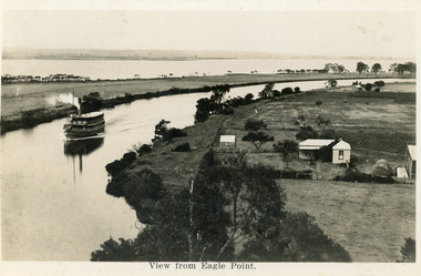
Postcard - Eagle Point, 1930 c
Black and white postcard S S Gippsland in Mitchell River, travelling towards Bairnsdale, silt jetties extending eastwards small farm, farm house and sheds on right. Jones bay in Middle distance beyond silt jetty, taken from Eagle Point Bluff. Bairnsdale VictoriaView from Eagle Point. ships and shipping, waterways, agriculture, houses -
 Lakes Entrance Historical Society
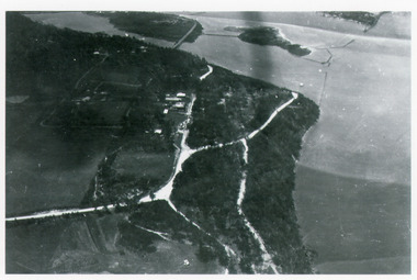
Photograph - Kalimna, Bulmer H D, 1940c
Black and white photograph of aerial view of Kalimna escarpment, Princes Highway, road to Kalimna Hotel, scattering of buildings including Gainsborough House, in distance is North Arm bridge, footbridge to undeveloped Bullock Island with rock groynes in place. Part of eastern pier of entrance at Lakes Entrance, Victoria. waterways, topography, township, bridges -
 Bendigo Historical Society Inc.
Document - UNITED HUSTLERS AND REDAN - NOTES ON THE UNITED HUSTLERS AND REDAN
Part of a page of notes on the United Hustlers and Redan. Notes include K. K. Shaft Plant, Size of Shaft,Poppet Heads, Quartz bins, Mullock Heap, Winding Engine Air Compressor and Boilers. On the back some questions are written, distances of shafts from streets and last crushing.document, united hustlers and redan, notes on the united hustlers and redan, k k shaft, tom rowe, new chum railway -
 Glenelg Shire Council Cultural Collection
Equipment - Surveyors chain, unknown
Before metric measurement was introduced land was measured by a tool of chains and links called a surveyor's chain. The first surveyor's chain was designed by the English clergyman and mathematician Edmund Gunter (1581-1626) and introduced in 1620. It comprised of a metal chain made up of 100 links measuring a precise overall length of 66 ft or 22 yards, with each link measuring 7.92 inches (201.168 mm). The Gunter's chain was originally intended to be used in the accurate laying out and measurement of plots of land, for legal and commercial purposes, but was subsequently widely used by surveyors throughout the British Empire and Europe, with an Imperial mile being 80 times the Gunter's chain length. A tool used to survey the land before the introduction of the metric system.Surveyor chain Gunter type, 100 links measuring 66 feet in length. Hand grips at each end of chain. Wire links are approximately eight inches long. Incised tags or markers are attached to each tenth link of chain to assist with the more accurate recording of intermediate distances.surveying tool -
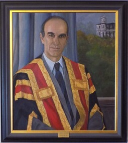 Geoffrey Kaye Museum of Anaesthetic History
Painting - Portrait, Audrey Wilson, Presidential Portrait of Dr Michael J H Hodgson, 1995
Dr Michael Hodgson was apppointed ANZCA President in 1992 until 1993. The painting, undertaken in 1995, was later unveiled in 1996 with Dr. Hodgson present. Further information about Dr. Hodgson can be found on The Lives of the Fellows, http://anzca.online-exhibition.net/fellows/fellows-1992/michael-john-hind-hodgson/ Oil painting on canvas of Dr Michael J H Hodgson seated in front of blue-grey drapery and a window showing Ulimaroa in the distance. The subject is wearing the Presidential gown but not the Presidential badge. Framed in a plain grey and gold frame with a brass plaque affixed on bottom center front of frame. [plaque] Dr Michael J H Hodgson / President 1992 - 1993 [Artist's signature lower right corner] Audrey Wilson / 1995hodgson, michael, anzca president, ulimaroa -
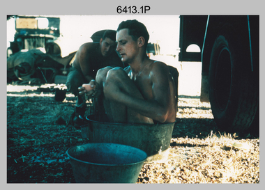 Bendigo Military Museum
Photograph - Royal Australian Survey Corps Surveyors in the Field – North Queensland, 1958
This is a set of seven photographs of surveyors and support staff in the field undertaking duties in North Queensland in 1958. The surveyors were employed in the establishment of mapping and geodetic control. In this era surveyors used theodolites to observe horizontal and vertical angles and chains to measure base line distances between survey stations. Bob Skitch shown in photos .4P to .6P was in the 2nd year of his career in the Australian Army. He achieved the rank of Lieutenant Colonel and his last appointment was the CO of the Army Survey Regiment from 1976 to 1980. The annotation on the back of photo .5P ‘Black foreground is where Bob Skitch boiled billy and started a grass fire’.This is a set of seven photographs of surveyors and support staff in the field undertaking duties in North Queensland in 1958. The photographs were printed on photographic paper and are part of the Army Survey Regiment’s Collection. The photographs were scanned at 300 dpi. .1) - Photo, colour, 1958. Surveyor in Nth QLD enjoying a bath. L to R: Don Cocker, Bob Thompson. .2) - Photo, colour, 1958. Don Cocker surveyor in Nth QLD, enjoying a bath. .3) - Photo, colour, 1958. Surveyors Nth QLD undertaking survey observations, using MRA1 tellurometer to measure base-line distances. L to R: Len Davies, Lou Sommer, John Van De Graff. MRA1 was covered to stop overheating. .4) - Photo, colour, 1958. Surveyors south of Richmond, QLD digging holes for the erection of a Bilby observation tower. L to R: John Van De Graff, Bob Skitch, Kev Moody, Mal Hayes, Don Gray .5) - Photo, colour, 1958. Surveyors south of Richmond, QLD erecting a Bilby observation tower. L to R: Tom Royle, Bob Skitch (on ground level), Mal Hayes. .6) - Photo, colour, 1958. Surveyors south of Richmond, QLD erecting a Bilby observation tower. L to R: Tom Royle, Bob Skitch, Mal Hayes, Jim McGill (on ground level). .7) - Photo, colour, 1958. Surveyors south of Richmond, QLD undertaking survey measurements from a Bilby observation tower..1P to .7P annotated on back – personnel names, the year and the location. Annotated on back of .5P ‘Black foreground is where Bob Skitch boiled billy and started a grass fire’.royal australian survey corps, rasvy, army survey regiment, asr, army svy regt, fortuna, surveying -
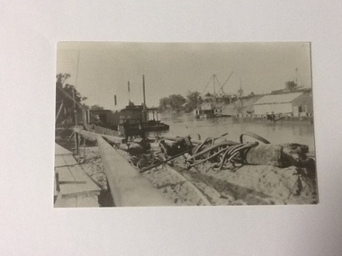 Port of Echuca
Black and white photograph, Approx 1980
Scene depicted is believed to have been the Euston Lock. It shows various pieces of equipment in the foreground , with a pontoon names Bream on the left bank with a paddle steamer, sheds and cranes in the distance on the right hand side of the photograph. Original photograph from the Price collection. Historically and socially significant photograph depicting early 1920's life on the Murray river.Black and white photograph of river scene depicting , by the left bank a pontoon "Bream" and by the right bank a steamboat behind a shelter construction. There are various cranes on the right bank. Copy of an original photograph taken in the 1920s believed to at Euston Lock, N.S.W.In pencil on back: Price / believed to be Euston Lock.riverboats, paddle steamers, price collection -
 Eltham District Historical Society Inc
Slide, Construction of Eltham Town Park, 22 Feb 1974
Construction of Eltham Town Park, later renamed Alistair Knox Park. In the distance can be seen the Eltham Tip accessed from Susan Street and the Shell Service Station which was situated on the corner of Susan Street and Bridge Street, now the site of Bunnings35 mm colour positive transparency Mount - Agfacolor Service (Blue)alistair knox park, eltham town park, eltham tip, shell service station, susan street -
 Eltham District Historical Society Inc
Photograph, Looking east from the northern side of Lower Plenty Road (opposite Bannockburn Road) as it crosses the Watsonia Drain, Viewbank, c.1965, 1965c
Transmission power lines visible in distance behind the Lower Plenty Hotel (in centre upper) and parts of Heidelberg Golf Club. In the foreground a bulldozer can be seen commencing roadworks for the re-alignment of Lower Plenty Road for the new Lower Plenty Bridge crossing.Medium format 120 6x6 black and white negative film, 1 frameheidelberg golf club, lower plenty, lower plenty hotel, road construction, viewbank, watsonia drain -
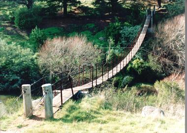 Hume City Civic Collection
Photograph, 1980s
The timber and cable swing bridge straddled the Deep Creek at Bulla behind the Bulla school. It enabled children who lived across the river to travel directly to school instead of going the long way around the road, a possible distance of 2-3 kms.A coloured photograph of the timber and cable swing bridge which was constructed across the Deep Creek at Bulla. Trees are growing along the river bank and there is a row of conifers growing along the opposite bank.swing bridges, deep creek, george evans collection -
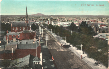 Ballarat Tramway Museum
Postcard, "Sturt St Ballarat" - from fire station, c1910
Photograph - looking east along Sturt Street from the Ballarat City Fire station tower. Shows a ESCo tram east bound. Mount Warrenheip can be seen in the far distance along with St Patrick's Cathedral and the St Andrews Scots church.Yields information about the streetscape of Sturt St.Postcard coloured, divided back, unused, Valentine & Sons.tramways, trams, esco, sturt st -
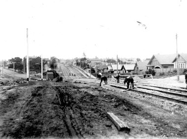 Ballarat Tramway Museum
Photograph - Geelong Tramway North line
Men laying sleeper tram tracks for the North tram route along The Esplanade. In the midddle distance, the double track towards the city is in Mercer St. (now The Esplanade South). The street off to the left is Victoria Tce., (now Western Beach Road). 1928Black and white print on paper.GRS710/25/1/10 and 25-10, written on the reverse in paper. The No., 2 inside a circle, written on the reverse in ink.geelong tramway, geelong tramway laying sleeper tracks -
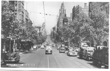 Melbourne Tram Museum
Postcard, Valentine's, "Collins Street Melbourne", late 1930s
Valentine's postcard titled "Collins Street Melbourne", Number V39, looking west from Russell Street with some trams in the far distance. On the right hand side are two trucks carrying large barrels. In the view is the Town Hall and the Manchester Unity building.Yields information about Collins Street during the late 1930s.Postcard - printed, unused, Valentine Seriestrams, tramways, collins st -
 Ringwood and District Historical Society
Photograph, Cnr Maroondah Hwy and Ringwood Street, Ringwood. (undated)
Written on back of photograph, "Left hand side of picture: Post Office on corner of Maroondah Highway and Ringwood Street. Right hand side Ibbotson & Sons Highway and corner store, corner Maroondah Highway and Wantirna Road. In distance old cool stores." -
 Federation University Historical Collection
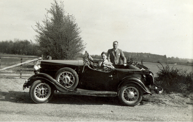
Photograph, Frank Wright, 1953, 26/4/1953
Frank Wright was a renown resident of Smeaton, where he was born. He lived at Laura Villa, and attended Smeaton State School. His father William was a gold miner and his mother's name was Sarah. Their family won many singing and instrumental awards. Frank was tutored by Percy Code and was awarded a gold medal for the highest marks in the ALCM examinations in the British Colonies at the age of seventeen years. He became the Australian Open Cornet Champion by the age of eighteen. A year later, Frank conducted the City of Ballarat Band, and later the Ballarat Soldiers’ Memorial Band. He formed the Frank Wright Frisco Band and Frank Wright and his Coliseum Orchestra. These bands won many South Street awards, and Frank as conductor won many awards in the Australian Band Championship contest. In 1933 Frank Wright sailed to England to conduct the famous St Hilda’s Band and was later appointed Musical Director of the London County Council, where he organized many amazing concerts in parks, in and around the London district. He was made Professor of Brass and Military Band Scoring and conducted at the Guildhall of Music and Drama. Frank was often invited to adjudicate Brass Band Championships around Europe, in Australia, including South Street and in New Zealand. The Frank Wright Medal at the Royal South Street competition is awarded to an individual recognized as making an outstanding contribution to brass music in Australia.Black and white photograph of two men dressed in suits, one standing behind an open tourer car and the other is sitting at the driver's steering wheel. They are parked beside a gravel road with a gate and fence directly behind and then open fields and in the far distance is a row of trees. The man standing is Frank Wright.Written in pencil on back - 26/4/53frank wright, open tourer, conductor, car, automobile, transport -
 Bendigo Historical Society Inc.
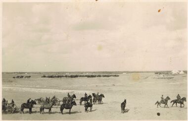
Postcard - ACC LOCK COLLECTION: B&W PHOTO OF TEAMS OF HORSE DRAWN ARTILLERY, POSTCARD, 1914-1918
Postcard, WW1, B&W photo of horse drawn artillery on a treeless plain. In the foreground - two canons each drawn by 3 mounted horses, one riderless horse and two officers riding off to the right. In the distance is a row of horse drawn artillery and some tents at the right. Location not known.postcard, postcard, ww1, horse drawn artillery, france -
 Bendigo Historical Society Inc.
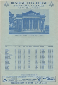
Document - MASONIC CALENDAR
Bendigo City Lodge 1987 Masonic Calendar for Central Victoria. Printed in blue on light blue card showing an illustration of the Masonic Hall Sandhurst circa 1885. The calendar list the lodge location, number, when the meet, the time of meeting the distance from Bendigo, installation, secretary and private phone.organization, club/society, freemasonry - lodge -
 Bendigo Historical Society Inc.
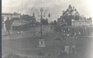
Photograph - HARRY BIGGS COLLECTION: HIGH ST. EAGLEHAWK
Photograph. Harry Biggs Collection. 1 photo and a copy of High St. Eaglehawk. The tram lines can be clearly seen as are the arc lamps typical of the times. Some people can be seen and a horse and cart in the distance. A dog is on the tram tracks. A Havelock sign can be seen above the shop to the right.photograph, streetscape, eaglehawk, harry biggs collection, high st. eaglehawk -
 Bendigo Historical Society Inc.
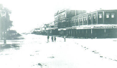
Photograph - PALL MALL, 1876
Black and White Photo of Pall Mall, Building at the Corner of Pall Mall and Mitchell Streets has the Sign 'John Paterson' and 'John Paterson Tailor', 4 small children are at the centre of the photo, Beehive Building, Shamrock Building in the distance, Markings on rear of the photo are 'Pall Mall', 'Holterman Collection 1876'buildings, commercial, pall mall, john paterson, beehive, shamrock -
 Bendigo Historical Society Inc.
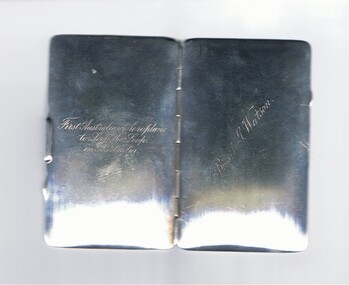
Memorabilia - BASIL WATSON COLLECTION: STERLING SILVER CARD CASE, 1917
Sterling silver card case (B Watson) - hinged with single brass leaf insider engraved with details of Watson's flights and achievements in Australia - destinations,distance, time, date inscribed on inside of case.. On front ''Basil G. Watson''; on back ''First Australian to Loop the Loop in Australia'' (engraved inscriptions)person, individual, basil watson