Showing 1568 items
matching documents - maps
-
 Whitehorse Historical Society Inc.
Document, List of schools in the city of Nunawading, 1969
List of schools in the City of Nunawading and hand drawn map showing locations.city of nunawading, schools -
Whitehorse Historical Society Inc.
Document, Melbourne's Valley of the Arts, 2002
Map, brochure and copy of 'Melbourne's Valley of the Arts Tourism Newsletter Jan 2002Map, brochure and copy of 'Melbourne's Valley of the Arts Tourism Newsletter Jan 2002Map, brochure and copy of 'Melbourne's Valley of the Arts Tourism Newsletter Jan 2002tourist attractions, map -
Whitehorse Historical Society Inc.
Document, F. S. Baker/ Yarra Hill country map, 1950s
... Country F. S. Baker/ Yarra Hill country map Document Document ...Advertising leaflet for F. S. Baker, Mt. Pleasant Road Nunawading,Advertising leaflet for F. S. Baker, Mt. Pleasant Road Nunawading, Real Estate Agent c. 1950s, backed by Broadbent's Map no. 280, Yarra Hill CountryAdvertising leaflet for F. S. Baker, Mt. Pleasant Road Nunawading, broadbents, baker, f. s., mount pleasant road, nunawading, no. 20 -
Whitehorse Historical Society Inc.
Document, Blackburn Township Estate, 1906
110 business and residential sites for sale.110 business and residential sites for sale, Saturday 6th October 1906. Stamped by T.R.B. Morton, Financial and Estate Agent, 80 Swanston St. Melbourne.110 business and residential sites for sale.blackburn township estate, morton, thomas richards burrowes, haughton maps -
 Whitehorse Historical Society Inc.
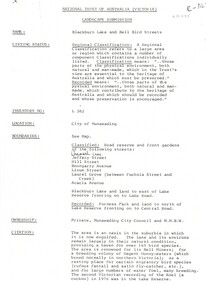
Document, Landscape Submission, c 1976
... . Photographs and map. Landscape Submission Document Document ...A landscape submission written for the National Trust of Australia (Victoria) for Blackburn Lake and the Bell Bird Streets.A landscape submission written for the National Trust of Australia (Victoria) for Blackburn Lake and the Bell Bird Streets. Definitions given of boundaries of the Lake area, ownership, housing and gardens. Photographs and map.A landscape submission written for the National Trust of Australia (Victoria) for Blackburn Lake and the Bell Bird Streets.blackburn lake sanctuary, waratah crescent, blackburn, jeffery street, hill street, boongarry avenue, linum street, laurel grove, acacia avenue, city of nunawading, melbourne and metropolitan board of works, furness park, camberwell grammar school -
Whitehorse Historical Society Inc.
Document, Mitcham before 1940s, 1970s?
Four pages of sketch maps of Mitcham business areas.Four pages of sketch maps of Mitcham business areas. Includes: brief history of three hotels; Timeline of development 1851-1971; Details from 1924 Census re local traffic; Details from 1854 Census re populationnon-fictionFour pages of sketch maps of Mitcham business areas. hill hotel, mitcham, mitcham hotel, australia. census 1854, census 1924, traffic, mitcham road mitcham, station street mitcham, britannia street mitcham, whitehorse road mitcham, harvest home hotel -
Whitehorse Historical Society Inc.
Document, Fromelles, 2012
Transcription of talk on the Battle of Fromelles.Transcription of talk on the Battle of Fromelles by Lambos Englezos to Whitehorse Historical Society 14 April 2012. With map of battle area. Tape at NP 3908Transcription of talk on the Battle of Fromelles.world war 1914-1918, fromelles -
 Whitehorse Historical Society Inc.
Document - Correspondence, Anderson's Station, 2/10/1842
Photocopy of a letter from James Anderson dated 2 October 1842 complaining of incursions by stock of Major Newman on Anderson's adjoining land. Includes sketch map of relative locations of neighbouring runs bordered by the Yarra River.anderson, james, newman, (major), dawsons station, ross station, yarra river, agriculture, pioneers, deep creek, nunawading -
 Whitehorse Historical Society Inc.
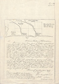
Document, Yarran Dheran, ?1985
Information brochure on development and features of Yarran Dheran Reserve, including map. Prepared by City of Nunawading Parks and Recreation Department, ?1985.yarran dheran, parks and reserves -
Whitehorse Historical Society Inc.
Document, Heritage Precincts Report 2004, 2004
Heritage Precincts report 2004, City of Whitehorse, with photos and maps of the precincts.Heritage Precincts report 2004, City of Whitehorse, with photos and maps of the precincts.Heritage Precincts report 2004, City of Whitehorse, with photos and maps of the precincts.mount view court precinct, burwood, blacks estate precinct, mont albert, thomas street precinct, mitcham, windsor park estate precinct, surrey hills -
Whitehorse Historical Society Inc.
Document, Villa Residence, 11/12/1937 12:00:00 AM
... in conjunction with Drake & Co. Original copy framed, located in Map ...Auction brochure for 'beautiful modern brick villa residence', with 4 1/4 acres of land, Mitcham Road Mitcham, Saturday December 11 1937.Auction brochure for 'beautiful modern brick villa residence', with 4 1/4 acres of land, Mitcham Road Mitcham, Saturday December 11 1937, under instructions from the executors of the estate of the late E. E. Walker. Frontages to Mitcham Road, Delhi Street and Agra Street. Auctioneers: Baillieu Allard in conjunction with Drake & Co. Original copy framed, located in Map Drawer.Auction brochure for 'beautiful modern brick villa residence', with 4 1/4 acres of land, Mitcham Road Mitcham, Saturday December 11 1937.walker, edgar edwardes, walker estate, mitcham road, mitcham, delhi street mitcham, agra street, mitcham, drake & co., baillieu allard pty ltd -
Whitehorse Historical Society Inc.
Document, Walker Estate Mitcham, 8/10/1938 12:00:00 AM
Auction brochure for 'Beautiful brick residence' of 9 rooms, with 1 1/2 acres of grounds, subdivided into 12 sites for brick residences, Saturday 8th October 1938.Auction brochure for 'Beautiful brick residence' of 9 rooms, with 1 1/2 acres of grounds, subdivided into 12 sites for brick residences, Saturday 8th October 1938, by order of the Executors of the late E. E. Walker. Frontages to Mitcham Road, Agra Street, Simla Street and Meerut Street. Auctioneers: Edward Haughton Pty Ltd and Drake & Co. Original copy framed, located in Map Drawer.Auction brochure for 'Beautiful brick residence' of 9 rooms, with 1 1/2 acres of grounds, subdivided into 12 sites for brick residences, Saturday 8th October 1938.walker, edgar edwardes, walker estate, mitcham road, mitcham, agra street mitcham, simla street mitcham, meerut street mitcham, drake & co., edward haughton pty ltd -
Whitehorse Historical Society Inc.
Document, 'Through her eyes', 2007
The Women's map of Melbourne City. Key dates, map, significant sites and services.The Women's map of Melbourne City. Key dates, map, significant sites and services. 2nd edThe Women's map of Melbourne City. Key dates, map, significant sites and services. melbourne, suffrage, women -
Whitehorse Historical Society Inc.
Document, Bicentennial Leadlight Mural
Working drawings and cartoons used in the making of the Bicentennial Leadlight Mural installed in the Nunawading Arts Centre in 1988.Working drawings and cartoons used in the making of the Bicentennial Leadlight Mural installed in the Nunawading Arts Centre in 1988. Located on top of the Map CabinetWorking drawings and cartoons used in the making of the Bicentennial Leadlight Mural installed in the Nunawading Arts Centre in 1988.bicentennial leadlight mural, bi-centennial -
Whitehorse Historical Society Inc.
Document, Livermore's property, n.d
Hand drawn map of original Livermore home, Verona Street, Morack Road. See Photograph album.livermore family, city of nunawading, verona street, vermont south, morack road, vermont south -
Whitehorse Historical Society Inc.
Document, Municipal Reserve, n.d
Hand drawn map of blocks and municipal reserve off Anjaya Court, Blackburn.parks and reserves, anjaya court, blackburn -
Whitehorse Historical Society Inc.
Document, Eastern suburbs map, n.d
... suburbs map Document Document ...Hand drawn map of eastern suburbs and railways of eastern suburbs showing heights above sea levelrailways, maps -
Whitehorse Historical Society Inc.
Document, Mitcham Township 1914 - 1917, n.d
Hand drawn map of Mitcham township c1914.Hand drawn map of Mitcham township c1914.Hand drawn map of Mitcham township c1914.boxshall, hilda, mitcham -
 Whitehorse Historical Society Inc.
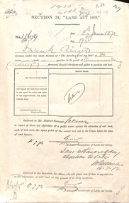
Document - Report, Section 31 Land Act 1869, 01/06/1872
Land application by Frank Ainger, referred to District Surveyor. Report by Mounted Constable Douglas with description of proposed use of land. Map of area. The area is on the corner of Whitehorse Road and Doncaster East Road.ainger, frank, douglas (mounted constable), assistant commissioner of lands and survey, whitehorse road, mitcham, doncaster east road, land settlement -
Whitehorse Historical Society Inc.
Pamphlet - Document, Maggs Family Reunion, 6/11/1994
Pamphlet on the Maggs Family reunion 6 Nov 1994 including background of Maggs Family, list of descendants, copy of marriage certificate and map of property.maggs family -
Whitehorse Historical Society Inc.
Document - Correspondence, Letter and Map Schwerkolt houses, 9/11/1993
... ' and 'new' houses. Letter and Map Schwerkolt houses Document ...Letter to W. Gray, Nunawading Historical Society from Glyn France enclosing map of Schwerkolt property and rough plan of old stone house drawn by Arthur Schwerkolt [map filed at A-SP 120]. Gives information about dates of building 'old' and 'new' houses.schwerkolt, arthur, schwerkolt, myra, france glyn, schwerkolt cottage -
 Whitehorse Historical Society Inc.
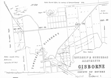
document - Map, Melbourne Metro, 1978
... document Map ...Collection of reproductions issued by the Public Record Office in 1978. Comprises: Allotments in the Black Forest, 1857; Township of Dandenong, 1856; Township and suburban allotments, Gisborne, 1857; Storing Yard allotments near the Melbourne Wharf, 1854; Town lots near the Railway Terminus, Melbourne, 1863; Parish of Prahran, 1853; Township of Sandridge, 1855; Township of Sunbury, 1857; River Yarra Yarra at the Queens Wharf, 1860.victoria. public record office, black forest, victoria, dandenong, gisborne, melbourne wharf, railway terminus, spencer street, melbourne, prahran, sandridge, sunbury, queens wharf -
 Whitehorse Historical Society Inc.
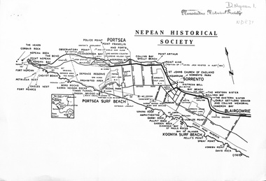
document - Map, Point Nepean, 1969
... by the Nepean Historical Society, 1969. Point Nepean document Map ...Map of Point Nepean showing historical sites, issued by the Nepean Historical Society, 1969.point nepean, victoria, nepean historical society -
 Whitehorse Historical Society Inc.
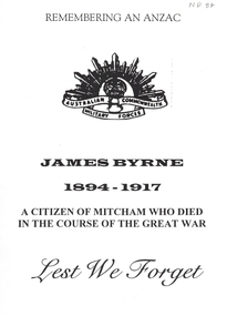
Document, Remembering an Anzac, 1/06/1997 12:00:00 AM
A Luther Collage Year 10 History essay which documents a visit to several war memorials and researches the history of James Byrne, a name on the Mitcham War Memorial. He had enlisted in 1915 and had been discharged dur to epilepsy. He reinlisted in 1916 and was sent to England where he died in camp. The reason given wassuffocation due to the influence of drink. The author surmises it may have been an epileptic fit. Maps & photographs included.byrne, james, ww1, war memorials -
 Whitehorse Historical Society Inc.
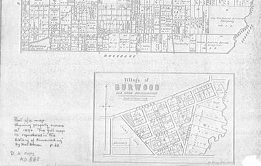
document - Map, Village of Burwood, 1892
... document Map ...Map on the village of Burwood.Village of Burwood : old name Ballyshanassy (with southern section of Nunawading). Area bounded by Chapman, Ireland and Evans Streets). Victorian Shire Map. co. 26 November 1892. Scale: 8 chains = 1 inch. The full map is reproduced in 'The History of Nunawading' by Niall Brennan, p. 62.Map on the village of Burwood.burwood, land settlement -
 Whitehorse Historical Society Inc.
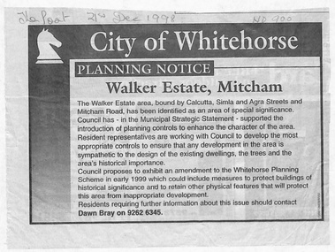
Document - Article, Planning Notice, 21/12/1998 12:00:00 AM
Planning Notice concerning the Walker Estate in Mitcham. Amendment to the Whitehorse Planning Scheme could include protection of buildings of historical significance, proposed early in 1999. Includes map of area.maps, walker estate, mitcham road, mitcham, calcutta street, mitcham, delhi street, mitcham, agra street, mitcham, simla street, mitcham, benares street, mitcham, meerut street, mitcham, the strand, mitcham, percy street, mitcham, stanley grove, mitcham, bray, dawn -
 Whitehorse Historical Society Inc.
Legal record - Document, Melbourne Metropolitan Planning Scheme, 1987
Explanatory Statement of Amendment 500 to Melbourne Metropolitan Planning Scheme, including map of area (South of Blackburn Station). To be exhibited from 2 October 1987 to 22 December 1987.roads and streets, victoria. ministry for planning and environment, city of nunawading, south parade, blackburn, blackburn road, blackburn, main street, blackburn -
 Whitehorse Historical Society Inc.
Document - Map, Roads, 1932
... Board, July - August 1932. Roads Document Map ...Map of roads on which Country Roads Board funds were spent, with request and response by Shire of Blackburn and Mitcham to the Country Roads Board, July - August 1932.roads and streets, victoria. country roads board, shire of blackburn and mitcham, terrara road, vermont -
Whitehorse Historical Society Inc.
Document, City of Nunawading Community Facilities, 1/06/1982 12:00:00 AM
Map of community facilities in the City of Nunawading 1982Map of community facilities in the City of Nunawading 1982 produced by the Burwood History Group. Scale: 3 1/2cm = 1 km.Map of community facilities in the City of Nunawading 1982burwood historical group, city of nunawading, maps -
Whitehorse Historical Society Inc.
Document, Map of Orchards, 1922
... of ND66 Map of Orchards Document Document ...1922 Map of orchards in the City of Nunawading, coloured green. This is a magnified localised view of ND66orchardists, orchards, blackburn, mitcham, tunstall, vermont, east burwood, tally ho