Showing 1104 items matching "information map"
-
 Melbourne Tram Museum
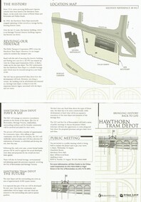
Pamphlet, Urban Land, Minster for Transport, Shirley Ramsay, "Hawthorn Tram Depot", Aug. 1998
Set of three documents concerning the redevelopment of the Hawthorn Tram Depot. .1 - Pamphlet - 3 fold DL, printed on fawn colour recycled paper, titled "Hawthorn Tram Depot" giving an outline of the project, a map and details of a public meeting. Has the City of Boroondara and Urban Land logos on it. Two copies held. .2 - Press Release - 5 A4 pages, stapled in top left hand corner titled "Heritage Future for Hawthorn Tram Depot", advising an announcement by the Minister for Transport Robin Cooper become a heritage tram depot. Gives information about the proposal. Has a historical background document attached. Dated 12/8/1998. .3 - Handwritten notes of the meeting by the donor, 3 ruled pages, stapled in the top left hand corner, dated 26/8/1998. Gives details of the project and discussions.trams, tramways, hawthorn tram depot, htt, tenders, heritage buildings -
 Melbourne Tram Museum
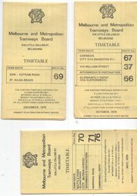
Ephemera - Timetable/s, Melbourne & Metropolitan Tramways Board (MMTB), "MMTB Tram Timetables", 1977 to 1978
Set of 6 MMTB Tram timetables, folded sheets, 8 sections, providing timetables for specific routes, day of week giving information on tram times at specific time points, route map, sections and fares and organisation address - 616 Little Collins St. Melbourne. All printed on yellow paper. 1. - Route 67, 37 and 66 - Carnegie - City via Swanston St (67), via William St (37) and Glenhuntly Depot (66) - dated Oct. 1978. .2 - Route 69 - Kew Cotham Road - St Kilda Beach dated Dec. 1978 .3 - Route 70, 71 and 76 - Wattle Park - Batman Ave, Arraign Road (Route 71) and Camberwell Depot (Route 76), dated May 1978 .4 - Route 72, 32 and 73 - Camberwell City via Swanston St (72), via William St (32) and Camberwell Junction (73) dated Sept, 1978. .5 - Route 82 - Moonee Ponds - Footscray - Highpoint West - dated Sept. 1977 .6 - Route 88, 14, 89 and 90, 96, 95 and 97 - East Preston via Bourke St (88), via Latrobe St (14), East Preston Bell St (89) and Northcote Dundas St (90) to the city and East Brunswick (96), Exhibition (95) and North Fitzroy (Park St), dated May 1978. .7 - Routes 48, 24, 40, 41, 29, 74, 76. 28 - July 1978 .8 - ditto - Weekends, July 1978, printed on green paper. .9 - Bus routes 284 (East Kew - Doncaster North) and 270 (East Kew - Shoppingtown) - dated August 1978trams, tramways, mmtb, timetables, melbourne, fares, route 14, route 32, route 37, route 66, route 67, route 69, route 70, route 71, route 72, route 73, route 76, route 82, route 88, route 89, route 90, route 95, route 96, route 97, route 48, route 24, route 40, route 41, route 29, route 74, route 76, route 28, route 284, route 270 -
 Melbourne Tram Museum
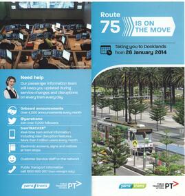
Pamphlet, Yarra Trams, "Route 75 is on the move", Jan. 2014
Pamphlet - 2 fold DL pamphlet, full colour, titled "Route 75 is on the move" advising of the re-routing of route 75 to Docklands from 26/1/2014 from the former terminus at the corner of Spencer and Latrobe St. Notes the 5th new E class now in operation. Has contact and general information on the rear. Includes a map.trams, tramways, route 75, docklands, yarra trams -
 Melbourne Tram Museum
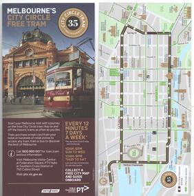
Pamphlet, Public Transport Victoria (PTV), "Melbourne's Free City Circle Tram", 8/2017, 1/2014
Pamphlet - DL size, titled "Melbourne's Free City Circle Tram" and on rear a map of the route and intersecting tram routes, with the route number "35" on both sides and major locations of interest. Has a photo of W6 961 in front of Flinders St station. Gives times for the service. Has Yarra Trams and PTV logos. Dated 08/17. .1 - as above, dated 1/2014 - similar information with a different layout.trams, tramways, city circle, yarra trams, docklands, route 35, tram 961 -
 Melbourne Tram Museum
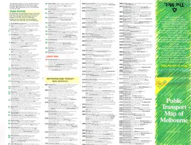
Map, The Met, "Public Transport Map of Melbourne" - "Effective August 1988", 1988
Map - Pocket size - folded - public transport map of Melbourne, printed in colour on art paper, showing public transport services in greater Melbourne, an index of localities. The City Saver area shown in detail. On the rear, route numbers, line maps of tram routes, train lines, outer metropolitan services, ticketing information, Transport Neighbourhoods, . Shows the St Kilda and Port Melbourne light rail lines. Price $2. Shows "The Met" logo. On front under The Met logo and above the scale bar is "Effective 1/7/1988".In ink in top left hand corner, "11" in a circle.trams, tramways, melbourne, map, routes -
 Melbourne Tram Museum
Newspaper, “From this…to this”, c1969
Newspaper clipping titled - “from this…to this” Undetermined source Melbourne’s trams and buses swing over to London numbering system from November 1 Route 10, West Preston, Wilcox – transport minister, new public transport map, tram services to be numbered from one to 100, eliminating numbers such as 2A, 4D and 9A. Tramway bus services to be numbered 200 to 300. Route information to follow London stye. Trams will display destination and main areas along the route on front of tram. Transport Minister, Mr Wilcox, said new system was part of policy to inform public about Melbourne's expanding street public transport services and to eliminate possible confusion. Conversion to new system to coincide with publication of pocket-size map of street public transport services. Map will show routes covered by trams and buses.trams, tramways, route 10, west preston, route numbers, destination roll -
 Melbourne Tram Museum
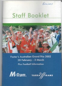
Book, M>Tram, Yarra trams, "Staff Booklet - Grand Prix 2002 - Plus football information", Feb. 2002
.1 - Book - 36 pages including cover with fold out map at the rear, centre stapled, titled "Staff Booklet - Grand Prix 2002 - Plus football information" . Gives details of event for tram crews, event program and transport map, including shunting details, announcements, bus services, boarding points, toilets, other alterations. Published with the Yarra Trams and M>Tram logos on the front and rear cover. Date: 28/2/2002 to 3/3/2002. .2 - Fold out circuit map for 2002 Grand Prix - full colour printed on gloss paper - 8 x 2 folds. showing location of the race track, how tram and rail routes operated, restricted parking area, Metcard, where taxis and limousines could park, bicycle racks. On the reverse side has a detailed map of Albert Park showing the various race facilities and grandstands. .3 - as for above - 2000 event Grand Prix.trams, tramways, grand prix, ptv, formula 1, albert park, maps -
 Melbourne Tram Museum
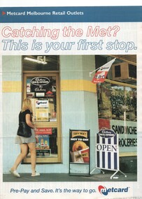
Pamphlet, VicTrip, "Catching the Met? - This is your first stop.", Apr. 1999
Pamphlet - four fold - special size - full colour titled "Catching the Met? - This is your first stop." giving the list of Metcard shops in central and suburban Melbourne, along with maps of the tram and train systems. The maps show both Yarra and Swanston trams with route numbers along with Bayside and Hillside trains and the various ticket zones at the time. The number of car parking spots at each station also shown. On the rear is general information about Metcard with ticket machines, and validators. List dated effective from April 1999.trams, tramways, maps, metcard, yarra trams, swanston trams, hillside trains, bayside trains, tickets -
 Melbourne Tram Museum
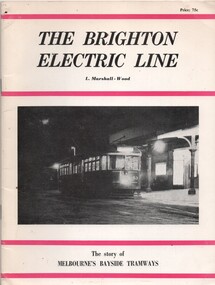
Book, Leon Marshall-Wood, "The Brighton Electric Line", 1966
Book - - the history of the Brighton Electric Line by Leon Marshall-Wood, published 1966, 3rd edition revised and enlarged. Gives a brief history of the electric tramway operated by the Victorian Railways between St. Kilda Station and the Brighton Beach railway station, that commenced operation in 1905. Also a short history of the Sandringham - Black Rock - Beaumaris - Cheltenham tram electric and horse tram lines. Includes maps, rolling stock and ticket notes. Published by Traction Publications. Has details of the AETA on the back cover and listing of some publications. See Reg Item 2062 for the 1st edition and 3400 for the second edition.Yields information about the Victorian Railways Melbourne tramways or street railways.Book - 40 pages including card coverstrams, tramways, vr, melbourne, brighton, st kilda, sandringham, black rock, horse trams -
 Melbourne Tram Museum
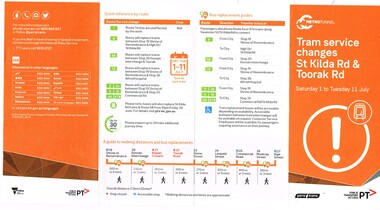
Pamphlet, Public Transport Victoria (PTV), "Tram service changes St Kilda Rd & Toorak Rd", Jun. 2017
.1 - Pamphlet - four fold - DL side four colour printed on off-white paper, titled "Tram service changes St Kilda Rd & Toorak Rd", advising intending passengers of the work between 1/7/2017 and 11/7/2017 to connect route 8 at Toorak Road West into St Kilda road the closure of the route via Park and Domain Road. Has a map, list of service changes, bus replacement guides and contact information. Has the logos of Metro Tunnel, Yarra Trams and PTV. .2 Pamphlet, printed and cut for use in trams around passenger hanging rails, titled "St Kilda Rd Tram and Bus service changes - Saturday 1 to Tuesday 11 July" - details bus replacement services and tram stops. Related to the main pamphlet - see image Set of five digital images taken at stop 25, Park St advising of the route diversion, replacement services and stop closure and two protest posters on fences nearby the stop about the Metro Tunnel project trucks using the local streets and the closure of the Park St / Domain Road tram line. .2 Pamphlet, printed and cut for use in trams around passenger hanging rails, titled "St Kilda Rd Tram and Bus service changes - Saturday 1 to Tuesday 11 July" - details bus replacement services and tram stops. Related to the main pamphlet.trams, tramways, park st, domain junction, metro tunnel, toorak rd, st kilda rd, tramway construction -
 Melbourne Tram Museum
Pamphlet, Yarra Trams, "Passenger Bulletin - Service Information Route 96 tram Priority trial - November 2011", October and November 2011
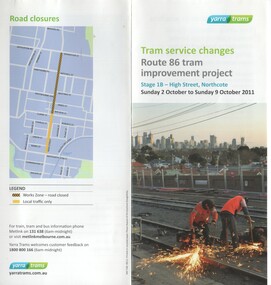
.1 - Pamphlet, 2 fold DL, full colour on gloss paper titled "Tram service changes - route 86 tram improvement project - Stage 1B - High St Northcote, Sunday 2 October to Sunday 9 October 2011", showing the road closures and alternative transport arrangements during the reconstruction of High St Northcote and the installation of the centre of the road island platform stops. Has 2 maps. Two copies held. .2 - Pamphlet - DL size, full colour on gloss paper, titled "Passenger Bulletin - Service Information Route 96 tram Priority trial - November 2011" Has photo of D2 5018 outside Museum of Victoria (IMAX sign) on front cover. Gives dates of the trials, that tram timetables had been temporarily change and that real time information could be obtained from TramTracker. .3 - Pamphlet, 3 fold DL, full colour on gloss paper titled "Tram service changes stage One - route 86 tram improvement project - High St Northcote, Saturday 9 July to Friday 15 July 2011." as for .1. Two copies held. All pamphlets have the Yarra Trams logos.trams, tramways, high st, northcote, tram stops, route 86, route 96, nicholson st, traffic lights, priority, tram d2 5018 -
 Melbourne Tram Museum
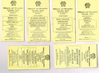
Ephemera - Timetable/s, Melbourne & Metropolitan Tramways Board (MMTB), "MMTB Tram Timetables", 1971 and 1973
Set of 20 MMTB Tram timetables, folded sheets, generally 10 sections, providing timetables for specific routes, day of week giving information on tram times at specific time points, route map, sections and fares and organisation address - 616 Little Collins St. Melbourne. All printed on yellow paper unless noted otherwise. .1 - Route 8 and 38, Toorak - City - August 1973 .2 - Route 9, 10 and 11, West Preston, Northcote - City - July 1973 .3 - Route - 1, 2, 4, 15, 16, 53, 55 - St Kilda Beach, south Melbourne Beach - City - September 1973 .4 - Route 1, 21, 15, 22 - Moreland, East Coburg - City - August 1973 .5 - Route 77, 78, 79 - Prahran - City, North Richmond, St Kilda Beach - October 1973 .6 - Route 88, 89, 90, 97 - East Preston, East Brunswick - City - October 1971 .7 - ditto - printed on green paper for Saturdays and Sundays. .8 - Route 59 - Essendon - City - June 1961 .9 - Route 8 - Toorak - City - Oct 1961, printed on yellow paper .10 - Routes 48, 40, 41, 37 and 74, 75, 76, 28 - North Balwyn or Burwood to City - March 1972 lists all the short routes by name and printed on yellow paper. .11 - Route 55, 56 and 68 - West Coburg - City or Domain Road - March 1972 - printed on yellow paper. .12 - Routes 48, 24, 40, 41, 29, 74, 75, 76 and 28 - North Balwyn or Burwood to City - March 1976 - printed on yellow paper. .13 - as for .12, Saturdays and Sundays - printed on green paper, ,14. - Route 19, 20 and 18 - Coburg - March 1972 - includes connecting bus to Upfield ,15 - Routes 1, 21, 15 and 22 - Moreland and East Coburg - March 1972 .16 - Routes 64, 65, 62 and 61 - East Brighton - June 1973 .17 - Route 3 - East Malvern - June 1973 ,18 - Route 5, 35 - June 1973 .19 - Route 82 - Footscray - Moonee Ponds - Oct. 1974 - bus Saturday afternoons and Sundays .20 - Route 67, 37 and 66 - Carnegie - June 1973trams, tramways, mmtb, timetables, melbourne, upfield, fares, route 1, route 2, route 3, route 4, route 5, route 8, route 9, route 10, route 11, route 15, route 16, route 18, route 19, route 20, route 21, route 22, route 38, route 35, route 37, route 53, route 55, route 66, route 67, route 77, route 78, route 79, route 88, route 89, route 90, route 96, route 97, route 59, route 48, route 40, route 41, route 37, route 74, route 75, route 76, route 82, route 28, route 55, route 56, route 68, route 29, route 24 -
 Melbourne Tram Museum
Ephemera - Timetable/s, Melbourne & Metropolitan Tramways Board (MMTB), "MMTB Tram Timetables", 1974
Set of 6 MMTB Tram timetables, folded sheets, generally 10 sections, providing timetables for specific routes, day of week giving information on tram times at specific time points, route map, sections and fares and organisation address - 616 Little Collins St. Melbourne. All printed on yellow paper unless noted otherwise. .1 - Route 48, 41, 40, 29, 74, 75, 76, 28 - North Balwyn and Burwood - City - Saturdays and Sundays - Feb. 1974, printed on green paper. .2 - Route 42, 23, 44, 45 and 37, Mont Albert - City - May 1974 .3 - Route 48, 41, 40, 29, 74, 75, 76, 28 - North Balwyn and Burwood - City - Feb. 1974 .4 -Route 59, 49, 52, 51, 81 - Essendon Airport - City - Oct. 1974 .5 - Route 70, 71 and 76 - Wattle Park - City - Feb. 1974 .6 - Route 72, 32 and 73 - Camberwell - City - Feb. 1974trams, tramways, mmtb, timetables, melbourne, fares, route 23, route 24, route 28, route 29, route 32, route 37, route 40, route 41, route 42, route 44, route 45, route 48, route 49, route 51, route 52, route 59, route 70, route 71, route 72, route 73, route 75, route 76, route 81 -
 Melbourne Tram Museum
Ephemera - Timetable/s, Melbourne & Metropolitan Tramways Board (MMTB), "MMTB Tram Timetables", 1975
Set of 9 MMTB Tram timetables, folded sheets, generally 10 sections, providing timetables for specific routes, day of week giving information on tram times at specific time points, route map, sections and fares and organisation address - 616 Little Collins St. Melbourne. All printed on yellow paper unless noted otherwise. .1 - Route 3 - East Malvern 3 - Bus Route Sundays Only, Feb. 1975 .2 - Route 5, 35 - Malvern - City .3 - Route 6, 7, 36 - Glen Iris - City .4 - Route 19, 18, 20 - North Coburg - City and Sundays only - Fawkner to Gowrie, Upfield - May 1975 .5 - Route 55, 56, 68 - West Coburg - City - Domain Road - May 1975 .6 - Route 57, 54, 60, 58 and 50 - West Maribyrnong - City - Feb. 1975 .7 - Route 64, 65, 62, 61 - East Brighton - City - June 1975 .8 - Route 66, 67 and 37 - Carnegie - City - June 1975 .9 - Route 82 - Footscray - Highpoint West - Moonee Ponds (Bus service Saturday afternoons and Sundays - November 1975. See Reg Item 2886 for a tramway check ticket for use on the Upfield line.trams, tramways, mmtb, timetables, melbourne, fares, upfield, bus replacement, route 3, route 5, route 6, route 7, route 18, route 19, route 20, route 35, route 36, route 37, route 50, route 54, route 55, route 56, route 57, route 58, route 60, route 61, route 62, route 64, route 65, route 66, route 67, route 68, route 82 -
 Melbourne Tram Museum
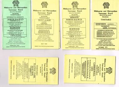
Ephemera - Timetable/s, Melbourne & Metropolitan Tramways Board (MMTB), "MMTB Tram Timetables", 1977
Set of 5 MMTB Tram timetables, folded sheets, generally 10 sections, providing timetables for specific routes, day of week giving information on tram times at specific time points, route map, sections and fares and organisation address - 616 Little Collins St. Melbourne. All printed on yellow paper unless noted otherwise. .1 - Route 9, 10, 11, 13 and 14 - West Preston - City - June 1977 .2 - Route 14, 88, 89, 90, 95, 96, 97 - East Preston and East Brunswick - City - Feb. 1977 .3 - ditto - Saturday and Sundays - printed on green paper. .4 - Routes 48, 24, 40, 41, 29, 74, 76. 28 - August 1977 .5 - Routes 42, 23, 44, 45, 47 - Mont Albert line - Sept 1977trams, tramways, mmtb, timetables, melbourne, fares, route 9, route 10, route 11, route 13, route 14, route 23, route 42, route 44, route 45, route 47, route 88, route 89, route 90, route 95, route 96, route 97, route 48, route 24, route 40, route 41, route 29, route 74, route 76, route 28 -
 Melbourne Tram Museum
Ephemera - Timetable/s, Melbourne & Metropolitan Tramways Board (MMTB), "MMTB Tram Timetables", 1980
Set of 12 MMTB Tram timetables, folded sheets, generally 10 sections, providing timetables for specific routes, day of week giving information on tram times at specific time points, route map, sections and fares and organisation address - 616 Little Collins St. Melbourne. All printed on yellow paper unless noted otherwise. .1 - Route 3 - East Malvern and Route 377 - Bus on Sunday only - June 1980 .2 - Route 8 and 88 Toorak - December 1980 .3 - Route 9 and 14 - Northcote - City - Dec. 1980 .4 - Route 42, 23, 44, 45, 47 - Mont Albert - City - Nov. 1980 .5 - Route 61, 62, 64, 64 - East Brighton - City - July 1980 .6 - Route 37, 66 and 67 - Carnegie - City - July 1980 .7 - Route 10, 11, 13 - West Preston - City - November 1980 .8 - Route 69 - St Kilda Beach - Kew - Nov. 1980 .9 - Route 75, 74, 76 and 28 - East Burwood - City - Oct. 1980 .10 - Route 96, 95, 97 - East Brunswick - City - September 1980. .11 - Route 15, 22 - Moreland - City - December 1980 ,12 - Route 1 & 21 - East Coburg - City - December 1980trams, tramways, mmtb, timetables, melbourne, fares, bus replacement, route 1, route 3, route 8, route 9, route 10, route 11, route 13, route 14, route 15, route 21, route 22, route 23, route 28, route 37, route 38, route 42, route 44, route 45, route 47, route 61, route 62, route 64, route 61, route 66, route 67, route 69, route 74, route 75, route 76, route 95, route 96, route 97, route 377 -
 Melbourne Tram Museum
Ephemera - Timetable/s, Melbourne & Metropolitan Tramways Board (MMTB), "MMTB Tram Timetables", 1981
Timetables for specific routes, day of week giving information on tram times at specific time points, route map, sections and fares and organisation address - 616 Little Collins St. Melbourne. All printed on yellow paper unless noted otherwise. .1 - Route 10, 12, 17 - South Melbourne - St Kilda Beach - city - Jan. 1981 .2 - Route 5, 35 - Malvern - City .3 - Route 6, 7, 36 - Glen Iris - City - July 1981 .4 - Route 1, 2, 4 - South Melb. Beach - City - Feb. 1981 .5 - Route 70, 71, 76 - Wattle Park - City - April 1981 .6 - Route 72, 32, 73 - Camberwell - city - April 1981 .7 - Route 77, 78, 79 - Prahran - city, North Richmond - St Kilda Beach - April 1981 .8 - Route 82, Footscray - Highpoint West - Moonee Ponds - Bus route 223, Saturday afternoons and Sundays - Jan. 1981 9 - Route 15 & 16, 53 & 55 - St Kilda Beach - Via Swanston St or William St - Feb. 1981 10 - Routes 6, 36 and 7 - Glen Iris, July 1981Yields information about MMTB Tram timetables 1981Set of 10 MMTB Tram timetables, folded sheets, generally 10 sections, trams, tramways, mmtb, timetables, melbourne, fares, bus replacement, route 1, route 2, route 3, route 4, route 5, route 6, route 7, route 10, route 12, route 17, route 32, route 35, route 36, route 70, route 71, route 72, route 73, route 76, route 77, route 78, route 79, route 82, route 223, route 15, route 16, route 53, route 55 -
 Melbourne Tram Museum
Ephemera - Timetable/s, Melbourne & Metropolitan Tramways Board (MMTB), "MMTB Bus Timetables", 1981
Timetables for specific routes, day of week giving information on tram times at specific time points, route map, sections and fares and organisation address - 616 Little Collins St. Melbourne. All printed on yellow paper unless noted otherwise. .1 - Route 215, 216, 217, 219, 229, 218 - Deer Park, Sunshine, Footscray, City - November 1981 .2 - Route 233, 235 and 237 - Fisherman's Bend - City November 1981 .3 - Route 256, 251, 253, 254, 252, 255 - Latrobe University, Northland, West Heidelberg, North Carlton - City - April 1981 .4 - Route 290 - Box Hill - Blackburn North - March 1981 5 - Williamstown Road, Footscray, Ballarat Rd and Highpoint West - Route 223 - April 1981 6 - Clifton Hill, Esternwick, Point Ormond, St Kilda Junction - routes 246, 247 and 248 - Feb. 1981Yields information about MMTB bus services 1981.Set of 6 MMTB Bus timetables, folded sheets, generally 10 sections.trams, tramways, mmtb, timetables, melbourne, fares, buses, deer park, sunshine, footscray, fisherman's bend, latrobe university, northland, heidelberg, carlton, box hill, blackburn, ballarat road, williamstown road, highpoint, clifton hill, elsternwick, point ormond -
 Melbourne Tram Museum
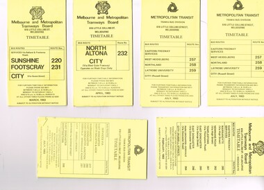
Ephemera - Timetable/s, Melbourne & Metropolitan Tramways Board (MMTB), "MMTB Bus Timetables", 1983
Timetables for specific routes, day of week giving information on tram times at specific time points, route map, sections and fares and organisation address - 616 Little Collins St. Melbourne. All printed on yellow paper unless noted otherwise. .1 - Route 220 and 231 - Sunshine - Footscray - City - March 1983 .2 - North Altona - City via West Gate Freeway - April 1983 .3 - Route 257, 258, 259 - West Heidelberg, Northland, Latrobe University - City - July 1983 .4 - ditto .5 - Route 265, 262, 261, 260, 266, 264 - Warrandyte, Templestowe, Doncaster, Park Orchard - Donvale - City - Feb. 1983 .6 - Route 277, 280, 299, 281 and 268 - Warrandyte, East Doncaster, Donvale, Shoppingtown - July 1983 .7 - Route 287, 286, 302, 303 Box Hill, Mitcham, East Doncaster, Mitcham, Ringwood - June 1980 .8 - ditto - but November 1983 .9 - Route 313, 314, 315, 316 - Warrandyte, Park Orchards, Mitcham - Jan. 1983 .10 - as for .8 11 - Routes 265, 262, 261,260, 266 and 264 - Warrandyte - Eastern Freeway, Templestowe, Park Orcards - Feb. 1983 12 - Routes 277, 280, 281 and 268 - East Doncaster, Donvale, City and Shoppingtown - Jan. 1983 Items .3, .4, .6, .8 and .10 are headed "Metropolitan Transit", rest MMTB.Yields information about MMTB Bus Services 1983Set of 12 MMTB or Metropolitan Transit Bus timetables, folded sheets, generally 10 sections.trams, tramways, mmtb, timetables, melbourne, fares, buses, deer park, sunshine, footscray, latrobe university, northland, heidelberg, box hill, warrandyte, doncaster, donvale, mitcham, ringwood, park orchards -
 Melbourne Tram Museum
Ephemera - Timetable/s, Metropolitan Transit Authority (MTA), "MMTB Bus Timetables", 1984
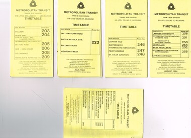
Set of 5 Metropolitan Transit Bus timetables, folded sheets, generally 8 or 10 sections, providing timetables for specific routes, day of week giving information on tram times at specific time points, route map, sections and fares and organisation address - 616 Little Collins St. Melbourne. All printed on yellow paper unless noted otherwise. .1 - Route 203, 204, 205, 206, 208. 209 - Bulleen, North Kew, Belford Road, Kew, Collingwood and Nicholson and Johnson St - City - April 1984 .2 - Route 223 - Williamstown Road, Footscray Railway Station, Ballarat Road and Highpoint West - July 1984 .3 - Route 246, 247, 248 - Clifton Hill, Elsternwick, Point Ormond and St Kilda Junction - July 1984 .4 - Route 256, 251, 253, 254, 252, 255 - Latrobe University, Northland, West Heidelberg - City - Aug./ 1984 .5 - Route 277, 280, 299. 281 and 268 - services via East Doncaster, North Balwyn and Kew - Warrandyte, Donvale, Shoppingtown - August 1984trams, tramways, metropolitan transit, timetables, melbourne, fares, buses, footscray, latrobe university, northland, heidelberg, warrandyte, doncaster, donvale, bulleen, north kew, williamstown rd, highpoint, clifton hill, elsternwick, point ormond, st kilda junction -
 Melbourne Tram Museum
Ephemera - Timetable/s, Metropolitan Transit Authority (MTA), "MMTB Bus Timetables", 1982
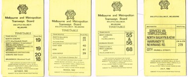
Set of 7 MMTB Tram and Bus timetables, folded sheets, generally 8 or 10 sections, providing timetables for specific routes, day of week giving information on tram times at specific time points, route map, sections and fares and organisation address - 616 Little Collins St. Melbourne. All printed on yellow paper unless noted otherwise. .1 - Routes 19, 20, 18 - North Coburg, and bus service to Fawkner, Gowrie, Upfield - nightly Monday to Saturday and all day Sunday - Oct. 1982 .2 - Route 48, 24, 40, 41, 29 - North Balwyn - City - March 1982 .3 - Route 55, 56 68 - Sunday only via Elizabeth St - March 1982 .4 - Route 276, 278 and 279 - Services via Templestowe, Warrandyte and Newmans Road - City - July 1982 .5 - Route 57, 357 (bus Sundays only), 54, 60, 58, 50 - West Maribyrnong - City - Jan. 1982 .6 - Route 59, 49, 52, 51 and 81 - Essendon Airport - City - March 1982 .7 - Route 203, 204, 205, 206, 208. 209 - Bulleen, North Kew, Belford Road, Kew, Collingwood and Nicholson and Johnson St - City - Sept. 1982trams, tramways, mmtb, timetables, melbourne, fares, buses, bus replacement, trams, upfield, route 18, route 19, route 20, route 24, route 29, route 40, route 41, route 48, route 49, route 50, route 52, route 51, route 54, route 55, route 56, route 57, route 58, route 59, route 60, route 68, route 81, route 357, warrandyte, doncaster, templestowe, kew -
 Melbourne Tram Museum
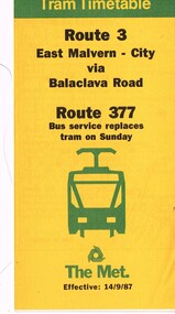
Ephemera - Timetable/s, The Met, "The Met Tram Timetable", Mar. 1987
The Met Tram timetables, folded sheets, generally 8 sections, providing timetables for specific routes, day of week giving information on tram times at specific time points, route map, sections and fares and phone contact numbers. Route 3 - East Malvern - City via Balaclava Road and Route 377 - bus service - dated 14/9/1987.trams, tramways, the met, timetables, melbourne, fares, route 3, route 377, bus replacement -
 Melbourne Tram Museum
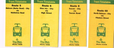
Ephemera - Timetable/s, The Met, "The Met Tram Timetable", 1987 and 1988
Set of 9 The Met Tram timetables, folded sheets, 8 -10 sections, providing timetables for specific routes, day of week giving information on tram times at specific time points, route map, sections and fares and phone contact numbers. Route 5 - Malvern (Burke Road) - City via Wattletree Road - June 1988 Route 6 - Glen Iris - City via High St - June 1988 Route 8 - Toorak - City - June 1988 Route 48 - North Balwyn - City via Flinders St - Oct. 1988 Route 67 - Carnegie - City - Sept. 1987 Route 86 - Bundoora - City via Preston - Aug. 1988 Route 72 - Camberwell - City via Malvern Road - June 1988 Route 75 - East Burwood - City via Flinders St - Feb. 1988 Route 96 - East Brunswick - St Kilda Beach (Light Rail) - Oct 1988trams, tramways, the met, timetables, melbourne, fares, route 5, route 6, route 8, route 48, route 67, route 86, route 72, route 75, route 96 -
 Melbourne Tram Museum
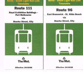
Ephemera - Timetable/s, The Met, "The Met Tram North-South Light Rail Line Timetable", Oct. 1988
Set of 2 The Met Tram timetables, folded sheets, 7 or 10 sections, providing timetables for specific routes, day of week giving information on tram times at specific time points, route map, sections and fares and phone contact numbers. Titled "The Met Tram North-South Light Rail Line Timetable" Issued at the time of the opening of the light rail services along the former St Kilda and Port Melbourne railway lines. .1 - Route 96 - East Brunswick - St Kilda Beach via Bourke St city - 24/10/1988 .2 - Route 111 - Royal Exhibition Buildings - Port Melbourne via Bourke St City - 24/10/1988trams, tramways, the met, timetables, melbourne, fares, light rail, route 96, route 111, conversion, port melbourne, st kilda, east brunswick -
 Melbourne Tram Museum
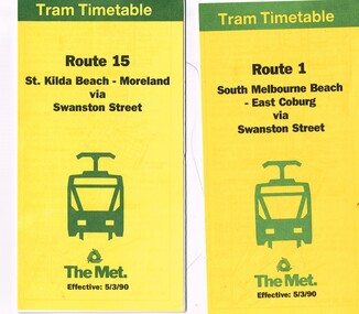
Ephemera - Timetable/s, The Met, "The Met Tram Timetable", Mar. 1990
Set of 2 The Met Tram timetables, folded sheets, 10 sections, providing timetables for specific routes, day of week giving information on tram times at specific time points, route map, sections and fares and phone contact numbers. Titled "The Met Tram Timetable" .1 - Route 1 - South Melbourne Beach - East Coburg - March 1990 .2 - Route 15 - St Kilda Beach - Moreland - March 1990trams, tramways, the met, timetables, melbourne, fares, route 1, route 15 -
 Melbourne Tram Museum
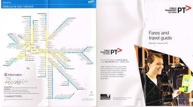
Pamphlet, Public Transport Victoria (PTV), "Fares and Travel Guide", Dec. 2012
Pamphlet "Fares and Travel Guide" - effective Jan. 2013. .Book - DL size, red coloured covers 20 pages, centre stapled, colour printed on gloss paper, has table of contents and fold out map of the tram and rail system. Givers details on travelling conditions, Myki tickets, fares and zones, touching on, refunds, Passenger information, Hours of Operation and Translated information. Has the PTV Logos. Two copies heldtrams, tramways, tickets, fares, metro trains, guides, yarra trams, ptv, tram 5013 -
 Melbourne Tram Museum
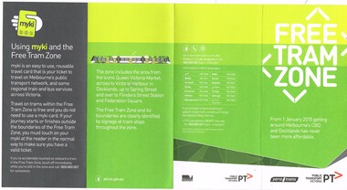
Pamphlet, Public Transport Victoria (PTV), 'Free Tram Zone", Dec. 2014
Pamphlet - DL size, 4 fold, printed on off white paper, titled "Free Tram Zone", providing information about the introduction of the free tram zone in the Melbourne CBD and a map. Applicable from 1/1/2015. Has contact details, Yarra Trams, PTV logos and Victorian Government logo on the rear. Notes the use of Myki cards. 2 copies held.trams, tramways, free tram, yarra trams, maps, melbourne, myki -
 Melbourne Tram Museum
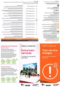
Pamphlet, Yarra Trams, "Formula 1 Grand Prix Tram Services Changes Saturday 25 to Sunday 26 March 2017", Feb. 2017
Pamphlet - 6 fold DL from an A3 full colour sheet titled "Formula 1 Grand Prix Tram Services Changes Saturday 25 to Sunday 26 March 2017" printed for public distribution. Gives information on tram route changes, contact details, how to get to Albert Park, circuit map and service frequency. Produced by PTV, Yarra Trams and Victorian State Government - has their logos on the sheet.trams, tramways, yarra trams, grand prix, map, public transport -
 Melbourne Tram Museum
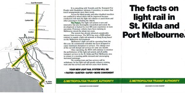
Pamphlet, Metropolitan Transit Authority (MTA), "The facts on light rail in St Kilda and Port Melbourne", c1987
Three fold full colour pamphlet - approx. A5 size, titled "The facts on light rail in St Kilda and Port Melbourne", published by the MTA outlining the proposed conversion of the St Kilda and Port Melbourne rail lines. Gives information on current passengers, proposed routes, plans. Map shows the proposed lines to be converted, and the Nicholson St tram line. Outlines issues, such as disability access, Yooralla and notes Hong Kong contract. C1987.trams, tramways, light rail, conversion, st kilda, port melbourne -
 Melbourne Tram Museum
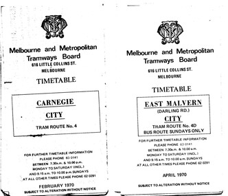
Ephemera - Timetable/s, Melbourne & Metropolitan Tramways Board (MMTB), "MMTB Tram Timetables", 1970
Set of 12 MMTB Tram timetables, folded sheets, 10 sections, providing timetables for specific routes, day of week giving information on tram times at specific time points, route map, sections and fares and organisation address - 616 Little Collins St. Melbourne. .1 - Route 4 - Carnegie - City - Feb. 1970. .2 - City Route 4D - East Malvern - April 1970 - notes a bus route on Sundays only .3 - Routes 55 and 56 - West Coburg - City via Domain Road and William St - Sept. 1970 .4 - Route 65 and 64 - East Brighton - City - April 1970 .5 - Route 1, 2, 15 and 16, St Kilda Beach, South Melbourne Beach and City - March 1970. .6 - Route 5 - Malvern Burke Road - City - April 1970 .7 - Routes 48 and 74 - North Balwyn - Burwood - City September 1970 .8 - Route 59 - Essendon - city - July 1970 .9 - Routes 88 and 96 - East Preston - East Brunswick - City - March 1970 .10 - Route 82 - Footscray - Moonee Ponds - Feb 1970 .11 - Routes 48 and 74 - North Balwyn - Burwood - City September 1970 - Saturdays and Sundays, printed on pink paper. .12 - Routes 88 and 96 - East Preston - East Brunswick - City - March 1970 - Saturdays and Sundays, printed on pink paper.trams, tramways, mmtb, timetables, melbourne, fares, route 4, route 4d, route 55, route 56, route 64, route 65, route 1, route 2, route 15, route 16, st kilda beach, carnegie, east malvern, west coburg, east brighton, south melbourne beach, route 5, route 48, route 74, route 88, route 59, route 96, route 82