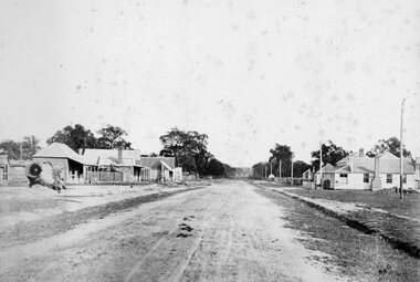
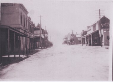
Showing 1313 items
matching looking west
-
 Ballarat Tramway Museum
Photograph - Digital image, Charles Rudd, c1890?
... from the Nicholl and Alan building looking west along Sturt St... building looking west along Sturt St. Shows the buildings along ...Yields information about the appearance of Sturt St following the introduction of the horse trams.Digital image from the State Library of Victoria website image No. H39558/12, a Charles Rudd photograph showing a view from the Nicholl and Alan building looking west along Sturt St. Shows the buildings along either side of Sturt St and a horse tram descending the hill. Very little other traffic in the photograph. Has signs for "C. Huck - The Queen's studio photo" and "Morrey and Murray", the Cash Drapers on the Ballarat Mechanics Institute building. Note the caption of the photograph is incorrect. See image btm7019i2.pdf for the SLV link - correct as of 31-12-17. See image i2 for a more detailed photograph.trams, tramways, grenville st, sturt st, horse trams -
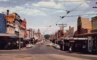 Ballarat Tramway Museum
Photograph - Digital Image, Bridge Street
... by Roger. See btm6304doc.pdf Image looking west along Bridge... by Roger. See btm6304doc.pdf Image looking west along Bridge St ...Yields information about the appearance of Bridge St early 1960's and the buildings on either side. Shows the festoon lighting.Digital Copy of a photograph sourced by Roger Greenwood as part of his work on the production of a Video Tape on Ballarat's trams. Photographer and source details not provided by Roger. See btm6304doc.pdf Image looking west along Bridge St Ballarat with the festoon lighting in position. See Reg Item 6303i. This image appears to be early 1960's, possibly a bogie tram with yellow stripping at the Grenville St end, but not the large white stripe. Has the Stones Corner and The State Bank buildings in the view. Photo from a postcard, published c1967 as advised in the e-mail of 20/7/15. Print in box 13 trams, tramways, bridge st, stones corner, main road -
 Melbourne Tram Museum
Photograph - Set of 7 Colour Print/s, Steven Altham, 27/12/2001 12:00:00 AM
... . .2 - View from Power St extension looking west. .3 -View... - View from Power St extension looking west. .3 -View from ...Set of 7 colour prints of the re construction of the Hawthorn Tram Depot to the Watermark Apartments. All taken on 27-12-2001. .1 - view from the intersection of Power and Wallen Road, looking to the original building with scaffolding. .2 - View from Power St extension looking west. .3 -View from Wallen Road showing new block and tram track into the depot. .4 - View of the original building from Wallen Road. .5 - View from the gardens looking north showing the new block. .6 - ditto .7 - ditto Colliers Jardine and Bovis Lend Lease signs in the photos.All have details of photograph on rear and photographers name.trams, tramways, watermark apartments, hawthorn depot, construction, tram depot -
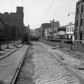 Melbourne Tram Museum
Negative - Set of 2, Possibly Geoff Grant, c1950
... layer, a building selling Skoda cars, .2 - Looking west from... layer, a building selling Skoda cars, .2 - Looking west from ...Set of two Black and white negatives of track construction in La Trobe St during 1950. .1 - Looking east from Queen St. Has the Argus building in the view. Both tracks have been constructed and the concrete foundation poured pending the top asphalt layer, a building selling Skoda cars, .2 - Looking west from Queen St with a tram crossing in the background in William St. Photo shoes the method of track construction - timber sleepers with the rail bolted to the sleeper. Pending concerting. In the background is The Mint and terrace houses on the left. There is a billboard for 1949 movie, "The Bribe". Photo not in Wal Jack Melbourne album.trams, tramways, la trobe st, track construction, trackwork, queen st -
 Melbourne Tram Museum
Photograph - Black & White Photograph/s, Melbourne & Metropolitan Tramways Board (MMTB), early 1978
... Black and white photograph of Bourke St Mall, looking west..., looking west from the north side. Has two W class trams ...Black and white photograph of Bourke St Mall, looking west from the north side. Has two W class trams in the photo and many people. Trams have the destination of East Preston and East Brunswick Blyth St. In the background are buildings for Dunklings. Rear of photo dates it as c1975. The Mall opened in Feb. 1978 (Melbourne Tramways Timeline book - Barry George et al), so possibly soon after opening. See also Reg Item for a photo of Z1 in Bourke St prior to the Mall being built. Second copy added 3-6-16 from donation of Geoff Warburton.On rear in ink "Bourke St Mall c/1975"trams, tramways, w class, bourke st, mmtb -
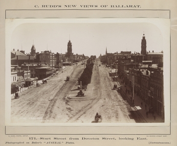
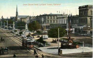
 Ballarat Tramway Museum
Postcard - Folder set, Valentine & Sons Publishing Co, "Photographic View Booklet Ballarat", early 1920's
... Hall 11. Sturt St, Looking West, with ESCO car crossing Sturt..., Looking West, with ESCO car crossing Sturt St from Lydiard St 12 ...Set of 15 black and white views of Ballarat printed on a folded strip, glued within a grey colour cardboard folder, titled "Photographic View Booklet Ballarat". Booklet printed with an address area within a leaf and on the rear, an area where the sender could write their name. Produced by The Valentine Publishing Co. Pty Ltd Melbourne. The rear has a slit on the rear cover that allowed the folder to be secured. Pictures are: 1. Statuary, Ballarat Gardens - the flight from Pompeii 2. Sturt St looking west from the Town Hall 3. Eureka Stockade monument 4. Lily Pond and Statuary House, Botanic Gardens 5. Sturt St from Lydiard St (with ESCo 17) 6. Lily Pond, Botanic Gardens 7. Sturt St from Grenville St with two ESCo trams in the view - similar image to btm761, but note Town Hall tower has been modified with a balcony. 8. The Old Curiosity Shop 9. Landing Place, Lake Wendouree 10. View from the Town Hall 11. Sturt St, Looking West, with ESCO car crossing Sturt St from Lydiard St 12. Along Lake Wendouree 13. In the Gardens 14. The Avenue of Honor (14 miles long) (Honour) 15. Post Office and Lydiard St Made early 1920's given The Avenue of Honor and other photographs with motor cars in the photo. trams, tramways, ballarat, postcards, sturt st, town hall, post office, gardens, esco -
 Canterbury History Group
Photograph - View from the spire of the new Canterbury Baptist Church, 1962
... the album kept at the church, of the view of Canterbury looking..., of the view of Canterbury looking to the west from the spire ...Black and white photograph copied by Jan Pigot from the album kept at the church, of the view of Canterbury looking to the west from the spire of the new Canterbury Baptist Church, 1962canterbury, canterbury road, canterbury baptist church, balwyn road, churches, canterbury presbyterian church, soldiers memorial hall, neighbourhood houses -
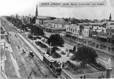 Ballarat Tramway Museum
Photograph - Black & White Photograph/s, 1906
... Black and white photograph of Sturt St. looking west from.... Ballarat Black and white photograph of Sturt St. looking west from ...Black and white photograph of Sturt St. looking west from Town Hall 1906. Shows a ESCo tram hauling an ex-horse trailer (spelt "trailer"). Has some other horse drawn vehicles in photo and a number of pedestrians. Shows the newly formed tramway road surface, poles etc. Has "Snows" store sign on left hand side of photograph and buildings along the north side of the Sturt St. Other buildings shown are William Day & Son, Walter Connell, Anderson & Morse coach builders. See also Reg Item No. 1671 for the same item, but with out the typed note stuck on the top edge.trams, tramways, esco, sturt st., ballarat -
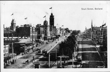 Ballarat Tramway Museum
Photograph - Black & White Photograph/s, 1900's mid to late?
... , taken from a Grenville St. building looking west. Shows two... a Grenville St. building looking west. Shows two ESCo trams, possibly ...Black and white photograph of Sturt St. Ballarat, east end, taken from a Grenville St. building looking west. Shows two ESCo trams, possibly No. 11 eastbound and 17?, westbound. Street track looks new, flags on many buildings in photo, good view of buildings on the West side of the street. Has caption "Sturt Street, Ballarat" top right hand corner and number "300,975(JW), bottom right hand corner. Photo mounted on black faced cardboard for display purposes. Has had tape on rear card, since removed. Part of photo also used in a Ballarat Business brochure, see Reg. Item No. ?trams, tramways, ballarat, sturt st, street scenes, esco , tram 11 (esco) and 17? (esco) -
 Ballarat Tramway Museum
Photograph - Colour Photograph/s - set of 3, Warren Doubleday, 27/12/1998 12:00:00 AM
... Pleasant St., looking west. Photo used in September 2000 issue... locations. .1 - Sturt St West from Pleasant St., looking west ...Set of three colour photographs taken by Warren Doubleday on 27/12/1998 of Museum activities and works. On Kodak paper. Used in Fares Please! as comparison with photos in tramway operating days at the same locations. .1 - Sturt St West from Pleasant St., looking west. Photo used in September 2000 issue of Fares Please! .2 - Albert St Sebastopol looking south, near Ophir St where the tramway crossed Albert St. Photo used in Mar. 1999 issue of Fares Please! .3 - Albert St, Sebastopol / Skipton St at intersection with Rubicon St. looking south with Eclipse Ford Motors on left side.On back of photos in ink "27/12/98"albert st, sebastopol, skipton st, sturt st. west -
 Ballarat Tramway Museum
Photograph - Digital image, c1930
... of a postcard - titled "Sturt St Ballarat", looking west along Sturt St... the buildings, buildings and scene in Sturt St looking west from ...Yields information the buildings, buildings and scene in Sturt St looking west from Grenville St.Digital image from the Wal Jack Ballarat Album of a postcard - titled "Sturt St Ballarat", looking west along Sturt St from Grenville St., Valentine Series 1499. Wal notes "old type on left, present No. 26 on Right with Sebastopol type in background. In the photo are advertisements or buildings for: Reed and William, Thornton for photos, S&N Sior, W Brown & Co, Cycle and Motor, Singer, Bailey Bros Cash Butchers, Geo White, Robur Tea, Davies Bread, Carlyon's Hotel and Richmond Wal has dated the photo about 1930 on his album notes. For rear of postcard - see image i2.In bottom right hand corner has the "2 Vic Rail Photo".trams, tramways, esco, sturt st, dawson st, tram 26 -
 Eltham District Historical Society Inc
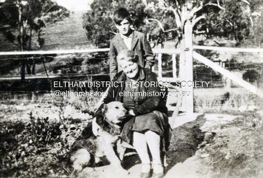
Photograph, Beatrice Arrowsmith (nee Quigley) and Robert Arrowsmith and King the dog at front gate of 523 Main Road, Eltham
... View is looking south west from inside the front gate. Main...View is looking south west from inside the front gate. Main ...View is looking south west from inside the front gate. Main Road is running across the picture just past the trees and the open area is where the current day Fitzsimons Lane runs. Porter street is adjacent to the property on the right of image. Robert was a POW in ChangiShows the area of Fitzsimons Lane prior to developmentBlack and white photograph - digital fileeltham, main road, fitzsimons lane, porter street, castledine, beatrice arrowsmith (nee quigley), king (dog), robert arrowsmith, joan castledine collection -
 Bendigo Historical Society Inc.
Postcard - SHAMROCK HOTEL, BENDIGO
... Postcard, color. Image shows Shamrock Hotel, looking from..., looking from west side of Pall Mall. Iron fence in foreground ...Postcard, color. Image shows Shamrock Hotel, looking from west side of Pall Mall. Iron fence in foreground, cars in street. On back of card: ' Shamrock Hotel, Bendigo, Victoria. The present Shamrock Hotel was built in 1897, and has become one of the city's best loved land marks'Nu Color Vuebendigo, buildings, shamrock hotel, bendigo, shamrock hotel, pall mall -
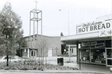 Whitehorse Historical Society Inc.
Photograph, Corner Edward Street & Whitehorse Road, Mitcham, 2000
... of Edward Street & Whitehorse Road looking North West, from L-R... looking North West, from L-R: Anglican Church of Christ; Church ...Produced as one of a series of 24 prints commissioned by Nunawading & District Historical Society -|Theme: Intersections of Mitcham and Nunawading 2000/2001.|See also Series by P. Simmenauer on the same theme.Black and white photograph - print and negative of Corner of Edward Street & Whitehorse Road looking North West, from L-R: Anglican Church of Christ; Church Hall in weatherboard. In streetscape (Whitehorse Road) Mitcham Hot Bread Kitchen, Coca Cola Sign and Chinese calligraphy on shop sign.christ church anglican church, mitcham, mitcham hot bread shop, edward street -
 Ballarat Tramway Museum
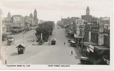
Postcard, Valentine & Sons Publishing Co, Sturt Street from Lydiard St Ballarat, c1912
... . looking west from the southeast corner of Lydiard St... of the intersection of Sturt St. looking west from the southeast corner ...Printed colour postcard of the intersection of Sturt St. looking west from the southeast corner of Lydiard St. In the bottom left-hand corner is the number "300479" and the initials "JV"? within a circle. In the view are Crockers and the Art Gallery Association buildings. The later became the SEC Ballarat city offices. Image possibly taken c1912 as the trams appear to have driver's windows. Car featured in photo is No. 17. Note on the position of the rear lifeguard area of the tram is the word "Summerscales". Titled "Sturt St from Lydiard St Ballarat" centrally along the top of the card. The printer/publisher of the card is "The Valentine & Sons Publishing Co. Ltd, Melbourne and Sydney". In the stamp area is the number "20-2". Two copies held. Yields information about Ballarat and Sturt St in c1912Postcard - coloured, divided back, Valentine & SonsOn rear in ink "No. 17 old type, about 1912", Ken Magor stamp and letters "WJ" underneath.trams, tramways, esco, sturt st, postcards, lydiard st, tram 17 -
Glenelg Shire Council Cultural Collection
Photograph - Sheet of 12 contact prints - Various historic Portland buildings and Landmarks, c. 1970
... ) Portland Show (g) North side Julia Street looking west Bank...) Portland Show (g) North side Julia Street looking west Bank ...Sheet of 12 contact prints of rephotographed photographs. Measurements (a) (e)-(h) (j-i)(b) 3.7 x 55 x 3.7 Framed 5.2 x 44.5 x 4 (a) Looking south across beach at Dutton Way (b) S.S. 'Eumeralla' (c) Construction of railway pier (d) Jackass Fern Gully (e) 'Kingsley' (f) Portland Show (g) North side Julia Street looking west Bank of Australiasia (h) Henty Street looking east from Percy Street (i) Old Post Office (j) All Saints Catholic Church (k) View from Henty Street - old Town Hall (l) Opening 3rd BathsFront: (a) 'Dutton Way 1900 (b) 'S.S. Eumeralla' (c) Construction of Railway Pier (f) Portland Show (h) Henty Street, Portland (i) (B) -
Port Melbourne Historical & Preservation Society
Photograph - Photograph board, Seven aerial views of J Kitchen & Sons site, Port Melbourne, J Kitchen & Sons Pty Ltd. Port Melbourne 1951, 1951
... - directly above kitchens Photo 5 - looking West including the Yarra... Photo 4 - directly above kitchens Photo 5 - looking West ...Large brown cardboard with seven (7) B&W aerial photographs pasted on it. Taken in 1951. Photo 1 - South East direction with Boundary Street in foreground, Kitchens buildings and Football Ground (cricket being played) Photo 2 - South West direction towards the Bay showing Station and Princes Piers, with ships in the distance. Photo 3 - almost directly above Kitchens Photo 4 - directly above kitchens Photo 5 - looking West including the Yarra River Photo 6 - looking North with Kitchen's storage and football ground in foreground Photo 7 - looking north east with football ground in foregrpound left and Yarra River top right.industry - manufacturing, built environment - industrial, piers and wharves - princes pier, piers and wharves - station pier, sport - australian rules football, sport - cricket, sport - recreational grounds, j kitchen & sons pty ltd, port melbourne football and cricket ground, north port oval -
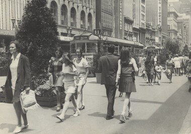
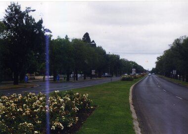
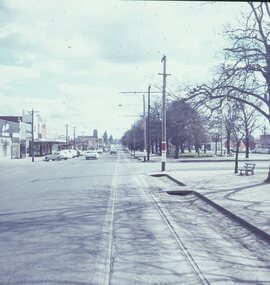 Ballarat Tramway Museum
Slide - 27 mm sq slide/s - set of 5, Lilian Butler, Sturt Street, 1971
... - Sturt St looking west, south side from Windermere St. .2 - ditto... - Sturt St looking west, south side from Windermere St. .2 - ditto ...Yields information about Sturt St between Lydiard St and Ripon St.Set of 5 AGFA slides - blue and white plastic mounts: 1 - Sturt St looking west, south side from Windermere St. .2 - ditto from Dawson St, shows tram stop sign and end of section sign. .3 - ditto from Armstrong St - with Myer's and Coles stores in the background. .4 - ditto at Ripon St, showing junction of View Point line, has the shelter on the right. .5 - City terminus - Sturt St and Lydiard St, with a bogie tram arriving from Grenville St. Has the ESCo switch box in the view - (to the right of the ladies). Has the Commonwealth Bank on the right hand side of the photo. Photo from the collection of Lilian Butler. ballarat, tramways, trams, sturt st, dawson st, tram stops, view point, shelters, lydiard st -
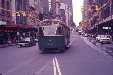 Melbourne Tram Museum
Slide - Set of 4, Les Fordham, Dec. 1963
... - view looking west from near Swanston St .3 - W2 415 southbound.... .2 - view looking west from near Swanston St .3 - W2 415 ...Set of four hanimount light brown 35mm slides - December 1963 taken by Les Fordham. .1 - PCC Class 980 (Exhibition Route 95) eastbound in Bourke St between Elizabeth and Swanston St's - has Coles Stores, London Stores, Myer and Buckley's stores in the background along with Christmas decorations. .2 - view looking west from near Swanston St .3 - W2 415 southbound in Swanston St with a traffic policeman on duty. A W7 (route 88) is waiting to cross. Has the Royal Mail House, The Leviathan building in the background. .4 - 1002 (Route 88) waiting to cross Swanston St. In the background is Douglas Trading, Southern Cross Hotel,trams, tramways, bourke st, route 95, christmas, police, route 88, tram 980, tram 1002, w7 class, pcc class, w2 class, exhibition, swanston st, tram 415, mmtb -
 Melbourne Tram Museum
Photograph - Set of 3 Colour Print/s, Postcard, Steven Altham, 29/04/2002 12:00:00 AM
... -2002 .1 - view from the west side looking at the original...-2002 .1 - view from the west side looking at the original ...Set of 3 colour prints of the re construction of the Hawthorn Tram Depot to the Watermark Apartments. All taken on 29-4-2002 .1 - view from the west side looking at the original buildings, no front wall to the depot part and the new apartment block. .2 - ditto .3 - Looking at the west end of the new block and car park entrance, no tracks laid.All have details of photograph on rear and photographers name.trams, tramways, watermark apartments, hawthorn depot, construction, tram depot -
 Bendigo Historical Society Inc.
Photograph - ROY J MITCHELL COLLECTION: LANDSCAPE PHOTO FROM POPPET HEAD ROSALIND PARK
... , looking north west from lookout tower, Rosalind Park. Queen... photograph. Image shows Bendigo landscape view, looking north west ...Colour photograph. Image shows Bendigo landscape view, looking north west from lookout tower, Rosalind Park. Queen Elizabeth Oval and grandstand in foreground. Written on back of photo: Bendigo Jan 1972, Queen Park Oval from lookout tower, January 1972 by Roy J Mitchell'Roy J Mitchellbendigo, streetscape, queen elizabeth oval -
 Bacchus Marsh & District Historical Society
Photograph, Simon Brothers Motor Garage corner of Main Street and Grant Street c.1940s
... looking south west towards Grant Street. BMDHS Location: AR/R4/S2... Marsh seen from the northern side of Main Street looking south ...This image shows one of the busiest intersections of Bacchus Marsh, the corner of Main and Grant Streets. The main building shown in the image is Simon Brothers Motor Service and Cycle Depot. In 1903 the Simon brothers, Herbert (Bert) and Walter began making Monarch bicycles and later Monarch motor cycles. In 1913 they moved into newly constructed premises shown in this image. The business operated as both a garage, service station and cycle depot. The business operated until 1948 when P. S. Carey brought the premises to expand his Grant Street car dealership business which was located next to the Simon Brothers garage. Black and white photograph showing Simon Brothers Motor garage Bacchus Marsh seen from the northern side of Main Street looking south west towards Grant Street. BMDHS Location: AR/R4/S2 Photo Album Jack Coe Collection, and digital image on BMDHS computer network.On reverse, "Jack Coe Collection"small businesses bacchus marsh, simon family bacchus marsh, simon brothers garage, petrol stations -
 Bendigo Historical Society Inc.
Photograph - MCCOLL, RANKIN AND STANISTREET COLLECTION: MONUMENT HILL MINE 655
... looking south at west side of Upper Roof.... 150' south of shaft. Picture looking south at west side ...Photograph. Black and white photo - Monument Hill Mine 655. Int stope below 640' level 150' south of shaft. Picture looking south at west side of Upper Roof.photograph, landscape, monument hill mine 655 -
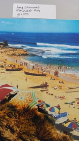 Peterborough History Group
Photograph - Surf Carnival, Newfield Bay, Jocelyn Burt
... the west looking towards the east, with the Crown of thorns visible... carnival, taken from the west looking towards the east ...Unusual choice of location by Port Campbell Surf club due to Port Campbell beach being too small. The Surf Carnival was held at Newfield Bay (possibly for two years running). Eyewitness accounts advise that one year the surf was so rough that the event was abandoned. This photograph appears to show calmer sea. In order to get the surf boats onto the beach a track was bulldozed over the sand dunes. Spectators cars were parked in the area which is now the airstrip, on the corner of the Port Campbell Peterborough Road and the Timboon Peterborough road.Town eventOriginal photograph of the surf carnival, taken from the west looking towards the east, with the Crown of thorns visible in the background. Surf boats are on the beach and umbrellas are visible. Occurred in the early 1970's.Written on the back is Jocelyn Burt, who is a photographer.newfield bay, surf lifesaving carnival, peterborough, jocelyn burt, crown of thorns rock formation -
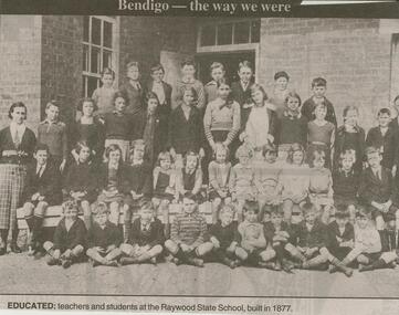 Bendigo Historical Society Inc.
Newspaper - JENNY FOLEY COLLECTION: HISTORIC
... looking north-west from St. Paul's Church tower. Visible... in the early 1900s. The photo was taken looking north-west from St ...Bendigo Advertiser ''The way we were'' from 2000. Historic: The view over Bendigo in the early 1900s. The photo was taken looking north-west from St. Paul's Church tower. Visible is the Shamrock hotel, the fire brigade depot and bell tower, the County Court House and district jail. The clip is in a folder.newspaper, bendigo advertiser, the way we were -
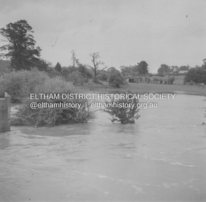
 Eltham District Historical Society Inc
Album - Photograph, J.A. McDonald, Eltham-Diamond Creek Road, 21 Oct. 1953
... for Edendale Farm. This view is looking west across the Glen Park... for Edendale Farm. This view is looking west across the Glen Park ...18 October 1956 Flood level on road at corner of Railway Parade. On the immediate left out of view is Mrs Lucy Egan's home. That house still stands today nestled up against the Wattletree Road Bridge on the other side built in 1959 and is owned by the Bakos family purchased by Mrs Heather Bakos in 1960.. Prior to the Wattletree Road bridge being built, Railway Parade extended up the alignment of present-day Gastons Road to the Eltham-Diamond Creek road which ran past the entrance of the present-day carpark for Edendale Farm. This view is looking west across the Glen Park Bridge, and the beginning of Wattletree Road which sweeps around to the right in the distance. Progress Road does not exist though a road reserve is present on maps.Record of various Shire of Eltham infrastructure works undertaken during the period of 1952-1962 involving bridge and road reconstruction projects, sometimes with Eltham Shire Council Project Reference numbers quoted. It was during this period that a number of significant improvements were made to roads and new bridges constructed within the shire that remain in place as of present day (2022). In many situations, the photos provide a tangible visible record of infrastructure that existed throughout the early days of the Shire. The album was put together by or under the direction of the Shire Engineer, J.A. McDonald.infrastructure, road construction, shire of eltham, bridge construction, eltham north, floods, floodwater, glen park bridge, 1956-10-18, diamond creek (creek), eltham, railway parade, wattletree road, wattletree road bridge, gastons road -
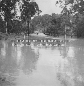
 Eltham District Historical Society Inc
Album - Photograph, J.A. McDonald, Eltham-Greensborough Road, 18 Oct. 1956
... October 1956 This view is looking west north west from the Bridge... October 1956 This view is looking west north west from the Bridge ...Bridge Street Bridge Flooding on Hill’s property 18th October 1956 This view is looking west north west from the Bridge Street Bridge across the present day Eltham Skatepark. The shed visibile in the distance is directly opposite Brisbane Street where it used to run into Susan Street but now turns the corner. To the right of the shes is the site for present-dayHarris Plumbing which was formerly occupied by Sibbel Builders; to the left the site now occupied by Bunnings. At the skyline to the right of centreeline is a gap in the trees where the railway line runs. The Silver Street bridge over the railway is visible. Beware!.. our rivers are rising (1956, October 19). The Argus (Melbourne, Vic. : 1848 - 1957), p. 1. Retrieved August 24, 2022, from http://nla.gov.au/nla.news-article84392304Record of various Shire of Eltham infrastructure works undertaken during the period of 1952-1962 involving bridge and road reconstruction projects, sometimes with Eltham Shire Council Project Reference numbers quoted. It was during this period that a number of significant improvements were made to roads and new bridges constructed within the shire that remain in place as of present day (2022). In many situations, the photos provide a tangible visible record of infrastructure that existed throughout the early days of the Shire. The album was put together by or under the direction of the Shire Engineer, J.A. McDonald.infrastructure, road construction, shire of eltham, bridge construction, bridge street bridge, eltham, eltham-greensborough road, 1956-10-18, diamond creek (creek), floods, floodwater, hill property, silver street bridge -
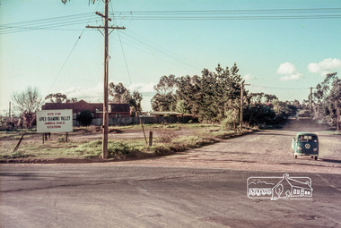 Eltham District Historical Society Inc
Slide, Site for the new Apex-Diamond Valley Ambulance Station, corner of Main Road and Grand Boulevard, Montmorency, July 1969, 1969
... View looking west along Grand Boulevard from... melbourne View looking west along Grand Boulevard from ...View looking west along Grand Boulevard from the intersection with Main Road and Panorama Avenue, Montmorency showing the site for the new Apex-Diamond Valley Ambulance Station and before construction of Apex Way, July 1969. The Eltham Apex Club conducted a Community Service Project (1965-1968) to raise funds for a new Ambulance Station to service the community. A site bounded by the intersection of Main Road, Grand Boulevard and Looker Road at Montmorency was purchased in 1969. In 1970, Eltham Shire Council undertook roadworks to construct Apex Way in preparation for the new station as well as duplicate Main Road, Lower Plenty, east of Grand Boulevard including the new Lower Plenty Bridge, which had been opened in November 1966, bordering with the City of Heidelberg.35 mm colour positive transparency Mount - Agfacolor Service (Blue)1969-07, ambulance station, apex way, grand boulevard, lower plenty, main road, montmorency, eltham ambulance station, apex-diamond valley ambulance station, eltham apex club -
 Stawell Historical Society Inc
Photograph, Great Western 1866
... of road, looking west. ... of road, looking west. Stawell Great Western 1866 Photograph ...Great Western. Part of a collection of Photographs by Mr. O.G. Armstrong as commissioned by the Shire of Stawell for the Inter-colonial and Paris Exhibition in Melbourne in 1866. Great Western began as a changing station on Concongella, northeast of the present Township. The gold rush in Great Western began in 1858 and soon after a post office and store opened. A Township was surveyed and lots sold in October 1858. The gold soon passed and the diggers went on, leaving a small settlement. In 1863 Jean Pierre Trouette and Emile Bampied, his brother-in-law, planted the first vines and build the first winery, thus setting a firm foundation upon which the present wine industry has been built. Telegraph poles and wires visible. Bakery visible in distance on right of road, looking west. stawell -
 Rutherglen Historical Society
Image, c1890
... Street, Rutherglen looking from east to west. At left of photo... photocopy of an early photograph of Main Street, Rutherglen looking ...Black and white photocopy of an early photograph of Main Street, Rutherglen looking from east to west. At left of photo is the Bank of Australasia.main street, rutherglen, bank of australasia