Showing 1429 items matching "no. 41"
-
 Wangaratta RSL Sub Branch
Container - Cigarette case, C1940
Cigarette case belonging to John Nelson Taylor QX25010;2900269;3108420 who served with the AIF 19/1/41-7/12/1945;Regular Army Special Reserve 30/1/1952-29/1/1955 and CMF 1/8/1959-2/1/1960. John was posted to 2/7 Advanced Workshops and saw active service in New Guinea. He again saw active service with the 2 Battalion Royal Australian Regiment in Japan and Korea including action at the Battle of the Hook. He joined the CMF and served with the 8/14 Victorian Mounted Rifles until final discharge on 2/1/1960. He was awarded the 1939-45 Star,Pacific Medal,War Medal 1939-45,Australian Service Medal 1939-45,Australian Active Service Medal 1945-75 with clasp Korea,Korea Medal,United Nations Service Medal (Korea),Australian Service Medal 1945-75 with clasps PNG and Korea,Australian Defence Medal and Returned from Active Service Badge. John was an active member of the Wangaratta RSL Sub Branch, served on the Committee and received a 50 year certificate of service to the RSL. He passed away in January 2021.Square silver metal case with left side hinge. A small rising sun badge is affixed in centre on top cover.Australian Commonwealth Military Forcesww2, new guinea, korean, japan, 2 bn rar, 2/7 advanced field workshops, 8/13 vmr -
Wangaratta RSL Sub Branch
Domestic object - Playing cards, C1940
Pack of playing cards belonging to John Nelson Taylor QX25010;2900269;3108420 who served with the AIF 19/1/41-7/12/1945;Regular Army Special Reserve 30/1/1952-29/1/1955 and CMF 1/8/1959-2/1/1960. John was posted to 2/7 Advanced Workshops and saw active service in New Guinea. He again saw active service with the 2 Battalion Royal Australian Regiment in Japan and Korea including action at the Battle of the Hook. He joined the CMF and served with the 8/14 Victorian Mounted Rifles until final discharge on 2/1/1960. He was awarded the 1939-45 Star,Pacific Medal,War Medal 1939-45,Australian Service Medal 1939-45,Australian Active Service Medal 1945-75 with clasp Korea,Korea Medal,United Nations Service Medal (Korea),Australian Service Medal 1945-75 with clasps PNG and Korea,Australian Defence Medal and Returned from Active Service Badge. John was an active member of the Wangaratta RSL Sub Branch, served on the Committee and received a 50 year certificate of service to the RSL. He passed away in January 2021.Light green cardboard packet containing playing cardsLucky Chips Playing Cardsww2, new guinea, korean, japan, 2 bn rar, 2/7 advanced field workshops, 8/13 vmr -
Wangaratta RSL Sub Branch
Flag, C1950
Korean flag acquired by John Nelson Taylor QX25010;2900269;3108420 who served with the AIF 19/1/41-7/12/1945;Regular Army Special Reserve 30/1/1952-29/1/1955 and CMF 1/8/1959-2/1/1960. John was posted to 2/7 Advanced Workshops and saw active service in New Guinea. He again saw active service with the 2 Battalion Royal Australian Regiment in Japan and Korea including action at the Battle of the Hook. He joined the CMF and served with the 8/14 Victorian Mounted Rifles until final discharge on 2/1/1960. He was awarded the 1939-45 Star,Pacific Medal,War Medal 1939-45,Australian Service Medal 1939-45,Australian Active Service Medal 1945-75 with clasp Korea,Korea Medal,United Nations Service Medal (Korea),Australian Service Medal 1945-75 with clasps PNG and Korea,Australian Defence Medal and Returned from Active Service Badge. John was an active member of the Wangaratta RSL Sub Branch, served on the Committee and received a 50 year certificate of service to the RSL. He passed away in January 2021.Large rectangular calico cloth with blue and red circle in centre and four groups of three short black lines in each corner. String attached to top and bottom left edge.ww2, new guinea, korean, japan, 2 bn rar, 2/7 advanced field workshops, 8/13 vmr -
Wangaratta RSL Sub Branch
Headwear - Beret, Grand’mere Knitting Company Limited, C1952
Red felt beret belonging to John Nelson Taylor QX25010;2900269;3108420 who served with the AIF 19/1/41-7/12/1945;Regular Army Special Reserve 30/1/1952-29/1/1955 and CMF 1/8/1959-2/1/1960. John was posted to 2/7 Advanced Workshops and saw active service in New Guinea. He again saw active service with the 2 Battalion Royal Australian Regiment in Japan and Korea including action at the Battle of the Hook. He joined the CMF and served with the 8/14 Victorian Mounted Rifles until final discharge on 2/1/1960. He was awarded the 1939-45 Star,Pacific Medal,War Medal 1939-45,Australian Service Medal 1939-45,Australian Active Service Medal 1945-75 with clasp Korea,Korea Medal,United Nations Service Medal (Korea),Australian Service Medal 1945-75 with clasps PNG and Korea,Australian Defence Medal and Returned from Active Service Badge. John was an active member of the Wangaratta RSL Sub Branch, served on the Committee and received a 50 year certificate of service to the RSL. He passed away in January 2021.Red felt beret with black lining and edged in black leatherSize 6 1/2 1952ww2, new guinea, korean, japan, 2 bn rar, 2/7 advanced field workshops, 8/13 vmr -
Wangaratta RSL Sub Branch
Headwear - Army Slouch Hat, Dunkerley Ltd, C1950
Army slouch hat issued to John Nelson Taylor QX25010;2900269;3108420 who served with the AIF 19/1/41-7/12/1945;Regular Army Special Reserve 30/1/1952-29/1/1955 and CMF 1/8/1959-2/1/1960. John was posted to 2/7 Advanced Workshops and saw active service in New Guinea. He again saw active service with the 2 Battalion Royal Australian Regiment in Japan and Korea including action at the Battle of the Hook. He joined the CMF and served with the 8/14 Victorian Mounted Rifles until final discharge on 2/1/1960. He was awarded the 1939-45 Star,Pacific Medal,War Medal 1939-45,Australian Service Medal 1939-45,Australian Active Service Medal 1945-75 with clasp Korea,Korea Medal,United Nations Service Medal (Korea),Australian Service Medal 1945-75 with clasps PNG and Korea,Australian Defence Medal and Returned from Active Service Badge. John was an active member of the Wangaratta RSL Sub Branch, served on the Committee and received a 50 year certificate of service to the RSL. He passed away in January 2021.Khaki felt hat with rising star badge attached to brim turned up on right side. Dark and light blue diamond patch attached to hat band/pugaree.Dunkerley Ltd Akubra Size 6 1/2 Made in Australiaww2, new guinea, korean, japan, 2 bn rar, 2/7 advanced field workshops, 8/13 vmr -
Wangaratta RSL Sub Branch
Badge - RSL, Swann & Hudson, C1971
The RSL membership badge issued to John Nelson Taylor QX25010;2900269;3108420 who served with the AIF 19/1/41-7/12/1945;Regular Army Special Reserve 30/1/1952-29/1/1955 and CMF 1/8/1959-2/1/1960. John was posted to 2/7 Advanced Workshops and saw active service in New Guinea. He again saw active service with the 2 Battalion Royal Australian Regiment in Japan and Korea including action at the Battle of the Hook. He joined the CMF and served with the 8/14 Victorian Mounted Rifles until final discharge on 2/1/1960. He was awarded the 1939-45 Star,Pacific Medal,War Medal 1939-45,Australian Service Medal 1939-45,Australian Active Service Medal 1945-75 with clasp Korea,Korea Medal,United Nations Service Medal (Korea),Australian Service Medal 1945-75 with clasps PNG and Korea,Australian Defence Medal and Returned from Active Service Badge. John was an active member of the Wangaratta RSL Sub Branch, served on the Committee and received a 50 year certificate of service to the RSL. He passed away in January 2021.The badge is a symbol of readiness at all times to render service to the country and to former comrades. No wealth or influence can purchase the RSL badge which may be worn only by those who are members of the RSL.Shield shaped badge with crown on top. White enamel with blue circle in centre above red colour scroll. Soldier, sailor and airman depicted in centre circle.Reverse - 77211 Property of League ww2, new guinea, korean, japan, 2 bn rar, 2/7 advanced field workshops, 8/13 vmr -
Wangaratta RSL Sub Branch
Medal - Medals, John Taylor
Medals awarded to John Nelson Taylor QX25010;2900269;3108420 who served with the AIF 19/1/41-7/12/1945;Regular Army Special Reserve 30/1/1952-29/1/1955 and CMF 1/8/1959-2/1/1960. John was posted to 2/7 Advanced Workshops and saw active service in New Guinea. He again saw active service with the 2 Battalion Royal Australian Regiment in Japan and Korea including action at the Battle of the Hook. He joined the CMF and served with the 8/14 Victorian Mounted Rifles until final discharge on 2/1/1960. He was awarded the 1939-45 Star,Pacific Medal,War Medal 1939-45,Australian Service Medal 1939-45,Australian Active Service Medal 1945-75 with clasp Korea,Korea Medal,United Nations Service Medal (Korea),Australian Service Medal 1945-75 with clasps PNG and Korea,Australian Defence Medal and Returned from Active Service Badge. John was an active member of the Wangaratta RSL Sub Branch, served on the Committee and received a 50 year certificate of service to the RSL. He passed away in January 2021.Two star and eight round shaped medals all attached to various striped ribbons mounted on red felt covered board.QX25010 JN Taylorww2, new guinea, korean, japan, 2 bn rar, 2/7 advanced field workshops, 8/13 vmr -
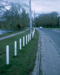 Ballarat Tramway Museum
Slide - 27 mm sq slide/s - set of 11, Lilian Butler, Wendouree Parade and Sturt St West, Sep. 1971
Yields information about the streetscapes of Ballarat depot to Pleasant St route and in particular buildings and people that crewed the trams.Set of eleven Colour 27 x 27 mm slide in a Kodachrome cardboard mount. .1 - Wendouree Parade looking west towards St Aidans Drive - the gate pillars can be seen. .2 - ditto looking west - Fairyland .3 - ditto looking towards Gardens Loop .4 - No. 41 at Gardens Loop, with destination of Gardens via Drummond North .5 - ditto showing Mt Pleasant .6 - ditto, just past the now BTM Depot Junction. .7 - Carlton St - showing the gates .8 - Looking towards Hamilton Ave from within Carlton St loop with the signal showing red. .9 - Turning from Hamilton Ave into Sturt St West. .10 - Sturt St west looking east with the Loreto convent walls on the left hand side. .11 - Sturt St - Pleasant St intersection - showing road surface, a tram coming towards the intersection and buildings on either side. Slide mount date September 1971. Photo from the collection of Lilian Butler.ballarat, tramways, trams, wendouree parade, st aidans drive, gardens loop, depot junction, carlton st, carlton st loop, signals, sturt st west, pleasant st, tram 41 -
![Journal series, The Law Book Company Limited, The Australian digest : being a digest of the reported decisions of the Australian courts and of Australian appeals to the Privy Council, [1962]](/media/collectors/54a9bcce2162f11b1cc120f2/items/54b3598a2162f10f380e167f/item-media/54e6912f2162f70124b433f8/item-fit-380x285.jpg) RMIT GSBL Justice Smith Collection
RMIT GSBL Justice Smith CollectionJournal series, The Law Book Company Limited, The Australian digest : being a digest of the reported decisions of the Australian courts and of Australian appeals to the Privy Council, [1962]
Previous owners: T. H. Smith, T. W. SmithSecond edition No. of volumes: 91 Volume range: Vol. 1-50 + Vol. 1961-1994 [First edition?] + Masters 1948-1980 + Permanent supplement to second edition, Interim supplements to 1986 & 1987 Missing volumes: Vol. 1962 Editors: Malor, J. (Vol. 1-30, 1961-1974 & Masters 1948-1977) Jelbart, J. M. (Vol. 31-34, 1967-1980 & Masters 1967-1980) Bennett, J. M. (Vol. 35-40) Fitzhenry, K. (Vol. 41-50, 1981-1987, Permanent supplement to 1986 & Interim supplement to 1987) McPaul, B. (Vol. 1961-1980 & Masters 1948-1980) Lewis, F. (Vol. 1988-1990) Mariani, P. L. (Vol. 1991) Selvadurai, N. (Vol. 1992-1994 & Interim supplement 1987-1993) "Provides summaries of Australia reported case law since 1825. Cases are classified by subject and issue. Consists of 83 titles (58 volumes) updated each year." (ulrichsweb.com) Most items still have dust jackets ISSN: 00671843law reports: digests: etc. -- australia -
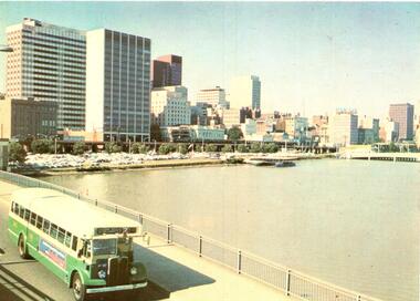 Melbourne Tram Museum
Postcard, Murfett Publishers, MMTB Bus 583 AEC Mk111 no 583, early to mid 1970's
Postcard - full colour, Divided back type of MMTB Bus 583 AEC Mk111 no 583 Reg : AT083 entered service 1953 body by Martin and King - two man crew, 41 seats. Notes from Rod Atkins 24/5/2019: Bound for : "Fisherman's Bend via Williamtown Road" on Spencer Street Bridge heading south. When: It's what is missing in the photo gives us a the clue. It after 1968 as the new Stock Exchange building at 357 Collins Street is completed. but before 1973 when the new MLC building was open at 303 Collins Street on corner of Elizabeth Street. But the "2" between the destination and route number boxes on bus tells us its after November 1970. Therefore I would date the post card photograph to around 1971-1972 and prior to the start of the third viaduct between Flinders St and Spencer St. Published by National View by Murfett Publishers Australia. Has the details on the rear with place for stamp, address etc and logo.trams, tramways, king st, bridges, railways, buses, fisherman's bend -
 Bendigo Historical Society Inc.
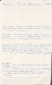
Document - PRINCESS ALEXANDRA COY & TRIBUTORS - EXTRACTS ON PRINCESS ALEXANDRA MINE
Handwritten notes on the Princess Alexandra Mine. 24/11/1900 Shaft sunk 7 feet & timbered 15 feet total from plat 26 feet and from surface 2,311 feet. 8/12/1900 Finished sinking shaft, removed penthouse and cistern, fixed skids, ladders etc & are now enlarging 2225 ft plat. 16/2/1901 West x cut at 2285 ft. driven 17 feet, total 41 ft passed through 3 lavas and in the end have a back underlying west and carrying stone. Winze below 2225 feet, sunk 13 feet, total 18 feet - - at 15 ft saw a couple of colours of gold. Last Report 21/12/1901 Xcut east from 2165 ft in 13 ft in hard sandstone spurs - - Expect to get more stone near the black leader which is about 20 ft up. Next report as 'United Devonshire' on 4/1/1902. Notes prepared by Albert Richardson.document, gold, princess alexandra coy & tributors, princess alexandra coy & tributors, extracts on princess alexandra mine, united devonshire, mm reports -
 Bendigo Military Museum
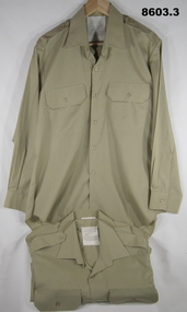
Uniform - SHIRTS, SERVICE DRESS, ARMY, 1982, 1983, 1991
1. 2. 3. Shirts - khaki colour, cotton/polyester, long sleeves with button cuff, collar, shoulder epaulettes, two front pockets with button down flap. Plastic buttons. White cotton fabric manufacturers label, back below collar. 2. Left sleeve - fabric shoulder patch. Rising Sun Badge with Queen's Crown and lettering embroidery. "THE AUSTRALIAN ARMY".Manufacturer's information - black ink print. 1. "A.G.C.F./ VIC 1982/ ^ / 8405.66.088.7068/ SIZE 41/84/. SERVICE NO./ NAME/ DO NOT BOIL. OR WRING/ MACHINE WASHABLE/ DRIP DRY IRON NIGHTLY/ WITH WARM IRON". 2. "A.G.C.F./ VIC 1983/ ^/ 8405.66.088.7065/ SIZE 40/88". SERVICE NO./ NAME/ DO NOT BOIL. OR WRING/ MACHINE WASHABLE/ DRIP DRY IRON NIGHTLY/ WITH WARM IRON". 3. "ADI/ VIC 1991/ ^/ 8405.66.088.7102/ SERVICE NO./ NAME/ 65% POLYESTER/ 35% COTTON" "DO NOT BOIL. OR WRING/ MACHINE WASHABLE/ DRIP DRY IRON NIGHTLY/ WITH WARM IRON". uniforms, army, service dress, shirts, passchendaele barracks trust -
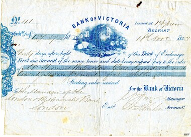 Flagstaff Hill Maritime Museum and Village
Currency - Banknote Belfast, Bank of Victoria, 1853
The promissory note issued at Belfast, now Port Fairy, Victoria by the “Bank of Victoria” is an early example of currency issued by a private bank. This note was issued in 1853 the same year that the bank commenced business in Belfast. Details of the first production of a banknote backed by the Australian Government occurred on 1 May 1913 following the "Australian Notes Act of 1910" (Australian National Museum). The first building the Bank of Victoria purchased in Belfast was of timber and later sold. Smith & Watts Architects advertised for tenders in the Melbourne Argus on Thursday 29/4/1869 for the erection of a substantial building that is now occupied by Moyne Shire Council in Cox Street. A meeting of the Directors of the Bank of Victoria elected on 1 October 1852. A ballot took place for four directors resulting in Wm. Highett Esq. Wm F. Splatt, Esq. M.L.C., Alex. Wilson, Esq. and W.H. Tuckett” elected as Directors. It was reported from a later meeting in “The Argus” Melbourne on 3 August 1853 that a branch had opened in Swanston Street, Melbourne on 3rd January 1852 with Henry Miller as Chairman of the Board and J. Matheson as the Manager; followed by Geelong on 12 August 1852. Then at the request of “influential inhabitants”, the Belfast branch commenced on 11 May 1853, which had “already met with very general support and encouragement”. This was a colonial bank at the time of vast pastoral runs and gold speculation – how "Mr Thomas [....ton?]" came by his fortune of One Hundred and Twenty-Seven Pound and five shillings can only be wondered at until further research reveals the story. This promissory note records the early colonial system of banking and reflects the economic growth and entrepreneurship of the South West Region of Victoria.Banknote of fine paper. There is a fold multi-crease down the centre top to bottom, lighter creasing across the top and angular creasing to the bottom left and right-hand corners. Yellow spotting is visible across the object breaking through the grey blue colour of the paper. A dark ink blot appears near the top right-hand corner. The left-hand side of the banknote is uneven. The back of the document has darker spotting, a used dirty look patina and some insect spotting. Horizontal crease markings can be seen creating quarter marks. The front of the banknote reads: "No.41/ Exch.ge for £127.57- Bank of Victoria/Issued at 1% prem/Thirty days after Sight of this Third of Exchange/First and Second of the same tenor and date being unpaid pay to the order of/Mr. Thomas [Raliston?]/One hundred and twenty seven pounds five shillings Sterling silver received/To the Manager of the London Westminister Bank London/for the Bank of Victoria [signed?] Manager/Ent.d [?] Robertson Account.t. The blue printed Bank of Victoria logo features a world globe, sailing ships, wool bails, sheep, colonial building and mining tools. flagstaff hill, warrnambool, maritime village, maritime museum, flagstaff hill maritime museum and village, shipwreck coast, great ocean road, promissory notes, bank notes, bank of victoria, smith & watts, smith & watts architects, 1853, william highett, william f. splatt, alex wilson, w.h. tuckett, henry miller, money miller, belfast (now port fairy) -
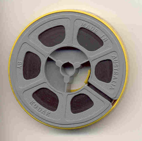 Ballarat Tramway Museum
Film - Movie Film & Box, Kodak, 1960s
Yields information in movie film format of Ballarat trams in 1971 at the time of one of the closure tours and, a enthusiast tour, how the system operated and was used by people., Yields information in movie film format of Ballarat trams in 1971 at the time of one of the closure tours and, a enthusiast tour, how the system operated and was used by people.Movie film - 8mm, approx. 4.14 mins, with white leader strip on a plastic reel, within a Kodak movie yellow plastic container. Has been transferred to DVD - see Reg item 4100 as Segment No. 4. Filmed and made by an unknown person. Synopsis: based on time - Colour film Title "Ballarat trams specials" 0:00 No. 41 and two other bogie trams loading passengers outside the Ballarat railway station. 0:12 Image of R class loco and K class as 2nd loco at the station and train 0:18 Inside a bogie tram looking through saloon door showing the HTT logo. 0:23 From the front of a tram, or 39 turning from Lydiard St Nth into Sturt St and then proceeding along Sturt St. 0:31 Short sequence inside the tram with some passengers in the view 0:39 No. 21, showing Special in Sturt St West and then the two bogie trams following. 1:08 21 turning from Sturt St West into Hamilton Ave, followed by 41, 35 and 37 and then loading photographers. 1:58 As above north of Gardens Loop in Wendouree Parade. 2:07 Interior view of tram moving at speed, then Forest St corner showing church, and Wendouree Parade. 2:24 Drummond St Sth, crossing two trams at Bell St loop 2:29 Sebastopol line, from the window, heading towards the terminus. 2:44 No. 32 at Sebastopol terminus with the pole being turned. 3:01 Single trucker climbing Sturt St hill towards Lydiard St Nth. 3:17 No. 21 turning from Lydiard St Nth into Sturt St 3:31 Bogie tram climbing Sturt St hill towards Lydiard St Nth 3:55 Crossing the railway level crossing in Lydiard St Nth from the window of the tram. 4:02 Train departing from station – very poor sequence – appears to be a K class locomotive. 4:15 end Placed in a blue cardboard box specially made for the item 30/08/2010.trams, tramways, ballarat, vintage train, bell st, level crossings, lydiard st nth, sturt st west, tram 41, tram 39, tram 21, tram 35, tram 37, tram 32 -
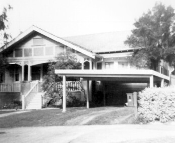 Surrey Hills Historical Society Collection
Photograph, 3 Norfolk Road Surrey Hills - home of Mr and Mrs Albert Ernest Vine
Albert Ernest Vine Snr, was a City of Camberwell Councillor from 1926-1934 and 1937-1944. He was also Mayor of Camberwell in 1940/41. There is a sundial in the Surrey Gardens erected in his memory. Known as Ernest, he and his wife Edith (nee Sword) lived at 3 Norfolk Road from 1920-1945. Earlier addresses are on file in Alan Holt card index. He was active in Surrey Hills Progress Association. He was the son of William James Vine (1860-1920) and Sarah Elizabeth Gunner (1859-1941). W J Vine & Co Timber Yards were located at 587-593 Canterbury Road. Elizabeth Gunner's brother was Henry Gabez Gunner (1862-1940), a builder in the Surrey Hills area. Box Hill Reporter (6/6/19) records that Ernest applied to Camberwell City Council for permission to subdivide land in Norfolk Road with a frontage of 85' into 2 equal lots for a dwelling to be erected on each, one for himself and the other for his mother. Albert Ernest & Edith Vine had the following children: Albert Ernest Jnr (b 1904), Robert (b 1908), Edgar (b 1912), Inez (b 1915) and Beth (b 1918). Both No 1 & No 3 were demolished c1970.Black and white photo of a 1920s style single-storey weatherbaord home with leadlight windows, a tiled roof and a wide veranda supported by timber columns on stucco pillars. The veranda has a simple timber balastrade and a flight of timber stairs to it. There does not appear to be front fence. A simple sloped double carport on the RHS and proud of the house is of a later date.norfolk road, californian bungalows, w j vine & co timber yards, mr william james vine, mr albert ernest vine, mrs edith vine, miss edith sword -
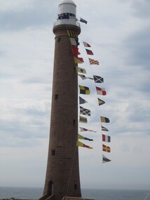 Parks Victoria - Gabo Island Lightstation
Flags & Pennants, navigational, signal
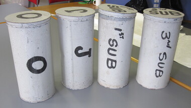
The 41 alphabetic and numeric visual signalling flags (including substitute and answering pennants) have either square or pointed ends. They are made of bunting, a coarse fabric of worsted (open yarn wool) in various colour combinations. Some of the flags are marked with inscriptions, for example “B”. Attachments to the flags include hemp rope and metal clips. Each flag has its own galvanised canister and lid, each of which is painted grey and marked with a letter, number or word. The flags were used for communicating messages to passing ships. Knowledge of visual signalling was mandatory for all lightkeepers and all lightstations maintained a set of flags. Although used for centuries, visual flag signalling formally developed in the nineteenth century and was published internationally as a system in 1857. By the early twentieth century it had developed into an effective means of conveying all kinds of short range visual messages. The signal flags and canisters at Gabo Island form a complete set and are not historically linked to the lightstation and their provenance is unknown. It is known however that they originate from a lightstation in Victoria and for some years were on loan from AMSA to the Queenscliff Maritime Museum, where they were held in storage and not displayed. Three of the six lightstations that Parks Victoria manages have sets of signal flags in their collections. Forty navigational signal alphabet flags & numeral pennants. Flags are made of wool. -
 Parks Victoria - Gabo Island Lightstation
Flag canisters
The 41 alphabetic and numeric visual signalling flags (including substitute and answering pennants) have either square or pointed ends. They are made of bunting, a coarse fabric of worsted (open yarn wool) in various colour combinations. Some of the flags are marked with inscriptions, for example “B”. Attachments to the flags include hemp rope and metal clips. Each flag has its own galvanised canister and lid, each of which is painted grey and marked with a letter, number or word. The flags were used for communicating messages to passing ships. Knowledge of visual signalling was mandatory for all lightkeepers and all lightstations maintained a set of flags. Although used for centuries, visual flag signalling formally developed in the nineteenth century and was published internationally as a system in 1857. By the early twentieth century it had developed into an effective means of conveying all kinds of short range visual messages. The signal flags and canisters at Gabo Island form a complete set and are not historically linked to the lightstation and their provenance is unknown. It is known however that they originate from a lightstation in Victoria and for some years were on loan from AMSA to the Queenscliff Maritime Museum, where they were held in storage and not displayed. In three of the six lightstations that Parks Victoria manages have sets of signal flags in their collections. Forty-one galvanised canisters with separate lids. The canisters are painted a grey/white colour and have either numbers, letters or words painted on the lid and on the cannister in black paint. There are variations in the style of canister and in the style of the inscriptions. -
Wangaratta RSL Sub Branch
Badge - RASB- Active Service, C1945
The Returned from Active Service Badge (RASB) is a military badge and awarded to John Nelson Taylor QX25010;2900269;3108420 who served with the AIF 19/1/41-7/12/1945;Regular Army Special Reserve 30/1/1952-29/1/1955 and CMF 1/8/1959-2/1/1960. John was posted to 2/7 Advanced Workshops and saw active service in New Guinea. He again saw active service with the 2 Battalion Royal Australian Regiment in Japan and Korea including action at the Battle of the Hook. He joined the CMF and served with the 8/14 Victorian Mounted Rifles until final discharge on 2/1/1960. He was awarded the 1939-45 Star,Pacific Medal,War Medal 1939-45,Australian Service Medal 1939-45,Australian Active Service Medal 1945-75 with clasp Korea,Korea Medal,United Nations Service Medal (Korea),Australian Service Medal 1945-75 with clasps PNG and Korea,Australian Defence Medal and Returned from Active Service Badge. John was an active member of the Wangaratta RSL Sub Branch, served on the Committee and received a 50 year certificate of service to the RSL. He passed away in January 2021.The Returned from Active Service Badge (RASB) is issued to Australian Defence Force personnel who have rendered warlike service. The badge enables individuals to display their involvement in warlike service while wearing civilian attire. It is worn when the wearing of service medals is not appropriate or possible. Brass badge features tri-services (with an anchor, wings and Rising Sun) surmounted by the crown, with a boomerang underneath with the text 'RETURNED FROM ACTIVE SERVICE' . The reverse of the badge has a pair of pin clips.Reverse -384439 - issued by the C’wealth Govt. 1945ww2, new guinea, korean, japan, 2 bn rar, 2/7 advanced field workshops, 8/13 vmr -
 Eltham District Historical Society Inc
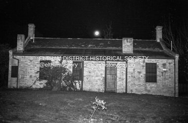
Photograph (Item) - Print, Nick O'Brien, Untitled (Shillinglaw Cottage at night, full moon), 1988
Nick O'Brien 1988 Entrant No. 41 Ref: Series 34, Items 17, 71-74 SHIRE OF ELTHAM COMMUNITY PHOTOGRAPHIC SURVEY Photography is an artform which many of us practice, sometimes purely for artistic pursuit, sometimes to record the people and events in our lives. In 1988, as part of a local Bicentennial project, the Shire of Eltham conducted the Eltham Community Photographic Survey. Up to 100 entries were to be selected by a panel of photographers for entry into the Eltham Photographic Survey Exhibition. Entries had to be submitted by May 13, 1988. Entrants whose images were selected for the exhibition were contacted and requested to further submit an entry form providing entrant’s name, area of residence, age, and proposed captions. These details were then used to produce labels for the exhibition mounts. Where negatives had not been supplied, these were requested to support the display of printed enlargements mounted on 10” x 8” cardboard. The mounted prints were made available post exhibition for sale at $8.50 each for colour prints and $7.00 for B&W prints. Residents in the Shire were invited to collect a free roll of film and take a photograph of what they either liked or did not like about the area. A total of 160 entrants submitted multiple entries for the exhibition. Of those selected for exhibition, entrants ranged in age from 9 to 70 years. All custom colour and black and white printing for the exhibition was completed by Wattle Studios of Eltham. The Eltham Photographic Survey was jointly auspiced by the Shire of Eltham and Wattle Studios, of 953 Main Road, Eltham. The project was greatly assisted by: • David McRitchie, Media Studies Lecturer Victoria College, Rusden Campus. • Ian and Annette Toohill of Wattle Studios • Tracy Naughton, Eltham Community Arts Officer • Neville Emerson Pty. Ltd. • Superior Press, Eltham • Kodak Australasia Pty. Ltd. • Agfa Gevaert Ltd. • Townsend Colourtech Pty. Ltd. • The Australian Bicentennial Authority • Eleanor Bowers, Secretary, Eltham Arts Council The exhibition was placed on display in the Woolworths Arcade, Eltham between Monday June 6th and Saturday June 11, 1988. It was also intended to hold the exhibition at a venue in the Shire’s North Riding from Monday, June 20 to Friday June 24. It was then displayed at the Were Street Theatre, Montmorency from Friday, June 24 to Thursday, July 7. Series 34: Eltham Community Photographic Survey 1988 - Prints & Documentation Series consists of 117 photographs of Shire scenes taken by members of the community. Items I - 41 are larger photographs mounted on card, which were exhibited. Items 42 - 117 are unmounted copies, alternative takes and other entries. Corresponding negatives contained in Series 35: Eltham Community Photographic Survey 1988 – Negatives which consists of 267 colour and B&W negatives and one colour slide of Shire scenes taken by members of the community. The negatives are arranged by the entrant number of the photographer. The Eltham Community Photographic Survey collection is significant to the local community as it was curated by the local community - ordinary people of all ages - representing what they liked and did not like in the area where they lived. It represents an unfiltered representation of the Shire of Eltham as it was in 1988. It also represents one of many projects as part of the national programme of events and celebrations to commemorate the bicentenary. It is a time capsule of life in the 1980s of this urban and rural municipality in Melbourne's north. Front: Entrant No. and name on printed label Rear: Entrant No., name and address on printed label; also 'Series 34' and the 'Item No.' in pencilshire of eltham archives, bicentennial project, eltham, eltham community photographic survey, eltham photographic survey exhibition, series 34, series 35, eltham common, film - ilford fp4, nick o'brien, scan - 35mm negative, shillinglaw cottage -
 Eltham District Historical Society Inc
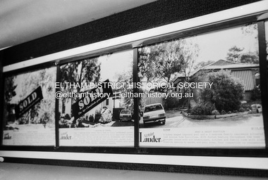
Photograph (Item) - Print, Nick O'Brien, Untitled (Real Estate Window Display), 1988
Nick O'Brien 1988 Entrant No. 41 Ref: Series 34, Items 17, 71-74 SHIRE OF ELTHAM COMMUNITY PHOTOGRAPHIC SURVEY Photography is an artform which many of us practice, sometimes purely for artistic pursuit, sometimes to record the people and events in our lives. In 1988, as part of a local Bicentennial project, the Shire of Eltham conducted the Eltham Community Photographic Survey. Up to 100 entries were to be selected by a panel of photographers for entry into the Eltham Photographic Survey Exhibition. Entries had to be submitted by May 13, 1988. Entrants whose images were selected for the exhibition were contacted and requested to further submit an entry form providing entrant’s name, area of residence, age, and proposed captions. These details were then used to produce labels for the exhibition mounts. Where negatives had not been supplied, these were requested to support the display of printed enlargements mounted on 10” x 8” cardboard. The mounted prints were made available post exhibition for sale at $8.50 each for colour prints and $7.00 for B&W prints. Residents in the Shire were invited to collect a free roll of film and take a photograph of what they either liked or did not like about the area. A total of 160 entrants submitted multiple entries for the exhibition. Of those selected for exhibition, entrants ranged in age from 9 to 70 years. All custom colour and black and white printing for the exhibition was completed by Wattle Studios of Eltham. The Eltham Photographic Survey was jointly auspiced by the Shire of Eltham and Wattle Studios, of 953 Main Road, Eltham. The project was greatly assisted by: • David McRitchie, Media Studies Lecturer Victoria College, Rusden Campus. • Ian and Annette Toohill of Wattle Studios • Tracy Naughton, Eltham Community Arts Officer • Neville Emerson Pty. Ltd. • Superior Press, Eltham • Kodak Australasia Pty. Ltd. • Agfa Gevaert Ltd. • Townsend Colourtech Pty. Ltd. • The Australian Bicentennial Authority • Eleanor Bowers, Secretary, Eltham Arts Council The exhibition was placed on display in the Woolworths Arcade, Eltham between Monday June 6th and Saturday June 11, 1988. It was also intended to hold the exhibition at a venue in the Shire’s North Riding from Monday, June 20 to Friday June 24. It was then displayed at the Were Street Theatre, Montmorency from Friday, June 24 to Thursday, July 7. Series 34: Eltham Community Photographic Survey 1988 - Prints & Documentation Series consists of 117 photographs of Shire scenes taken by members of the community. Items I - 41 are larger photographs mounted on card, which were exhibited. Items 42 - 117 are unmounted copies, alternative takes and other entries. Corresponding negatives contained in Series 35: Eltham Community Photographic Survey 1988 – Negatives which consists of 267 colour and B&W negatives and one colour slide of Shire scenes taken by members of the community. The negatives are arranged by the entrant number of the photographer. The Eltham Community Photographic Survey collection is significant to the local community as it was curated by the local community - ordinary people of all ages - representing what they liked and did not like in the area where they lived. It represents an unfiltered representation of the Shire of Eltham as it was in 1988. It also represents one of many projects as part of the national programme of events and celebrations to commemorate the bicentenary. It is a time capsule of life in the 1980s of this urban and rural municipality in Melbourne's north. Rear: 'Series 34' and the 'Item No.' in orange inkshire of eltham archives, bicentennial project, eltham, eltham community photographic survey, samantha robertson, series 34, series 35, film - ilford fp4, nick o'brien, real estate advertisement, scan - 35mm negative, nicholas lauder real estate -
 Eltham District Historical Society Inc
Photograph, Liz Pidgeon, Heritage Excursion; Maroondah Aqueduct, 3 September 2016, 3 September 2016
Newsletter No., 229, August 2016 Heritage Excursion - Maroondah Aqueduct Walk - Saturday 3rd September The Maroondah Aqueduct was once a major link in Melbourne’s water supply system. It was built between 1886 and 1891 to transfer water from the Watts River near Healesville to the Preston Reservoir. It was 66 km in length, made up of 41 km of open channel, 10 km of tunnel through hills and 15 km of pipeline across stream valleys known as inverted siphons. The section of the aqueduct through the Eltham area has been abandoned since the 1980s but the open channel has largely been retained. A recreational path follows the aqueduct reserve. For our excursion on 3rd September we intend to walk along the section of the aqueduct adjacent to Allendale Road. This is a section not visited on previous excursions and includes the transition from open channel to the inverted siphon across the Diamond Creek valley. Apart from the aqueduct itself the main feature of the walk is the extensive views across Eltham North and Diamond Creek. Along the way we will talk about the history of the aqueduct and the area. This easy walk is about 3 km return and will take 2 to 2.5 hours. It will start at 2pm at the junction of Allendale Road with Godber Road and Zig Zag Road North, officially Diamond Creek, but on the northern boundary of Eltham. (Melway ref.12 B10). Born Digitalmaroondah aqueduct, eltham north, activities, eltham district historical society, heritage excursion, acqueduct trail, sign -
 Eltham District Historical Society Inc
Photograph, Liz Pidgeon, Heritage Excursion; Maroondah Aqueduct, 3 September 2016, 3 September 2016
Newsletter No., 229, August 2016 Heritage Excursion - Maroondah Aqueduct Walk - Saturday 3rd September The Maroondah Aqueduct was once a major link in Melbourne’s water supply system. It was built between 1886 and 1891 to transfer water from the Watts River near Healesville to the Preston Reservoir. It was 66 km in length, made up of 41 km of open channel, 10 km of tunnel through hills and 15 km of pipeline across stream valleys known as inverted siphons. The section of the aqueduct through the Eltham area has been abandoned since the 1980s but the open channel has largely been retained. A recreational path follows the aqueduct reserve. For our excursion on 3rd September we intend to walk along the section of the aqueduct adjacent to Allendale Road. This is a section not visited on previous excursions and includes the transition from open channel to the inverted siphon across the Diamond Creek valley. Apart from the aqueduct itself the main feature of the walk is the extensive views across Eltham North and Diamond Creek. Along the way we will talk about the history of the aqueduct and the area. This easy walk is about 3 km return and will take 2 to 2.5 hours. It will start at 2pm at the junction of Allendale Road with Godber Road and Zig Zag Road North, officially Diamond Creek, but on the northern boundary of Eltham. (Melway ref.12 B10). Born Digitalmaroondah aqueduct, eltham north, activities, eltham district historical society, heritage excursion, acqueduct trail, diamond creek -
 Eltham District Historical Society Inc
Photograph, Liz Pidgeon, Heritage Excursion; Maroondah Aqueduct, 3 September 2016, 3 September 2016
Newsletter No., 229, August 2016 Heritage Excursion - Maroondah Aqueduct Walk - Saturday 3rd September The Maroondah Aqueduct was once a major link in Melbourne’s water supply system. It was built between 1886 and 1891 to transfer water from the Watts River near Healesville to the Preston Reservoir. It was 66 km in length, made up of 41 km of open channel, 10 km of tunnel through hills and 15 km of pipeline across stream valleys known as inverted siphons. The section of the aqueduct through the Eltham area has been abandoned since the 1980s but the open channel has largely been retained. A recreational path follows the aqueduct reserve. For our excursion on 3rd September we intend to walk along the section of the aqueduct adjacent to Allendale Road. This is a section not visited on previous excursions and includes the transition from open channel to the inverted siphon across the Diamond Creek valley. Apart from the aqueduct itself the main feature of the walk is the extensive views across Eltham North and Diamond Creek. Along the way we will talk about the history of the aqueduct and the area. This easy walk is about 3 km return and will take 2 to 2.5 hours. It will start at 2pm at the junction of Allendale Road with Godber Road and Zig Zag Road North, officially Diamond Creek, but on the northern boundary of Eltham. (Melway ref.12 B10). Born Digitalmaroondah aqueduct, eltham north, activities, eltham district historical society, heritage excursion, acqueduct trail, sign -
 Eltham District Historical Society Inc
Photograph, Liz Pidgeon, Heritage Excursion; Maroondah Aqueduct, 3 September 2016, 3 September 2016
Newsletter No., 229, August 2016 Heritage Excursion - Maroondah Aqueduct Walk - Saturday 3rd September The Maroondah Aqueduct was once a major link in Melbourne’s water supply system. It was built between 1886 and 1891 to transfer water from the Watts River near Healesville to the Preston Reservoir. It was 66 km in length, made up of 41 km of open channel, 10 km of tunnel through hills and 15 km of pipeline across stream valleys known as inverted siphons. The section of the aqueduct through the Eltham area has been abandoned since the 1980s but the open channel has largely been retained. A recreational path follows the aqueduct reserve. For our excursion on 3rd September we intend to walk along the section of the aqueduct adjacent to Allendale Road. This is a section not visited on previous excursions and includes the transition from open channel to the inverted siphon across the Diamond Creek valley. Apart from the aqueduct itself the main feature of the walk is the extensive views across Eltham North and Diamond Creek. Along the way we will talk about the history of the aqueduct and the area. This easy walk is about 3 km return and will take 2 to 2.5 hours. It will start at 2pm at the junction of Allendale Road with Godber Road and Zig Zag Road North, officially Diamond Creek, but on the northern boundary of Eltham. (Melway ref.12 B10). Born Digitalmaroondah aqueduct, eltham north, activities, eltham district historical society, heritage excursion, acqueduct trail -
 Eltham District Historical Society Inc
Photograph, Liz Pidgeon, Heritage Excursion; Maroondah Aqueduct, 3 September 2016, 3 September 2016
Intersection with local Street signs Newsletter No., 229, August 2016 Heritage Excursion - Maroondah Aqueduct Walk - Saturday 3rd September The Maroondah Aqueduct was once a major link in Melbourne’s water supply system. It was built between 1886 and 1891 to transfer water from the Watts River near Healesville to the Preston Reservoir. It was 66 km in length, made up of 41 km of open channel, 10 km of tunnel through hills and 15 km of pipeline across stream valleys known as inverted siphons. The section of the aqueduct through the Eltham area has been abandoned since the 1980s but the open channel has largely been retained. A recreational path follows the aqueduct reserve. For our excursion on 3rd September we intend to walk along the section of the aqueduct adjacent to Allendale Road. This is a section not visited on previous excursions and includes the transition from open channel to the inverted siphon across the Diamond Creek valley. Apart from the aqueduct itself the main feature of the walk is the extensive views across Eltham North and Diamond Creek. Along the way we will talk about the history of the aqueduct and the area. This easy walk is about 3 km return and will take 2 to 2.5 hours. It will start at 2pm at the junction of Allendale Road with Godber Road and Zig Zag Road North, officially Diamond Creek, but on the northern boundary of Eltham. (Melway ref.12 B10). Born Digitalmaroondah aqueduct, eltham north, activities, eltham district historical society, heritage excursion, street signs, acqueduct trail, allendale rd, godber rd, zig zag road, intersection -
 Eltham District Historical Society Inc
Photograph, Liz Pidgeon, Heritage Excursion; Maroondah Aqueduct, 3 September 2016, 3 September 2016
Newsletter No., 229, August 2016 Heritage Excursion - Maroondah Aqueduct Walk - Saturday 3rd September The Maroondah Aqueduct was once a major link in Melbourne’s water supply system. It was built between 1886 and 1891 to transfer water from the Watts River near Healesville to the Preston Reservoir. It was 66 km in length, made up of 41 km of open channel, 10 km of tunnel through hills and 15 km of pipeline across stream valleys known as inverted siphons. The section of the aqueduct through the Eltham area has been abandoned since the 1980s but the open channel has largely been retained. A recreational path follows the aqueduct reserve. For our excursion on 3rd September we intend to walk along the section of the aqueduct adjacent to Allendale Road. This is a section not visited on previous excursions and includes the transition from open channel to the inverted siphon across the Diamond Creek valley. Apart from the aqueduct itself the main feature of the walk is the extensive views across Eltham North and Diamond Creek. Along the way we will talk about the history of the aqueduct and the area. This easy walk is about 3 km return and will take 2 to 2.5 hours. It will start at 2pm at the junction of Allendale Road with Godber Road and Zig Zag Road North, officially Diamond Creek, but on the northern boundary of Eltham. (Melway ref.12 B10). Born Digitalmaroondah aqueduct, eltham north, activities, eltham district historical society, heritage excursion, acqueduct trail -
 Eltham District Historical Society Inc
Photograph, Liz Pidgeon, Heritage Excursion; Maroondah Aqueduct, 3 September 2016, 3 September 2016
Property related to Yarra Valley Water, Diamond Creek Newsletter No., 229, August 2016 Heritage Excursion - Maroondah Aqueduct Walk - Saturday 3rd September The Maroondah Aqueduct was once a major link in Melbourne’s water supply system. It was built between 1886 and 1891 to transfer water from the Watts River near Healesville to the Preston Reservoir. It was 66 km in length, made up of 41 km of open channel, 10 km of tunnel through hills and 15 km of pipeline across stream valleys known as inverted siphons. The section of the aqueduct through the Eltham area has been abandoned since the 1980s but the open channel has largely been retained. A recreational path follows the aqueduct reserve. For our excursion on 3rd September we intend to walk along the section of the aqueduct adjacent to Allendale Road. This is a section not visited on previous excursions and includes the transition from open channel to the inverted siphon across the Diamond Creek valley. Apart from the aqueduct itself the main feature of the walk is the extensive views across Eltham North and Diamond Creek. Along the way we will talk about the history of the aqueduct and the area. This easy walk is about 3 km return and will take 2 to 2.5 hours. It will start at 2pm at the junction of Allendale Road with Godber Road and Zig Zag Road North, officially Diamond Creek, but on the northern boundary of Eltham. (Melway ref.12 B10). Born Digitalmaroondah aqueduct, eltham north, activities, eltham district historical society, heritage excursion, yarra valley water, diamond creek -
 Eltham District Historical Society Inc
Photograph, Liz Pidgeon, Heritage Excursion; Maroondah Aqueduct, 3 September 2016, 3 September 2016
Sign for Yarra Valley Water at Diamond Creek property Newsletter No., 229, August 2016 Heritage Excursion - Maroondah Aqueduct Walk - Saturday 3rd September The Maroondah Aqueduct was once a major link in Melbourne’s water supply system. It was built between 1886 and 1891 to transfer water from the Watts River near Healesville to the Preston Reservoir. It was 66 km in length, made up of 41 km of open channel, 10 km of tunnel through hills and 15 km of pipeline across stream valleys known as inverted siphons. The section of the aqueduct through the Eltham area has been abandoned since the 1980s but the open channel has largely been retained. A recreational path follows the aqueduct reserve. For our excursion on 3rd September we intend to walk along the section of the aqueduct adjacent to Allendale Road. This is a section not visited on previous excursions and includes the transition from open channel to the inverted siphon across the Diamond Creek valley. Apart from the aqueduct itself the main feature of the walk is the extensive views across Eltham North and Diamond Creek. Along the way we will talk about the history of the aqueduct and the area. This easy walk is about 3 km return and will take 2 to 2.5 hours. It will start at 2pm at the junction of Allendale Road with Godber Road and Zig Zag Road North, officially Diamond Creek, but on the northern boundary of Eltham. (Melway ref.12 B10). Born Digitalmaroondah aqueduct, eltham north, activities, eltham district historical society, heritage excursion, diamond creek, yarra valley water, sign -
 Eltham District Historical Society Inc
Photograph, Liz Pidgeon, Heritage Excursion; Maroondah Aqueduct, 3 September 2016, 3 September 2016
Newsletter No., 229, August 2016 Heritage Excursion - Maroondah Aqueduct Walk - Saturday 3rd September The Maroondah Aqueduct was once a major link in Melbourne’s water supply system. It was built between 1886 and 1891 to transfer water from the Watts River near Healesville to the Preston Reservoir. It was 66 km in length, made up of 41 km of open channel, 10 km of tunnel through hills and 15 km of pipeline across stream valleys known as inverted siphons. The section of the aqueduct through the Eltham area has been abandoned since the 1980s but the open channel has largely been retained. A recreational path follows the aqueduct reserve. For our excursion on 3rd September we intend to walk along the section of the aqueduct adjacent to Allendale Road. This is a section not visited on previous excursions and includes the transition from open channel to the inverted siphon across the Diamond Creek valley. Apart from the aqueduct itself the main feature of the walk is the extensive views across Eltham North and Diamond Creek. Along the way we will talk about the history of the aqueduct and the area. This easy walk is about 3 km return and will take 2 to 2.5 hours. It will start at 2pm at the junction of Allendale Road with Godber Road and Zig Zag Road North, officially Diamond Creek, but on the northern boundary of Eltham. (Melway ref.12 B10). Born Digitalmaroondah aqueduct, eltham north, activities, eltham district historical society, heritage excursion, acqueduct trail -
 Eltham District Historical Society Inc
Photograph, Liz Pidgeon, Heritage Excursion; Maroondah Aqueduct, 3 September 2016, 3 September 2016
View of Diamond Creek Newsletter No., 229, August 2016 Heritage Excursion - Maroondah Aqueduct Walk - Saturday 3rd September The Maroondah Aqueduct was once a major link in Melbourne’s water supply system. It was built between 1886 and 1891 to transfer water from the Watts River near Healesville to the Preston Reservoir. It was 66 km in length, made up of 41 km of open channel, 10 km of tunnel through hills and 15 km of pipeline across stream valleys known as inverted siphons. The section of the aqueduct through the Eltham area has been abandoned since the 1980s but the open channel has largely been retained. A recreational path follows the aqueduct reserve. For our excursion on 3rd September we intend to walk along the section of the aqueduct adjacent to Allendale Road. This is a section not visited on previous excursions and includes the transition from open channel to the inverted siphon across the Diamond Creek valley. Apart from the aqueduct itself the main feature of the walk is the extensive views across Eltham North and Diamond Creek. Along the way we will talk about the history of the aqueduct and the area. This easy walk is about 3 km return and will take 2 to 2.5 hours. It will start at 2pm at the junction of Allendale Road with Godber Road and Zig Zag Road North, officially Diamond Creek, but on the northern boundary of Eltham. (Melway ref.12 B10). Born Digitalmaroondah aqueduct, eltham north, activities, eltham district historical society, heritage excursion, diamond creek, acqueduct trail