Showing 16995 items
matching plenty-river
-
 Greensborough Historical Society
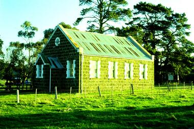
Slide - Photograph, John Ramsdale, Bluestone Church on Plenty Road Mill Park: Slide 30, 1990s
Photograph shows a bluestone church on Plenty Road Mill Park.Part of the John Ramsdale collection of slides and audio visual material.Colour photograph scanned from slide.No maker's marks. No caption on slide.plenty road mill park, bluestone church -
 Greensborough Historical Society
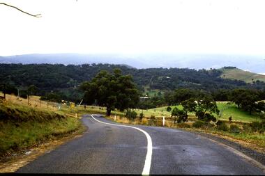
Slide - Photograph, John Ramsdale, Between Whittlesea and Upper Plenty: Slide 33, 1990s
Photograph shows a country road between Whittlesea and Upper PlentyPart of the John Ramsdale collection of slides and audio visual material.Colour photograph scanned from slide.No maker's marks. No caption on slide.whittlesea, upper plenty -
 Greensborough Historical Society
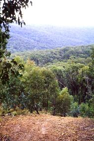
Slide - Photograph, John Ramsdale, Upper Plenty: Slide 35, 1990s
Photograph shows a heavily treed hillside in the upper Plenty area.Part of the John Ramsdale collection of slides and audio visual material.Colour photograph scanned from slide.No maker's marks. No caption on slide.upper plenty -
 Greensborough Historical Society
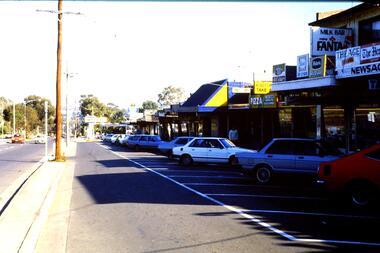
Slide - Photograph, John Ramsdale, Main Road shops, Lower Plenty: Slide 70, 1990s
Photograph shows a shopping centre - Main Road Lower PlentyPart of the John Ramsdale collection of slides and audio visual material.Colour photograph scanned from slide.No maker's marks. No caption on slide.lower plenty, main road lower plenty -
 Greensborough Historical Society
Business card - Digital Image, Plenty Valley Printing Greensborough, 2016_
Plenty Valley Printing is a Greensborough graphic design and printing business.Coloured business cardplenty valley printing, para road greensborough -
 Orbost & District Historical Society
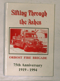
books, Sifting Through The Ashes, 1994
The book was collated by Debbie Hall. Orbost Fire brigade was founded in 1919. The first captain was George Hodgson, assisted by Lieutenant Reg Macalister, Secretary J.F.McCoy and fifteen members. .As there was no fire station the ree l ( a cast off fro m the Bairnsdale Brigade ) w as kep t in the shed at the back of the Council Chambers until the present Station was built in 1922 in its present location in Gladstone Street, Orbost. This book is a written record of the first one hundred years of the Orbost Fire Brigade.Two copies of a paperback book with a white cover and red print. On the cover is a photo of a fire truck in a rectangular frame. The book was produced for the 75th Anniversary of Orbost Fire Brigade 1919-1994. The book contains black and white photographs of Fire brigade activities and extracts from the "Snowy River Mail".In blue pen - "Presented to the Orbost Historical Society from Orbost Fire Brigade - November 12th 1994"book orbost-fire-brigade -
 Marysville & District Historical Society
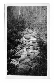
Photograph (item) - Black and white photograph, Mabel Russell Sutherland, December 1935
A black and white photograph of the Taggerty River near Marysville in Victoria.A black and white photograph of the Taggerty River near Marysville in Victoria.SUTHERLAND/ STUDIO/ HEALESVILLE Taggerty River/ Dec. 1935 19taggerty river, marysville, victoria, photograph, mabel russell sutherland, sutherland studio -
 Greensborough Historical Society
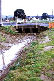
Slide - Photograph, John Ramsdale, Near Plenty Road South Morang: Slide 53, 1990s
Photograph shows drain and culvert near Plenty Road South Morang.Part of the John Ramsdale collection of slides and audio visual material.Colour photograph scanned from slide.No maker's marks. No caption on slide.plenty road south morang -
 Greensborough Historical Society
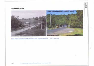
Article and Photograph, Lower Plenty Bridge, 2016_
2 Photographs of the area around the Lower Plenty Bridge, 1906 and 2014.This photograph and text was copied from a Facebook site. Members are people who lived in the Greensborough area and share their reminiscences of the area with others. The site is administered by a GHS member but is not officially affiliated with the Society. Any information is the opinion of the contributor. Article and photograph sourced from social media.lower plenty -
 Greensborough Historical Society
Book - Digital Image, School at the crossing place: Lower Plenty Primary School 1874-1974 LP1295, 1874-1974
The Centenary history of Lower Plenty Primary School from 1874-1974. Digital (scanned) copy of the Centenary book.lower plenty primary school -
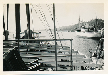 Mission to Seafarers Victoria
Photograph - Photograph, Black and white, Allan Charles Quinn, Passing ship on Elbe River, 4 June 1950
This series of photographs captures life at sea and the conditions on the ship M/S "Mongabarra" Goteborg in 1950.This photograph is part of the Allan Quinn collection, which is a pictorial autobiography, and it represents one of many moments of his time abroad as a seafarer.Black and white photograph of the Elbe River in Germany. In the foreground is a lounge area with chairs and railing. Behind this are masts, rigging and rope near what appears to be a jetty with partial roofing. In the middle ground is the Elbe River running from the bottom right to middle left of the photograph. In the background is a passing ship and a mountain.germany, 1950, ship, deck, mast, chairs, mongabarra, allan quinn collection, allan quinn, tailing, elbe river, mointain -
Clunes Museum
Artwork, other - LITHOGRAPH, Adelaide, From the River Torrens
Dark sepia scene, on linen surface paper. Depicting Torrens River, with bridge and city buildings in background. Tree lined banks, 2 figures on left bank and 3 rowing boats on river. 4 figures on right bank. Picture is mounted on 10mm thick chipboard which is coloured black.Scheil - A Irwin Sclithograph, torrens river -
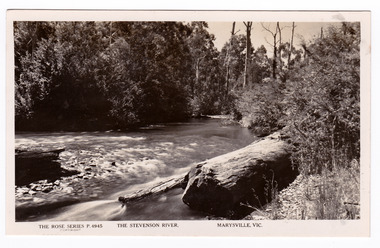 Marysville & District Historical Society
Postcard (item) - Black and white postcard, Rose Stereograph Company, The Stevenson River, Marysville, Vic, 1913-1967
A postcard in a series produced by the Rose Stereograph Company in Victoria, Australia as a souvenir of Marysville.A black and white photograph of the Stevenson (Steavenson) River that runs through Marysville in Victoria. The Steavenson River is named after the Victorian Assistant Commissioner of Roads and Bridges, John Steavenson who arrived here in the early 1860s.POST CARD The "Rose" Series/ De Luxe A Real Photograph/ Produced in Australia Published by the Rose Stereograph Co.,/ Armadale, Victoriastevenson river, steavenson river, marysville, victoria, p. 4945, rose series postcard, postcard, souvenir, john steavenson -
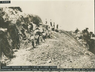 Lorne Historical Society
Photograph, Workmen with hand tools Great Ocean Road near Wye River
Photograph of G,O,R. construction area at Wye River, showing construction worker cutting into the side of the hill with picks.g.o.r.; wye-river; construction-workers; -
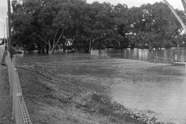 Charlton Golden Grains Museum Inc
Photograph, 1973 flooded Avoca River
B/W photograph of 1973 flooded Avoca River. View West side of Paterson Bridge behind Shire Office -
 Victorian Aboriginal Corporation for Languages
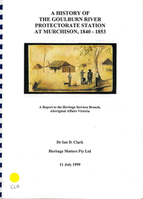
Book, Ian D Clark, A history of the Goulburn River Protectorate Station at Murchison, 1840-1853 : a report to the Heritage Services Branch, Aboriginal Affairs Victoria, 1999
Contains histories of the Aboriginal Protectors in the Goulburn River area and their work with the people in this region using journal entries and historical records.maps, b&w photograph, colour illustrations, tables -
 Greensborough Historical Society
Slide - Photograph, John Ramsdale, Lower Plenty with Odyssey House in background: Slide 103, 1990s
Photograph shows gum trees in paddock. This is in Lower Plenty with Odyssey House in background.Part of the John Ramsdale collection of slides and audio visual material.Colour photograph scanned from slide.No maker's marks. No caption on slide.lower plenty, odyssey house -
 Greensborough Historical Society
Slide - Photograph, John Ramsdale, Lower Plenty and Rosanna Golf Course: Slide 111, 1990s
Photograph shows a rural scene in Lower Plenty and Rosanna Golf Course to rightPart of the John Ramsdale collection of slides and audio visual material.Colour photograph scanned from slide.No maker's marks. No caption on slide.lower plenty, rosanna golf course -
 Greensborough Historical Society
Photographs, Montmorency: old pavilion. Lower Plenty Oval 1979, 17/04/1979
2 photographs of the old pavilion at Lower Plenty Oval, Montmorency, April 1979.2 colour photographs.peter graham, montmorency, lower plenty oval -
 Eltham District Historical Society Inc
Photograph - Aerial Photograph, Landata, Lower Plenty, Feb. 1956
Centred on present day 217 Old Eltham Road, Lower Plenty bounded by Pitt Street to north, Yarra River to south, Main Road to east and Bonds Road to west. Historic Aerial Imagery Source: Landata.vic.gov.au Aerial Photo Details: Project No :250 Project : MELBOURNE OUTER SUBURBS PROJECT Run : 17 Frame : 116 Date : 02/1956 Film Type : B/W Camera : EAG9 Flying Height : 10000 Scale : 12000 Film Number : 1176 GDA2020 : 37°43'58"S, 145°07'49"E MGA2020 : 335237, 5822186 (55) Melways : 21 E10 (ed. 42)aerial photo, 1956-02, neil webster collection, eltham, main road, bonds road, elham, lower plenty, melway 21e10, pitt street, yarra river -
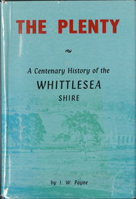 Eltham District Historical Society Inc
Book, J. W. Payne, The Plenty: A Centenary History of the Whittlesea Shire, 1975
This book traces the one hundered years of the development of the Shire of Whittlesea, from the discovery by Hume and Hovell in 1824 to the time of the centenary in 1975. The intervening years saw the settlement of Vandemonians, Sydney-siders, English, Scots, Irish and Germans, Black Thursday, the building of the Yan Yean Reservoir, the Plenty River flour millls, the timber industry, fruit-growing and export and vineyards. Personalities and pubs, subdivisions, stories of the Findon Hunt Club and various Shires including Epping. History of education and transiton from rural to urban in the south of the Shire. The work is illustrated with maps and photographs. The Shire is now the City of Whittlesea and is an immediate neighbour to the north of the Shire of Nillumbik. shire of whittlesea -
 Greensborough Historical Society
Newspaper clipping, Diamond Valley Leader, Enlisting help: stories honour Anzacs; with Yarra Plenty Regional Library flyer advertising Discover your Anzac story program, 26/11/2014
Research by Maureen Jones about Sgt. Reginald Simms and Nurse Elizabeth Gallagher as part of Yarra Plenty Regional Library publication program about people from Nillumbik, Banyule and Whittlesea who served in World War 1. Includes Yarra Plenty Regional Library flyer about the project.Front page colour image and article and image p. 5. Small colour flyer.world war 1, maureen jones, yarra plenty regional library, reginald simms, elizabeth gallagher -
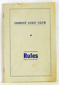 Orbost & District Historical Society
booklet, Snowy River Mail as "Mail" Print, Orbost Golf Club Rules, 1968
Published by the Orbost Golf Club.The golf club was established in 1906 it was originally formed as the Snowy River Golf Club and played on private land near the banks of the Snowy River just to the south of town. In the 1930’s the Golf Club relocated to its present site and was renamed Orbost Golf Club. The land was shared by the Show grounds and Racing Club. Orbost Golf Club later acquired the land outright to provide a permanent home for golfers in Orbost and surrounding district.A thin, 24pp booklet with a grey cover titled "Orbost Golf Club Rules". It contains the rules of the Orbost Golf Club and has a loose sheet with amendments. The cover has blue print.orbost-golf-club recreation sport golf -
Lakes Entrance Regional Historical Society (operating as Lakes Entrance History Centre & Museum)
Postcard, Bulmer, 1915 - 1920 c
Also a second postcard showing Sylvia Gasson later Wigg in rowing boat on Nicholson River 05494.1 13.5 x 9 cmBlack and white postcard showing Sylvia Gasson nee Brodribb seated in a rowing boat on Nicholson River showing high bank opposite with dead trees on top Nicholson VictoriaEvening Shadowsw Nicholson Rivergenealogy -
 Greensborough Historical Society
Map, Melbourne and Metropolitan Board of Works. Survey Division, MMBW, Yarra 2500 / 11.21. Bundoora, east of Plenty Road, 1979_01
Melbourne and Metropolitan Board of Works. Yarra 2500 [base map] 11-21. Bundoora, east of Plenty Road. Parish of Keelbundoora 2856, Municipalities of Diamond Valley 257, Preston 225 and Whittlesea 239. Prominent streets include: Grimshaw Street, Settlement Road and Plenty Road. Includes Yulong Park.MMBW Map in 1:2500 [scale] series. Cream parchment with green tape reinforcing on edges and punched holes on left edge.mmbw, melbourne and metropolitan board of works, shire of diamond valley, bundoora - maps -
 Melbourne Tram Museum
Document - Report, Parliamentary Public Works Committee, "Parliamentary Public Works Committee Report Plenty Road, Preston, Tramway Extension Enquiry, 1967
Report contained within a light brown card folder, containing a photocopy of report titled "Parliamentary Public Works Committee Report (including map) on The Plenty Road, Preston, Tramway Extension Enquiry - 1967". Report stapled in top right hand corner, 15 pages examining the extension of the East Preston route to Bolderwood Parade. Map shows extension proposed, bus routes, railway lines, streets - folded into 4.AETA stamp on front and inside sheet and "4E6" in ink on front cover. AETA stamp on the bottom right hand corner of the map.trams, tramways, east preston, new tramway, bolderwood parade, proposals -
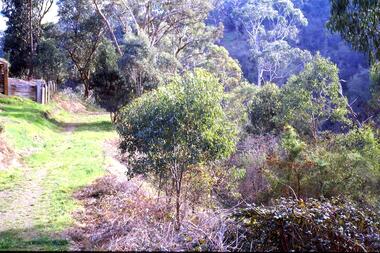 Greensborough Historical Society
Slide - Photograph, John Ramsdale, Plenty Gorge with blackberries: Slide 87, 1990s
Photograph shows a track through trees and retaining wall. This is Plenty Gorge with blackberries in foreground.Part of the John Ramsdale collection of slides and audio visual material.Colour photograph scanned from slide.No maker's marks. No caption on slide.plenty gorge, blackberries -
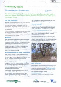 Greensborough Historical Society
Booklet, Parks Victoria et al, Plenty Gorge Park fire recovery, 15/04/2020
Community update on rehabilitation of the section of Plenty Gorge Park affected by a bushfire in December 20196 p. text and colour photographs and mapplenty gorge park, bushfires, blue lake, yellow gum park, plenty -
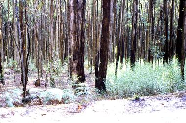 Greensborough Historical Society
Slide - Photograph, John Ramsdale, Post bushfire regrowth, Upper Plenty: Slide 31, 1990s
Photograph shows a bush scene with trees that are regenerating after a bushfire in the Upper Plenty area.Part of the John Ramsdale collection of slides and audio visual material.Colour photograph scanned from slide.No maker's marks. Caption on slide "T & Bs"bushfires, upper plenty, vegetation -
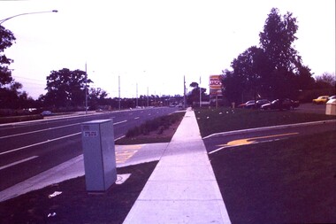 Greensborough Historical Society
Slide - Photograph, John Ramsdale, Plenty Road: Slide 13, 1990s
Photograph shows a 3 lane road with Hungry Jacks sign - Plenty Road Bundoora.Part of the John Ramsdale collection of slides and audio visual material.Colour photograph scanned from slide.No maker's marks. No caption on slide.plenty road bundoora